3
More Annotations


4


2
Favourite Annotations


5


2
Text
ENGLAND MAP AND BRITAIN TRAVEL GUIDE Anstruther. Situated in the east corner of Fife between Crail and Pittenweem, Anstruther, known locally as Ainster, is a picturesque port. Anstruther's harbour once thrived on the herring trade but nowadays its berths are mostly occupied by pleasure vessels. The village is a beguiling place to explore with its cobbled streets,
narrow wynds
MAP OF THE UNITED KINGDOM About The United Kingdom. The United Kingdom lies off the north western coast of mainland Europe. It is a soverign state with a total area of about 248,500 square kilometres or 95,900 square miles.MAP OF ENGLAND
England is the largest country in Great Britian. It makes up 130,395 sq km out of the 243,305 sq km that makes up the United Kingdom. It is bordered at the North by Scotland and at the West by Wales. It is closer to continental Europe than any other part of the UK, France is only 33km away via the English Channel or 50km away via the Channel LARGE MAP OF ENGLAND Large Map of England. Map showing major roads, cites and towns in England. This map is made using GPS points provided from a variety of Government sources so it is an accurate representation. It can be used for offline use such as university or school projects or just forpersonal reference.
WALES MAP - UK MAPS
Wales is a country that is part of the United Kingdom and also Great Britian (United Kingdom minus Northern Ireland). It shares it's only land border to the east with England. It makes up 20,779 km sq (8,023 sq mi) out of 243,305 sq km that makes up the United Kingdom. Wales has a diverse landscape and is particularly mountainous in the central IRELAND MAP : LÉARSCÁIL NA HEIREANN : ÉIRE Ireland / Éire is an island to the east of Great Britian. Ireland is the third-largest island in Europe. Ireland is divided between the Republic of Ireland, which makes up 5/6 of the island, and Northern Ireland, which is part of the United Kingdom. The island comprises mostly of low-lying mountains which surround a THE DEEP SEA ADVENTURE : WEYMOUTH DORSET ENGLAND : UK The Deep Sea Adventure A family attraction situated within a Victorian Grain Warehouse, the Deep Sea Adventure is an exhibition which details shipwrecks and adventures ofMAP OF SCOTLAND
Map of Scotland. Scotland map showing major roads, cites and towns. This map is an accurate representation as it is made using latatute and longitude points provided from a variety of sources. This map can be used for offline use such as school or university projects or just for personal reference. FOCHABERS SCOTLAND : MORAY TOURIST INFORMATION Fochabers. Lying midway between Inverness and Aberdeen and some four miles from the Moray Firth Coast, Fochabers is a charming wee village well-situated for walking and touring attractions in the north east of Scotland. Charming though Fochabers may be the village's history is not so pretty. The original Fochabers was a somewhat untidy affair BUCKIE SCOTLAND : MORAY TOURIST INFORMATION, ATTRACTIONS The tourist attractions in Buckie are largely related to the sea. In Clunie Place is the Buckie District Fishing Heritage Museum which along with the Buckie Drifter on Freuchny Road details the history of the fishing industry in Buckie and along the Morayshire coast. Art lovers can visit the library in Buckie for the Peter Anson Gallerywhich
ENGLAND MAP AND BRITAIN TRAVEL GUIDE Anstruther. Situated in the east corner of Fife between Crail and Pittenweem, Anstruther, known locally as Ainster, is a picturesque port. Anstruther's harbour once thrived on the herring trade but nowadays its berths are mostly occupied by pleasure vessels. The village is a beguiling place to explore with its cobbled streets,narrow wynds
UNITED KINGDOM TRAVEL GUIDE United Kingdom : Travel Guides to the UK. Alloa. Lying 2 miles from Clackmannan and 6 miles east of Stirling, Alloa was once a thriving port but is now known for Alloa Tower, the oldest and largest s . PHOTOS - ITRAVELUK.CO.UK United Kingdom photos - pictures and images of , UK IRELAND MAP : LÉARSCÁIL NA HEIREANN : ÉIRE Ireland / Éire is an island to the east of Great Britian. Ireland is the third-largest island in Europe. Ireland is divided between the Republic of Ireland, which makes up 5/6 of the island, and Northern Ireland, which is part of the United Kingdom. The island comprises mostly of low-lying mountains which surround a ST MAWES ENGLAND : CORNWALL TOURIST INFORMATION One of Cornwall's finest little villages, quaint St Mawes slopes to the sea with streets lined by pretty thatched cottages, villas and gardens. Flanked by Carrick Roads and the River Percuil, St Mawes is an old fishing village that has always depended upon the water for its survival. Fishing is no longer as important here as it once was andnow
MARGATE ENGLAND : KENT TOURIST INFORMATION, ATTRACTIONS Margate. As the first seaside resort in the country, Margate has drawn visitors ever since the 1730s. The 700 year old harbour had been extensively used by the sailing hoys which regularly plied their trade from London. However, a new cargo inundated the town in the 18th century when boatloads of holiday makers came to try out BenjaminBeale's
COLYFORD ENGLAND : DEVON TOURIST INFORMATION, ATTRACTIONS Colyford lies on the tourist route between East Devon and West Dorset. This small village in the Axe Valley lies just 2km away from the seaside resort of Seaton to the south with Colyton to the north. Visiting Colyford and the surrounding area promises a quiet getaway, a great destination for walking, birdwatching, sailing, horse riding HASTINGS ENGLAND : SUSSEX TOURIST INFORMATION, ATTRACTIONS Hastings "We conquered the Saxon at Hastings, and a nice little handful it is." Rudyard Kipling Best known for its historical importance in the Battle of 1066 between the Normans and the Saxons, Hastings draws the tourist trade on three fronts. FOCHABERS SCOTLAND : MORAY TOURIST INFORMATION Fochabers. Lying midway between Inverness and Aberdeen and some four miles from the Moray Firth Coast, Fochabers is a charming wee village well-situated for walking and touring attractions in the north east of Scotland. Charming though Fochabers may be the village's history is not so pretty. The original Fochabers was a somewhat untidy affair WHERE IS NEWNHAM? ENGLAND, UK, WORCESTERSHIRE MAPS This map of is accurate as far as I am aware. Please use the contact link at the top of the page if you notice any errors or would like to contact us for any other reason about this map. ENGLAND MAP AND BRITAIN TRAVEL GUIDE Anstruther. Situated in the east corner of Fife between Crail and Pittenweem, Anstruther, known locally as Ainster, is a picturesque port. Anstruther's harbour once thrived on the herring trade but nowadays its berths are mostly occupied by pleasure vessels. The village is a beguiling place to explore with its cobbled streets,narrow wynds
MAP OF ENGLAND
England is the largest country in Great Britian. It makes up 130,395 sq km out of the 243,305 sq km that makes up the United Kingdom. It is bordered at the North by Scotland and at the West by Wales. It is closer to continental Europe than any other part of the UK, France is only 33km away via the English Channel or 50km away via the Channel LARGE MAP OF ENGLAND Large Map of England. Map showing major roads, cites and towns in England. This map is made using GPS points provided from a variety of Government sources so it is an accurate representation. It can be used for offline use such as university or school projects or just forpersonal reference.
ST MAWES ENGLAND : CORNWALL TOURIST INFORMATION One of Cornwall's finest little villages, quaint St Mawes slopes to the sea with streets lined by pretty thatched cottages, villas and gardens. Flanked by Carrick Roads and the River Percuil, St Mawes is an old fishing village that has always depended upon the water for its survival. Fishing is no longer as important here as it once was andnow
MARGATE ENGLAND : KENT TOURIST INFORMATION, ATTRACTIONS Margate. As the first seaside resort in the country, Margate has drawn visitors ever since the 1730s. The 700 year old harbour had been extensively used by the sailing hoys which regularly plied their trade from London. However, a new cargo inundated the town in the 18th century when boatloads of holiday makers came to try out BenjaminBeale's
COLYFORD ENGLAND : DEVON TOURIST INFORMATION, ATTRACTIONS Colyford lies on the tourist route between East Devon and West Dorset. This small village in the Axe Valley lies just 2km away from the seaside resort of Seaton to the south with Colyton to the north. Visiting Colyford and the surrounding area promises a quiet getaway, a great destination for walking, birdwatching, sailing, horse ridingMAP OF SCOTLAND
Map of Scotland. Scotland map showing major roads, cites and towns. This map is an accurate representation as it is made using latatute and longitude points provided from a variety of sources. This map can be used for offline use such as school or university projects or just for personal reference. HASTINGS ENGLAND : SUSSEX TOURIST INFORMATION, ATTRACTIONS Hastings "We conquered the Saxon at Hastings, and a nice little handful it is." Rudyard Kipling Best known for its historical importance in the Battle of 1066 between the Normans and the Saxons, Hastings draws the tourist trade on three fronts. FOCHABERS SCOTLAND : MORAY TOURIST INFORMATION Fochabers. Lying midway between Inverness and Aberdeen and some four miles from the Moray Firth Coast, Fochabers is a charming wee village well-situated for walking and touring attractions in the north east of Scotland. Charming though Fochabers may be the village's history is not so pretty. The original Fochabers was a somewhat untidy affair BUCKIE SCOTLAND : MORAY TOURIST INFORMATION, ATTRACTIONS The tourist attractions in Buckie are largely related to the sea. In Clunie Place is the Buckie District Fishing Heritage Museum which along with the Buckie Drifter on Freuchny Road details the history of the fishing industry in Buckie and along the Morayshire coast. Art lovers can visit the library in Buckie for the Peter Anson Gallerywhich
ENGLAND MAP AND BRITAIN TRAVEL GUIDE Anstruther. Situated in the east corner of Fife between Crail and Pittenweem, Anstruther, known locally as Ainster, is a picturesque port. Anstruther's harbour once thrived on the herring trade but nowadays its berths are mostly occupied by pleasure vessels. The village is a beguiling place to explore with its cobbled streets,narrow wynds
UNITED KINGDOM TRAVEL GUIDE United Kingdom : Travel Guides to the UK. Alloa. Lying 2 miles from Clackmannan and 6 miles east of Stirling, Alloa was once a thriving port but is now known for Alloa Tower, the oldest and largest s . MAP OF THE UNITED KINGDOM About The United Kingdom. The United Kingdom lies off the north western coast of mainland Europe. It is a soverign state with a total area of about 248,500 square kilometres or 95,900 square miles. ST MAWES ENGLAND : CORNWALL TOURIST INFORMATION One of Cornwall's finest little villages, quaint St Mawes slopes to the sea with streets lined by pretty thatched cottages, villas and gardens. Flanked by Carrick Roads and the River Percuil, St Mawes is an old fishing village that has always depended upon the water for its survival. Fishing is no longer as important here as it once was andnow
WHERE IS NEWNHAM? ENGLAND, UK, WORCESTERSHIRE MAPS This map of is accurate as far as I am aware. Please use the contact link at the top of the page if you notice any errors or would like to contact us for any other reason about this map.GREAT WITCOMBE MAP
Closest 30 Towns or Cities to Great Witcombe (Population over 500) Brockworth 2.95km Shurdington 3.89km Hucclecote 3.9km Leckhampton 5.06km Charlton Kings 5.9km Churchdown 6.01km Painswick 6.54km Innsworth 7.2km Gloucester 8.02km Cheltenham 8.17km Staverton 9.55km Stroud 10.34km Quedgeley 10.47km Randwick 10.92km Swindon 11.35km Chalford 11.35km Hardwicke 11.6km WHERE IS HORNSEA, ENGLAND, UK? YORKSHIREMAPS This map of is accurate as far as I am aware. Please use the contact link at the top of the page if you notice any errors or would like to contact us for any other reason about this map. WHERE IS HAWKEDON, ENGLAND, UK? SUFFOLKMAPS This map of is accurate as far as I am aware. Please use the contact link at the top of the page if you notice any errors or would like to contact us for any other reason about this map. WHERE IS MAYFIELD, ENGLAND, UK? SUSSEXMAPS This map of is accurate as far as I am aware. Please use the contact link at the top of the page if you notice any errors or would like to contact us for any other reason about this map. WHERE IS LINTON, ENGLAND, UK? KENTMAPS This map of is accurate as far as I am aware. Please use the contact link at the top of the page if you notice any errors or would like to contact us for any other reason about this map. ENGLAND MAP AND BRITAIN TRAVEL GUIDE Anstruther. Situated in the east corner of Fife between Crail and Pittenweem, Anstruther, known locally as Ainster, is a picturesque port. Anstruther's harbour once thrived on the herring trade but nowadays its berths are mostly occupied by pleasure vessels. The village is a beguiling place to explore with its cobbled streets,narrow wynds
UNITED KINGDOM TRAVEL GUIDE United Kingdom : Travel Guides to the UK. Alloa. Lying 2 miles from Clackmannan and 6 miles east of Stirling, Alloa was once a thriving port but is now known for Alloa Tower, the oldest and largest s .MAP OF ENGLAND
England is the largest country in Great Britian. It makes up 130,395 sq km out of the 243,305 sq km that makes up the United Kingdom. It is bordered at the North by Scotland and at the West by Wales. It is closer to continental Europe than any other part of the UK, France is only 33km away via the English Channel or 50km away via the Channel MAP OF THE UNITED KINGDOM About The United Kingdom. The United Kingdom lies off the north western coast of mainland Europe. It is a soverign state with a total area of about 248,500 square kilometres or 95,900 square miles. LARGE MAP OF ENGLAND Large Map of England. Map showing major roads, cites and towns in England. This map is made using GPS points provided from a variety of Government sources so it is an accurate representation. It can be used for offline use such as university or school projects or just forpersonal reference.
ST MAWES ENGLAND : CORNWALL TOURIST INFORMATION One of Cornwall's finest little villages, quaint St Mawes slopes to the sea with streets lined by pretty thatched cottages, villas and gardens. Flanked by Carrick Roads and the River Percuil, St Mawes is an old fishing village that has always depended upon the water for its survival. Fishing is no longer as important here as it once was andnow
MARGATE ENGLAND : KENT TOURIST INFORMATION, ATTRACTIONS Margate. As the first seaside resort in the country, Margate has drawn visitors ever since the 1730s. The 700 year old harbour had been extensively used by the sailing hoys which regularly plied their trade from London. However, a new cargo inundated the town in the 18th century when boatloads of holiday makers came to try out BenjaminBeale's
THE DEEP SEA ADVENTURE : WEYMOUTH DORSET ENGLAND : UK The Deep Sea Adventure A family attraction situated within a Victorian Grain Warehouse, the Deep Sea Adventure is an exhibition which details shipwrecks and adventures ofMAP OF SCOTLAND
Map of Scotland. Scotland map showing major roads, cites and towns. This map is an accurate representation as it is made using latatute and longitude points provided from a variety of sources. This map can be used for offline use such as school or university projects or just for personal reference. BUCKIE SCOTLAND : MORAY TOURIST INFORMATION, ATTRACTIONS The tourist attractions in Buckie are largely related to the sea. In Clunie Place is the Buckie District Fishing Heritage Museum which along with the Buckie Drifter on Freuchny Road details the history of the fishing industry in Buckie and along the Morayshire coast. Art lovers can visit the library in Buckie for the Peter Anson Gallerywhich
ENGLAND MAP AND BRITAIN TRAVEL GUIDE Anstruther. Situated in the east corner of Fife between Crail and Pittenweem, Anstruther, known locally as Ainster, is a picturesque port. Anstruther's harbour once thrived on the herring trade but nowadays its berths are mostly occupied by pleasure vessels. The village is a beguiling place to explore with its cobbled streets,narrow wynds
UNITED KINGDOM TRAVEL GUIDE United Kingdom : Travel Guides to the UK. Alloa. Lying 2 miles from Clackmannan and 6 miles east of Stirling, Alloa was once a thriving port but is now known for Alloa Tower, the oldest and largest s . PHOTOS - ITRAVELUK.CO.UK United Kingdom photos - pictures and images of , UK ST MAWES ENGLAND : CORNWALL TOURIST INFORMATION One of Cornwall's finest little villages, quaint St Mawes slopes to the sea with streets lined by pretty thatched cottages, villas and gardens. Flanked by Carrick Roads and the River Percuil, St Mawes is an old fishing village that has always depended upon the water for its survival. Fishing is no longer as important here as it once was andnow
MARGATE ENGLAND : KENT TOURIST INFORMATION, ATTRACTIONS Margate. As the first seaside resort in the country, Margate has drawn visitors ever since the 1730s. The 700 year old harbour had been extensively used by the sailing hoys which regularly plied their trade from London. However, a new cargo inundated the town in the 18th century when boatloads of holiday makers came to try out BenjaminBeale's
GREAT WITCOMBE MAP
Closest 30 Towns or Cities to Great Witcombe (Population over 500) Brockworth 2.95km Shurdington 3.89km Hucclecote 3.9km Leckhampton 5.06km Charlton Kings 5.9km Churchdown 6.01km Painswick 6.54km Innsworth 7.2km Gloucester 8.02km Cheltenham 8.17km Staverton 9.55km Stroud 10.34km Quedgeley 10.47km Randwick 10.92km Swindon 11.35km Chalford 11.35km Hardwicke 11.6km WHERE IS NEWNHAM? ENGLAND, UK, WORCESTERSHIRE MAPS This map of is accurate as far as I am aware. Please use the contact link at the top of the page if you notice any errors or would like to contact us for any other reason about this map. WHERE IS GREAT HOUGHTON? ENGLAND, UK, NORTHAMPTONSHIRE MAPS This map of is accurate as far as I am aware. Please use the contact link at the top of the page if you notice any errors or would like to contact us for any other reason about this map. WHERE IS HORNSEA, ENGLAND, UK? YORKSHIREMAPS This map of is accurate as far as I am aware. Please use the contact link at the top of the page if you notice any errors or would like to contact us for any other reason about this map. WHERE IS WICHNOR? ENGLAND, UK, STAFFORDSHIRE MAPS This map of is accurate as far as I am aware. Please use the contact link at the top of the page if you notice any errors or would like to contact us for any other reason about this map. UK TRAVEL GUIDE, MAPS AND PHOTOS.* __
Home
* __
Photos
* __
Travel Guide
* __
Maps
* __
Contact
*
Canterbury Cathedral in Canterbury, Kent. Part of a World Heritage Site it was rebuilt between 1070 and 1077*
Gold Hill in Shaftesbury, Dorset. Famous cobbled street that is often described as _"one of the most romantic sights in England"_.*
Crovie in Aberdeenshire, Scotland. Small picturesque villiage on the beautiful North Aberdeenshire coastline.*
Conwy Castle in Conwy, Wales. Built by Edward I, during his conquest of Wales, between 1283 and 1289.*
Canterbury Cathedral in Canterbury, Kent. Part of a World Heritage Site it was rebuilt between 1070 and 1077*
Gold Hill in Shaftesbury, Dorset. Famous cobbled street that is often described as _"one of the most romantic sights in England"_.*
*
*
*
* Previous
* Next
TRAVEL GUIDE
GREENWICH
Lying in the southeast of London, Greenwich provides a wonderful diversity of attractions to wile away your time on a sunny afternoon. Increasingly, more and more locals and tourists make their way here to pick up a bargain at the markets. However, the real attraction lies along the river with the Baroque, former Royal Naval College and adjacent famous tea clipper, the Cutty Sark...Read more
ANSTRUTHER
Situated in the east corner of Fife between Crail and Pittenweem, Anstruther, known locally as Ainster, is a picturesque port. Anstruther's harbour once thrived on the herring trade but nowadays its berths are mostly occupied by pleasure vessels. The village is a beguiling place to explore with its cobbled streets, narrow wynds, white washed cottages, crow stepped gables and red pantiled roofs...Read more
BARMOUTH
Its gorgeous blue flag beach is a populated with families and bathers but the vast expanse of sand ensures that you are never cramped for space. While kids spend their time hunting for crabs, Barmouth is also a popular sailing spot. The annual Three Peaks Race takes off from Barmouth in late June every year. This highly competitive competition is an amateur event which...Read more
KIRRIEMUIR
Kirriemuir is best known as the birthplace of "Peter Pan", a heritage proudly commemorated with the Peter Pan fountain in the centre of Kirriemuir. It was here that J.M. Barrie, the son of a weaver grew up in a simple cottage. From as young as 7, Barrie used the washroom opposite the Kirriemuir house to put on plays and charged his friends coins and marbles for the privilege of watching them...Read more
FAMOUS QUOTES
"Come to Sunny Prestatyn, Laughed the girl on the poster, Kneeling up on the sand, In tautened white satin." Sunny Prestatyn, Philip Larkin. about Prestatyn "Many of God's Children were imprisoned here." John Knox about St Andrews Castle "All travellers come to it, for it is beyond compare...no parallel this side of the Alps" The King's England (1941) about Roman Baths "It was for us this man was killed, this man who was supreme, A man who ruled Wales, boldly I will name him: Valiant Llywelyn, the bravestof Welshmen. "
The Fall of Llywelyn, the Last Welsh Prince by Bleddyn Fardd aboutRhuddlan
*
*
*
*
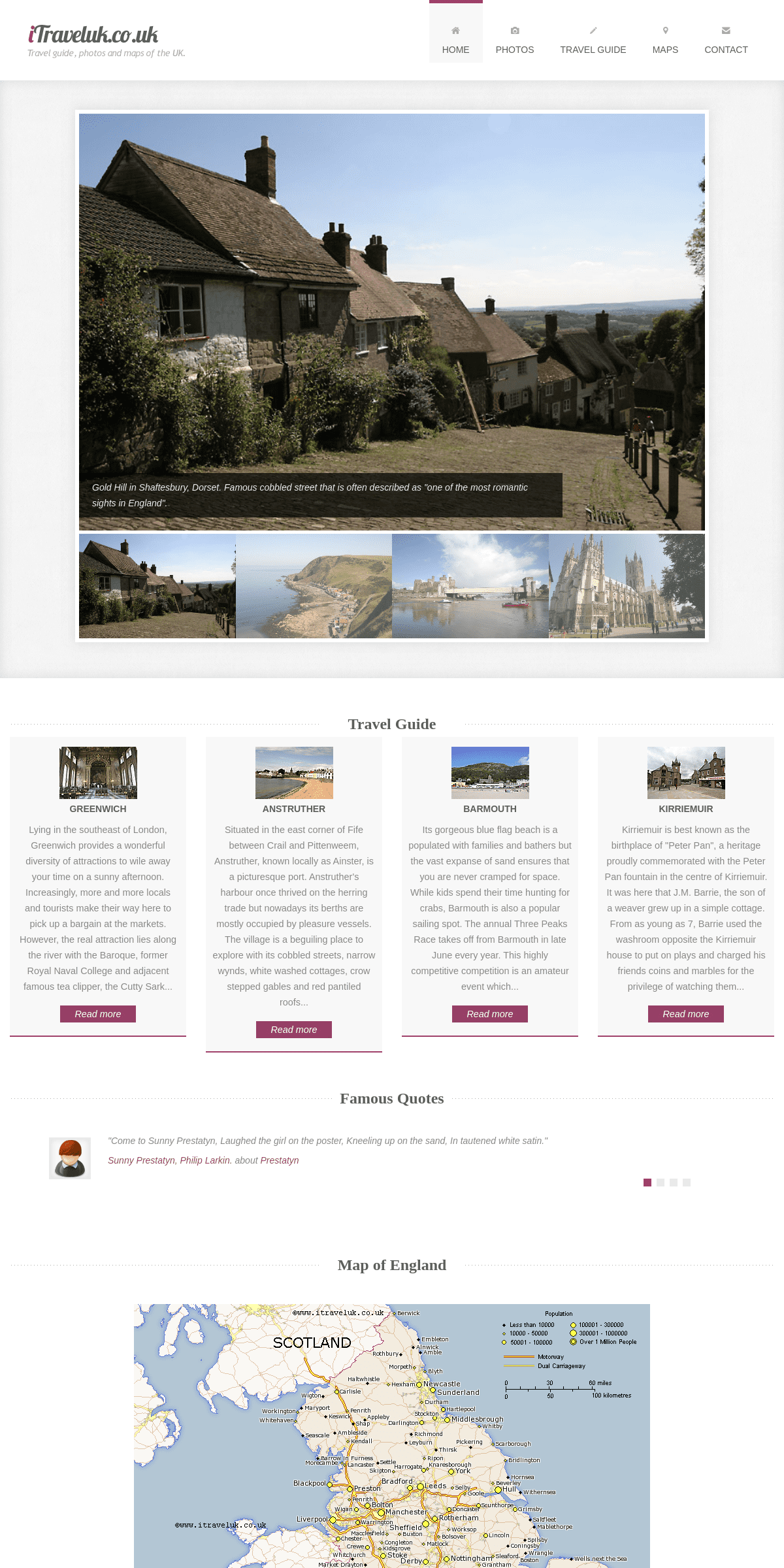
MAP OF ENGLAND
More maps of the UK can be found @ UK maps . All maps are copyright www.itraveluk.co.uk and no map including this England map can be used on anyother website. These maps can be used for offline use for schoolprojects.
ABOUT
Welcome to my mainly photo and map site of England, Wales and Scotland. There are a few town guides written mostly about the South of England, Scotland and Wales.PHOTO GALLERY
*
*
*
*
*
*
*
*
MAPS
*
*
*
*
All maps, photos and text © www.itraveluk.co.uk. :: Country MapsDetails
4