4
More Annotations


5


3
Favourite Annotations


5


1
Text
THEMAS - WATERINFO
Themas. FLOOD \ Current Situation Normal. Flood Normal. Current Situation. Short term predictions: 48h. Long term prediction: 10 days. More information. CurrentREPORTS - WATERINFO
This is an official website of the Flemish government More info NL FREN
WATERTOETS - WATERINFO Selecteer een perceel door te klikken op de kaart. Hierna krijg je een overzicht van de gegevens die je kan afprinten in een pdf document. Zoeken via perceelnummer. Source : AGIV. Zoom to GPS coordinates : X : Y : Zoom to Lambert coordinates : X : WEGWIJS OP DE WEBSITE Watch the instructional video on Youtube. Use the cc and Settings buttons on the right to select English subtitles. A dedicated website reserved for emergency services: pro.waterinfo.beKAARTENCATALOGUS
This is an official website of the Flemish government More info NL FREN
WATERINFO.BE
WATERINFO.be
RAADPLEGEN - WATERINFO 20. 40km. Map reports of historical hydrological data can be selected on this page. These maps display various data such as interpolated rainfall (deficit), temperature measurements, wind speed, etc. Daily map reports are generated automatically. Map reports that display the situation of the past months or years, are published after a manual AANMELDEN - WATERINFO Aanmelden. E-mail. Password. Forgot it? No account yet? Create onehere!
STATION
Station Station
GEOSERVER: WELCOME
This GeoServer instance is running version 2.16.2.For more information please contact the administrator.THEMAS - WATERINFO
Themas. FLOOD \ Current Situation Normal. Flood Normal. Current Situation. Short term predictions: 48h. Long term prediction: 10 days. More information. CurrentREPORTS - WATERINFO
This is an official website of the Flemish government More info NL FREN
WATERTOETS - WATERINFO Selecteer een perceel door te klikken op de kaart. Hierna krijg je een overzicht van de gegevens die je kan afprinten in een pdf document. Zoeken via perceelnummer. Source : AGIV. Zoom to GPS coordinates : X : Y : Zoom to Lambert coordinates : X : WEGWIJS OP DE WEBSITE Watch the instructional video on Youtube. Use the cc and Settings buttons on the right to select English subtitles. A dedicated website reserved for emergency services: pro.waterinfo.beKAARTENCATALOGUS
This is an official website of the Flemish government More info NL FREN
WATERINFO.BE
WATERINFO.be
RAADPLEGEN - WATERINFO 20. 40km. Map reports of historical hydrological data can be selected on this page. These maps display various data such as interpolated rainfall (deficit), temperature measurements, wind speed, etc. Daily map reports are generated automatically. Map reports that display the situation of the past months or years, are published after a manual AANMELDEN - WATERINFO Aanmelden. E-mail. Password. Forgot it? No account yet? Create onehere!
STATION
Station Station
GEOSERVER: WELCOME
This GeoServer instance is running version 2.16.2.For more information please contact the administrator.REPORTS - WATERINFO
This is an official website of the Flemish government More info NL FREN
WATERTOETS - WATERINFO Selecteer een perceel door te klikken op de kaart. Hierna krijg je een overzicht van de gegevens die je kan afprinten in een pdf document. Zoeken via perceelnummer. Source : AGIV. Zoom to GPS coordinates : X : Y : Zoom to Lambert coordinates : X : RAADPLEGEN - WATERINFO 20. 40km. Map reports of historical hydrological data can be selected on this page. These maps display various data such as interpolated rainfall (deficit), temperature measurements, wind speed, etc. Daily map reports are generated automatically. Map reports that display the situation of the past months or years, are published after a manualKAARTENCATALOGUS
This is an official website of the Flemish government More info NL FREN
RAPPORTEN - WATERINFO This page lists reports and publications from the waterinfo partners. METINGEN METEOROLOGIE Map reports of historical meteorological data can be selected on this page. These maps display various data such as interpolated rainfall (deficit), temperature measurements, wind speed, etc. HELPDESK - WATERINFO About waterinfo.be. Waterinfo.be is a website of the Flemish government: Read more This is an official website of the Flemishgovernment
DROUGHT STATUS WATERCOURSES Only show filters button (no column with filters in desktop) ShowTags. Apply
WOORDENLIJST
STF: On the graphs of the forecasts, the abbreviation 'STV' stands for the start time of the forecast (starttijd van de voorspelling). This is the time at which the computer model started computing, using the most recent measurements and rainfall forecasts available at thattime.
WATERINFO.BE
WATERINFO.be
REPORTS - WATERINFO
This is an official website of the Flemish government More info NL FREN
HELPDESK - WATERINFO Graphs. Clicking on the points indicated on the map will open the corresponding graphs in the graphs module.When you hover the mouse over a graph, four icons appear. These icons (from left to right) allow you to centre the location of the measuring point in the map, maximise the graph, add the graph to your favourites, or delete the graph from the module. WATERTOETS - WATERINFO This is an official website of the Flemish government More info NL FREN
THEMAS - WATERINFO
This is an official website of the Flemish government More info NL FREN
WATERINFO.BE
WATERINFO.be
KAARTENCATALOGUS
This is an official website of the Flemish government More info NL FREN
WEGWIJS OP DE WEBSITE Watch the instructional video on Youtube. Use the cc and Settings buttons on the right to select English subtitles. A dedicated website reserved for emergency services: pro.waterinfo.beWOORDENLIJST
STF: On the graphs of the forecasts, the abbreviation 'STV' stands for the start time of the forecast (starttijd van de voorspelling). This is the time at which the computer model started computing, using the most recent measurements and rainfall forecasts available at thattime.
RAADPLEGEN - WATERINFO Map reports of historical hydrological data can be selected on this page. These maps display various data such as interpolated rainfall (deficit), temperature measurements, wind speed, etc. Daily map reports are generated automatically.STATION
Station Station
REPORTS - WATERINFO
This is an official website of the Flemish government More info NL FREN
HELPDESK - WATERINFO Graphs. Clicking on the points indicated on the map will open the corresponding graphs in the graphs module.When you hover the mouse over a graph, four icons appear. These icons (from left to right) allow you to centre the location of the measuring point in the map, maximise the graph, add the graph to your favourites, or delete the graph from the module. WATERTOETS - WATERINFO This is an official website of the Flemish government More info NL FREN
THEMAS - WATERINFO
This is an official website of the Flemish government More info NL FREN
WATERINFO.BE
WATERINFO.be
KAARTENCATALOGUS
This is an official website of the Flemish government More info NL FREN
WEGWIJS OP DE WEBSITE Watch the instructional video on Youtube. Use the cc and Settings buttons on the right to select English subtitles. A dedicated website reserved for emergency services: pro.waterinfo.beWOORDENLIJST
STF: On the graphs of the forecasts, the abbreviation 'STV' stands for the start time of the forecast (starttijd van de voorspelling). This is the time at which the computer model started computing, using the most recent measurements and rainfall forecasts available at thattime.
WATERTOETS - WATERINFO This is an official website of the Flemish government More info NL FREN
WATERTOETS - WATERINFOTRANSLATE THIS PAGE Dit is een officiële website van de Vlaamse overheid Meer info NL FREN
WATERINFO.BE
WATERINFO.be
MORE INFO
Introduction. The Flood theme provides information about current and forecasted flooding in Flanders. The information shown on the map varies according to the sub-theme. RAPPORTEN - WATERINFO This page lists reports and publications from the waterinfo partners. RAADPLEGEN - WATERINFO Map reports of historical hydrological data can be selected on this page. These maps display various data such as interpolated rainfall (deficit), temperature measurements, wind speed, etc. Daily map reports are generated automatically. HELPDESK - WATERINFO About waterinfo.be. Waterinfo.be is a website of the Flemish government: Read more This is an official website of the Flemishgovernment
METINGEN METEOROLOGIE Map reports of historical meteorological data can be selected on this page. These maps display various data such as interpolated rainfall (deficit), temperature measurements, wind speed, etc.VHA.WATERINFO.BE
Created Date: 1/17/2017 2:23:43 PMVHA.WATERINFO.BE
Created Date: 1/17/2017 3:35:57 PMTHEMAS - WATERINFO
Themas. FLOOD \ Current Situation Normal. Flood Normal. Current Situation. Short term predictions: 48h. Long term prediction: 10 days. More information. CurrentREPORTS - WATERINFO
This is an official website of the Flemish government More info NL FREN
WATERTOETS - WATERINFO Selecteer een perceel door te klikken op de kaart. Hierna krijg je een overzicht van de gegevens die je kan afprinten in een pdf document. Zoeken via perceelnummer. Source : AGIV. Zoom to GPS coordinates : X : Y : Zoom to Lambert coordinates : X : HELPDESK - WATERINFO Graphs. Clicking on the points indicated on the map will open the corresponding graphs in the graphs module.When you hover the mouse over a graph, four icons appear. These icons (from left to right) allow you to centre the location of the measuring point in the map, maximise the graph, add the graph to your favourites, or delete the graph from the module.WATERINFO.BE
WATERINFO.be
WEGWIJS OP DE WEBSITE Watch the instructional video on Youtube. Use the cc and Settings buttons on the right to select English subtitles. A dedicated website reserved for emergency services: pro.waterinfo.be RAADPLEGEN - WATERINFO 20. 40km. Map reports of historical hydrological data can be selected on this page. These maps display various data such as interpolated rainfall (deficit), temperature measurements, wind speed, etc. Daily map reports are generated automatically. Map reports that display the situation of the past months or years, are published after a manual STATION - WATERINFO.BE Station - waterinfo.be StationWOORDENLIJST
STF: On the graphs of the forecasts, the abbreviation 'STV' stands for the start time of the forecast (starttijd van de voorspelling). This is the time at which the computer model started computing, using the most recent measurements and rainfall forecasts available at thattime.
AANMELDEN - WATERINFO Aanmelden. E-mail. Password. Forgot it? No account yet? Create onehere!
THEMAS - WATERINFO
Themas. FLOOD \ Current Situation Normal. Flood Normal. Current Situation. Short term predictions: 48h. Long term prediction: 10 days. More information. CurrentREPORTS - WATERINFO
This is an official website of the Flemish government More info NL FREN
WATERTOETS - WATERINFO Selecteer een perceel door te klikken op de kaart. Hierna krijg je een overzicht van de gegevens die je kan afprinten in een pdf document. Zoeken via perceelnummer. Source : AGIV. Zoom to GPS coordinates : X : Y : Zoom to Lambert coordinates : X : HELPDESK - WATERINFO Graphs. Clicking on the points indicated on the map will open the corresponding graphs in the graphs module.When you hover the mouse over a graph, four icons appear. These icons (from left to right) allow you to centre the location of the measuring point in the map, maximise the graph, add the graph to your favourites, or delete the graph from the module.WATERINFO.BE
WATERINFO.be
WEGWIJS OP DE WEBSITE Watch the instructional video on Youtube. Use the cc and Settings buttons on the right to select English subtitles. A dedicated website reserved for emergency services: pro.waterinfo.be RAADPLEGEN - WATERINFO 20. 40km. Map reports of historical hydrological data can be selected on this page. These maps display various data such as interpolated rainfall (deficit), temperature measurements, wind speed, etc. Daily map reports are generated automatically. Map reports that display the situation of the past months or years, are published after a manual STATION - WATERINFO.BE Station - waterinfo.be StationWOORDENLIJST
STF: On the graphs of the forecasts, the abbreviation 'STV' stands for the start time of the forecast (starttijd van de voorspelling). This is the time at which the computer model started computing, using the most recent measurements and rainfall forecasts available at thattime.
AANMELDEN - WATERINFO Aanmelden. E-mail. Password. Forgot it? No account yet? Create onehere!
MORE INFO
These can be maximised to access more details. At the top right of the map, through the icon, you can see which map layers are available. The icon provides more information about these layers. At the bottom of the map, using the icon, you can expand the legend. It explains which symbols are used in the map. You can use the search bar at the top WATERTOETS - WATERINFOTRANSLATE THIS PAGE Dit is een officiële website van de Vlaamse overheid Meer info NL FREN
WATERTOETS - WATERINFO Selecteer een perceel door te klikken op de kaart. Hierna krijg je een overzicht van de gegevens die je kan afprinten in een pdf document. Zoeken via perceelnummer. Source : AGIV. Zoom to GPS coordinates : X : Y : Zoom to Lambert coordinates : X : RAADPLEGEN - WATERINFO 20. 40km. Map reports of historical hydrological data can be selected on this page. These maps display various data such as interpolated rainfall (deficit), temperature measurements, wind speed, etc. Daily map reports are generated automatically. Map reports that display the situation of the past months or years, are published after a manualWATERINFO.BE
WATERINFO.be
RAPPORTEN - WATERINFO This page lists reports and publications from the waterinfo partners. METINGEN METEOROLOGIE Map reports of historical meteorological data can be selected on this page. These maps display various data such as interpolated rainfall (deficit), temperature measurements, wind speed, etc. HELPDESK - WATERINFO About waterinfo.be. Waterinfo.be is a website of the Flemish government: Read more This is an official website of the Flemishgovernment
VHA.WATERINFO.BE
Created Date: 1/17/2017 2:23:43 PMVHA.WATERINFO.BE
Created Date: 1/17/2017 3:35:57 PMREPORTS - WATERINFO
This is an official website of the Flemish government More info NL FREN
WATERTOETS - WATERINFO Selecteer een perceel door te klikken op de kaart. Hierna krijg je een overzicht van de gegevens die je kan afprinten in een pdf document. Zoeken via perceelnummer. Source : AGIV. Zoom to GPS coordinates : X : Y : Zoom to Lambert coordinates : X : RAADPLEGEN - WATERINFO 20. 40km. Map reports of historical hydrological data can be selected on this page. These maps display various data such as interpolated rainfall (deficit), temperature measurements, wind speed, etc. Daily map reports are generated automatically. Map reports that display the situation of the past months or years, are published after a manual WATERTOETS - WATERINFOTRANSLATE THIS PAGE Dit is een officiële website van de Vlaamse overheid Meer info NL FREN
WEGWIJS OP DE WEBSITE Watch the instructional video on Youtube. Use the cc and Settings buttons on the right to select English subtitles. A dedicated website reserved for emergency services: pro.waterinfo.be RAPPORTEN - WATERINFO This page lists reports and publications from the waterinfo partners.WATERINFO.BE
WATERINFO.be
STATION - WATERINFO.BE Station - waterinfo.be Station METINGEN METEOROLOGIE Map reports of historical meteorological data can be selected on this page. These maps display various data such as interpolated rainfall (deficit), temperature measurements, wind speed, etc. AANMELDEN - WATERINFO Aanmelden. E-mail. Password. Forgot it? No account yet? Create onehere!
REPORTS - WATERINFO
This is an official website of the Flemish government More info NL FREN
WATERTOETS - WATERINFOTRANSLATE THIS PAGE Dit is een officiële website van de Vlaamse overheid Meer info NL FREN
WATERTOETS - WATERINFO Selecteer een perceel door te klikken op de kaart. Hierna krijg je een overzicht van de gegevens die je kan afprinten in een pdf document. Zoeken via perceelnummer. Source : AGIV. Zoom to GPS coordinates : X : Y : Zoom to Lambert coordinates : X :WATERINFO.BE
This is an official website of the Flemish government More info NL FREN
STATION - WATERINFO.BE Station - waterinfo.be Station HELPDESK - WATERINFO About waterinfo.be. Waterinfo.be is a website of the Flemish government: Read more This is an official website of the Flemishgovernment
MEER INFO: GETIJ
The water levels at the coast and in the Scheldt tidal zone are continuously measured. Under current situation you will find the latest measurements. Under tidal graphs you can view measurements from different locations in the same area (e.g. Lower Sea Scheldt river or Durme) in the form of a single clear graph. The values can be read simply by moving the mouse over the graph.WOORDENLIJST
STF: On the graphs of the forecasts, the abbreviation 'STV' stands for the start time of the forecast (starttijd van de voorspelling). This is the time at which the computer model started computing, using the most recent measurements and rainfall forecasts available at thattime.
METINGEN FYSISCHE PARAMETERS Real time measurements of fysical parameters can be found on this page. Read more This is an official website of the Flemish governmentWATERINFO.BE
WATERINFO.be
VLAANDEREN.be Waterinfo.beWATERINFO.BE
Vlaanderen
is water
PERS nl Nederlands nl Nederlands fr Frans en Engelslogin
Vergeten?
Maak een account aan.*
* Actuele toestand
* Voorspelde toestand - korte termijn * Voorspelde toestand - lange termijn*
* Actuele toestand tijgebied * Voorspelde toestand - korte termijn*
* Actuele toestand neerslag * Voorspelde toestand - korte termijn*
* Actuele droogtetoestand * Voorspelde toestand - lange termijn* Geoloket
* Metingen
* Raadplegen
* Metingen Meteorologie * Metingen Fysische parameters * Recentste waardes waterwegen* Downloaden
* Rapporten
* Over waterinfo.be
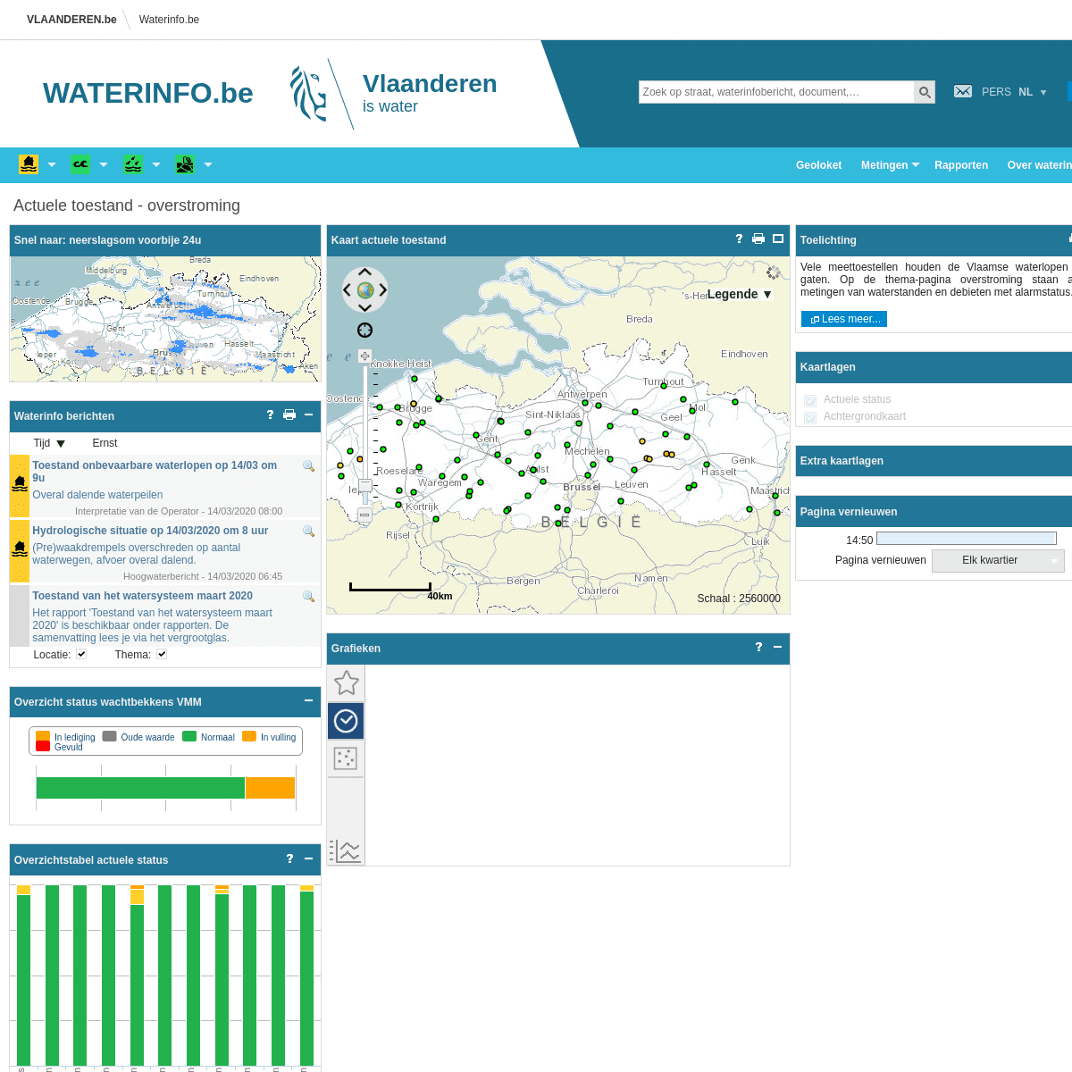
Actuele toestand - overstroming Snel naar: neerslagvoorspelling +48uWaterinfo berichten
Tijd Ernst
Toestand onbevaarbare waterlopen op 14/03 om 9u Overal dalende waterpeilen Interpretatie van de Operator - 14/03/2020 08:00 Hydrologische situatie op 14/03/2020 om 8 uur (Pre)waakdrempels overschreden op aantal waterwegen, afvoer overaldalend.
Hoogwaterbericht - 14/03/2020 06:45 Toestand van het watersysteem maart 2020 Het rapport 'Toestand van het watersysteem maart 2020' is beschikbaar onder rapporten. De samenvatting lees je via het vergrootglas. Nieuwsbericht - 10/03/2020 04:30 Storm Ciara - februari 2020: De Scheldeflits Storm Ciara zorgde voor 3 opeenvolgende stormtijen in het tijgebied van de Schelde. Klik op het vergrootglas voor de Scheldeflits! Nieuwsbericht - 17/02/2020 11:00 Open (radar)data voor waterinfo.be Het rapport "Open data voor waterinfo.be" werd uitgebreid voor de databank van MOW-WL. De samenvatting lees je via het vergrootglas. Nieuwsbericht - 17/09/2019 13:00 Astronomische voorspellingen 2020 beschikbaar Op de downloadpagina zijn de astronomische voorspellingen voor het tijgebied van de Schelde 2020 nu beschikbaar. Nieuwsbericht - 17/06/2019 09:00Locatie:
Thema:
Overzicht status wachtbekkens VMM Created with Highstock 1.3.7In ledigingOude waardeNormaalInvullingGevuld
Overzichtstabel actuele status Created with Highstock 1.3.7ValuesOude waardeGeen dataNormaalPrewaakWaakAlarmBekken Brugse poldersBekken Gentse kanalenBeneden-ScheldebekkenBoven-ScheldebekkenDemerbekkenDenderbekkenDijlebekkenIjzerbekkenLeiebekkenMaasbekkenNetebekken0100255075Toelichting
Vele meettoestellen houden de Vlaamse waterlopen in de gaten. Op de thema-pagina overstroming staan actuele metingen van waterstanden en debieten met alarmstatus.Lees meer...
Kaartlagen
- Feature lagen
*
Actuele status
*
Waterstand/afvoer
*
Status wachtbekkens VMM * Operationele lagen- Basis lagen
*
Achtergrondkaart
Extra kaartlagen
Pagina vernieuwen
14:44
Pagina vernieuwen Elk kwartierselectElke 5 minutenElk kwartierNooit Kaart actuele toestandSchaal : 2560000
LEGENDE ▼
Zoomen naar
+
-
0
20
40km
Grafieken
Dit is een officiële website van de Vlaamse overheidMeer info
Verberg info
WATERINFO.BE IS EEN OFFICIËLE WEBSITE VAN DE VLAAMSE OVERHEIDgepubliceerd door
de Vlaamse Milieumaatschappij, Waterbouwkundig Laboratorium, Maritieme Dienstverlening & Kust en De Vlaamse Waterweg NV Nieuwsgierig naar de (water)stand van zaken? Waterinfo.be informeert je met gedetailleerde kaarten en grafieken over vier grote thema’s neerslag, droogte, getijden en overstromingen* Over Waterinfo.be
* Disclaimer
* Privacy
* Cookieverklaring
* Toegankelijkheid
* Elke 5 minuten
* Elk kwartier
* Nooit
Details
6