2
More Annotations


6


4
Favourite Annotations


6


6
Text
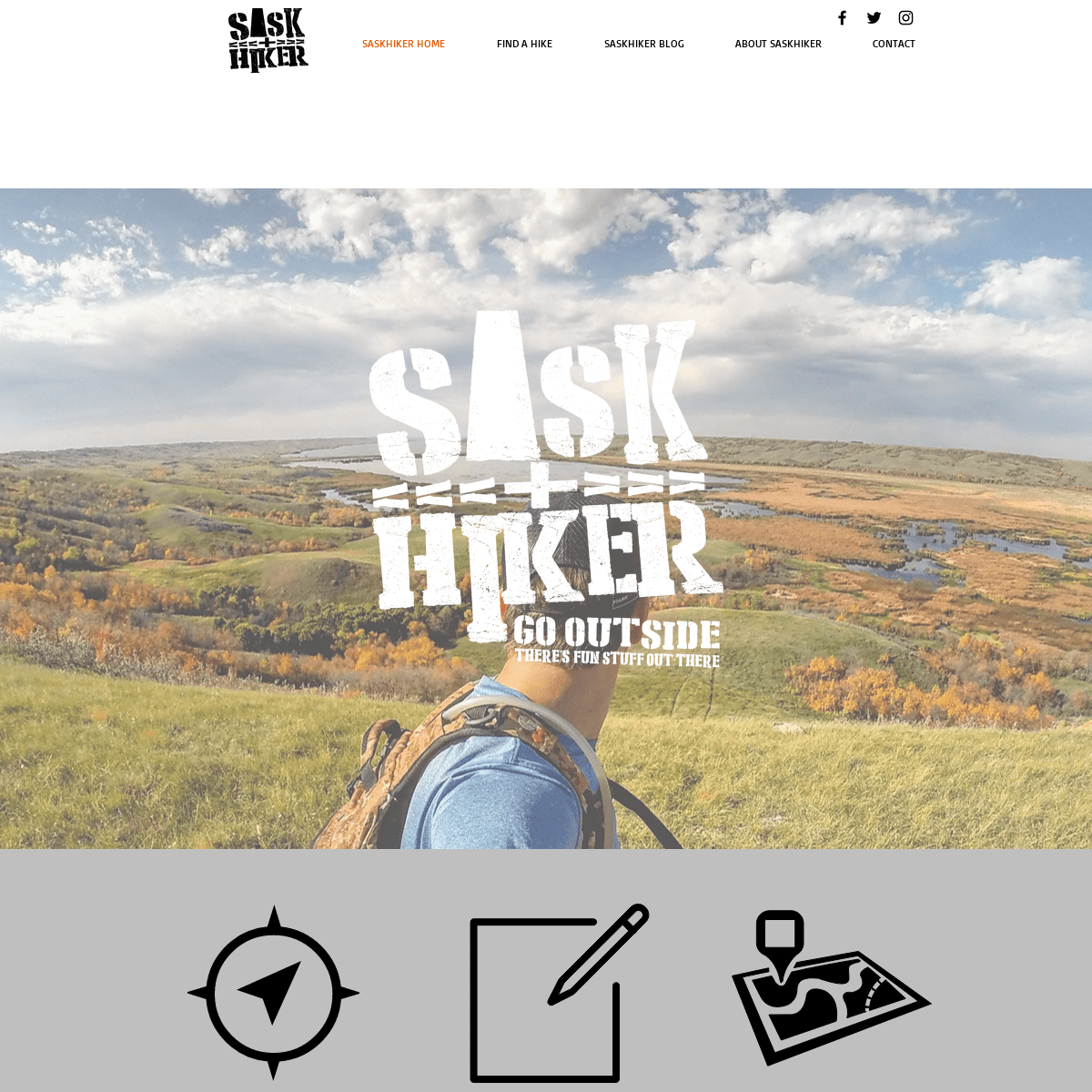
SASKATCHEWAN HIKING AND OUTDOOR ADVENTURESFIND A HIKEABOUT SASKHIKERCONTACTTHE GREAT SANDHILLSSASKHIKER LOCATION MAP Saskatchewan Hiking and Outdoor Adventures. Looking for an outdoor adventure in Saskatchewan? SaskHiker provides tips, maps and locations to make the most of your Saskatchewan hike. Follow SaskHiker for Updates on Adventures.
THE GREAT SANDHILLS
There are two routes to get to the Great Sandhills, either by Highway 21 or Highway 32. Highway 21 is in much better condition but only take this route if you are coming from the north. 1) Highway 21 coming from the north. Head south on Highway 21, when you hit Leader mark your distance your odometer. Exactly 25km from Leader you will take a BEAVER CREEK HIKING INFORMATION It can be quite busy on weekends, so prepare to share the trail with other people looking to escape the city. In the winter the Beaver Creek bed freezes entirely which allows you to walk along the meandering creek. Do not head out onto the ice of the South Saskatchewan River as it is dangerous and unstable. They do not allowdogs here, so if
GEM LAKES NARROW HILLS PROVINCIAL PARK HIKING INFORMATION One of Saskatchewan's best and most interesting trails is the Gem Lakes hike at Narrow Hills Provincial Park. This 5.5 kilometre trail that interwines itself with the Gem Lakes is a must visit for any hiker in the province. The Gem Lakes were formed during the last ice age where they were carved about by glaciers. CANDLE LAKE PROVINCIAL PARK HIKING TIPS Diffculty - Easy. This hike takes you through all the ecozones that Candle Lake offers such as dense forest, moss beds and wetlands. Be prepared for mosquitos in the summer! In June the trail can be almost unusasble due to the amount of mosquitos. The trailhead is MEADOW LAKE PROVINCIAL PARK HIKING MEADOW LAKE PROVINCIAL PARK. Meadow Lake Provincial Park is in my opinion one of the best parks in the entire province. The reasons being that this park is the most rustic and one of the least commercialized. The connection to nature is strong here. The other main reason is that this park contains our largest hiking trail the120km Boreal Trail
SASKATOON NORTHEAST SWALE HIKING You will see signs that desginate the Northeast Swale. There are two ways to get to the Northeast Swale and from there find a place to park on the side of the road where there is a fence opening. 1) Get onto Central Ave and head north, the road will turn into a gravel road. You will see the entrance to the swale and a small parking lot on the CLARENCE - STEEPBANK LAKES PROVINCIAL WILDERNESS PARK Of the two, Clarence is the most “modern” and easily accessible as it is only 500m from the park entrance. Clarence has a campground with 5 large campsites with firepits and an outhouse. The road to Clarence is wide enough to squeeze a small camper through. If you’re lookingfor
CROOKED BUSH INFORMATION CROOKED BUSH. Crooked Bush near Hafford, Saskatchewan is a small grove of aspen trees that have developed a genetic mutation that makes them grow in a very interesting way. You can only find these trees in this one specific spot in the world making them extremely rare and special.CHIEF WHITECAP PARK
The Chief Whitecap Park is located south of Saskatoon and is a nature area that allows visitors to explore the Saskatchewan River bank. Whitecap Park is a popular place for people to bring their dogs and let them run offleash, so if you have a furry friend bring him SASKATCHEWAN HIKING AND OUTDOOR ADVENTURESFIND A HIKEABOUT SASKHIKERCONTACTTHE GREAT SANDHILLSSASKHIKER LOCATION MAP Saskatchewan Hiking and Outdoor Adventures. Looking for an outdoor adventure in Saskatchewan? SaskHiker provides tips, maps and locations to make the most of your Saskatchewan hike. Follow SaskHiker for Updates on Adventures.THE GREAT SANDHILLS
There are two routes to get to the Great Sandhills, either by Highway 21 or Highway 32. Highway 21 is in much better condition but only take this route if you are coming from the north. 1) Highway 21 coming from the north. Head south on Highway 21, when you hit Leader mark your distance your odometer. Exactly 25km from Leader you will take a BEAVER CREEK HIKING INFORMATION It can be quite busy on weekends, so prepare to share the trail with other people looking to escape the city. In the winter the Beaver Creek bed freezes entirely which allows you to walk along the meandering creek. Do not head out onto the ice of the South Saskatchewan River as it is dangerous and unstable. They do not allowdogs here, so if
GEM LAKES NARROW HILLS PROVINCIAL PARK HIKING INFORMATION One of Saskatchewan's best and most interesting trails is the Gem Lakes hike at Narrow Hills Provincial Park. This 5.5 kilometre trail that interwines itself with the Gem Lakes is a must visit for any hiker in the province. The Gem Lakes were formed during the last ice age where they were carved about by glaciers. CANDLE LAKE PROVINCIAL PARK HIKING TIPS Diffculty - Easy. This hike takes you through all the ecozones that Candle Lake offers such as dense forest, moss beds and wetlands. Be prepared for mosquitos in the summer! In June the trail can be almost unusasble due to the amount of mosquitos. The trailhead is MEADOW LAKE PROVINCIAL PARK HIKING MEADOW LAKE PROVINCIAL PARK. Meadow Lake Provincial Park is in my opinion one of the best parks in the entire province. The reasons being that this park is the most rustic and one of the least commercialized. The connection to nature is strong here. The other main reason is that this park contains our largest hiking trail the120km Boreal Trail
SASKATOON NORTHEAST SWALE HIKING You will see signs that desginate the Northeast Swale. There are two ways to get to the Northeast Swale and from there find a place to park on the side of the road where there is a fence opening. 1) Get onto Central Ave and head north, the road will turn into a gravel road. You will see the entrance to the swale and a small parking lot on the CLARENCE - STEEPBANK LAKES PROVINCIAL WILDERNESS PARK Of the two, Clarence is the most “modern” and easily accessible as it is only 500m from the park entrance. Clarence has a campground with 5 large campsites with firepits and an outhouse. The road to Clarence is wide enough to squeeze a small camper through. If you’re lookingfor
CROOKED BUSH INFORMATION CROOKED BUSH. Crooked Bush near Hafford, Saskatchewan is a small grove of aspen trees that have developed a genetic mutation that makes them grow in a very interesting way. You can only find these trees in this one specific spot in the world making them extremely rare and special.CHIEF WHITECAP PARK
The Chief Whitecap Park is located south of Saskatoon and is a nature area that allows visitors to explore the Saskatchewan River bank. Whitecap Park is a popular place for people to bring their dogs and let them run offleash, so if you have a furry friend bring himFIND A HIKE
A part of Canada's massive boreal forest, northern Saskatchewan largely untouched and wild. The further north you go, the smaller the population and more alien the landscape. You will find towering pines and birch trees. Massive untouched lakes, rivers and streams. Summer can be very bad for blackflies and mosquito's so bring lots ofbugspray
CENTRAL SASKATCHEWAN The trailhead starts in the town of Outlook and follows the South Saskatchewan River. This Saskatchewan hike is a part of the TransCanada Trail and is most famous for the SkyTrail Bridge. A 48 meter tall bridge that is the longest pedestrian bridge in Canada. One of SaskHiker's more favourite locations in the province! CANDLE LAKE PROVINCIAL PARK HIKING TIPS Diffculty - Easy. This hike takes you through all the ecozones that Candle Lake offers such as dense forest, moss beds and wetlands. Be prepared for mosquitos in the summer! In June the trail can be almost unusasble due to the amount of mosquitos. The trailhead is GRASSLANDS NATIONAL PARK HIKING The best time to visit is in May and June when the grasslands are in full bloom with flowers. The Grasslands National Park has many native plants that are harder to find in other parts of the province. Hiking in the Grasslands National Park will be like no other hike in the province. Make sure you are carrying adequate water, are carrying a MEADOW LAKE PROVINCIAL PARK HIKING MEADOW LAKE PROVINCIAL PARK. Meadow Lake Provincial Park is in my opinion one of the best parks in the entire province. The reasons being that this park is the most rustic and one of the least commercialized. The connection to nature is strong here. The other main reason is that this park contains our largest hiking trail the120km Boreal Trail
SASKATOON NORTHEAST SWALE HIKING You will see signs that desginate the Northeast Swale. There are two ways to get to the Northeast Swale and from there find a place to park on the side of the road where there is a fence opening. 1) Get onto Central Ave and head north, the road will turn into a gravel road. You will see the entrance to the swale and a small parking lot on the DUCK MOUNTAIN PROVINCIAL PARK HIKING Duck Mountain Provincial Park is situated in the southern limit of Saskatchewan’s boreal forest. The area has a unique geography- carved out by the last ice age and rising over 650 ft above the surrounding lowlands. Here you will find a brilliant mix of flora and fauna, including rare carnivorous plants in the parks southernextremity.
DOUGLAS PROVINCIAL PARK HIKING TRAILS Douglas Provincial Park is located on Highway 19 on the southend of Lake Diefenbaker. The road into the park can be quite rough so keep an eye out for potholes. The trailhead for the TransCanada Trail is located at the main beach by the laundromat. The trailhead for the dunes are located at the Dunes Nature Centre that is across thehighway
CHIEF WHITECAP PARK
The Chief Whitecap Park is located south of Saskatoon and is a nature area that allows visitors to explore the Saskatchewan River bank. Whitecap Park is a popular place for people to bring their dogs and let them run offleash, so if you have a furry friend bring BUFFALO POUND PROVINCIAL PARK HIKING Buffalo Pound Provincial Park is a place bursting with activity. You will find numerous things to do here such as hiking, mountain biking, camping, boating and fishing. The park is nestled in the Qu'Appelle Valley and borders Buffalo Pound Lake and the Qu'Appelle and Moose Jaw Rivers. The area used to be an important buffalo hunting ground for SASKATCHEWAN HIKING AND OUTDOOR ADVENTURESFIND A HIKEABOUT SASKHIKERCONTACTTHE GREAT SANDHILLSSASKHIKER LOCATION MAP Saskatchewan Hiking and Outdoor Adventures. Looking for an outdoor adventure in Saskatchewan? SaskHiker provides tips, maps and locations to make the most of your Saskatchewan hike. Follow SaskHiker for Updates on Adventures. BEAVER CREEK HIKING INFORMATION It can be quite busy on weekends, so prepare to share the trail with other people looking to escape the city. In the winter the Beaver Creek bed freezes entirely which allows you to walk along the meandering creek. Do not head out onto the ice of the South Saskatchewan River as it is dangerous and unstable. They do not allowdogs here, so if
GEM LAKES NARROW HILLS PROVINCIAL PARK HIKING INFORMATION One of Saskatchewan's best and most interesting trails is the Gem Lakes hike at Narrow Hills Provincial Park. This 5.5 kilometre trail that interwines itself with the Gem Lakes is a must visit for any hiker in the province. The Gem Lakes were formed during the last ice age where they were carved about by glaciers.THE GREAT SANDHILLS
There are two routes to get to the Great Sandhills, either by Highway 21 or Highway 32. Highway 21 is in much better condition but only take this route if you are coming from the north. 1) Highway 21 coming from the north. Head south on Highway 21, when you hit Leader mark your distance your odometer. Exactly 25km from Leader you will take a CANDLE LAKE PROVINCIAL PARK HIKING TIPS Diffculty - Easy. This hike takes you through all the ecozones that Candle Lake offers such as dense forest, moss beds and wetlands. Be prepared for mosquitos in the summer! In June the trail can be almost unusasble due to the amount of mosquitos. The trailhead is CLARENCE - STEEPBANK LAKES PROVINCIAL WILDERNESS PARK Of the two, Clarence is the most “modern” and easily accessible as it is only 500m from the park entrance. Clarence has a campground with 5 large campsites with firepits and an outhouse. The road to Clarence is wide enough to squeeze a small camper through. If you’re lookingfor
CROOKED BUSH INFORMATION CROOKED BUSH. Crooked Bush near Hafford, Saskatchewan is a small grove of aspen trees that have developed a genetic mutation that makes them grow in a very interesting way. You can only find these trees in this one specific spot in the world making them extremely rare and special. BUFFALO POUND PROVINCIAL PARK HIKING Buffalo Pound Provincial Park is a place bursting with activity. You will find numerous things to do here such as hiking, mountain biking, camping, boating and fishing. The park is nestled in the Qu'Appelle Valley and borders Buffalo Pound Lake and the Qu'Appelle and Moose Jaw Rivers. The area used to be an important buffalo hunting ground for LIST OF HIKING/OUTDOOR GROUPS IN SASKATCHEWAN I have been asked this question a thousand times - "Do you know of any hiking or outdoor groups in Saskatchewan?" and until now I had no answer. I figured if I asked the SaskHiker Community they would have the answer! And boy did they! I put a list together based on people's suggestions so hopefully more people can share the joys of hiking andbeing outdoors!
HOW TO CANOE FROM OUTLOOK TO SASKATOON Five friends and I recently spent 3 days on the stunning South Saskatchewan River where we paddled from Outlook to Saskatoon. This easy, pleasurable and rewarding paddle is the perfect trek for those just getting their feet wet into the world of canoeing. It is impossible to get lost as there is only one route to take, there is access to hundreds of fantastic beachside campsites and there are SASKATCHEWAN HIKING AND OUTDOOR ADVENTURESFIND A HIKEABOUT SASKHIKERCONTACTTHE GREAT SANDHILLSSASKHIKER LOCATION MAP Saskatchewan Hiking and Outdoor Adventures. Looking for an outdoor adventure in Saskatchewan? SaskHiker provides tips, maps and locations to make the most of your Saskatchewan hike. Follow SaskHiker for Updates on Adventures. BEAVER CREEK HIKING INFORMATION It can be quite busy on weekends, so prepare to share the trail with other people looking to escape the city. In the winter the Beaver Creek bed freezes entirely which allows you to walk along the meandering creek. Do not head out onto the ice of the South Saskatchewan River as it is dangerous and unstable. They do not allowdogs here, so if
GEM LAKES NARROW HILLS PROVINCIAL PARK HIKING INFORMATION One of Saskatchewan's best and most interesting trails is the Gem Lakes hike at Narrow Hills Provincial Park. This 5.5 kilometre trail that interwines itself with the Gem Lakes is a must visit for any hiker in the province. The Gem Lakes were formed during the last ice age where they were carved about by glaciers.THE GREAT SANDHILLS
There are two routes to get to the Great Sandhills, either by Highway 21 or Highway 32. Highway 21 is in much better condition but only take this route if you are coming from the north. 1) Highway 21 coming from the north. Head south on Highway 21, when you hit Leader mark your distance your odometer. Exactly 25km from Leader you will take a CANDLE LAKE PROVINCIAL PARK HIKING TIPS Diffculty - Easy. This hike takes you through all the ecozones that Candle Lake offers such as dense forest, moss beds and wetlands. Be prepared for mosquitos in the summer! In June the trail can be almost unusasble due to the amount of mosquitos. The trailhead is CLARENCE - STEEPBANK LAKES PROVINCIAL WILDERNESS PARK Of the two, Clarence is the most “modern” and easily accessible as it is only 500m from the park entrance. Clarence has a campground with 5 large campsites with firepits and an outhouse. The road to Clarence is wide enough to squeeze a small camper through. If you’re lookingfor
CROOKED BUSH INFORMATION CROOKED BUSH. Crooked Bush near Hafford, Saskatchewan is a small grove of aspen trees that have developed a genetic mutation that makes them grow in a very interesting way. You can only find these trees in this one specific spot in the world making them extremely rare and special. BUFFALO POUND PROVINCIAL PARK HIKING Buffalo Pound Provincial Park is a place bursting with activity. You will find numerous things to do here such as hiking, mountain biking, camping, boating and fishing. The park is nestled in the Qu'Appelle Valley and borders Buffalo Pound Lake and the Qu'Appelle and Moose Jaw Rivers. The area used to be an important buffalo hunting ground for LIST OF HIKING/OUTDOOR GROUPS IN SASKATCHEWAN I have been asked this question a thousand times - "Do you know of any hiking or outdoor groups in Saskatchewan?" and until now I had no answer. I figured if I asked the SaskHiker Community they would have the answer! And boy did they! I put a list together based on people's suggestions so hopefully more people can share the joys of hiking andbeing outdoors!
HOW TO CANOE FROM OUTLOOK TO SASKATOON Five friends and I recently spent 3 days on the stunning South Saskatchewan River where we paddled from Outlook to Saskatoon. This easy, pleasurable and rewarding paddle is the perfect trek for those just getting their feet wet into the world of canoeing. It is impossible to get lost as there is only one route to take, there is access to hundreds of fantastic beachside campsites and there areFIND A HIKE
A part of Canada's massive boreal forest, northern Saskatchewan largely untouched and wild. The further north you go, the smaller the population and more alien the landscape. You will find towering pines and birch trees. Massive untouched lakes, rivers and streams. Summer can be very bad for blackflies and mosquito's so bring lots ofbugspray
CENTRAL SASKATCHEWAN The trailhead starts in the town of Outlook and follows the South Saskatchewan River. This Saskatchewan hike is a part of the TransCanada Trail and is most famous for the SkyTrail Bridge. A 48 meter tall bridge that is the longest pedestrian bridge in Canada. One of SaskHiker's more favourite locations in the province! CANDLE LAKE PROVINCIAL PARK HIKING TIPS Diffculty - Easy. This hike takes you through all the ecozones that Candle Lake offers such as dense forest, moss beds and wetlands. Be prepared for mosquitos in the summer! In June the trail can be almost unusasble due to the amount of mosquitos. The trailhead is GRASSLANDS NATIONAL PARK HIKING The best time to visit is in May and June when the grasslands are in full bloom with flowers. The Grasslands National Park has many native plants that are harder to find in other parts of the province. Hiking in the Grasslands National Park will be like no other hike in the province. Make sure you are carrying adequate water, are carrying a CLARENCE - STEEPBANK LAKES PROVINCIAL WILDERNESS PARK Of the two, Clarence is the most “modern” and easily accessible as it is only 500m from the park entrance. Clarence has a campground with 5 large campsites with firepits and an outhouse. The road to Clarence is wide enough to squeeze a small camper through. If you’re lookingfor
DOUGLAS PROVINCIAL PARK HIKING TRAILS Douglas Provincial Park is located on Highway 19 on the southend of Lake Diefenbaker. The road into the park can be quite rough so keep an eye out for potholes. The trailhead for the TransCanada Trail is located at the main beach by the laundromat. The trailhead for the dunes are located at the Dunes Nature Centre that is across thehighway
CHIEF WHITECAP PARK
The Chief Whitecap Park is located south of Saskatoon and is a nature area that allows visitors to explore the Saskatchewan River bank. Whitecap Park is a popular place for people to bring their dogs and let them run offleash, so if you have a furry friend bring SASKATOON NORTHEAST SWALE HIKING You will see signs that desginate the Northeast Swale. There are two ways to get to the Northeast Swale and from there find a place to park on the side of the road where there is a fence opening. 1) Get onto Central Ave and head north, the road will turn into a gravel road. You will see the entrance to the swale and a small parking lot on the CROOKED BUSH INFORMATION CROOKED BUSH. Crooked Bush near Hafford, Saskatchewan is a small grove of aspen trees that have developed a genetic mutation that makes them grow in a very interesting way. You can only find these trees in this one specific spot in the world making them extremely rare and special. BUFFALO POUND PROVINCIAL PARK HIKING Buffalo Pound Provincial Park is a place bursting with activity. You will find numerous things to do here such as hiking, mountain biking, camping, boating and fishing. The park is nestled in the Qu'Appelle Valley and borders Buffalo Pound Lake and the Qu'Appelle and Moose Jaw Rivers. The area used to be an important buffalo hunting ground for SASKATCHEWAN HIKING AND OUTDOOR ADVENTURESFIND A HIKEABOUT SASKHIKERCONTACTTHE GREAT SANDHILLSSASKHIKER LOCATION MAP Saskatchewan Hiking and Outdoor Adventures Looking for an outdoor adventure in Saskatchewan? SaskHiker provides tips, maps and locations to make the most of your Saskatchewan hike. CANDLE LAKE PROVINCIAL PARK HIKING TIPS CANDLE LAKE PROVINCIAL PARK . Candle Lake Provincial Park borders the impressive lake of Candle Lake, situated northwest of Prince Albert, it is a short two and half hour drive from Saskatoon. BEAVER CREEK HIKING INFORMATION BEAVER CREEK CONSERVATION AREA . Looking for a day hike close to Saskatoon? Then Beaver Creek Conservation Area is a great place to head out for the day. GEM LAKES NARROW HILLS PROVINCIAL PARK HIKING INFORMATION GEM LAKES - NARROW HILLS PROVINCIAL PARK . One of Saskatchewan's best and most interesting trails is the Gem Lakes hike at Narrow HillsProvincial Park.
THE GREAT SANDHILLS
THE GREAT SANDHILLS . One of my favourite locations in the entire province, the The Great Sandhills are a place every person should visit! This park is one large nature preserve and one of Canada's largest active sand dune. CROOKED BUSH INFORMATION CROOKED BUSH . Crooked Bush near Hafford, Saskatchewan is a small grove of aspen trees that have developed a genetic mutation that makes them grow in a very interesting way. BUFFALO POUND PROVINCIAL PARK HIKING BUFFALO POUND PROVINCIAL PARK HIKING AND BIKING TRAILS . Buffalo Pound Provincial Park is a place bursting with activity. You will find numerous things to do here such as hiking, mountain biking, camping, boating and fishing.CHIEF WHITECAP PARK
CHIEF WHITECAP PARK TRAIL . The Meewasin Valley Authority just recently finished another section of trail that allows you to now hike or bike from the Circle South Bridge in Saskatoon to Chief WhitecapPark.
CLARENCE - STEEPBANK LAKES PROVINCIAL WILDERNESS PARK CLARENCE - STEEPBANK LAKES PROVINCIAL WILDERNESS PARK . If you are looking for a true off the grid experience Clarence - Steepbank Lakes Provincial Wilderness Park will be for you. HOW TO CANOE FROM OUTLOOK TO SASKATOON Five friends and I recently spent 3 days on the stunning South Saskatchewan River where we paddled from Outlook to Saskatoon. This easy, pleasurable and rewarding paddle is the perfect trek for those just getting their feet wet into the world of canoeing. It is impossible to get lost as there is only one route to take, there is access to hundreds of fantastic beachside campsites and there are SASKATCHEWAN HIKING AND OUTDOOR ADVENTURESFIND A HIKEABOUT SASKHIKERCONTACTTHE GREAT SANDHILLSSASKHIKER LOCATION MAP Saskatchewan Hiking and Outdoor Adventures Looking for an outdoor adventure in Saskatchewan? SaskHiker provides tips, maps and locations to make the most of your Saskatchewan hike. CANDLE LAKE PROVINCIAL PARK HIKING TIPS CANDLE LAKE PROVINCIAL PARK . Candle Lake Provincial Park borders the impressive lake of Candle Lake, situated northwest of Prince Albert, it is a short two and half hour drive from Saskatoon. BEAVER CREEK HIKING INFORMATION BEAVER CREEK CONSERVATION AREA . Looking for a day hike close to Saskatoon? Then Beaver Creek Conservation Area is a great place to head out for the day. GEM LAKES NARROW HILLS PROVINCIAL PARK HIKING INFORMATION GEM LAKES - NARROW HILLS PROVINCIAL PARK . One of Saskatchewan's best and most interesting trails is the Gem Lakes hike at Narrow HillsProvincial Park.
THE GREAT SANDHILLS
THE GREAT SANDHILLS . One of my favourite locations in the entire province, the The Great Sandhills are a place every person should visit! This park is one large nature preserve and one of Canada's largest active sand dune. CROOKED BUSH INFORMATION CROOKED BUSH . Crooked Bush near Hafford, Saskatchewan is a small grove of aspen trees that have developed a genetic mutation that makes them grow in a very interesting way. BUFFALO POUND PROVINCIAL PARK HIKING BUFFALO POUND PROVINCIAL PARK HIKING AND BIKING TRAILS . Buffalo Pound Provincial Park is a place bursting with activity. You will find numerous things to do here such as hiking, mountain biking, camping, boating and fishing.CHIEF WHITECAP PARK
CHIEF WHITECAP PARK TRAIL . The Meewasin Valley Authority just recently finished another section of trail that allows you to now hike or bike from the Circle South Bridge in Saskatoon to Chief WhitecapPark.
CLARENCE - STEEPBANK LAKES PROVINCIAL WILDERNESS PARK CLARENCE - STEEPBANK LAKES PROVINCIAL WILDERNESS PARK . If you are looking for a true off the grid experience Clarence - Steepbank Lakes Provincial Wilderness Park will be for you. HOW TO CANOE FROM OUTLOOK TO SASKATOON Five friends and I recently spent 3 days on the stunning South Saskatchewan River where we paddled from Outlook to Saskatoon. This easy, pleasurable and rewarding paddle is the perfect trek for those just getting their feet wet into the world of canoeing. It is impossible to get lost as there is only one route to take, there is access to hundreds of fantastic beachside campsites and there areFIND A HIKE
Southwest Saskatchewan . This region of the province is marked with sand dunes, rolling hills, natural grasslands, badlands and open spaces. You will find yourself taking a lot of breaks overlooking miles of open prairie while atop of a hill. GRASSLANDS NATIONAL PARK HIKING GRASSLANDS NATIONAL PARK HIKING . Grasslands National Park located in the south of Saskatchewn is one of the most unique and interesting geological locations in the province. GEM LAKES NARROW HILLS PROVINCIAL PARK HIKING INFORMATION GEM LAKES - NARROW HILLS PROVINCIAL PARK . One of Saskatchewan's best and most interesting trails is the Gem Lakes hike at Narrow HillsProvincial Park.
CENTRAL SASKATCHEWAN A day hike north of Saskatoon full of history. You will see views of the South Saskatchewan River, active archaeological dig sites and other First Nation history. NORTHERN SASKATCHEWAN HIKES Duck Mountain is situated in the most southern limit of Saskatchewan’s boreal forest. The area has a unique geography- carved out by the last ice age and rising over 650 ft above the surrounding lowlands. DOUGLAS PROVINCIAL PARK HIKING TRAILS DOUGLAS PROVINCIAL PARK HIKING TRAILS . Located on the shores of the mighty Lake Diefenbaker is the Douglas Provincial Park. This park has all the amenities that one wants when heading out for a weekend ofcamping and hiking.
BUFFALO POUND PROVINCIAL PARK HIKING BUFFALO POUND PROVINCIAL PARK HIKING AND BIKING TRAILS . Buffalo Pound Provincial Park is a place bursting with activity. You will find numerous things to do here such as hiking, mountain biking, camping, boating and fishing. SASKATOON NORTHEAST SWALE HIKING SASKATOON NORTHEAST SWALE . Natural Saskatchewan prairie unfortunatley is a hard thing to find in the province however you can find it within the Saskatoon city limits in CLARENCE - STEEPBANK LAKES PROVINCIAL WILDERNESS PARK CLARENCE - STEEPBANK LAKES PROVINCIAL WILDERNESS PARK . If you are looking for a true off the grid experience Clarence - Steepbank Lakes Provincial Wilderness Park will be for you. HOW TO CANOE FROM OUTLOOK TO SASKATOON Five friends and I recently spent 3 days on the stunning South Saskatchewan River where we paddled from Outlook to Saskatoon. This easy, pleasurable and rewarding paddle is the perfect trek for those just getting their feet wet into the world of canoeing. It is impossible to get lost as there is only one route to take, there is access to hundreds of fantastic beachside campsites and there are SASKATCHEWAN HIKING AND OUTDOOR ADVENTURESFIND A HIKEABOUT SASKHIKERCONTACTTHE GREAT SANDHILLSSASKHIKER LOCATION MAP Saskatchewan Hiking and Outdoor Adventures. Looking for an outdoor adventure in Saskatchewan? SaskHiker provides tips, maps and locations to make the most of your Saskatchewan hike. Follow SaskHiker for Updates on Adventures.FIND A HIKE
A part of Canada's massive boreal forest, northern Saskatchewan largely untouched and wild. The further north you go, the smaller the population and more alien the landscape. You will find towering pines and birch trees. Massive untouched lakes, rivers and streams. Summer can be very bad for blackflies and mosquito's so bring lots ofbugspray
CANDLE LAKE PROVINCIAL PARK HIKING TIPS Diffculty - Easy. This hike takes you through all the ecozones that Candle Lake offers such as dense forest, moss beds and wetlands. Be prepared for mosquitos in the summer! In June the trail can be almost unusasble due to the amount of mosquitos. The trailhead is BEAVER CREEK HIKING INFORMATION It can be quite busy on weekends, so prepare to share the trail with other people looking to escape the city. In the winter the Beaver Creek bed freezes entirely which allows you to walk along the meandering creek. Do not head out onto the ice of the South Saskatchewan River as it is dangerous and unstable. They do not allowdogs here, so if
GEM LAKES NARROW HILLS PROVINCIAL PARK HIKING INFORMATION One of Saskatchewan's best and most interesting trails is the Gem Lakes hike at Narrow Hills Provincial Park. This 5.5 kilometre trail that interwines itself with the Gem Lakes is a must visit for any hiker in the province. The Gem Lakes were formed during the last ice age where they were carved about by glaciers.THE GREAT SANDHILLS
There are two routes to get to the Great Sandhills, either by Highway 21 or Highway 32. Highway 21 is in much better condition but only take this route if you are coming from the north. 1) Highway 21 coming from the north. Head south on Highway 21, when you hit Leader mark your distance your odometer. Exactly 25km from Leader you will take a DUCK MOUNTAIN PROVINCIAL PARK HIKING Duck Mountain Provincial Park is situated in the southern limit of Saskatchewan’s boreal forest. The area has a unique geography- carved out by the last ice age and rising over 650 ft above the surrounding lowlands. Here you will find a brilliant mix of flora and fauna, including rare carnivorous plants in the parks southernextremity.
BUFFALO POUND PROVINCIAL PARK HIKING Buffalo Pound Provincial Park is a place bursting with activity. You will find numerous things to do here such as hiking, mountain biking, camping, boating and fishing. The park is nestled in the Qu'Appelle Valley and borders Buffalo Pound Lake and the Qu'Appelle and Moose Jaw Rivers. The area used to be an important buffalo hunting ground for CROOKED BUSH INFORMATION CROOKED BUSH. Crooked Bush near Hafford, Saskatchewan is a small grove of aspen trees that have developed a genetic mutation that makes them grow in a very interesting way. You can only find these trees in this one specific spot in the world making them extremely rare and special.CHIEF WHITECAP PARK
The Chief Whitecap Park is located south of Saskatoon and is a nature area that allows visitors to explore the Saskatchewan River bank. Whitecap Park is a popular place for people to bring their dogs and let them run offleash, so if you have a furry friend bring him SASKATCHEWAN HIKING AND OUTDOOR ADVENTURESFIND A HIKEABOUT SASKHIKERCONTACTTHE GREAT SANDHILLSSASKHIKER LOCATION MAP Saskatchewan Hiking and Outdoor Adventures. Looking for an outdoor adventure in Saskatchewan? SaskHiker provides tips, maps and locations to make the most of your Saskatchewan hike. Follow SaskHiker for Updates on Adventures.FIND A HIKE
A part of Canada's massive boreal forest, northern Saskatchewan largely untouched and wild. The further north you go, the smaller the population and more alien the landscape. You will find towering pines and birch trees. Massive untouched lakes, rivers and streams. Summer can be very bad for blackflies and mosquito's so bring lots ofbugspray
CANDLE LAKE PROVINCIAL PARK HIKING TIPS Diffculty - Easy. This hike takes you through all the ecozones that Candle Lake offers such as dense forest, moss beds and wetlands. Be prepared for mosquitos in the summer! In June the trail can be almost unusasble due to the amount of mosquitos. The trailhead is BEAVER CREEK HIKING INFORMATION It can be quite busy on weekends, so prepare to share the trail with other people looking to escape the city. In the winter the Beaver Creek bed freezes entirely which allows you to walk along the meandering creek. Do not head out onto the ice of the South Saskatchewan River as it is dangerous and unstable. They do not allowdogs here, so if
GEM LAKES NARROW HILLS PROVINCIAL PARK HIKING INFORMATION One of Saskatchewan's best and most interesting trails is the Gem Lakes hike at Narrow Hills Provincial Park. This 5.5 kilometre trail that interwines itself with the Gem Lakes is a must visit for any hiker in the province. The Gem Lakes were formed during the last ice age where they were carved about by glaciers.THE GREAT SANDHILLS
There are two routes to get to the Great Sandhills, either by Highway 21 or Highway 32. Highway 21 is in much better condition but only take this route if you are coming from the north. 1) Highway 21 coming from the north. Head south on Highway 21, when you hit Leader mark your distance your odometer. Exactly 25km from Leader you will take a DUCK MOUNTAIN PROVINCIAL PARK HIKING Duck Mountain Provincial Park is situated in the southern limit of Saskatchewan’s boreal forest. The area has a unique geography- carved out by the last ice age and rising over 650 ft above the surrounding lowlands. Here you will find a brilliant mix of flora and fauna, including rare carnivorous plants in the parks southernextremity.
BUFFALO POUND PROVINCIAL PARK HIKING Buffalo Pound Provincial Park is a place bursting with activity. You will find numerous things to do here such as hiking, mountain biking, camping, boating and fishing. The park is nestled in the Qu'Appelle Valley and borders Buffalo Pound Lake and the Qu'Appelle and Moose Jaw Rivers. The area used to be an important buffalo hunting ground for CROOKED BUSH INFORMATION CROOKED BUSH. Crooked Bush near Hafford, Saskatchewan is a small grove of aspen trees that have developed a genetic mutation that makes them grow in a very interesting way. You can only find these trees in this one specific spot in the world making them extremely rare and special.CHIEF WHITECAP PARK
The Chief Whitecap Park is located south of Saskatoon and is a nature area that allows visitors to explore the Saskatchewan River bank. Whitecap Park is a popular place for people to bring their dogs and let them run offleash, so if you have a furry friend bring him CENTRAL SASKATCHEWAN The trailhead starts in the town of Outlook and follows the South Saskatchewan River. This Saskatchewan hike is a part of the TransCanada Trail and is most famous for the SkyTrail Bridge. A 48 meter tall bridge that is the longest pedestrian bridge in Canada. One of SaskHiker's more favourite locations in the province! SASKHIKER'S LIST OF HIKES IN SOUTHEASTERN SASKATCHEWAN A moderate to advanced hike taking you along Scissors Creek between the towns of Rocanville and Tantallon. The total trail is 22km and follows mix used trails that ATV's use. However, this is still a great way to find nature in southeastern Saskatchewan. Kaposvar Trail - Qu'Appelle Valley to Hazelcliffe. A easy to moderate 7km hike thattakes
GRASSLANDS NATIONAL PARK HIKING The best time to visit is in May and June when the grasslands are in full bloom with flowers. The Grasslands National Park has many native plants that are harder to find in other parts of the province. Hiking in the Grasslands National Park will be like no other hike in the province. Make sure you are carrying adequate water, are carrying a DOUGLAS PROVINCIAL PARK HIKING TRAILS Douglas Provincial Park is located on Highway 19 on the southend of Lake Diefenbaker. The road into the park can be quite rough so keep an eye out for potholes. The trailhead for the TransCanada Trail is located at the main beach by the laundromat. The trailhead for the dunes are located at the Dunes Nature Centre that is across thehighway
CHIEF WHITECAP PARK
The Chief Whitecap Park is located south of Saskatoon and is a nature area that allows visitors to explore the Saskatchewan River bank. Whitecap Park is a popular place for people to bring their dogs and let them run offleash, so if you have a furry friend bring DUCK MOUNTAIN PROVINCIAL PARK HIKING Duck Mountain Provincial Park is situated in the southern limit of Saskatchewan’s boreal forest. The area has a unique geography- carved out by the last ice age and rising over 650 ft above the surrounding lowlands. Here you will find a brilliant mix of flora and fauna, including rare carnivorous plants in the parks southernextremity.
BUFFALO POUND PROVINCIAL PARK HIKING Buffalo Pound Provincial Park is a place bursting with activity. You will find numerous things to do here such as hiking, mountain biking, camping, boating and fishing. The park is nestled in the Qu'Appelle Valley and borders Buffalo Pound Lake and the Qu'Appelle and Moose Jaw Rivers. The area used to be an important buffalo hunting ground for SASKATOON NORTHEAST SWALE HIKING You will see signs that desginate the Northeast Swale. There are two ways to get to the Northeast Swale and from there find a place to park on the side of the road where there is a fence opening. 1) Get onto Central Ave and head north, the road will turn into a gravel road. You will see the entrance to the swale and a small parking lot on the CLARENCE - STEEPBANK LAKES PROVINCIAL WILDERNESS PARK Of the two, Clarence is the most “modern” and easily accessible as it is only 500m from the park entrance. Clarence has a campground with 5 large campsites with firepits and an outhouse. The road to Clarence is wide enough to squeeze a small camper through. If you’re lookingfor
HOW TO CANOE FROM OUTLOOK TO SASKATOON Five friends and I recently spent 3 days on the stunning South Saskatchewan River where we paddled from Outlook to Saskatoon. This easy, pleasurable and rewarding paddle is the perfect trek for those just getting their feet wet into the world of canoeing. It is impossible to get lost as there is only one route to take, there is access to hundreds of fantastic beachside campsites and there are SASKATCHEWAN HIKING AND OUTDOOR ADVENTURESFIND A HIKEABOUT SASKHIKERCONTACTTHE GREAT SANDHILLSSASKHIKER LOCATION MAPHIKING AND CAMPING TRAILSBEST HIKING TRAILS IN PACAMPING AND HIKING NEAR MEHIKING CAMPING TRAILS NEAR MEHIKING TRAILS NEAR ME Saskatchewan Hiking and Outdoor Adventures. Looking for an outdoor adventure in Saskatchewan? SaskHiker provides tips, maps and locations to make the most of your Saskatchewan hike. Follow SaskHiker for Updates on Adventures.FIND A HIKE
A part of Canada's massive boreal forest, northern Saskatchewan largely untouched and wild. The further north you go, the smaller the population and more alien the landscape. You will find towering pines and birch trees. Massive untouched lakes, rivers and streams. Summer can be very bad for blackflies and mosquito's so bring lots ofbugspray
CANDLE LAKE PROVINCIAL PARK HIKING TIPS Diffculty - Easy. This hike takes you through all the ecozones that Candle Lake offers such as dense forest, moss beds and wetlands. Be prepared for mosquitos in the summer! In June the trail can be almost unusasble due to the amount of mosquitos. The trailhead is BEAVER CREEK HIKING INFORMATION It can be quite busy on weekends, so prepare to share the trail with other people looking to escape the city. In the winter the Beaver Creek bed freezes entirely which allows you to walk along the meandering creek. Do not head out onto the ice of the South Saskatchewan River as it is dangerous and unstable. They do not allowdogs here, so if
GRASSLANDS NATIONAL PARK HIKING The best time to visit is in May and June when the grasslands are in full bloom with flowers. The Grasslands National Park has many native plants that are harder to find in other parts of the province. Hiking in the Grasslands National Park will be like no other hike in the province. Make sure you are carrying adequate water, are carrying aTHE GREAT SANDHILLS
There are two routes to get to the Great Sandhills, either by Highway 21 or Highway 32. Highway 21 is in much better condition but only take this route if you are coming from the north. 1) Highway 21 coming from the north. Head south on Highway 21, when you hit Leader mark your distance your odometer. Exactly 25km from Leader you will take a CROOKED BUSH INFORMATION CROOKED BUSH. Crooked Bush near Hafford, Saskatchewan is a small grove of aspen trees that have developed a genetic mutation that makes them grow in a very interesting way. You can only find these trees in this one specific spot in the world making them extremely rare and special. BUFFALO POUND PROVINCIAL PARK HIKING Buffalo Pound Provincial Park is a place bursting with activity. You will find numerous things to do here such as hiking, mountain biking, camping, boating and fishing. The park is nestled in the Qu'Appelle Valley and borders Buffalo Pound Lake and the Qu'Appelle and Moose Jaw Rivers. The area used to be an important buffalo hunting ground for CLARENCE - STEEPBANK LAKES PROVINCIAL WILDERNESS PARK Of the two, Clarence is the most “modern” and easily accessible as it is only 500m from the park entrance. Clarence has a campground with 5 large campsites with firepits and an outhouse. The road to Clarence is wide enough to squeeze a small camper through. If you’re lookingfor
CHIEF WHITECAP PARK
The Chief Whitecap Park is located south of Saskatoon and is a nature area that allows visitors to explore the Saskatchewan River bank. Whitecap Park is a popular place for people to bring their dogs and let them run offleash, so if you have a furry friend bring him SASKATCHEWAN HIKING AND OUTDOOR ADVENTURESFIND A HIKEABOUT SASKHIKERCONTACTTHE GREAT SANDHILLSSASKHIKER LOCATION MAPHIKING AND CAMPING TRAILSBEST HIKING TRAILS IN PACAMPING AND HIKING NEAR MEHIKING CAMPING TRAILS NEAR MEHIKING TRAILS NEAR ME Saskatchewan Hiking and Outdoor Adventures. Looking for an outdoor adventure in Saskatchewan? SaskHiker provides tips, maps and locations to make the most of your Saskatchewan hike. Follow SaskHiker for Updates on Adventures.FIND A HIKE
A part of Canada's massive boreal forest, northern Saskatchewan largely untouched and wild. The further north you go, the smaller the population and more alien the landscape. You will find towering pines and birch trees. Massive untouched lakes, rivers and streams. Summer can be very bad for blackflies and mosquito's so bring lots ofbugspray
CANDLE LAKE PROVINCIAL PARK HIKING TIPS Diffculty - Easy. This hike takes you through all the ecozones that Candle Lake offers such as dense forest, moss beds and wetlands. Be prepared for mosquitos in the summer! In June the trail can be almost unusasble due to the amount of mosquitos. The trailhead is BEAVER CREEK HIKING INFORMATION It can be quite busy on weekends, so prepare to share the trail with other people looking to escape the city. In the winter the Beaver Creek bed freezes entirely which allows you to walk along the meandering creek. Do not head out onto the ice of the South Saskatchewan River as it is dangerous and unstable. They do not allowdogs here, so if
GRASSLANDS NATIONAL PARK HIKING The best time to visit is in May and June when the grasslands are in full bloom with flowers. The Grasslands National Park has many native plants that are harder to find in other parts of the province. Hiking in the Grasslands National Park will be like no other hike in the province. Make sure you are carrying adequate water, are carrying aTHE GREAT SANDHILLS
There are two routes to get to the Great Sandhills, either by Highway 21 or Highway 32. Highway 21 is in much better condition but only take this route if you are coming from the north. 1) Highway 21 coming from the north. Head south on Highway 21, when you hit Leader mark your distance your odometer. Exactly 25km from Leader you will take a CROOKED BUSH INFORMATION CROOKED BUSH. Crooked Bush near Hafford, Saskatchewan is a small grove of aspen trees that have developed a genetic mutation that makes them grow in a very interesting way. You can only find these trees in this one specific spot in the world making them extremely rare and special. BUFFALO POUND PROVINCIAL PARK HIKING Buffalo Pound Provincial Park is a place bursting with activity. You will find numerous things to do here such as hiking, mountain biking, camping, boating and fishing. The park is nestled in the Qu'Appelle Valley and borders Buffalo Pound Lake and the Qu'Appelle and Moose Jaw Rivers. The area used to be an important buffalo hunting ground for CLARENCE - STEEPBANK LAKES PROVINCIAL WILDERNESS PARK Of the two, Clarence is the most “modern” and easily accessible as it is only 500m from the park entrance. Clarence has a campground with 5 large campsites with firepits and an outhouse. The road to Clarence is wide enough to squeeze a small camper through. If you’re lookingfor
CHIEF WHITECAP PARK
The Chief Whitecap Park is located south of Saskatoon and is a nature area that allows visitors to explore the Saskatchewan River bank. Whitecap Park is a popular place for people to bring their dogs and let them run offleash, so if you have a furry friend bring himFIND A HIKE
A part of Canada's massive boreal forest, northern Saskatchewan largely untouched and wild. The further north you go, the smaller the population and more alien the landscape. You will find towering pines and birch trees. Massive untouched lakes, rivers and streams. Summer can be very bad for blackflies and mosquito's so bring lots ofbugspray
GRASSLANDS NATIONAL PARK HIKING The best time to visit is in May and June when the grasslands are in full bloom with flowers. The Grasslands National Park has many native plants that are harder to find in other parts of the province. Hiking in the Grasslands National Park will be like no other hike in the province. Make sure you are carrying adequate water, are carrying a CENTRAL SASKATCHEWAN The trailhead starts in the town of Outlook and follows the South Saskatchewan River. This Saskatchewan hike is a part of the TransCanada Trail and is most famous for the SkyTrail Bridge. A 48 meter tall bridge that is the longest pedestrian bridge in Canada. One of SaskHiker's more favourite locations in the province! GEM LAKES NARROW HILLS PROVINCIAL PARK HIKING INFORMATION One of Saskatchewan's best and most interesting trails is the Gem Lakes hike at Narrow Hills Provincial Park. This 5.5 kilometre trail that interwines itself with the Gem Lakes is a must visit for any hiker in the province. The Gem Lakes were formed during the last ice age where they were carved about by glaciers. PRINCE ALBERT NATIONAL PARK HIKING Hiking the Prince Albert National Park offers many opportunites for both day trips, backcountry excursions. The park also offers quite possibly the most famous hike in Saskatchewan, the Grey Owl Cabin hike. (An overnight 20km hike to where Grey Owl's cabin still resides.) Prince Albert National Park covers a vast area in northernSaskatchewan
BUFFALO POUND PROVINCIAL PARK HIKING Buffalo Pound Provincial Park is a place bursting with activity. You will find numerous things to do here such as hiking, mountain biking, camping, boating and fishing. The park is nestled in the Qu'Appelle Valley and borders Buffalo Pound Lake and the Qu'Appelle and Moose Jaw Rivers. The area used to be an important buffalo hunting ground for DOUGLAS PROVINCIAL PARK HIKING TRAILS Douglas Provincial Park is located on Highway 19 on the southend of Lake Diefenbaker. The road into the park can be quite rough so keep an eye out for potholes. The trailhead for the TransCanada Trail is located at the main beach by the laundromat. The trailhead for the dunes are located at the Dunes Nature Centre that is across thehighway
ANGLIN LAKE RECREATION SITE HIKING TRAILS ANGLIN LAKE RECREATION SITE HIKING TRAILS. Located within the Anglin Lake Recreation Site is 18km of prestine hiking and cross country skiing trails. The trails are easily accessible and well maintained and they offer some great places to spend a day hiking and exploring. This is a true northern Saskatchewan hiking location as it takes youinto
SASKATOON NORTHEAST SWALE HIKING You will see signs that desginate the Northeast Swale. There are two ways to get to the Northeast Swale and from there find a place to park on the side of the road where there is a fence opening. 1) Get onto Central Ave and head north, the road will turn into a gravel road. You will see the entrance to the swale and a small parking lot on the CRANBERRY FLATS HIKING TIPS Cranberry Flats is a popular place for Saskatoonians to launch rafts to float down the river towards Saskatoon. Make sure that you wear a life jacket/preserver as it is illegal to enter the Saskatchewan River without one. If you wish to launch a kayak or canoe from here, the route to the Circle South Bridge in Saskatoon is roughly 17km long and*
*
*
Find a Hike
SaskHiker Blog
Submit a Location
SASKATCHEWAN HIKING AND OUTDOOR ADVENTURES LOOKING FOR AN OUTDOOR ADVENTURE IN SASKATCHEWAN? SASKHIKER PROVIDES TIPS, MAPS AND LOCATIONS TO MAKE THE MOST OF YOURSASKATCHEWAN HIKE.
SUBSCRIBE FOR MORE ADVENTURES*
NameLast Name
Mobile Number *
Afghanistan +93Åland Islands +358 18Albania +355Algeria +213American Samoa +1 684Andorra +376Angola +244Anguilla +1 264Antigua and Barbuda +1 268Argentina +54Armenia +374Aruba +297Australia +61Austria +43Azerbaijan +994Bahamas +1 242Bahrain +973Bangladesh +880Barbados +1 246Belarus +375Belgium +32Belize +501Benin +229Bermuda +1 441Bhutan +975Bolivia, Plurinational State of +591Bonaire, Sint Eustatius and Saba +599 7Bosnia and Herzegovina +387Botswana +267Brazil +55British Indian Ocean Territory +246Brunei Darussalam +673Bulgaria +359Burkina Faso +226Burundi +257Cambodia +855Cameroon +237Canada +1Cape Verde +238Cayman Islands +1 345Central African Republic +236Chad +235Chile +56China +86Christmas Island +61Cocos (Keeling) Islands +61Colombia +57Comoros +269Congo +242Congo, the Democratic Republic of the +243Cook Islands +682Costa Rica +506Côte d'Ivoire +225Croatia +385Cuba +53Curaçao +599 9Cyprus +357Czech Republic +420Denmark +45Djibouti +253Dominica +1 767Dominican Republic +1 809Ecuador +593Egypt +20El Salvador +503Equatorial Guinea +240Eritrea +291Estonia +372Ethiopia +251Falkland Islands (Malvinas) +500Faroe Islands +298Fiji +679Finland +358France +33French Guiana +594French Polynesia +689Gabon +241Gambia +220Georgia +995Germany +49Ghana +233Gibraltar +350Greece +30Greenland +299Grenada +1 473Guadeloupe +590Guam +1 671Guatemala +502Guernsey +44Guinea +224Guinea-Bissau +245Guyana +592Haiti +509Honduras +504Hong Kong +852Hungary +36Iceland +354India +91Indonesia +62Iran, Islamic Republic of +98Iraq +964Ireland +353Isle of Man +44Israel +972Italy +39Jamaica +1 876Japan +81Jersey +44Jordan +962Kazakhstan +7Kenya +254Kiribati +686Korea, Democratic People's Republic of +850Korea, Republic of +82Kuwait +965Kyrgyzstan +996Lao People's Democratic Republic +856Latvia +371Lebanon +961Lesotho +266Liberia +231Libya +218Liechtenstein +423Lithuania +370Luxembourg +352Macao +853Macedonia, the former Yugoslav Republic of +389Madagascar +261Malawi +265Malaysia +60Maldives +960Mali +223Malta +356Marshall Islands +692Martinique +596Mauritania +222Mauritius +230Mayotte +262Mexico +52Micronesia, Federated States of +691Moldova, Republic of +373Monaco +377Mongolia +976Montenegro +382Montserrat +1 664Morocco +212Mozambique +258Namibia +264Nauru +674Nepal +977Netherlands +31New Caledonia +687New Zealand +64Nicaragua +505Niger +227Nigeria +234Niue +683Norfolk Island +672Northern Mariana Islands +1 670Norway +47Oman +968Pakistan +92Palau +680Palestine, State of +970Panama +507Papua New Guinea +675Paraguay +595Peru +51Philippines +63Pitcairn +64Poland +48Portugal +351Puerto Rico +1 787Qatar +974Réunion +262Romania +40Russian Federation +7Rwanda +250Saint Barthélemy +590Saint Helena, Ascension and Tristan da Cunha +290Saint Kitts and Nevis +1 869Saint Lucia +1 758Saint Martin (French part) +590Saint Pierre and Miquelon +508Saint Vincent and the Grenadines +1 784Samoa +685San Marino +378Sao Tome and Principe +239Saudi Arabia +966Senegal +221Serbia +381Seychelles +248Sierra Leone +232Singapore +65Sint Maarten (Dutch part) +1 721Slovakia +421Slovenia +386Solomon Islands +677Somalia +252South Africa +27South Georgia and the South Sandwich Islands +500South Sudan +211Spain +34Sri Lanka +94Sudan +249Suriname +597Svalbard and Jan Mayen +47 79Swaziland +268Sweden +46Switzerland +41Syrian Arab Republic +963Taiwan, Province of China +886Tajikistan +992Tanzania, United Republic of +255Thailand +66Togo +228Tokelau +690Tonga +676Trinidad and Tobago +1 868Tunisia +216Turkey +90Turkmenistan +993Turks and Caicos Islands +1 649Tuvalu +688Uganda +256Ukraine +380United Arab Emirates +971United Kingdom +44United States +1Uruguay +598Uzbekistan +998Vanuatu +678Venezuela, Bolivarian Republic of +58Viet Nam +84Wallis and Futuna +681Yemen +967Zambia +260Zimbabwe +263Email *
Subscribe Now
Follow SaskHiker for Updates on Adventures*
*
*
*
*
SASKHIKER HOME
*
FIND A HIKE
*
SASKHIKER BLOG
*
ABOUT SASKHIKER
*
CONTACT
*
More
Details
1