2
More Annotations


5


3
Favourite Annotations


4


5
Text
DATA VISUALIZATION PLATFORM & DEVELOPER TOOLS In this webinar hosted by AWS and INT, you will learn some of the critical components that make moving subsurface data to the cloud even more successful. Join AWS and INT technical experts to discuss how to prepare your data, leverage cloud architecture, and keep your processes and workflows intact. Watch now. INTVIEWER - FAST GEOSCIENCE VISUALIZATION, ANALYSIS & QC Geoscience Analysis and QC, Simplified. INTViewer is a platform and application that allows you to view your seismic data, check for errors, confirm geospatial integrity, perform light processing, and analyze your dataset.INTViewer is specifically designed to quickly access large datasets—prestack, stack, and 2D—from a laptop in the field to a desktop or remotely via the cloud. IVAAP: UPSTREAM DATA VISUALIZATION AND ANALYTICS PLATFORM IVAAP supports each cloud providers’ OSDU platform versions as well. IVAAP offers the highest performance of any data visualization platform on the market by optimizing large data volume access to S3 Bucket, Google Bucket, Blob storage. and Red Hat OpenShift to ensure better performance for our customers as they transition to cloud
storage.
IVAAP 2.7 RELEASE
IVAAP 2.7 Release Notes. 02 December 2020. We’re pleased to present the release notes for IVAAP 2.7. Highlights: Display a dynamic metadata table for a selected object in the map (Well, Seismic, etc.) Improved search capabilities allowing search across any metadata for any user. Display simple image files such as JPEG or PNG files in the ENTERPRISE DATA VISUALIZATION In this illustration, IVAAP provides the UI and UX for visualization of G&G and petrophysical data (well, seismic, etc). IVAAP integrates with both an existing search engine—for instance, based on Elastic Search—and multiple data sources on-premise or in the cloud (AWS, Azure, Google, IBM). From a single point of access, geoscientists RELEASE NOTES: GEOTOOLKIT J/GeoToolkit ™, written completely in Java, allows development of machine and operating system independent applications. Utilizing Swing ™ GUI libraries, software developers can build cross-platform E&P applications faster than ever. GEOTOOLKIT.NET RELEASE 3.8 28 March 2019 We’re pleased to present the release notes for GeoToolkit.NET 3.9.. Highlights: The new GeoToolkit.NET 3.9 includes a host of new and improved features, including an expanded library of charts—bubble, radar, and area—all with full features to give users the ability to create increasingly accurate and feature-richcharts.
OPEN 2D SEISMIC LINE (IN MAP WINDOWS) Open 2D Seismic Line (in Map windows) This option in the File -> Open in Map menu allows for the loading and display of one or several 2D seismic lines. The only requirement for a 2D seismic line file is that the X and Y coordinates in the trace header specify where each trace is located in space. Upon selection of the Open 2D Seismic LineINT - TIME LOG
INT - Time Log
SAVE SEISMIC DATA
Save Seismic Data. This option in the File menu allows the user to save a seismic dataset. To be saved, a seismic dataset must be the active layer. To make a layer active, click its name in the desktop window . Upon selection of the Save Seismic Data option, a file chooser is displayed, allowing for the specification of a directoryand file
DATA VISUALIZATION PLATFORM & DEVELOPER TOOLS In this webinar hosted by AWS and INT, you will learn some of the critical components that make moving subsurface data to the cloud even more successful. Join AWS and INT technical experts to discuss how to prepare your data, leverage cloud architecture, and keep your processes and workflows intact. Watch now. INTVIEWER - FAST GEOSCIENCE VISUALIZATION, ANALYSIS & QC Geoscience Analysis and QC, Simplified. INTViewer is a platform and application that allows you to view your seismic data, check for errors, confirm geospatial integrity, perform light processing, and analyze your dataset.INTViewer is specifically designed to quickly access large datasets—prestack, stack, and 2D—from a laptop in the field to a desktop or remotely via the cloud. IVAAP: UPSTREAM DATA VISUALIZATION AND ANALYTICS PLATFORM IVAAP supports each cloud providers’ OSDU platform versions as well. IVAAP offers the highest performance of any data visualization platform on the market by optimizing large data volume access to S3 Bucket, Google Bucket, Blob storage. and Red Hat OpenShift to ensure better performance for our customers as they transition to cloudstorage.
IVAAP 2.7 RELEASE
IVAAP 2.7 Release Notes. 02 December 2020. We’re pleased to present the release notes for IVAAP 2.7. Highlights: Display a dynamic metadata table for a selected object in the map (Well, Seismic, etc.) Improved search capabilities allowing search across any metadata for any user. Display simple image files such as JPEG or PNG files in the ENTERPRISE DATA VISUALIZATION In this illustration, IVAAP provides the UI and UX for visualization of G&G and petrophysical data (well, seismic, etc). IVAAP integrates with both an existing search engine—for instance, based on Elastic Search—and multiple data sources on-premise or in the cloud (AWS, Azure, Google, IBM). From a single point of access, geoscientists RELEASE NOTES: GEOTOOLKIT J/GeoToolkit ™, written completely in Java, allows development of machine and operating system independent applications. Utilizing Swing ™ GUI libraries, software developers can build cross-platform E&P applications faster than ever. GEOTOOLKIT.NET RELEASE 3.8 28 March 2019 We’re pleased to present the release notes for GeoToolkit.NET 3.9.. Highlights: The new GeoToolkit.NET 3.9 includes a host of new and improved features, including an expanded library of charts—bubble, radar, and area—all with full features to give users the ability to create increasingly accurate and feature-richcharts.
OPEN 2D SEISMIC LINE (IN MAP WINDOWS) Open 2D Seismic Line (in Map windows) This option in the File -> Open in Map menu allows for the loading and display of one or several 2D seismic lines. The only requirement for a 2D seismic line file is that the X and Y coordinates in the trace header specify where each trace is located in space. Upon selection of the Open 2D Seismic LineINT - TIME LOG
INT - Time Log
SAVE SEISMIC DATA
Save Seismic Data. This option in the File menu allows the user to save a seismic dataset. To be saved, a seismic dataset must be the active layer. To make a layer active, click its name in the desktop window . Upon selection of the Save Seismic Data option, a file chooser is displayed, allowing for the specification of a directoryand file
DATA VISUALIZATION PLATFORM & DEVELOPER TOOLS In this webinar hosted by AWS and INT, you will learn some of the critical components that make moving subsurface data to the cloud even more successful. Join AWS and INT technical experts to discuss how to prepare your data, leverage cloud architecture, and keep your processes and workflows intact. Watch now. VISUALIZATION & ANALYTICS SOLUTIONS FOR OIL AND GAS Visualizing energy data requires the ability to handle large amounts of data, real-time, cloud deployment, aggregation of well data, seismic, and many other data sources and standards (OSDU, PPDM).INT offers highly customizable enterprise-level libraries and tools with nearly limitless features. We have a solution for your business.DEVELOPER ARCHIVES
Job Description: Graphics Software developer for web based scientific applications. Focused on development of 2D and/or 3D specialized graphical applications: Work includes design, development, enhancement and support of those applications Requires interaction with clients on support issues and definition of future business needs. GEOTOOLKIT - GRAPHICS SOFTWARE FOR UPSTREAM OIL & GAS GeoToolkit is a comprehensive set of high-performance 2D/3D tools and libraries used in software applications to display seismic, well log, schematics, contour, real-time data, and more. GeoToolkit components allow developers to build advanced domain-oriented software and applications quickly with low overhead and industry-leading support. INTVIEWER 2021 RELEASE We’re pleased to announce the release of INTViewer 2021.. What’s New in 2021? Remote Map Plugin — Allows users to overlay data on a background map from Google or Bing maps, set up a custom Web Map Service (WMS) server (authentication not supported), and the ability to overly multiple remote layers. Import and export of GeoTIFF files — Users can produce georeferenced images by exporting GEOTOOLKIT.NET RELEASE 3.8 28 March 2019 We’re pleased to present the release notes for GeoToolkit.NET 3.9.. Highlights: The new GeoToolkit.NET 3.9 includes a host of new and improved features, including an expanded library of charts—bubble, radar, and area—all with full features to give users the ability to create increasingly accurate and feature-richcharts.
HOW OSDU CAN HELP DATA MANAGEMENT Empower Better Data Management. Data management can benefit from a single point of access of all subsurface data, simplifying data exchange, sharing, and consumption. For data managers, OSDU can enable new technology solutions that aggregate data, simplify search, and improve discoverability. Paired with the right subsurface datavisualization
GEOTOOLKIT EVALUATION REQUEST GeoToolkit – Request a 30-Day Trial. Build Powerful and Compelling Subsurface Data Visualization Applications. Create powerful upstream visualizations in any HTML framework with GeoToolkit, a set of robust 2D/3D tools and libraries used in software applications to display seismic, well log, schematics, contour, real-time data, and more.TIME LOG
Time Log
IDATA (INTVIEWER)
Alphanumerical constant used in save/restore state methods to save/restore the name of a data object. INTVIEWER - FAST GEOSCIENCE VISUALIZATION, ANALYSIS & QC Geoscience Analysis and QC, Simplified. INTViewer is a platform and application that allows you to view your seismic data, check for errors, confirm geospatial integrity, perform light processing, and analyze your dataset.INTViewer is specifically designed to quickly access large datasets—prestack, stack, and 2D—from a laptop in the field to a desktop or remotely via the cloud.MEET OUR TEAM
Dr. Olivier Lhemann founded Interactive Network Technologies with a simple mission: help developers build applications for people to see and understand their complex data. Our world-class leaders have the passion and experience to deliver on that mission. Along with our entire technical team, their care, experience, and dedication make INT a great place to work. ENTERPRISE DATA VISUALIZATION In this illustration, IVAAP provides the UI and UX for visualization of G&G and petrophysical data (well, seismic, etc). IVAAP integrates with both an existing search engine—for instance, based on Elastic Search—and multiple data sources on-premise or in the cloud (AWS, Azure, Google, IBM). From a single point of access, geoscientists IVAAP: UPSTREAM DATA VISUALIZATION AND ANALYTICS PLATFORM IVAAP supports each cloud providers’ OSDU platform versions as well. IVAAP offers the highest performance of any data visualization platform on the market by optimizing large data volume access to S3 Bucket, Google Bucket, Blob storage. and Red Hat OpenShift to ensure better performance for our customers as they transition to cloudstorage.
RELEASE NOTES: GEOTOOLKIT J/GeoToolkit ™, written completely in Java, allows development of machine and operating system independent applications. Utilizing Swing ™ GUI libraries, software developers can build cross-platform E&P applications faster than ever. INTVIEWER RELEASE 5.2 OPEN 2D SEISMIC LINE (IN MAP WINDOWS) Open 2D Seismic Line (in Map windows) This option in the File -> Open in Map menu allows for the loading and display of one or several 2D seismic lines. The only requirement for a 2D seismic line file is that the X and Y coordinates in the trace header specify where each trace is located in space. Upon selection of the Open 2D Seismic LineSYSTEM DASHBOARD
Welcome to Interactive Network Technologies,Inc. New to Jira? Check out the Jira User's Guide.INT - TIME LOG
INT - Time Log
IDATA (INTVIEWER)
Alphanumerical constant used in save/restore state methods to save/restore the name of a data object. INT NEWS | LATEST SOFTWARE RELEASES AND NEWS INT Introduces More 3D and Schematics Capabilities Geared Toward Energy Applications with GeoToolkit.JS 2021 This release brings exciting new features for 3D visualization, enhanced 2D/3D well schematics, and key updates to empower development of cloud-based applications for clients in O&G, energy, and other industries. INTVIEWER - FAST GEOSCIENCE VISUALIZATION, ANALYSIS & QC Geoscience Analysis and QC, Simplified. INTViewer is a platform and application that allows you to view your seismic data, check for errors, confirm geospatial integrity, perform light processing, and analyze your dataset.INTViewer is specifically designed to quickly access large datasets—prestack, stack, and 2D—from a laptop in the field to a desktop or remotely via the cloud. ENERGY SOLUTIONS FOR OIL AND GAS To help achieve these goals, INT is an active member of the OSDU™ consortium. INT technology offers numerous standard data connectors for the most used data types, files formats and commercial databases, and CSP offerings in the Energy industry, such as: PPDM, Amazon S3, Azure Cloud, GCP Bucket, WITSML server, SQL, ProdML, and Osi PIconnectors.
HOW OSDU CAN HELP DATA MANAGEMENT Empower Better Data Management. Data management can benefit from a single point of access of all subsurface data, simplifying data exchange, sharing, and consumption. For data managers, OSDU can enable new technology solutions that aggregate data, simplify search, and improve discoverability. Paired with the right subsurface datavisualization
INT DEVELOPER COMMUNITY Login. Forgot Password? Create an accountINT - TIME LOG
INT - Time Log
INTVIEWER INDEXING TUTORIAL INTViewer Indexing Tutorial Page 6 You have the option to add virtual headers to the header descriptor. A virtual header is a header that is populated based off existing header values. INTVIEWER TRANSPOSING TUTORIAL INTViewer Transposing Tutorial Page 3 This dialog permits the user to set the Output Buffer Size.This is the number of bytes read from the seismic file before they are reported to the transposed file.IDATA (INTVIEWER)
Alphanumerical constant used in save/restore state methods to save/restore the name of a data object.SAVE SEISMIC DATA
Save Seismic Data. This option in the File menu allows the user to save a seismic dataset. To be saved, a seismic dataset must be the active layer. To make a layer active, click its name in the desktop window . Upon selection of the Save Seismic Data option, a file chooser is displayed, allowing for the specification of a directoryand file
INTVIEWER - FAST GEOSCIENCE VISUALIZATION, ANALYSIS & QC Geoscience Analysis and QC, Simplified. INTViewer is a platform and application that allows you to view your seismic data, check for errors, confirm geospatial integrity, perform light processing, and analyze your dataset.INTViewer is specifically designed to quickly access large datasets—prestack, stack, and 2D—from a laptop in the field to a desktop or remotely via the cloud.MEET OUR TEAM
Dr. Olivier Lhemann founded Interactive Network Technologies with a simple mission: help developers build applications for people to see and understand their complex data. Our world-class leaders have the passion and experience to deliver on that mission. Along with our entire technical team, their care, experience, and dedication make INT a great place to work. ENTERPRISE DATA VISUALIZATION In this illustration, IVAAP provides the UI and UX for visualization of G&G and petrophysical data (well, seismic, etc). IVAAP integrates with both an existing search engine—for instance, based on Elastic Search—and multiple data sources on-premise or in the cloud (AWS, Azure, Google, IBM). From a single point of access, geoscientists IVAAP: UPSTREAM DATA VISUALIZATION AND ANALYTICS PLATFORM IVAAP supports each cloud providers’ OSDU platform versions as well. IVAAP offers the highest performance of any data visualization platform on the market by optimizing large data volume access to S3 Bucket, Google Bucket, Blob storage. and Red Hat OpenShift to ensure better performance for our customers as they transition to cloudstorage.
RELEASE NOTES: GEOTOOLKIT J/GeoToolkit ™, written completely in Java, allows development of machine and operating system independent applications. Utilizing Swing ™ GUI libraries, software developers can build cross-platform E&P applications faster than ever. INTVIEWER RELEASE 5.2 OPEN 2D SEISMIC LINE (IN MAP WINDOWS) Open 2D Seismic Line (in Map windows) This option in the File -> Open in Map menu allows for the loading and display of one or several 2D seismic lines. The only requirement for a 2D seismic line file is that the X and Y coordinates in the trace header specify where each trace is located in space. Upon selection of the Open 2D Seismic LineSYSTEM DASHBOARD
Welcome to Interactive Network Technologies,Inc. New to Jira? Check out the Jira User's Guide.INT - TIME LOG
INT - Time Log
IDATA (INTVIEWER)
Alphanumerical constant used in save/restore state methods to save/restore the name of a data object. INTVIEWER - FAST GEOSCIENCE VISUALIZATION, ANALYSIS & QC Geoscience Analysis and QC, Simplified. INTViewer is a platform and application that allows you to view your seismic data, check for errors, confirm geospatial integrity, perform light processing, and analyze your dataset.INTViewer is specifically designed to quickly access large datasets—prestack, stack, and 2D—from a laptop in the field to a desktop or remotely via the cloud.MEET OUR TEAM
Dr. Olivier Lhemann founded Interactive Network Technologies with a simple mission: help developers build applications for people to see and understand their complex data. Our world-class leaders have the passion and experience to deliver on that mission. Along with our entire technical team, their care, experience, and dedication make INT a great place to work. ENTERPRISE DATA VISUALIZATION In this illustration, IVAAP provides the UI and UX for visualization of G&G and petrophysical data (well, seismic, etc). IVAAP integrates with both an existing search engine—for instance, based on Elastic Search—and multiple data sources on-premise or in the cloud (AWS, Azure, Google, IBM). From a single point of access, geoscientists IVAAP: UPSTREAM DATA VISUALIZATION AND ANALYTICS PLATFORM IVAAP supports each cloud providers’ OSDU platform versions as well. IVAAP offers the highest performance of any data visualization platform on the market by optimizing large data volume access to S3 Bucket, Google Bucket, Blob storage. and Red Hat OpenShift to ensure better performance for our customers as they transition to cloudstorage.
RELEASE NOTES: GEOTOOLKIT J/GeoToolkit ™, written completely in Java, allows development of machine and operating system independent applications. Utilizing Swing ™ GUI libraries, software developers can build cross-platform E&P applications faster than ever. INTVIEWER RELEASE 5.2 OPEN 2D SEISMIC LINE (IN MAP WINDOWS) Open 2D Seismic Line (in Map windows) This option in the File -> Open in Map menu allows for the loading and display of one or several 2D seismic lines. The only requirement for a 2D seismic line file is that the X and Y coordinates in the trace header specify where each trace is located in space. Upon selection of the Open 2D Seismic LineSYSTEM DASHBOARD
Welcome to Interactive Network Technologies,Inc. New to Jira? Check out the Jira User's Guide.INT - TIME LOG
INT - Time Log
IDATA (INTVIEWER)
Alphanumerical constant used in save/restore state methods to save/restore the name of a data object. INT NEWS | LATEST SOFTWARE RELEASES AND NEWS INT Introduces More 3D and Schematics Capabilities Geared Toward Energy Applications with GeoToolkit.JS 2021 This release brings exciting new features for 3D visualization, enhanced 2D/3D well schematics, and key updates to empower development of cloud-based applications for clients in O&G, energy, and other industries. INTVIEWER - FAST GEOSCIENCE VISUALIZATION, ANALYSIS & QC Geoscience Analysis and QC, Simplified. INTViewer is a platform and application that allows you to view your seismic data, check for errors, confirm geospatial integrity, perform light processing, and analyze your dataset.INTViewer is specifically designed to quickly access large datasets—prestack, stack, and 2D—from a laptop in the field to a desktop or remotely via the cloud. ENERGY SOLUTIONS FOR OIL AND GAS To help achieve these goals, INT is an active member of the OSDU™ consortium. INT technology offers numerous standard data connectors for the most used data types, files formats and commercial databases, and CSP offerings in the Energy industry, such as: PPDM, Amazon S3, Azure Cloud, GCP Bucket, WITSML server, SQL, ProdML, and Osi PIconnectors.
HOW OSDU CAN HELP DATA MANAGEMENT Empower Better Data Management. Data management can benefit from a single point of access of all subsurface data, simplifying data exchange, sharing, and consumption. For data managers, OSDU can enable new technology solutions that aggregate data, simplify search, and improve discoverability. Paired with the right subsurface datavisualization
INT DEVELOPER COMMUNITY Login. Forgot Password? Create an accountINT - TIME LOG
INT - Time Log
INTVIEWER INDEXING TUTORIAL INTViewer Indexing Tutorial Page 6 You have the option to add virtual headers to the header descriptor. A virtual header is a header that is populated based off existing header values. INTVIEWER TRANSPOSING TUTORIAL INTViewer Transposing Tutorial Page 3 This dialog permits the user to set the Output Buffer Size.This is the number of bytes read from the seismic file before they are reported to the transposed file.IDATA (INTVIEWER)
Alphanumerical constant used in save/restore state methods to save/restore the name of a data object.SAVE SEISMIC DATA
Save Seismic Data. This option in the File menu allows the user to save a seismic dataset. To be saved, a seismic dataset must be the active layer. To make a layer active, click its name in the desktop window . Upon selection of the Save Seismic Data option, a file chooser is displayed, allowing for the specification of a directoryand file
DATA VISUALIZATION PLATFORM & DEVELOPER TOOLS In this webinar hosted by AWS and INT, you will learn some of the critical components that make moving subsurface data to the cloud even more successful. Join AWS and INT technical experts to discuss how to prepare your data, leverage cloud architecture, and ENTERPRISE DATA VISUALIZATION In this illustration, IVAAP provides the UI and UX for visualization of G&G and petrophysical data (well, seismic, etc). IVAAP integrates with both an existing search engine—for instance, based on Elastic Search—and multiple data sources on-premise or in the cloud (AWS, Azure, Google, IBM). From a single point of access, geoscientists IVAAP: UPSTREAM DATA VISUALIZATION AND ANALYTICS PLATFORM IVAAP supports each cloud providers’ OSDU platform versions as well. IVAAP offers the highest performance of any data visualization platform on the market by optimizing large data volume access to S3 Bucket, Google Bucket, Blob storage. and Red Hat OpenShift to ensure better performance for our customers as they transition to cloudstorage.
INTVIEWER 2018 RELEASE Seismic & velocity models, interactive/graphical picking of normalization limits, built-in Python editor, SEG-Y rev2 sample formats, horizon picking & deletion, CRS selection,SYSTEM DASHBOARD
Welcome to Interactive Network Technologies,Inc. New to Jira? Check out the Jira User's Guide. OPEN 2D SEISMIC LINE (IN MAP WINDOWS) Open 2D Seismic Line (in Map windows) This option in the File -> Open in Map menu allows for the loading and display of one or several 2D seismic lines. The only requirement for a 2D seismic line file is that the X and Y coordinates in the trace header specify where each trace is located in space. Upon selection of the Open 2D Seismic LineINT - TIME LOG
INT - Time Log
OPEN GOCAD DATA (IN 3D WINDOWS) Home > INTViewer > User Guide. Open Gocad Data (in 3D windows) This option in the File->Open in 3D menu opens a 3D model in the Gocad format.. Upon selection of the Gocad Data option, you will be prompted to select a file. Once you have selected a file, theIDATA (INTVIEWER)
Alphanumerical constant used in save/restore state methods to save/restore the name of a data object.SAVE SEISMIC DATA
Save Seismic Data. This option in the File menu allows the user to save a seismic dataset. To be saved, a seismic dataset must be the active layer. To make a layer active, click its name in the desktop window . Upon selection of the Save Seismic Data option, a file chooser is displayed, allowing for the specification of a directoryand file
INTVIEWER - FAST GEOSCIENCE VISUALIZATION, ANALYSIS & QC Geoscience Analysis and QC, Simplified. INTViewer is a platform and application that allows you to view your seismic data, check for errors, confirm geospatial integrity, perform light processing, and analyze your dataset.INTViewer is specifically designed to quickly access large datasets—prestack, stack, and 2D—from a laptop in the field to a desktop or remotely via the cloud. INTERACTIVE 2D/3D DEMO GALLERY 3D Schematic. GeoToolkit. Paired with depth and RPM data, this real-time 3D schematic demo shows an animated view of the directional drilling path to help drillers visually understand the BHA, drillstring, and well casing. Launch Demo. GEOTOOLKIT - GRAPHICS SOFTWARE FOR UPSTREAM OIL & GAS GeoToolkit is a comprehensive set of high-performance 2D/3D tools and libraries used in software applications to display seismic, well log, schematics, contour, real-time data, and more. GeoToolkit components allow developers to build advanced domain-oriented software and applications quickly with low overhead and industry-leading support. INTVIEWER 2018 RELEASE Seismic & velocity models, interactive/graphical picking of normalization limits, built-in Python editor, SEG-Y rev2 sample formats, horizon picking & deletion, CRS selection, RELEASE NOTES: GEOTOOLKIT J/GeoToolkit ™, written completely in Java, allows development of machine and operating system independent applications. Utilizing Swing ™ GUI libraries, software developers can build cross-platform E&P applications faster than ever. GEOTOOLKIT EVALUATION REQUEST GeoToolkit – Request a 30-Day Trial. Build Powerful and Compelling Subsurface Data Visualization Applications. Create powerful upstream visualizations in any HTML framework with GeoToolkit, a set of robust 2D/3D tools and libraries used in software applications to display seismic, well log, schematics, contour, real-time data, and more. INT DEVELOPER COMMUNITY Login. Forgot Password? Create an accountINT - TIME LOG
INT - Time Log
INTVIEWER TRANSPOSING TUTORIAL INTViewer Transposing Tutorial Page 3 This dialog permits the user to set the Output Buffer Size.This is the number of bytes read from the seismic file before they are reported to the transposed file.IDATA (INTVIEWER)
Alphanumerical constant used in save/restore state methods to save/restore the name of a data object. DATA VISUALIZATION PLATFORM & DEVELOPER TOOLS In this webinar hosted by AWS and INT, you will learn some of the critical components that make moving subsurface data to the cloud even more successful. Join AWS and INT technical experts to discuss how to prepare your data, leverage cloud architecture, and ENTERPRISE DATA VISUALIZATION In this illustration, IVAAP provides the UI and UX for visualization of G&G and petrophysical data (well, seismic, etc). IVAAP integrates with both an existing search engine—for instance, based on Elastic Search—and multiple data sources on-premise or in the cloud (AWS, Azure, Google, IBM). From a single point of access, geoscientists IVAAP: UPSTREAM DATA VISUALIZATION AND ANALYTICS PLATFORM IVAAP supports each cloud providers’ OSDU platform versions as well. IVAAP offers the highest performance of any data visualization platform on the market by optimizing large data volume access to S3 Bucket, Google Bucket, Blob storage. and Red Hat OpenShift to ensure better performance for our customers as they transition to cloudstorage.
INTVIEWER 2018 RELEASE Seismic & velocity models, interactive/graphical picking of normalization limits, built-in Python editor, SEG-Y rev2 sample formats, horizon picking & deletion, CRS selection,SYSTEM DASHBOARD
Welcome to Interactive Network Technologies,Inc. New to Jira? Check out the Jira User's Guide. OPEN 2D SEISMIC LINE (IN MAP WINDOWS) Open 2D Seismic Line (in Map windows) This option in the File -> Open in Map menu allows for the loading and display of one or several 2D seismic lines. The only requirement for a 2D seismic line file is that the X and Y coordinates in the trace header specify where each trace is located in space. Upon selection of the Open 2D Seismic LineINT - TIME LOG
INT - Time Log
OPEN GOCAD DATA (IN 3D WINDOWS) Home > INTViewer > User Guide. Open Gocad Data (in 3D windows) This option in the File->Open in 3D menu opens a 3D model in the Gocad format.. Upon selection of the Gocad Data option, you will be prompted to select a file. Once you have selected a file, theIDATA (INTVIEWER)
Alphanumerical constant used in save/restore state methods to save/restore the name of a data object.SAVE SEISMIC DATA
Save Seismic Data. This option in the File menu allows the user to save a seismic dataset. To be saved, a seismic dataset must be the active layer. To make a layer active, click its name in the desktop window . Upon selection of the Save Seismic Data option, a file chooser is displayed, allowing for the specification of a directoryand file
DATA VISUALIZATION PLATFORM & DEVELOPER TOOLS In this webinar hosted by AWS and INT, you will learn some of the critical components that make moving subsurface data to the cloud even more successful. Join AWS and INT technical experts to discuss how to prepare your data, leverage cloud architecture, and ENTERPRISE DATA VISUALIZATION In this illustration, IVAAP provides the UI and UX for visualization of G&G and petrophysical data (well, seismic, etc). IVAAP integrates with both an existing search engine—for instance, based on Elastic Search—and multiple data sources on-premise or in the cloud (AWS, Azure, Google, IBM). From a single point of access, geoscientists IVAAP: UPSTREAM DATA VISUALIZATION AND ANALYTICS PLATFORM IVAAP supports each cloud providers’ OSDU platform versions as well. IVAAP offers the highest performance of any data visualization platform on the market by optimizing large data volume access to S3 Bucket, Google Bucket, Blob storage. and Red Hat OpenShift to ensure better performance for our customers as they transition to cloudstorage.
INTVIEWER 2018 RELEASE Seismic & velocity models, interactive/graphical picking of normalization limits, built-in Python editor, SEG-Y rev2 sample formats, horizon picking & deletion, CRS selection,SYSTEM DASHBOARD
Welcome to Interactive Network Technologies,Inc. New to Jira? Check out the Jira User's Guide. OPEN 2D SEISMIC LINE (IN MAP WINDOWS) Open 2D Seismic Line (in Map windows) This option in the File -> Open in Map menu allows for the loading and display of one or several 2D seismic lines. The only requirement for a 2D seismic line file is that the X and Y coordinates in the trace header specify where each trace is located in space. Upon selection of the Open 2D Seismic LineINT - TIME LOG
INT - Time Log
OPEN GOCAD DATA (IN 3D WINDOWS) Home > INTViewer > User Guide. Open Gocad Data (in 3D windows) This option in the File->Open in 3D menu opens a 3D model in the Gocad format.. Upon selection of the Gocad Data option, you will be prompted to select a file. Once you have selected a file, theIDATA (INTVIEWER)
Alphanumerical constant used in save/restore state methods to save/restore the name of a data object.SAVE SEISMIC DATA
Save Seismic Data. This option in the File menu allows the user to save a seismic dataset. To be saved, a seismic dataset must be the active layer. To make a layer active, click its name in the desktop window . Upon selection of the Save Seismic Data option, a file chooser is displayed, allowing for the specification of a directoryand file
INTVIEWER - FAST GEOSCIENCE VISUALIZATION, ANALYSIS & QC Geoscience Analysis and QC, Simplified. INTViewer is a platform and application that allows you to view your seismic data, check for errors, confirm geospatial integrity, perform light processing, and analyze your dataset.INTViewer is specifically designed to quickly access large datasets—prestack, stack, and 2D—from a laptop in the field to a desktop or remotely via the cloud. INTERACTIVE 2D/3D DEMO GALLERY 3D Schematic. GeoToolkit. Paired with depth and RPM data, this real-time 3D schematic demo shows an animated view of the directional drilling path to help drillers visually understand the BHA, drillstring, and well casing. Launch Demo. GEOTOOLKIT - GRAPHICS SOFTWARE FOR UPSTREAM OIL & GAS GeoToolkit is a comprehensive set of high-performance 2D/3D tools and libraries used in software applications to display seismic, well log, schematics, contour, real-time data, and more. GeoToolkit components allow developers to build advanced domain-oriented software and applications quickly with low overhead and industry-leading support. INTVIEWER 2018 RELEASE Seismic & velocity models, interactive/graphical picking of normalization limits, built-in Python editor, SEG-Y rev2 sample formats, horizon picking & deletion, CRS selection, RELEASE NOTES: GEOTOOLKIT J/GeoToolkit ™, written completely in Java, allows development of machine and operating system independent applications. Utilizing Swing ™ GUI libraries, software developers can build cross-platform E&P applications faster than ever. GEOTOOLKIT EVALUATION REQUEST GeoToolkit – Request a 30-Day Trial. Build Powerful and Compelling Subsurface Data Visualization Applications. Create powerful upstream visualizations in any HTML framework with GeoToolkit, a set of robust 2D/3D tools and libraries used in software applications to display seismic, well log, schematics, contour, real-time data, and more. INT DEVELOPER COMMUNITY Login. Forgot Password? Create an accountINT - TIME LOG
INT - Time Log
INTVIEWER TRANSPOSING TUTORIAL INTViewer Transposing Tutorial Page 3 This dialog permits the user to set the Output Buffer Size.This is the number of bytes read from the seismic file before they are reported to the transposed file.IDATA (INTVIEWER)
Alphanumerical constant used in save/restore state methods to save/restore the name of a data object. * Skip to main content* Skip to footer
INT
Empowering VisualizationCONTACT US SUPPORT
MENUMENU
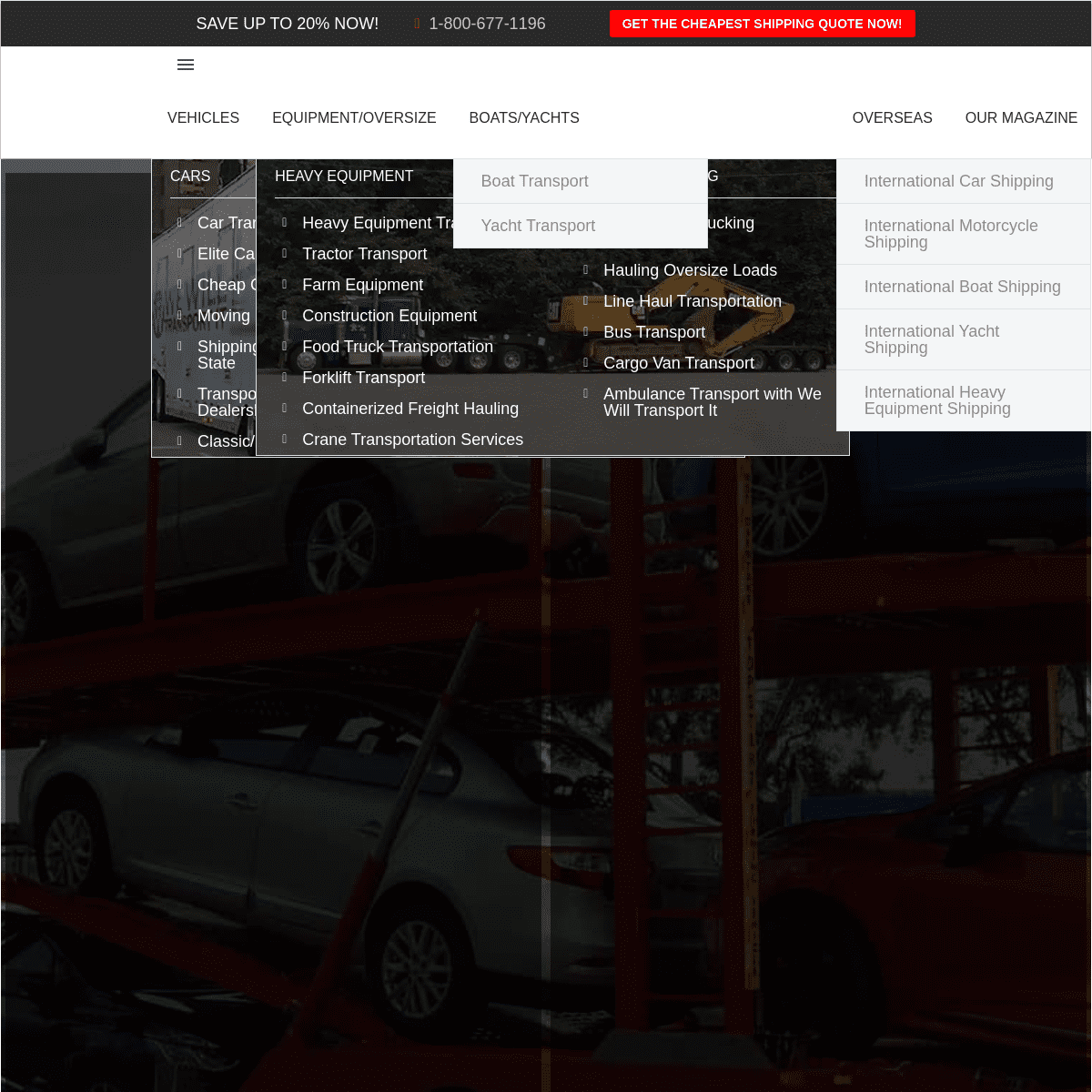
* Products
* Overview
* IVAAP™
* INTViewer™
* GeoToolkit™
* HTML5Viewer™
* Product Overview
* Demos
* Success Stories
* Solutions
* Overview
* Enterprise Data Visualization * For Exploration, Drilling, & Production* For Developers
* Services Overview
* Resources
* Blog
* Developer Community* All Resources
* About
* Overview
* News
* Events
* Careers
* Meet Our Team
* About INT
*
WE SIMPLIFY DATA VISUALIZATION FOR E&P INT empowers companies to build drilling and geoscience applications dedicated to business-critical data visualization.View Our Work For Enterprise VisualizationMore
For Exploration & ProductionMore
For Developers
More
WEBINAR: OPTIMIZING 3D SUBSURFACE WEB APPLICATIONS Moving Upstream into the cloud means more web applications with 3D capabilities, so developers have to learn how to tame the WebGL “beast.” The learning curve is steep and full of obstacles, so let INT help you take full advantage of 3D rendering and the trend of migrating applications to web browsers. Join INT developer experts in 3D to discuss how to OVERCOME THESE OBSTACLES and OPTIMIZE YOUR 3D SUBSURFACE WEB APPLICATIONS.Watch now
INT PRODUCTS
HTML5Viewer
Analysis and Data HTML5 Viewer ClientLearn More
IVAAP
The Enterprise Cloud Viewer for E&PLearn More
GeoToolkit
Data Visualization Developer Toolkit and LibrariesLearn More
INTViewer
Rapid Seismic QA/QC
Learn More
HTML5Viewer
Analysis and Data HTML5 Viewer ClientLearn More
IVAAP
The Enterprise Cloud Viewer for E&PLearn More
* 1
* 2
* 3
* 4
NEWS & EVENTS
Press
LATEST GEOTOOLKIT 2020.1 RELEASE INCLUDES NEW FEATURES IN 2D/3D VISUALIZATION, OPTIMIZED RENDERING IN WEB BROWSER, AND MORE.17 November 2020
This major release of GeoToolkit 2020.1 includes new 3D visualizationMORE
Press
INT ADDS CLIENT SDK AND IMPROVES SEISMIC AND SUBSURFACE VISUALIZATION PERFORMANCE WITH LATEST RELEASE OF IVAAP 2.69 September 2020
A new front-end SDK and improved seismic performance mean moreMORE
Press
INT RELEASES LATEST IVAAP VERSION SUPPORTING OSDU RELEASE 221 May 2020
INT is pleased to announce their contribution to The OpenMORE
CUSTOMER STORIES
FOOTER
SOLUTIONS
* Enterprise Data Visualization * Exploration, Drilling, & Production* For Developers
* Customer Success StoriesPRODUCTS
* IVAAP
* INTViewer
* GeoToolkit
* HTML5Viewer
* Interactive Demos
ABOUT
* News
* Events
* Careers
* Management Team
RESOURCES
* Blog
SUPPORT
* JIRA
* Developer CommunityCONTACT
� 1989–2020 Interactive Network Technologies, Inc.* __ __
* __ __
* __ __
Privacy Policy
COPYRIGHT © 2020 INTERACTIVE NETWORK TECHNOLOGIES, IncDetails
1