3
More Annotations


2


6
Favourite Annotations


2


4
Text
NATIONAL WEATHER SERVICERADARFORECAST MAPSCARIBOU, MEGRAND FORKS, NDDETROIT/PONTIAC, MIBUFFALO, NY NOAA National Weather Service National Weather Service. Click on the map above for detailed alerts or MARINE, TROPICAL AND TSUNAMI SERVICES BRANCHNOAA TELEPHONE RECORDINGSNWS SAN JUAN, PRNWS LAKE CHARLES, LA The National Weather Service (NWS) Marine Weather Services Program offers a broad range of marine forecast and warning products in graphical and text formats (See Tabs above). You can also get an hourly marine forecast for a single point here. Please provide us feedback here.. Clicking on the the map below will take you to the marine service pages of NWS Weather Forecast Offices (WFOs)
NWS RADAR
The NWS Radar site displays the radar on a map along with forecast and alerts. The radar products are also available as OGC compliant services to use in your application.. There are no additional pages onthis site.
RECREATIONAL FORECASTS The National Weather Service in Burlington produces the Lake Champlain recreational forecast from April through December, twice per day at approximately 4 am and 4 pm, with updates made when weather conditions become unrepresentative. Forecasts are valid for either 36 or 48 hours dependent on issuance time, and predict winds, significant waveLAKE TEMPERATURES
1031 AM EDT Sun May 30 2021 The water temperature off Rochester is 45 degrees. The daily lake temperatures for Lake Erie off Buffalo and for Lake Ontario off Rochester are included in the Nearshore Marine Forecast. Click the link for previous versions of the Nearshore MarineForecast. 1/3 of
GRAND FORKS, ND
NOAA National Weather Service Grand Forks, ND. June 7th and 8th Severe Event Review. Just after 4 pm on Monday afternoon (June 7th), several high based storms formed northwest of Cooperstown, North Dakota.BURLINGTON, VT
NOAA National Weather Service Burlington, VT. Important Rip Current Safety Information. Every year, over 100 people die from rip currentsin the US.
CARIBOU, ME
US Dept of Commerce National Oceanic and Atmospheric Administration National Weather Service Caribou, ME 810 Main Street Caribou, ME 04736GOODLAND, KS
Goodland, KS. News Headlines. Here's is the latest Tri-State climate report for last month and what to expect this month! May 26, 2021 Tornado and Large Hail Event. Get ready for summer weather hazards by visiting our Summer Safety website! May 24, 2021 Tornado Eventincluding the Selden, KS Tornado. Additional Headlines.BUFFALO, NY
US Dept of Commerce National Oceanic and Atmospheric Administration National Weather Service Buffalo, NY 587 Aero Drive Cheektowaga, NY14225 716-565-0204
NATIONAL WEATHER SERVICERADARFORECAST MAPSCARIBOU, MEGRAND FORKS, NDDETROIT/PONTIAC, MIBUFFALO, NY NOAA National Weather Service National Weather Service. Click on the map above for detailed alerts or MARINE, TROPICAL AND TSUNAMI SERVICES BRANCHNOAA TELEPHONE RECORDINGSNWS SAN JUAN, PRNWS LAKE CHARLES, LA The National Weather Service (NWS) Marine Weather Services Program offers a broad range of marine forecast and warning products in graphical and text formats (See Tabs above). You can also get an hourly marine forecast for a single point here. Please provide us feedback here.. Clicking on the the map below will take you to the marine service pages of NWS Weather Forecast Offices (WFOs)NWS RADAR
The NWS Radar site displays the radar on a map along with forecast and alerts. The radar products are also available as OGC compliant services to use in your application.. There are no additional pages onthis site.
RECREATIONAL FORECASTS The National Weather Service in Burlington produces the Lake Champlain recreational forecast from April through December, twice per day at approximately 4 am and 4 pm, with updates made when weather conditions become unrepresentative. Forecasts are valid for either 36 or 48 hours dependent on issuance time, and predict winds, significant waveLAKE TEMPERATURES
1031 AM EDT Sun May 30 2021 The water temperature off Rochester is 45 degrees. The daily lake temperatures for Lake Erie off Buffalo and for Lake Ontario off Rochester are included in the Nearshore Marine Forecast. Click the link for previous versions of the Nearshore MarineForecast. 1/3 of
GRAND FORKS, ND
NOAA National Weather Service Grand Forks, ND. June 7th and 8th Severe Event Review. Just after 4 pm on Monday afternoon (June 7th), several high based storms formed northwest of Cooperstown, North Dakota.BURLINGTON, VT
NOAA National Weather Service Burlington, VT. Important Rip Current Safety Information. Every year, over 100 people die from rip currentsin the US.
CARIBOU, ME
US Dept of Commerce National Oceanic and Atmospheric Administration National Weather Service Caribou, ME 810 Main Street Caribou, ME 04736GOODLAND, KS
Goodland, KS. News Headlines. Here's is the latest Tri-State climate report for last month and what to expect this month! May 26, 2021 Tornado and Large Hail Event. Get ready for summer weather hazards by visiting our Summer Safety website! May 24, 2021 Tornado Eventincluding the Selden, KS Tornado. Additional Headlines.BUFFALO, NY
US Dept of Commerce National Oceanic and Atmospheric Administration National Weather Service Buffalo, NY 587 Aero Drive Cheektowaga, NY14225 716-565-0204
NATIONAL FORECAST MAPS National Weather Maps. Surface Analysis. Highs, lows, fronts, troughs, outflow boundaries, squall lines, drylines for much of North America, the Western AtlanticNEXRAD VIEW
US Dept of Commerce National Oceanic and Atmospheric Administration National Weather Service National Level II NWS Radar Operation Center 1200 Westheimer DriveOBSERVED RAINFALL
6-hourly Estimated Rainfall. These preliminary observed rainfall graphics are automatically updated every 6 hours to show the latest 6-, 12-, 18-, and 24-hour rainfall totals for standard periods. Click individual images for larger version; click again or use arrow keys to step through the images. Since these data are preliminary and createdLAKE TEMPERATURES
1031 AM EDT Sun May 30 2021 The water temperature off Rochester is 45 degrees. The daily lake temperatures for Lake Erie off Buffalo and for Lake Ontario off Rochester are included in the Nearshore Marine Forecast. Click the link for previous versions of the Nearshore MarineForecast. 1/3 of
FORECAST.WEATHER.GOV forecast.weather.govBURLINGTON, VT
NOAA National Weather Service Burlington, VT. Important Rip Current Safety Information. Every year, over 100 people die from rip currentsin the US.
DODGE CITY, KS
Dodge City KS. A Few Clouds and Breezy. 67°F. 19°C Get Detailed info. Tonight. Breezy. Slight Chance T-storms then Areas Showers. Low:61°F. Monday.
GREAT LAKES FORECASTS BY ZONE Great Lakes Forecasts by Zone - Milwaukee, WI. Nearshore Marine Forecast which includes all these zones. Open Lake Forecast for Lake Michigan (All Zones - Includes Synopsis and MAFOR) (individual zones) Graphical Marine Forecasts are available here. Choose the map background and forecast element and zoom in to your area of interest.ABERDEEN, SD
US Dept of Commerce National Oceanic and Atmospheric Administration National Weather Service Aberdeen, SD 824 391st Ave S. Aberdeen, SD57401-9311
ALERTS.WEATHER.GOV
NOAA-NWS-ALERTS-IN1261A668A168.FloodAdvisory.1261A668A8D4IN.ILNFLSILN.dfcad264f47afb036201bf20e9650ac4 w-nws.webmaster@noaa.gov 2021-06-12T20:26:00-04:00 Actual Alert NATIONAL WEATHER SERVICERADARFORECAST MAPSCARIBOU, MEGRAND FORKS, NDDETROIT/PONTIAC, MIBUFFALO, NY NOAA National Weather Service National Weather Service. Click on the map above for detailed alerts or NWS RADARSOUTHEAST SECTOR LOOPUPPER MISS. VLYSRN. MISS. VLYNORTHEASTNATIONAL The NWS Radar site displays the radar on a map along with forecast and alerts. The radar products are also available as OGC compliant services to use in your application.. There are no additional pages onthis site.
MARINE, TROPICAL AND TSUNAMI SERVICES BRANCH The National Weather Service (NWS) Marine Weather Services Program offers a broad range of marine forecast and warning products in graphical and text formats (See Tabs above). You can also get an hourly marine forecast for a single point here. Please provide us feedback here.. Clicking on the the map below will take you to the marine service pages of NWS Weather Forecast Offices (WFOs)CARIBOU, ME
US Dept of Commerce National Oceanic and Atmospheric Administration National Weather Service Caribou, ME 810 Main Street Caribou, ME 04736GOODLAND, KS
Goodland, KS. News Headlines. Here's is the latest Tri-State climate report for last month and what to expect this month! May 26, 2021 Tornado and Large Hail Event. Get ready for summer weather hazards by visiting our Summer Safety website! May 24, 2021 Tornado Eventincluding the Selden, KS Tornado. Additional Headlines. NATIONAL WEATHER SERVICE MARINE FORECAST National Weather Service Marine Forecast. ANZ237-181500- Block Island Sound- 1027 PM EDT Mon May 17 2021 OVERNIGHT SW winds 5 to 10 kt. Seas around 2 ft. TUE W winds 5 to 10 kt, becoming SW 10 to 15 kt with gusts up to 20 kt in the afternoon. NWSCHAT - NOAA'S NATIONAL WEATHER SERVICE NWSChat is an Instant Messaging program utilized by NWS operational personnel to share critical warning decision expertise and other types of significant weather information essential to the NWS's mission of saving lives and property. This information is exchanged in real-time with the media and emergency response community, who in turn play aGLASGOW, MT
NOAA National Weather Service Glasgow, MT. Another round of severe thunderstorms are expected today. Large hail over 2”, damaging wind in excess of 70 mph, heavy rain and frequent lightning are possiblewith the storms.
GREAT LAKES FORECASTS BY ZONE Great Lakes Forecasts by Zone - Milwaukee, WI. Nearshore Marine Forecast which includes all these zones. Open Lake Forecast for Lake Michigan (All Zones - Includes Synopsis and MAFOR) (individual zones) Graphical Marine Forecasts are available here. Choose the map background and forecast element and zoom in to your area of interest.BUFFALO, NY
US Dept of Commerce National Oceanic and Atmospheric Administration National Weather Service Buffalo, NY 587 Aero Drive Cheektowaga, NY14225 716-565-0204
NATIONAL WEATHER SERVICERADARFORECAST MAPSCARIBOU, MEGRAND FORKS, NDDETROIT/PONTIAC, MIBUFFALO, NY NOAA National Weather Service National Weather Service. Click on the map above for detailed alerts or NWS RADARSOUTHEAST SECTOR LOOPUPPER MISS. VLYSRN. MISS. VLYNORTHEASTNATIONAL The NWS Radar site displays the radar on a map along with forecast and alerts. The radar products are also available as OGC compliant services to use in your application.. There are no additional pages onthis site.
MARINE, TROPICAL AND TSUNAMI SERVICES BRANCH The National Weather Service (NWS) Marine Weather Services Program offers a broad range of marine forecast and warning products in graphical and text formats (See Tabs above). You can also get an hourly marine forecast for a single point here. Please provide us feedback here.. Clicking on the the map below will take you to the marine service pages of NWS Weather Forecast Offices (WFOs)CARIBOU, ME
US Dept of Commerce National Oceanic and Atmospheric Administration National Weather Service Caribou, ME 810 Main Street Caribou, ME 04736GOODLAND, KS
Goodland, KS. News Headlines. Here's is the latest Tri-State climate report for last month and what to expect this month! May 26, 2021 Tornado and Large Hail Event. Get ready for summer weather hazards by visiting our Summer Safety website! May 24, 2021 Tornado Eventincluding the Selden, KS Tornado. Additional Headlines. NATIONAL WEATHER SERVICE MARINE FORECAST National Weather Service Marine Forecast. ANZ237-181500- Block Island Sound- 1027 PM EDT Mon May 17 2021 OVERNIGHT SW winds 5 to 10 kt. Seas around 2 ft. TUE W winds 5 to 10 kt, becoming SW 10 to 15 kt with gusts up to 20 kt in the afternoon. NWSCHAT - NOAA'S NATIONAL WEATHER SERVICE NWSChat is an Instant Messaging program utilized by NWS operational personnel to share critical warning decision expertise and other types of significant weather information essential to the NWS's mission of saving lives and property. This information is exchanged in real-time with the media and emergency response community, who in turn play aGLASGOW, MT
NOAA National Weather Service Glasgow, MT. Another round of severe thunderstorms are expected today. Large hail over 2”, damaging wind in excess of 70 mph, heavy rain and frequent lightning are possiblewith the storms.
GREAT LAKES FORECASTS BY ZONE Great Lakes Forecasts by Zone - Milwaukee, WI. Nearshore Marine Forecast which includes all these zones. Open Lake Forecast for Lake Michigan (All Zones - Includes Synopsis and MAFOR) (individual zones) Graphical Marine Forecasts are available here. Choose the map background and forecast element and zoom in to your area of interest.BUFFALO, NY
US Dept of Commerce National Oceanic and Atmospheric Administration National Weather Service Buffalo, NY 587 Aero Drive Cheektowaga, NY14225 716-565-0204
NATIONAL FORECAST MAPS National Weather Maps. Surface Analysis. Highs, lows, fronts, troughs, outflow boundaries, squall lines, drylines for much of North America, the Western Atlantic COUNTY COVERAGE BY STATE County Coverage Listings by State . NWR service to a county depends on reliable signal reception, which typically extends in about a 40 mile radius from the transmitter, assuming level terrain. Counties without NWR coverage or partial NWR coverage will be so indicated. Some counties or parts thereof, especially in mountainous areas, that are listed as having NWR coverage, may not have reliable FORECAST.WEATHER.GOV forecast.weather.govWEST GULF RFC
NOAA National Weather Service West Gulf RFC. WGRFC River Flood Summary: Minor: 28 (7%) Moderate: 6 (1%) Major: 0 (0%) Use the map below to view forecast locations experiencing flooding and link to detailed forecast information. NATIONAL WEATHER SERVICE MARINE FORECAST National Weather Service Marine Forecast. ANZ237-181500- Block Island Sound- 1027 PM EDT Mon May 17 2021 OVERNIGHT SW winds 5 to 10 kt. Seas around 2 ft. TUE W winds 5 to 10 kt, becoming SW 10 to 15 kt with gusts up to 20 kt in the afternoon.GLASGOW, MT
NOAA National Weather Service Glasgow, MT. Another round of severe thunderstorms are expected today. Large hail over 2”, damaging wind in excess of 70 mph, heavy rain and frequent lightning are possiblewith the storms.
PENDLETON, OR
NOAA National Weather Service Pendleton, OR. The National Weather Service Doppler Radar at the NWS Pendleton office (KPDT) will be down for maintenance for seven days beginning Thursday, June 10, 2021.SEATTLE/TACOMA, WA
A slow moving weather system will bring potential for scattered strong to severe storms with damaging wind and hail with areas of locally heavy rain in the South and Central Plains through Monday. A heat wave is expected to begin across the Northern Plains, Upper Midwest, and northern Great Basin with temperatures reaching over 20 degrees aboveALASKA REGION HQ
Welcome; Mission Statement; Are you looking for more specific weather or climate information? Click on any of the links for weather forecasts: Anchorage Forecast Office DULUTH, MN - WEATHER US Dept of Commerce National Oceanic and Atmospheric Administration National Weather Service Duluth, MN 5027 Miller Trunk Highway Duluth,MN 55811-1442
NATIONAL WEATHER SERVICERADARFORECAST MAPSCARIBOU, MEGRAND FORKS, NDDETROIT/PONTIAC, MIBUFFALO, NY NOAA National Weather Service National Weather Service. Click on the map above for detailed alerts or NATIONAL FORECAST MAPS National Weather Maps. Surface Analysis. Highs, lows, fronts, troughs, outflow boundaries, squall lines, drylines for much of North America, the Western Atlantic MARINE, TROPICAL AND TSUNAMI SERVICES BRANCH The National Weather Service (NWS) Marine Weather Services Program offers a broad range of marine forecast and warning products in graphical and text formats (See Tabs above). You can also get an hourly marine forecast for a single point here. Please provide us feedback here.. Clicking on the the map below will take you to the marine service pages of NWS Weather Forecast Offices (WFOs)NWS RADAR
The NWS Radar site displays the radar on a map along with forecast and alerts. The radar products are also available as OGC compliant services to use in your application.. There are no additional pages onthis site.
GRAND FORKS, ND
NOAA National Weather Service Grand Forks, ND. June 7th and 8th Severe Event Review. Just after 4 pm on Monday afternoon (June 7th), several high based storms formed northwest of Cooperstown, North Dakota. OCEAN PREDICTION CENTER Originates marine weather warnings, forecasts, and guidance in text and graphical format for maritime users in the northern waters of the Atlantic and Pacific. OPC continually monitors and analyzes maritime data, and provides guidance of marine atmospheric variables for purposes of protection of life and property, safety at sea, and enhancement of economic opportunity.CARIBOU, ME
US Dept of Commerce National Oceanic and Atmospheric Administration National Weather Service Caribou, ME 810 Main Street Caribou, ME 04736GOODLAND, KS
Goodland, KS. News Headlines. Here's is the latest Tri-State climate report for last month and what to expect this month! May 26, 2021 Tornado and Large Hail Event. Get ready for summer weather hazards by visiting our Summer Safety website! May 24, 2021 Tornado Eventincluding the Selden, KS Tornado. Additional Headlines.BUFFALO, NY
US Dept of Commerce National Oceanic and Atmospheric Administration National Weather Service Buffalo, NY 587 Aero Drive Cheektowaga, NY14225 716-565-0204
GREAT LAKES FORECASTS BY ZONE Great Lakes Forecasts by Zone - Milwaukee, WI. Nearshore Marine Forecast which includes all these zones. Open Lake Forecast for Lake Michigan (All Zones - Includes Synopsis and MAFOR) (individual zones) Graphical Marine Forecasts are available here. Choose the map background and forecast element and zoom in to your area of interest. NATIONAL WEATHER SERVICERADARFORECAST MAPSCARIBOU, MEGRAND FORKS, NDDETROIT/PONTIAC, MIBUFFALO, NY NOAA National Weather Service National Weather Service. Click on the map above for detailed alerts or NATIONAL FORECAST MAPS National Weather Maps. Surface Analysis. Highs, lows, fronts, troughs, outflow boundaries, squall lines, drylines for much of North America, the Western Atlantic MARINE, TROPICAL AND TSUNAMI SERVICES BRANCH The National Weather Service (NWS) Marine Weather Services Program offers a broad range of marine forecast and warning products in graphical and text formats (See Tabs above). You can also get an hourly marine forecast for a single point here. Please provide us feedback here.. Clicking on the the map below will take you to the marine service pages of NWS Weather Forecast Offices (WFOs)NWS RADAR
The NWS Radar site displays the radar on a map along with forecast and alerts. The radar products are also available as OGC compliant services to use in your application.. There are no additional pages onthis site.
GRAND FORKS, ND
NOAA National Weather Service Grand Forks, ND. June 7th and 8th Severe Event Review. Just after 4 pm on Monday afternoon (June 7th), several high based storms formed northwest of Cooperstown, North Dakota. OCEAN PREDICTION CENTER Originates marine weather warnings, forecasts, and guidance in text and graphical format for maritime users in the northern waters of the Atlantic and Pacific. OPC continually monitors and analyzes maritime data, and provides guidance of marine atmospheric variables for purposes of protection of life and property, safety at sea, and enhancement of economic opportunity.CARIBOU, ME
US Dept of Commerce National Oceanic and Atmospheric Administration National Weather Service Caribou, ME 810 Main Street Caribou, ME 04736GOODLAND, KS
Goodland, KS. News Headlines. Here's is the latest Tri-State climate report for last month and what to expect this month! May 26, 2021 Tornado and Large Hail Event. Get ready for summer weather hazards by visiting our Summer Safety website! May 24, 2021 Tornado Eventincluding the Selden, KS Tornado. Additional Headlines.BUFFALO, NY
US Dept of Commerce National Oceanic and Atmospheric Administration National Weather Service Buffalo, NY 587 Aero Drive Cheektowaga, NY14225 716-565-0204
GREAT LAKES FORECASTS BY ZONE Great Lakes Forecasts by Zone - Milwaukee, WI. Nearshore Marine Forecast which includes all these zones. Open Lake Forecast for Lake Michigan (All Zones - Includes Synopsis and MAFOR) (individual zones) Graphical Marine Forecasts are available here. Choose the map background and forecast element and zoom in to your area of interest. NATIONAL FORECAST MAPS National Weather Maps. Surface Analysis. Highs, lows, fronts, troughs, outflow boundaries, squall lines, drylines for much of North America, the Western Atlantic OCEAN PREDICTION CENTER Originates marine weather warnings, forecasts, and guidance in text and graphical format for maritime users in the northern waters of the Atlantic and Pacific. OPC continually monitors and analyzes maritime data, and provides guidance of marine atmospheric variables for purposes of protection of life and property, safety at sea, and enhancement of economic opportunity.GRAND FORKS, ND
NOAA National Weather Service Grand Forks, ND. June 7th and 8th Severe Event Review. Just after 4 pm on Monday afternoon (June 7th), several high based storms formed northwest of Cooperstown, North Dakota. COASTAL/GREAT LAKES FORECASTS BY ZONE Coastal and Great Lakes forecasts are subdivided by zone, each identified by text description and a Universal Generic Code (UGC). The entire text of these forecasts may be found at NWS Marine Text Forecasts and Products Listing which also serves as an alternate source of data. These forecasts areRAPID CITY, SD
NWS Forecast Office Rapid City, SD. Weather.gov > Rapid City, SD. Current Hazards. Storm and Precipitation Reports. Outlooks. Submit a Storm Report. Experimental Graphical Hazardous Weather Outlook. Current Conditions. Observations. ALASKA MARINE FORECASTS BY ZONE Alaska Marine Forecasts by Zone. Weather.gov > Marine, Tropical and Tsunami Services Branch > Alaska Marine Forecasts by Zone. Marine Text Forecasts. Coastal/Great Lakes Forecasts. Offshore Forecasts. High Seas Forecasts. Point Forecasts. Mobile Friendly Forecasts. Most Popular Marine Text Forecasts. EXIT - FORECAST.WEATHER.GOV Thank you for visiting a National Oceanic and Atmospheric Administration (NOAA) website. You have chosen to proceed to a non-government website for additional information.DODGE CITY, KS
Dodge City KS. A Few Clouds and Breezy. 67°F. 19°C Get Detailed info. Tonight. Breezy. Slight Chance T-storms then Areas Showers. Low:61°F. Monday.
PALAU - WEATHER
Satellite. Click here for satellite image loop _____ National Weather Service Palau Weather Service OfficeCENTRAL ILLINOIS
NWS Forecast Office Lincoln, IL. Scattered rain showers continue to affect areas mainly east of I-57 as of 6:15 PM. Showers near St. Louis area could affect areas up to I-72 later this evening. Additional rainfall amounts under 2 tenths of an inch are possible. NATIONAL WEATHER SERVICERADARFORECAST MAPSCARIBOU, MEGRAND FORKS, NDDETROIT/PONTIAC, MIBUFFALO, NY NOAA National Weather Service National Weather Service. Click on the map above for detailed alerts or NATIONAL FORECAST MAPS National Weather Maps. Surface Analysis. Highs, lows, fronts, troughs, outflow boundaries, squall lines, drylines for much of North America, the Western Atlantic MARINE, TROPICAL AND TSUNAMI SERVICES BRANCH The National Weather Service (NWS) Marine Weather Services Program offers a broad range of marine forecast and warning products in graphical and text formats (See Tabs above). You can also get an hourly marine forecast for a single point here. Please provide us feedback here.. Clicking on the the map below will take you to the marine service pages of NWS Weather Forecast Offices (WFOs)NWS RADAR
The NWS Radar site displays the radar on a map along with forecast and alerts. The radar products are also available as OGC compliant services to use in your application.. There are no additional pages onthis site.
GRAND FORKS, ND
NOAA National Weather Service Grand Forks, ND. June 7th and 8th Severe Event Review. Just after 4 pm on Monday afternoon (June 7th), several high based storms formed northwest of Cooperstown, North Dakota. OCEAN PREDICTION CENTER Originates marine weather warnings, forecasts, and guidance in text and graphical format for maritime users in the northern waters of the Atlantic and Pacific. OPC continually monitors and analyzes maritime data, and provides guidance of marine atmospheric variables for purposes of protection of life and property, safety at sea, and enhancement of economic opportunity.CARIBOU, ME
US Dept of Commerce National Oceanic and Atmospheric Administration National Weather Service Caribou, ME 810 Main Street Caribou, ME 04736GOODLAND, KS
Goodland, KS. News Headlines. Here's is the latest Tri-State climate report for last month and what to expect this month! May 26, 2021 Tornado and Large Hail Event. Get ready for summer weather hazards by visiting our Summer Safety website! May 24, 2021 Tornado Eventincluding the Selden, KS Tornado. Additional Headlines.BUFFALO, NY
US Dept of Commerce National Oceanic and Atmospheric Administration National Weather Service Buffalo, NY 587 Aero Drive Cheektowaga, NY14225 716-565-0204
GREAT LAKES FORECASTS BY ZONE Great Lakes Forecasts by Zone - Milwaukee, WI. Nearshore Marine Forecast which includes all these zones. Open Lake Forecast for Lake Michigan (All Zones - Includes Synopsis and MAFOR) (individual zones) Graphical Marine Forecasts are available here. Choose the map background and forecast element and zoom in to your area of interest. NATIONAL WEATHER SERVICERADARFORECAST MAPSCARIBOU, MEGRAND FORKS, NDDETROIT/PONTIAC, MIBUFFALO, NY NOAA National Weather Service National Weather Service. Click on the map above for detailed alerts or NATIONAL FORECAST MAPS National Weather Maps. Surface Analysis. Highs, lows, fronts, troughs, outflow boundaries, squall lines, drylines for much of North America, the Western Atlantic MARINE, TROPICAL AND TSUNAMI SERVICES BRANCH The National Weather Service (NWS) Marine Weather Services Program offers a broad range of marine forecast and warning products in graphical and text formats (See Tabs above). You can also get an hourly marine forecast for a single point here. Please provide us feedback here.. Clicking on the the map below will take you to the marine service pages of NWS Weather Forecast Offices (WFOs)NWS RADAR
The NWS Radar site displays the radar on a map along with forecast and alerts. The radar products are also available as OGC compliant services to use in your application.. There are no additional pages onthis site.
GRAND FORKS, ND
NOAA National Weather Service Grand Forks, ND. June 7th and 8th Severe Event Review. Just after 4 pm on Monday afternoon (June 7th), several high based storms formed northwest of Cooperstown, North Dakota. OCEAN PREDICTION CENTER Originates marine weather warnings, forecasts, and guidance in text and graphical format for maritime users in the northern waters of the Atlantic and Pacific. OPC continually monitors and analyzes maritime data, and provides guidance of marine atmospheric variables for purposes of protection of life and property, safety at sea, and enhancement of economic opportunity.CARIBOU, ME
US Dept of Commerce National Oceanic and Atmospheric Administration National Weather Service Caribou, ME 810 Main Street Caribou, ME 04736GOODLAND, KS
Goodland, KS. News Headlines. Here's is the latest Tri-State climate report for last month and what to expect this month! May 26, 2021 Tornado and Large Hail Event. Get ready for summer weather hazards by visiting our Summer Safety website! May 24, 2021 Tornado Eventincluding the Selden, KS Tornado. Additional Headlines.BUFFALO, NY
US Dept of Commerce National Oceanic and Atmospheric Administration National Weather Service Buffalo, NY 587 Aero Drive Cheektowaga, NY14225 716-565-0204
GREAT LAKES FORECASTS BY ZONE Great Lakes Forecasts by Zone - Milwaukee, WI. Nearshore Marine Forecast which includes all these zones. Open Lake Forecast for Lake Michigan (All Zones - Includes Synopsis and MAFOR) (individual zones) Graphical Marine Forecasts are available here. Choose the map background and forecast element and zoom in to your area of interest. NATIONAL FORECAST MAPS National Weather Maps. Surface Analysis. Highs, lows, fronts, troughs, outflow boundaries, squall lines, drylines for much of North America, the Western Atlantic OCEAN PREDICTION CENTER Originates marine weather warnings, forecasts, and guidance in text and graphical format for maritime users in the northern waters of the Atlantic and Pacific. OPC continually monitors and analyzes maritime data, and provides guidance of marine atmospheric variables for purposes of protection of life and property, safety at sea, and enhancement of economic opportunity.GRAND FORKS, ND
NOAA National Weather Service Grand Forks, ND. June 7th and 8th Severe Event Review. Just after 4 pm on Monday afternoon (June 7th), several high based storms formed northwest of Cooperstown, North Dakota. COASTAL/GREAT LAKES FORECASTS BY ZONE Coastal and Great Lakes forecasts are subdivided by zone, each identified by text description and a Universal Generic Code (UGC). The entire text of these forecasts may be found at NWS Marine Text Forecasts and Products Listing which also serves as an alternate source of data. These forecasts areRAPID CITY, SD
NWS Forecast Office Rapid City, SD. Weather.gov > Rapid City, SD. Current Hazards. Storm and Precipitation Reports. Outlooks. Submit a Storm Report. Experimental Graphical Hazardous Weather Outlook. Current Conditions. Observations. ALASKA MARINE FORECASTS BY ZONE Alaska Marine Forecasts by Zone. Weather.gov > Marine, Tropical and Tsunami Services Branch > Alaska Marine Forecasts by Zone. Marine Text Forecasts. Coastal/Great Lakes Forecasts. Offshore Forecasts. High Seas Forecasts. Point Forecasts. Mobile Friendly Forecasts. Most Popular Marine Text Forecasts. EXIT - FORECAST.WEATHER.GOV Thank you for visiting a National Oceanic and Atmospheric Administration (NOAA) website. You have chosen to proceed to a non-government website for additional information.DODGE CITY, KS
Dodge City KS. A Few Clouds and Breezy. 67°F. 19°C Get Detailed info. Tonight. Breezy. Slight Chance T-storms then Areas Showers. Low:61°F. Monday.
PALAU - WEATHER
Satellite. Click here for satellite image loop _____ National Weather Service Palau Weather Service OfficeCENTRAL ILLINOIS
NWS Forecast Office Lincoln, IL. Scattered rain showers continue to affect areas mainly east of I-57 as of 6:15 PM. Showers near St. Louis area could affect areas up to I-72 later this evening. Additional rainfall amounts under 2 tenths of an inch are possible. NATIONAL WEATHER SERVICERADARFORECAST MAPSCARIBOU, MEGRAND FORKS, NDDETROIT/PONTIAC, MIBUFFALO, NY NOAA National Weather Service National Weather Service. Click on the map above for detailed alerts or NWS RADARSOUTHEAST SECTOR LOOPUPPER MISS. VLYSRN. MISS. VLYNORTHEASTNATIONAL The NWS Radar site displays the radar on a map along with forecast and alerts. The radar products are also available as OGC compliant services to use in your application.. There are no additional pages onthis site.
MARINE, TROPICAL AND TSUNAMI SERVICES BRANCH The National Weather Service (NWS) Marine Weather Services Program offers a broad range of marine forecast and warning products in graphical and text formats (See Tabs above). You can also get an hourly marine forecast for a single point here. Please provide us feedback here.. Clicking on the the map below will take you to the marine service pages of NWS Weather Forecast Offices (WFOs) NATIONAL WEATHER SERVICE MARINE FORECAST PZZ132-070100- East Entrance U.S. Waters Strait Of Juan De Fuca- 855 AM PDT Sun Jun 6 2021 TODAY SE wind 5 to 15 kt becoming 10 to 20 kt in the afternoon. Wind waves 1 to 3 ft. A chance of showers in the morning then a chance of rain and a slight chance of tstms in theafternoon.
GOODLAND, KS
NOAA National Weather Service Goodland, KS. Here's is the latest Tri-State climate report for last month and what to expect this month!CARIBOU, ME
US Dept of Commerce National Oceanic and Atmospheric Administration National Weather Service Caribou, ME 810 Main Street Caribou, ME 04736 GREAT LAKES FORECASTS BY ZONE Nearshore Marine Zone Forecasts by the Milwaukee, WI Forecast Office - click on the area of interest. Nearshore Marine Forecast which includes all these zones. Special Marine Warning(s) and Marine Weather Statement(s) for these zones Marine Weather Message for these zones. Surf Zone Forecast. Open Lake Forecast for Lake Michigan (All Zones - Includes Synopsis and MAFOR) (individual zones)BUFFALO, NY
Get ready for Summer weather hazards by visiting our Summer Safety website! New 30 Year Climate Normals (1991-2020) Check out the latest issue of The Lake Breeze NewsletterSEATTLE/TACOMA, WA
US Dept of Commerce National Oceanic and Atmospheric Administration National Weather Service Seattle/Tacoma, WA 7600 Sand Point Way NE Seattle, WA 98115-6349ALASKA REGION HQ
Welcome; Mission Statement; Are you looking for more specific weather or climate information? Click on any of the links for weather forecasts: Anchorage Forecast Office NATIONAL WEATHER SERVICERADARFORECAST MAPSCARIBOU, MEGRAND FORKS, NDDETROIT/PONTIAC, MIBUFFALO, NY NOAA National Weather Service National Weather Service. Click on the map above for detailed alerts or NWS RADARSOUTHEAST SECTOR LOOPUPPER MISS. VLYSRN. MISS. VLYNORTHEASTNATIONAL The NWS Radar site displays the radar on a map along with forecast and alerts. The radar products are also available as OGC compliant services to use in your application.. There are no additional pages onthis site.
MARINE, TROPICAL AND TSUNAMI SERVICES BRANCH The National Weather Service (NWS) Marine Weather Services Program offers a broad range of marine forecast and warning products in graphical and text formats (See Tabs above). You can also get an hourly marine forecast for a single point here. Please provide us feedback here.. Clicking on the the map below will take you to the marine service pages of NWS Weather Forecast Offices (WFOs) NATIONAL WEATHER SERVICE MARINE FORECAST PZZ132-070100- East Entrance U.S. Waters Strait Of Juan De Fuca- 855 AM PDT Sun Jun 6 2021 TODAY SE wind 5 to 15 kt becoming 10 to 20 kt in the afternoon. Wind waves 1 to 3 ft. A chance of showers in the morning then a chance of rain and a slight chance of tstms in theafternoon.
GOODLAND, KS
NOAA National Weather Service Goodland, KS. Here's is the latest Tri-State climate report for last month and what to expect this month!CARIBOU, ME
US Dept of Commerce National Oceanic and Atmospheric Administration National Weather Service Caribou, ME 810 Main Street Caribou, ME 04736 GREAT LAKES FORECASTS BY ZONE Nearshore Marine Zone Forecasts by the Milwaukee, WI Forecast Office - click on the area of interest. Nearshore Marine Forecast which includes all these zones. Special Marine Warning(s) and Marine Weather Statement(s) for these zones Marine Weather Message for these zones. Surf Zone Forecast. Open Lake Forecast for Lake Michigan (All Zones - Includes Synopsis and MAFOR) (individual zones)BUFFALO, NY
Get ready for Summer weather hazards by visiting our Summer Safety website! New 30 Year Climate Normals (1991-2020) Check out the latest issue of The Lake Breeze NewsletterSEATTLE/TACOMA, WA
US Dept of Commerce National Oceanic and Atmospheric Administration National Weather Service Seattle/Tacoma, WA 7600 Sand Point Way NE Seattle, WA 98115-6349ALASKA REGION HQ
Welcome; Mission Statement; Are you looking for more specific weather or climate information? Click on any of the links for weather forecasts: Anchorage Forecast Office NATIONAL FORECAST MAPS National Weather Maps. Surface Analysis. Highs, lows, fronts, troughs, outflow boundaries, squall lines, drylines for much of North America, the Western Atlantic MARINE, TROPICAL AND TSUNAMI SERVICES BRANCH The National Weather Service (NWS) Marine Weather Services Program offers a broad range of marine forecast and warning products in graphical and text formats (See Tabs above). You can also get an hourly marine forecast for a single point here. Please provide us feedback here.. Clicking on the the map below will take you to the marine service pages of NWS Weather Forecast Offices (WFOs) NATIONAL WEATHER SERVICE NOAA National Weather Service National Weather Service. Click on the map above for detailed alerts or COUNTY COVERAGE BY STATE County Coverage Listings by State . NWR service to a county depends on reliable signal reception, which typically extends in about a 40 mile radius from the transmitter, assuming level terrain. Counties without NWR coverage or partial NWR coverage will be so indicated. Some counties or parts thereof, especially in mountainous areas, that are listed as having NWR coverage, may not have reliable NATIONAL WEATHER SERVICE MARINE FORECAST PZZ132-070100- East Entrance U.S. Waters Strait Of Juan De Fuca- 855 AM PDT Sun Jun 6 2021 TODAY SE wind 5 to 15 kt becoming 10 to 20 kt in the afternoon. Wind waves 1 to 3 ft. A chance of showers in the morning then a chance of rain and a slight chance of tstms in theafternoon.
WEST GULF RFC
1 day ago · NOAA National Weather Service West Gulf RFC. WGRFC River Flood Summary: Minor: 39 (9%) Moderate: 7 (1%) Major: 0 (0%) Use the map below to view forecast locations experiencing flooding and link to detailed forecast information.ALASKA REGION HQ
Welcome; Mission Statement; Are you looking for more specific weather or climate information? Click on any of the links for weather forecasts: Anchorage Forecast OfficeSEATTLE/TACOMA, WA
US Dept of Commerce National Oceanic and Atmospheric Administration National Weather Service Seattle/Tacoma, WA 7600 Sand Point Way NE Seattle, WA 98115-6349PENDLETON, OR
US Dept of Commerce National Oceanic and Atmospheric Administration National Weather Service Pendleton, OR 2001 NW 56th Drive Pendleton, OR 97801 (541) 276-7832 DULUTH, MN - WEATHER US Dept of Commerce National Oceanic and Atmospheric Administration National Weather Service Duluth, MN 5027 Miller Trunk Highway Duluth,MN 55811-1442
NATIONAL WEATHER SERVICERADARFORECAST MAPSCARIBOU, MEGRAND FORKS, NDDETROIT/PONTIAC, MIBUFFALO, NY NOAA National Weather Service National Weather Service. Click on the map above for detailed alerts or MARINE, TROPICAL AND TSUNAMI SERVICES BRANCHNOAA TELEPHONE RECORDINGSNWS SAN JUAN, PRNWS LAKE CHARLES, LA The National Weather Service (NWS) Marine Weather Services Program offers a broad range of marine forecast and warning products in graphical and text formats (See Tabs above). You can also get an hourly marine forecast for a single point here. Please provide us feedback here.. Clicking on the the map below will take you to the marine service pages of NWS Weather Forecast Offices (WFOs)NWS RADAR
The NWS Radar site displays the radar on a map along with forecast and alerts. The radar products are also available as OGC compliant services to use in your application.. There are no additional pages onthis site.
RECREATIONAL FORECASTS The National Weather Service in Burlington produces the Lake Champlain recreational forecast from April through December, twice per day at approximately 4 am and 4 pm, with updates made when weather conditions become unrepresentative. Forecasts are valid for either 36 or 48 hours dependent on issuance time, and predict winds, significant wave NATIONAL WEATHER SERVICE Point Forecast: 4 Miles W Lexington VA. 37.79°N 79.51°W (Elev. 1407 ft) Last Update: 6:01 am EDT May 11, 2021. Forecast Valid: 7am EDT May 11, 2021-6pm EDT May 17, 2021. Forecast Discussion. SOUTHERN REGION HEADQUARTERS NOAA National Weather Service Southern Region Headquarters. The Summer Heat Is On This Weekend. A large dome of high pressure will position itself from parts of the West through the entire Upper Midwest into the Northeast this weekend. OCEAN PREDICTION CENTER Originates marine weather warnings, forecasts, and guidance in text and graphical format for maritime users in the northern waters of the Atlantic and Pacific. OPC continually monitors and analyzes maritime data, and provides guidance of marine atmospheric variables for purposes of protection of life and property, safety at sea, and enhancement of economic opportunity.CARIBOU, ME
US Dept of Commerce National Oceanic and Atmospheric Administration National Weather Service Caribou, ME 810 Main Street Caribou, ME 04736SEATTLE/TACOMA, WA
A slow moving weather system will bring potential for scattered strong to severe storms with damaging wind and hail with areas of locally heavy rain in the South and Central Plains through Monday. A heat wave is expected to begin across the Northern Plains, Upper Midwest, and northern Great Basin with temperatures reaching over 20 degrees aboveBUFFALO, NY
NOAA National Weather Service Buffalo, NY. Get ready for Summer weather hazards by visiting our Summer Safety website! NATIONAL WEATHER SERVICERADARFORECAST MAPSCARIBOU, MEGRAND FORKS, NDDETROIT/PONTIAC, MIBUFFALO, NY NOAA National Weather Service National Weather Service. Click on the map above for detailed alerts or MARINE, TROPICAL AND TSUNAMI SERVICES BRANCHNOAA TELEPHONE RECORDINGSNWS SAN JUAN, PRNWS LAKE CHARLES, LA The National Weather Service (NWS) Marine Weather Services Program offers a broad range of marine forecast and warning products in graphical and text formats (See Tabs above). You can also get an hourly marine forecast for a single point here. Please provide us feedback here.. Clicking on the the map below will take you to the marine service pages of NWS Weather Forecast Offices (WFOs)NWS RADAR
The NWS Radar site displays the radar on a map along with forecast and alerts. The radar products are also available as OGC compliant services to use in your application.. There are no additional pages onthis site.
RECREATIONAL FORECASTS The National Weather Service in Burlington produces the Lake Champlain recreational forecast from April through December, twice per day at approximately 4 am and 4 pm, with updates made when weather conditions become unrepresentative. Forecasts are valid for either 36 or 48 hours dependent on issuance time, and predict winds, significant wave NATIONAL WEATHER SERVICE Point Forecast: 4 Miles W Lexington VA. 37.79°N 79.51°W (Elev. 1407 ft) Last Update: 6:01 am EDT May 11, 2021. Forecast Valid: 7am EDT May 11, 2021-6pm EDT May 17, 2021. Forecast Discussion. SOUTHERN REGION HEADQUARTERS NOAA National Weather Service Southern Region Headquarters. The Summer Heat Is On This Weekend. A large dome of high pressure will position itself from parts of the West through the entire Upper Midwest into the Northeast this weekend. OCEAN PREDICTION CENTER Originates marine weather warnings, forecasts, and guidance in text and graphical format for maritime users in the northern waters of the Atlantic and Pacific. OPC continually monitors and analyzes maritime data, and provides guidance of marine atmospheric variables for purposes of protection of life and property, safety at sea, and enhancement of economic opportunity.CARIBOU, ME
US Dept of Commerce National Oceanic and Atmospheric Administration National Weather Service Caribou, ME 810 Main Street Caribou, ME 04736SEATTLE/TACOMA, WA
A slow moving weather system will bring potential for scattered strong to severe storms with damaging wind and hail with areas of locally heavy rain in the South and Central Plains through Monday. A heat wave is expected to begin across the Northern Plains, Upper Midwest, and northern Great Basin with temperatures reaching over 20 degrees aboveBUFFALO, NY
NOAA National Weather Service Buffalo, NY. Get ready for Summer weather hazards by visiting our Summer Safety website! NATIONAL FORECAST MAPS National Weather Maps. Surface Analysis. Highs, lows, fronts, troughs, outflow boundaries, squall lines, drylines for much of North America, the Western AtlanticWEATHER.GOV
weather.gov
CITY STATE & ZIPCODE SEARCH PAGE NOAA's National Weather Service, City State & Zipcode Search Page RECREATIONAL FORECASTS The National Weather Service in Burlington produces the Lake Champlain recreational forecast from April through December, twice per day at approximately 4 am and 4 pm, with updates made when weather conditions become unrepresentative. Forecasts are valid for either 36 or 48 hours dependent on issuance time, and predict winds, significant wave SOUTHERN REGION HEADQUARTERS NOAA National Weather Service Southern Region Headquarters. The Summer Heat Is On This Weekend. A large dome of high pressure will position itself from parts of the West through the entire Upper Midwest into the Northeast this weekend. NATIONAL WEATHER SERVICE MARINE FORECAST PZZ132-060100- East Entrance U.S. Waters Strait Of Juan De Fuca- 853 AM PDT Sat Jun 5 2021 SMALL CRAFT ADVISORY IN EFFECT UNTIL 11 AM PDT THIS MORNING GALE WARNING IN EFFECT FROM 11 AM PDT THIS MORNING THROUGH THIS EVENING TODAY W wind 15 to 25 kt rising to 25 to 35 kt in the afternoon. Wind waves 2 to 4 ft building to 4 to 6 ft. A chance of showers in the morning then a slightDETROIT/PONTIAC, MI
Detroit/Pontiac, MI. News Headlines. Summer 2021 Outlook for Southeast Michigan. National Safe Boating Week is May 22-28, 2021 - Review Safety Tips Here Each Day. NOAA Lake Erie Harmful Algal Bloom Early Season Projection. Expert Forecast Opinion. GREAT LAKES FORECASTS BY ZONE Great Lakes Forecasts by Zone - Milwaukee, WI. Nearshore Marine Forecast which includes all these zones. Open Lake Forecast for Lake Michigan (All Zones - Includes Synopsis and MAFOR) (individual zones) Graphical Marine Forecasts are available here. Choose the map background and forecast element and zoom in to your area of interest.SEATTLE/TACOMA, WA
A slow moving weather system will bring potential for scattered strong to severe storms with damaging wind and hail with areas of locally heavy rain in the South and Central Plains through Monday. A heat wave is expected to begin across the Northern Plains, Upper Midwest, and northern Great Basin with temperatures reaching over 20 degrees aboveGREAT FALLS, MT
NWS Forecast Office Great Falls, MT. More Temperatures will continue to warm through Monday, when temperatures will soar into the 80s for almost everyone, with a few places possibly reaching 90. Unsettled weather will return to the area by the middle of next week, brining cooler temperatures and chances for rain and thunderstorms. NATIONAL WEATHER SERVICERADARFORECAST MAPSCARIBOU, MEGRAND FORKS, NDDETROIT/PONTIAC, MIBUFFALO, NY NOAA National Weather Service National Weather Service. Click on the map above for detailed alerts or MARINE, TROPICAL AND TSUNAMI SERVICES BRANCHNOAA TELEPHONE RECORDINGSNWS SAN JUAN, PRNWS LAKE CHARLES, LA The National Weather Service (NWS) Marine Weather Services Program offers a broad range of marine forecast and warning products in graphical and text formats (See Tabs above). You can also get an hourly marine forecast for a single point here. Please provide us feedback here.. Clicking on the the map below will take you to the marine service pages of NWS Weather Forecast Offices (WFOs)NWS RADAR
The NWS Radar site displays the radar on a map along with forecast and alerts. The radar products are also available as OGC compliant services to use in your application.. There are no additional pages onthis site.
RECREATIONAL FORECASTS The National Weather Service in Burlington produces the Lake Champlain recreational forecast from April through December, twice per day at approximately 4 am and 4 pm, with updates made when weather conditions become unrepresentative. Forecasts are valid for either 36 or 48 hours dependent on issuance time, and predict winds, significant wave NATIONAL WEATHER SERVICE Point Forecast: 4 Miles W Lexington VA. 37.79°N 79.51°W (Elev. 1407 ft) Last Update: 6:01 am EDT May 11, 2021. Forecast Valid: 7am EDT May 11, 2021-6pm EDT May 17, 2021. Forecast Discussion. SOUTHERN REGION HEADQUARTERS NOAA National Weather Service Southern Region Headquarters. The Summer Heat Is On This Weekend. A large dome of high pressure will position itself from parts of the West through the entire Upper Midwest into the Northeast this weekend. OCEAN PREDICTION CENTER Originates marine weather warnings, forecasts, and guidance in text and graphical format for maritime users in the northern waters of the Atlantic and Pacific. OPC continually monitors and analyzes maritime data, and provides guidance of marine atmospheric variables for purposes of protection of life and property, safety at sea, and enhancement of economic opportunity.CARIBOU, ME
US Dept of Commerce National Oceanic and Atmospheric Administration National Weather Service Caribou, ME 810 Main Street Caribou, ME 04736SEATTLE/TACOMA, WA
A slow moving weather system will bring potential for scattered strong to severe storms with damaging wind and hail with areas of locally heavy rain in the South and Central Plains through Monday. A heat wave is expected to begin across the Northern Plains, Upper Midwest, and northern Great Basin with temperatures reaching over 20 degrees aboveBUFFALO, NY
NOAA National Weather Service Buffalo, NY. Get ready for Summer weather hazards by visiting our Summer Safety website! NATIONAL WEATHER SERVICERADARFORECAST MAPSCARIBOU, MEGRAND FORKS, NDDETROIT/PONTIAC, MIBUFFALO, NY NOAA National Weather Service National Weather Service. Click on the map above for detailed alerts or MARINE, TROPICAL AND TSUNAMI SERVICES BRANCHNOAA TELEPHONE RECORDINGSNWS SAN JUAN, PRNWS LAKE CHARLES, LA The National Weather Service (NWS) Marine Weather Services Program offers a broad range of marine forecast and warning products in graphical and text formats (See Tabs above). You can also get an hourly marine forecast for a single point here. Please provide us feedback here.. Clicking on the the map below will take you to the marine service pages of NWS Weather Forecast Offices (WFOs)NWS RADAR
The NWS Radar site displays the radar on a map along with forecast and alerts. The radar products are also available as OGC compliant services to use in your application.. There are no additional pages onthis site.
RECREATIONAL FORECASTS The National Weather Service in Burlington produces the Lake Champlain recreational forecast from April through December, twice per day at approximately 4 am and 4 pm, with updates made when weather conditions become unrepresentative. Forecasts are valid for either 36 or 48 hours dependent on issuance time, and predict winds, significant wave NATIONAL WEATHER SERVICE Point Forecast: 4 Miles W Lexington VA. 37.79°N 79.51°W (Elev. 1407 ft) Last Update: 6:01 am EDT May 11, 2021. Forecast Valid: 7am EDT May 11, 2021-6pm EDT May 17, 2021. Forecast Discussion. SOUTHERN REGION HEADQUARTERS NOAA National Weather Service Southern Region Headquarters. The Summer Heat Is On This Weekend. A large dome of high pressure will position itself from parts of the West through the entire Upper Midwest into the Northeast this weekend. OCEAN PREDICTION CENTER Originates marine weather warnings, forecasts, and guidance in text and graphical format for maritime users in the northern waters of the Atlantic and Pacific. OPC continually monitors and analyzes maritime data, and provides guidance of marine atmospheric variables for purposes of protection of life and property, safety at sea, and enhancement of economic opportunity.CARIBOU, ME
US Dept of Commerce National Oceanic and Atmospheric Administration National Weather Service Caribou, ME 810 Main Street Caribou, ME 04736SEATTLE/TACOMA, WA
A slow moving weather system will bring potential for scattered strong to severe storms with damaging wind and hail with areas of locally heavy rain in the South and Central Plains through Monday. A heat wave is expected to begin across the Northern Plains, Upper Midwest, and northern Great Basin with temperatures reaching over 20 degrees aboveBUFFALO, NY
NOAA National Weather Service Buffalo, NY. Get ready for Summer weather hazards by visiting our Summer Safety website! NATIONAL FORECAST MAPS National Weather Maps. Surface Analysis. Highs, lows, fronts, troughs, outflow boundaries, squall lines, drylines for much of North America, the Western AtlanticWEATHER.GOV
weather.gov
CITY STATE & ZIPCODE SEARCH PAGE NOAA's National Weather Service, City State & Zipcode Search Page RECREATIONAL FORECASTS The National Weather Service in Burlington produces the Lake Champlain recreational forecast from April through December, twice per day at approximately 4 am and 4 pm, with updates made when weather conditions become unrepresentative. Forecasts are valid for either 36 or 48 hours dependent on issuance time, and predict winds, significant wave SOUTHERN REGION HEADQUARTERS NOAA National Weather Service Southern Region Headquarters. The Summer Heat Is On This Weekend. A large dome of high pressure will position itself from parts of the West through the entire Upper Midwest into the Northeast this weekend. NATIONAL WEATHER SERVICE MARINE FORECAST PZZ132-060100- East Entrance U.S. Waters Strait Of Juan De Fuca- 853 AM PDT Sat Jun 5 2021 SMALL CRAFT ADVISORY IN EFFECT UNTIL 11 AM PDT THIS MORNING GALE WARNING IN EFFECT FROM 11 AM PDT THIS MORNING THROUGH THIS EVENING TODAY W wind 15 to 25 kt rising to 25 to 35 kt in the afternoon. Wind waves 2 to 4 ft building to 4 to 6 ft. A chance of showers in the morning then a slightDETROIT/PONTIAC, MI
Detroit/Pontiac, MI. News Headlines. Summer 2021 Outlook for Southeast Michigan. National Safe Boating Week is May 22-28, 2021 - Review Safety Tips Here Each Day. NOAA Lake Erie Harmful Algal Bloom Early Season Projection. Expert Forecast Opinion. GREAT LAKES FORECASTS BY ZONE Great Lakes Forecasts by Zone - Milwaukee, WI. Nearshore Marine Forecast which includes all these zones. Open Lake Forecast for Lake Michigan (All Zones - Includes Synopsis and MAFOR) (individual zones) Graphical Marine Forecasts are available here. Choose the map background and forecast element and zoom in to your area of interest.SEATTLE/TACOMA, WA
A slow moving weather system will bring potential for scattered strong to severe storms with damaging wind and hail with areas of locally heavy rain in the South and Central Plains through Monday. A heat wave is expected to begin across the Northern Plains, Upper Midwest, and northern Great Basin with temperatures reaching over 20 degrees aboveGREAT FALLS, MT
NWS Forecast Office Great Falls, MT. More Temperatures will continue to warm through Monday, when temperatures will soar into the 80s for almost everyone, with a few places possibly reaching 90. Unsettled weather will return to the area by the middle of next week, brining cooler temperatures and chances for rain and thunderstorms.*
HOME
*
FORECAST
* Local
* Graphical
* Aviation
* Marine
* Rivers and Lakes
* Hurricanes
* Severe Weather
* Fire Weather
* Sun/Moon
* Long Range Forecasts * Climate Prediction* Space Weather
*
PAST WEATHER
* Past Weather
* Heating/Cooling Days * Monthly Temperatures* Records
* Astronomical Data
*
SAFETY
* Tsunamis
* Floods
* Beach Hazards
* Wildfire
* Cold
* Tornadoes
* Air Quality
* Fog
* Heat
* Hurricanes
* Lightning
* Safe Boating
* Rip Currents
* Thunderstorms
* Space Weather
* Sun (Ultraviolet Radiation)* Safety Campaigns
* Wind
* Drought
* Winter Weather
*
INFORMATION
* Owlie's Kids Page
* Wireless Emergency Alerts* Brochures
* Weather-Ready Nation * Cooperative Observers* Daily Briefing
* Damage/Fatality/Injury Statistics* Forecast Models
* GIS Data Portal
* NOAA Weather Radio* Publications
* SKYWARN Storm Spotters* StormReady
* TsunamiReady
* Service Change Notices*
EDUCATION
* Be A Force of Nature * NWS Education Home*
NEWS
* NWS News
* Events
* Social Media
* Pubs/Brochures/Booklets * NWS Media Contacts*
SEARCH
*
Search For
NWS All NOAA
*
ABOUT
* About NWS
* Organization
* Strategic Plan
* For NWS Employees
* International
* National Centers
* Careers
* Contact Us
* Glossary
Local forecast by
"City, St" or ZIP code Sorry, the location you searched for was not found. Please try anothersearch.
Multiple locations were found. Please select one of the following:Location Help
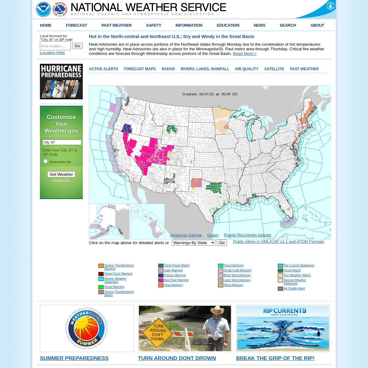
HOT IN THE NORTH-CENTRAL AND NORTHEAST U.S.; DRY AND WINDY IN THEGREAT BASIN
Heat Advisories are in place across portions of the Northeast states through Monday due to the combination of hot temperatures and high humidity. Heat Advisories are also in place for the Minneapolis/St. Paul metro area through Thursday. Critical fire weather conditions are forecast through Wednesday across portions of the Great Basin. ReadMore >
Customize Your WEATHER.GOV Enter Your City, ST or ZIP CodeRemember Me
Privacy Policy
LOADING...
*
ACTIVE ALERTS
*
FORECAST MAPS
*
RADAR
*
RIVERS, LAKES, RAINFALL*
AIR QUALITY
*
SATELLITE
*
PAST WEATHER
American Samoa Guam Puerto Rico/Virgin Islands Click on the map above for detailed alerts or Warnings By State Warnings By County AlaskaAlabamaArkansasArizonaCaliforniaColoradoConnecticutDistrict of ColumbiaDelawareFloridaGeorgiaHawaiiIowaIdahoIllinoisIndianaKansasKentuckyLouisianaMassachusettsMarylandMaineMichiganMinnesotaMissouriMarianasMississippiMontanaNorth CarolinaNorth DakotaNebraskaNew HampshireNew JerseyNew MexicoNevadaNew YorkOhioOklahomaOregonPennsylvaniaRhode IslandSouth CarolinaSouth DakotaTennesseeTexasMidwayUtahVirginiaVirgin IslandsVermontWashingtonWisconsinWest VirginiaWyoming Public Alerts in XML/CAP v1.1 and ATOM Formats Created: 06/07/21 at 05:01 UTC*
Severe Thunderstorm Warning*
Flash Flood Warning
*
Severe Weather Statement*
Flood Warning
*
Severe Thunderstorm Watch*
Flash Flood Watch
*
Gale Warning
*
Freeze Warning
*
Red Flag Warning
*
Heat Advisory
*
Flood Advisory
*
Small Craft Advisory*
Brisk Wind Advisory
*
Lake Wind Advisory
*
Wind Advisory
*
Rip Current Statement*
Flood Watch
*
Fire Weather Watch
*
Special Weather Statement*
Air Quality Alert
Summer Preparedness
Turn Around Dont Drown Break the grip of the rip! Follow us on Twitter Follow us on Facebook Follow us on YouTubeNWS RSS Feed
ACTIVE ALERTS
Warnings By State
Excessive Rainfall and Winter Weather ForecastsRiver Flooding
Latest Warnings
Thunderstorm/Tornado OutlookHurricanes
Fire Weather OutlooksUV Alerts
Drought
Space Weather
NOAA Weather Radio
NWS CAP Feeds
PAST WEATHER
Climate Monitoring
Past Weather
Monthly Temps
Records
Astronomical Data
Certified Weather DataCURRENT CONDITIONS
Radar
Climate Monitoring
River Levels
Observed PrecipitationSurface Weather
Upper Air
Marine and Buoy ReportsSnow Cover
Satellite
Space Weather
International ObservationsFORECAST
Local Forecast
International ForecastsSevere Weather
Current Outlook MapsDrought
Fire Weather
Fronts/Precipitation Maps Current Graphical Forecast MapsRivers
Marine
Offshore and High SeasHurricanes
Aviation Weather
Climatic Outlook
INFORMATION CENTER
Space Weather
Daily Briefing
Marine
Climate
Fire Weather
Aviation
Forecast Models
Water
GIS
Cooperative ObserversStorm Spotters
Tsunami Warning System National Water Center International WeatherWEATHER SAFETY
NOAA Weather Radio
StormReady
Heat
Lightning
Hurricanes
Thunderstorms
Tornadoes
Rip Currents
Floods
Tsunamis
TsunamiReady
Winter Weather
Ultra Violet RadiationAir Quality
Damage/Fatality/Injury StatisticsRed Cross
Federal Emergency Management Agency (FEMA)Brochures
Safe Boating
NEWS
Newsroom
Social Media
Events
Pubs/Brochures/BookletsEDUCATION
NWS Education Home
Be A Force of Nature NOAA Education ResourcesGlossary
JetStream
NWS Training Portal
NOAA Library
For Students, Parents and TeachersBrochures
ABOUT
Organization
Strategic Plan
For NWS Employees
International
National Centers
Products and ServicesCareers
Glossary
Contact Us
US Dept of Commerce
National Oceanic and Atmospheric Administration National Weather Service 1325 East West Highway Silver Spring, MD 20910 Comments? Questions? Please Contact Us.Disclaimer
Information Quality
Help
Glossary
Privacy Policy
Freedom of Information Act (FOIA)About Us
Career Opportunities Thank you for visiting a National Oceanic and Atmospheric Administration (NOAA) website. The link you have selected will take you to a non-U.S. Government website for additional information. NOAA is not responsible for the content of any linked website not operated by NOAA. This link is provided solely for your information and convenience, and does not imply any endorsement by NOAA or the U.S. Department of Commerce of the linked website or any information, products, or services contained therein. You will be redirected to: ContinueNew WindowCancelDetails
6