5
More Annotations


3


6
Favourite Annotations


1


5
Text
GEOINFORMATICS
Homepage | GeoInformatics | product and business news, reports, technical/application articles, hard- and software reviews, columnsand more.
EVENTS | GEOSPATIAL AND MORE | GEOINFORMATICS 20 -22 October 2021. Geospatial World Forum 2021. Taets Art & Event Park, Amsterdam, The Netherlands. website. 20 -22 October 2021. 24 - 25 November 2021. GEO Business. ExCel Londen, London, United Kingdom.website.
PFF AND TRIMBLE TO UTILIZE PROPRIETARY SMART FOLLOWING While many robots, including Spot, are currently controlled by joysticks operated in person or by telepresence from a remote location, operators can now leverage PFF’s exclusive smart following technology, that allows humans to lead other robots and machines, providing a larger range of navigation methods—remote control, autonomous, and now, following—in dynamic environments. THE POTENTIAL OF 3D POINT CLOUDS WITH AI Supper & Supper GmbH has developed a Software as a Service called Pointly, which allows to process 3D point clouds with the help of artificial intelligence (AI). The kick-off is scheduled with an AI-supported labelling tool for mid-2020. 3D point clouds are a key technology in the digital transformation of many industries, fromconstruction and
GLOBAL MAPPER V20 WITH 3D AND MAP LAYOUT IMPROVEMENTS Latest News. September 19, 2018. Global Mapper v20 is now available with 3D and Map Layout Improvements. With each release, Global Mapper further establishes its position as a major player in the GIS industry. Offering a comprehensive assortment of data visualization, processing, and analysis tools, Global Mapper is redefining the verynature
GENERATIVE DESIGN IN ARCHITECTURE AND CONSTRUCTION Generative Design in Architecture and Construction. Editors Desk. September 26, 2018. In the new era of generative design in architecture, engineering, and construction, designers and builders will use computers not just to describe buildings, but cocreate them. Before GPS, if you got lost while driving your car, you had to swallowyour pride
FREE PRECISIONMAPPER SOFTWARE FOR DRONE MAPPING May 10, 2017. PrecisionHawk, a commercial drone and data company, has opened access to its professional mapping and analytics software, PrecisionMapper, for free. By eliminating the cost barrier, operators have the flexibility to ‘bring their own drone’ and WHAT THE FUTURE OF LIDAR LOOKS LIKE The Future. To enable faster, safer transportation, LiDAR will continue to evolve and deliver higher resolutions capable of producing camera-like images with longer range, lower cost, in smaller form factors. The fusion of LiDAR and other environmental sensors, such as camera and radar, will happen at the pixel level to provide accurate3D
TRIMBLE LAUNCHES THE TRIMBLE T100 TABLET Trimble announced the Trimble T100, its latest high-performance tablet providing fast data processing for a variety of surveying, mapping, and GIS applications. The rugged tablet brings fast computing and a large screen to the field, supporting a full suite of applications for optical, GNSS, and laser scanning solutions, including the Trimble X7. FUGRO SITE INVESTIGATIONS FOR MOORSIDE NUCLEAR PROJECT Fugro site investigations for Moorside nuclear project. Editors Desk. September 26, 2016. NuGeneration Limited (NuGen) plans to build a nuclear power station of up to 3.8GW* gross capacity at Moorside, close to Sellafield, in West Cumbria. To facilitate the Moorside project, NuGen is undertaking a programme of works and studies toprovide
EVENTS | GEOSPATIAL AND MORE | GEOINFORMATICS 20 -22 October 2021. Geospatial World Forum 2021. Taets Art & Event Park, Amsterdam, The Netherlands. website. 20 -22 October 2021. 24 - 25 November 2021. GEO Business. ExCel Londen, London, United Kingdom.website.
LEICA CAPTIVATE
Leica Captivate offers a wide range of apps and it’s likely you’ve never heard of most of them. As you know, your Smartphone does not come with all available apps loaded – there are loads of additional apps which you can install as needed. It’s the same for Leica Captivate. Therefore, we are starting a series of articles, each of which is introducing a Leica Captivate app. TRIMBLE EXPANDS ITS GEOSPATIAL AUTOMATED MONITORING PORTFOLIO Trimble announced the addition of a geotechnical portfolio to its geospatial automated monitoring portfolio. | GeoInformatics INTRODUCING STANDALONE SOLUTIONS FOR MINE PLANNING Optimize your schedule, design blast patterns, and schedule activities with new standalone MineSight solutions from Hexagon Mining. MineSight is Hexagon Mining’s proven mine planning and mine modeling software. The latest standalone solutions deliver the same functionality as full MineSight products, but are packaged with a specialized viewer and toolset designed for integration with LEICA GEOSYSTEMS ANNOUNCES CITYMAPPER-2 September 17, 2019. Leica Geosystems, part of Hexagon, introduces the Leica CityMapper-2. This next generation hybrid oblique imaging and LiDAR sensor provides fast and efficient digitisation of cities. Leica CityMapper-2 hybrid airborne sensor increases productivity and data quality for creation of digital twins of cities and metropolitanareas.
HEXAGON INTRODUCES HXGN CONNECT HxGN Connect is a SaaS workspace for citywide collaboration enabling government agencies and other diverse organisations. GLOBAL PARTNERSHIP SCHNEIDER DIGITAL AND DAT/EM SYSTEMS for Surveying, Mapping & GIS 1SPATIAL STRENGTHENS STRATEGIC PARTNERSHIP WITH ORDNANCE Both organisations will combine their people, process and technology with a focus on identifying and delivering innovative solutions. TRIMBLE LAUNCHES THE TRIMBLE T100 TABLET Trimble announced the Trimble T100, its latest high-performance tablet providing fast data processing for a variety of surveying, mapping, and GIS applications. The rugged tablet brings fast computing and a large screen to the field, supporting a full suite of applications for optical, GNSS, and laser scanning solutions, including the Trimble X7. COMMERCIAL UAV EXPO AMERICAS ANNOUNCES 70+ EXHIBITORS FOR Organizers of Commercial UAV Expo Americas have announced an impressive list of more than 70 exhibitors. | GeoInformaticsGEOINFORMATICS
Homepage | GeoInformatics | product and business news, reports, technical/application articles, hard- and software reviews, columnsand more.
EVENTS | GEOSPATIAL AND MORE | GEOINFORMATICS 20 -22 October 2021. Geospatial World Forum 2021. Taets Art & Event Park, Amsterdam, The Netherlands. website. 20 -22 October 2021. 24 - 25 November 2021. GEO Business. ExCel Londen, London, United Kingdom.website.
PFF AND TRIMBLE TO UTILIZE PROPRIETARY SMART FOLLOWING While many robots, including Spot, are currently controlled by joysticks operated in person or by telepresence from a remote location, operators can now leverage PFF’s exclusive smart following technology, that allows humans to lead other robots and machines, providing a larger range of navigation methods—remote control, autonomous, and now, following—in dynamic environments. THE POTENTIAL OF 3D POINT CLOUDS WITH AI Supper & Supper GmbH has developed a Software as a Service called Pointly, which allows to process 3D point clouds with the help of artificial intelligence (AI). The kick-off is scheduled with an AI-supported labelling tool for mid-2020. 3D point clouds are a key technology in the digital transformation of many industries, fromconstruction and
GLOBAL MAPPER V20 WITH 3D AND MAP LAYOUT IMPROVEMENTS Latest News. September 19, 2018. Global Mapper v20 is now available with 3D and Map Layout Improvements. With each release, Global Mapper further establishes its position as a major player in the GIS industry. Offering a comprehensive assortment of data visualization, processing, and analysis tools, Global Mapper is redefining the verynature
GENERATIVE DESIGN IN ARCHITECTURE AND CONSTRUCTION Generative Design in Architecture and Construction. Editors Desk. September 26, 2018. In the new era of generative design in architecture, engineering, and construction, designers and builders will use computers not just to describe buildings, but cocreate them. Before GPS, if you got lost while driving your car, you had to swallowyour pride
FREE PRECISIONMAPPER SOFTWARE FOR DRONE MAPPING May 10, 2017. PrecisionHawk, a commercial drone and data company, has opened access to its professional mapping and analytics software, PrecisionMapper, for free. By eliminating the cost barrier, operators have the flexibility to ‘bring their own drone’ and WHAT THE FUTURE OF LIDAR LOOKS LIKE The Future. To enable faster, safer transportation, LiDAR will continue to evolve and deliver higher resolutions capable of producing camera-like images with longer range, lower cost, in smaller form factors. The fusion of LiDAR and other environmental sensors, such as camera and radar, will happen at the pixel level to provide accurate3D
TRIMBLE LAUNCHES THE TRIMBLE T100 TABLET Trimble announced the Trimble T100, its latest high-performance tablet providing fast data processing for a variety of surveying, mapping, and GIS applications. The rugged tablet brings fast computing and a large screen to the field, supporting a full suite of applications for optical, GNSS, and laser scanning solutions, including the Trimble X7. FUGRO SITE INVESTIGATIONS FOR MOORSIDE NUCLEAR PROJECT Fugro site investigations for Moorside nuclear project. Editors Desk. September 26, 2016. NuGeneration Limited (NuGen) plans to build a nuclear power station of up to 3.8GW* gross capacity at Moorside, close to Sellafield, in West Cumbria. To facilitate the Moorside project, NuGen is undertaking a programme of works and studies toprovide
GEOINFORMATICS
Homepage | GeoInformatics | product and business news, reports, technical/application articles, hard- and software reviews, columnsand more.
EVENTS | GEOSPATIAL AND MORE | GEOINFORMATICS 20 -22 October 2021. Geospatial World Forum 2021. Taets Art & Event Park, Amsterdam, The Netherlands. website. 20 -22 October 2021. 24 - 25 November 2021. GEO Business. ExCel Londen, London, United Kingdom.website.
PFF AND TRIMBLE TO UTILIZE PROPRIETARY SMART FOLLOWING While many robots, including Spot, are currently controlled by joysticks operated in person or by telepresence from a remote location, operators can now leverage PFF’s exclusive smart following technology, that allows humans to lead other robots and machines, providing a larger range of navigation methods—remote control, autonomous, and now, following—in dynamic environments. THE POTENTIAL OF 3D POINT CLOUDS WITH AI Supper & Supper GmbH has developed a Software as a Service called Pointly, which allows to process 3D point clouds with the help of artificial intelligence (AI). The kick-off is scheduled with an AI-supported labelling tool for mid-2020. 3D point clouds are a key technology in the digital transformation of many industries, fromconstruction and
GLOBAL MAPPER V20 WITH 3D AND MAP LAYOUT IMPROVEMENTS Latest News. September 19, 2018. Global Mapper v20 is now available with 3D and Map Layout Improvements. With each release, Global Mapper further establishes its position as a major player in the GIS industry. Offering a comprehensive assortment of data visualization, processing, and analysis tools, Global Mapper is redefining the verynature
GENERATIVE DESIGN IN ARCHITECTURE AND CONSTRUCTION Generative Design in Architecture and Construction. Editors Desk. September 26, 2018. In the new era of generative design in architecture, engineering, and construction, designers and builders will use computers not just to describe buildings, but cocreate them. Before GPS, if you got lost while driving your car, you had to swallowyour pride
FREE PRECISIONMAPPER SOFTWARE FOR DRONE MAPPING May 10, 2017. PrecisionHawk, a commercial drone and data company, has opened access to its professional mapping and analytics software, PrecisionMapper, for free. By eliminating the cost barrier, operators have the flexibility to ‘bring their own drone’ and WHAT THE FUTURE OF LIDAR LOOKS LIKE The Future. To enable faster, safer transportation, LiDAR will continue to evolve and deliver higher resolutions capable of producing camera-like images with longer range, lower cost, in smaller form factors. The fusion of LiDAR and other environmental sensors, such as camera and radar, will happen at the pixel level to provide accurate3D
TRIMBLE LAUNCHES THE TRIMBLE T100 TABLET Trimble announced the Trimble T100, its latest high-performance tablet providing fast data processing for a variety of surveying, mapping, and GIS applications. The rugged tablet brings fast computing and a large screen to the field, supporting a full suite of applications for optical, GNSS, and laser scanning solutions, including the Trimble X7. FUGRO SITE INVESTIGATIONS FOR MOORSIDE NUCLEAR PROJECT Fugro site investigations for Moorside nuclear project. Editors Desk. September 26, 2016. NuGeneration Limited (NuGen) plans to build a nuclear power station of up to 3.8GW* gross capacity at Moorside, close to Sellafield, in West Cumbria. To facilitate the Moorside project, NuGen is undertaking a programme of works and studies toprovide
EVENTS | GEOSPATIAL AND MORE | GEOINFORMATICS 20 -22 October 2021. Geospatial World Forum 2021. Taets Art & Event Park, Amsterdam, The Netherlands. website. 20 -22 October 2021. 24 - 25 November 2021. GEO Business. ExCel Londen, London, United Kingdom.website.
LEICA CAPTIVATE
Leica Captivate offers a wide range of apps and it’s likely you’ve never heard of most of them. As you know, your Smartphone does not come with all available apps loaded – there are loads of additional apps which you can install as needed. It’s the same for Leica Captivate. Therefore, we are starting a series of articles, each of which is introducing a Leica Captivate app. TRIMBLE EXPANDS ITS GEOSPATIAL AUTOMATED MONITORING PORTFOLIO Trimble announced the addition of a geotechnical portfolio to its geospatial automated monitoring portfolio. | GeoInformatics INTRODUCING STANDALONE SOLUTIONS FOR MINE PLANNING Optimize your schedule, design blast patterns, and schedule activities with new standalone MineSight solutions from Hexagon Mining. MineSight is Hexagon Mining’s proven mine planning and mine modeling software. The latest standalone solutions deliver the same functionality as full MineSight products, but are packaged with a specialized viewer and toolset designed for integration with LEICA GEOSYSTEMS ANNOUNCES CITYMAPPER-2 September 17, 2019. Leica Geosystems, part of Hexagon, introduces the Leica CityMapper-2. This next generation hybrid oblique imaging and LiDAR sensor provides fast and efficient digitisation of cities. Leica CityMapper-2 hybrid airborne sensor increases productivity and data quality for creation of digital twins of cities and metropolitanareas.
HEXAGON INTRODUCES HXGN CONNECT HxGN Connect is a SaaS workspace for citywide collaboration enabling government agencies and other diverse organisations. GLOBAL PARTNERSHIP SCHNEIDER DIGITAL AND DAT/EM SYSTEMS for Surveying, Mapping & GIS 1SPATIAL STRENGTHENS STRATEGIC PARTNERSHIP WITH ORDNANCE Both organisations will combine their people, process and technology with a focus on identifying and delivering innovative solutions. TRIMBLE LAUNCHES THE TRIMBLE T100 TABLET Trimble announced the Trimble T100, its latest high-performance tablet providing fast data processing for a variety of surveying, mapping, and GIS applications. The rugged tablet brings fast computing and a large screen to the field, supporting a full suite of applications for optical, GNSS, and laser scanning solutions, including the Trimble X7. COMMERCIAL UAV EXPO AMERICAS ANNOUNCES 70+ EXHIBITORS FOR Organizers of Commercial UAV Expo Americas have announced an impressive list of more than 70 exhibitors. | GeoInformaticsTHE PAST IS HERE
A Light, Interactive Web Viewer of Historical Maps, by Miguel Ángel Latre, Francisco J. Lopez-Pellicer, J. Nogueras-Iso, F. Javier Zarazaga-Soria. Introduction. We are result of our own history, and this can be clearly seen in the way human settlements in general (andcities in
THE POTENTIAL OF 3D POINT CLOUDS WITH AI Supper & Supper GmbH has developed a Software as a Service called Pointly, which allows to process 3D point clouds with the help of artificial intelligence (AI). The kick-off is scheduled with an AI-supported labelling tool for mid-2020. 3D point clouds are a key technology in the digital transformation of many industries, fromconstruction and
LEICA CAPTIVATE
Leica Captivate offers a wide range of apps and it’s likely you’ve never heard of most of them. As you know, your Smartphone does not come with all available apps loaded – there are loads of additional apps which you can install as needed. It’s the same for Leica Captivate. Therefore, we are starting a series of articles, each of which is introducing a Leica Captivate app. GENERATIVE DESIGN IN ARCHITECTURE AND CONSTRUCTIONGENERATIVE DESIGN APPLICATIONSGENERATIVE DESIGN BOOKGENERATIVE DESIGN COMPANIESGENERATIVE DESIGN REVITBEST GENERATIVE DESIGN SOFTWAREINVENTOR GENERATIVE DESIGN Generative Design in Architecture and Construction. Editors Desk. September 26, 2018. In the new era of generative design in architecture, engineering, and construction, designers and builders will use computers not just to describe buildings, but cocreate them. Before GPS, if you got lost while driving your car, you had to swallowyour pride
FREE PRECISIONMAPPER SOFTWARE FOR DRONE MAPPING May 10, 2017. PrecisionHawk, a commercial drone and data company, has opened access to its professional mapping and analytics software, PrecisionMapper, for free. By eliminating the cost barrier, operators have the flexibility to ‘bring their own drone’ and GLOBAL MAPPER V20 WITH 3D AND MAP LAYOUT IMPROVEMENTS Latest News. September 19, 2018. Global Mapper v20 is now available with 3D and Map Layout Improvements. With each release, Global Mapper further establishes its position as a major player in the GIS industry. Offering a comprehensive assortment of data visualization, processing, and analysis tools, Global Mapper is redefining the verynature
WHAT THE FUTURE OF LIDAR LOOKS LIKE The Future. To enable faster, safer transportation, LiDAR will continue to evolve and deliver higher resolutions capable of producing camera-like images with longer range, lower cost, in smaller form factors. The fusion of LiDAR and other environmental sensors, such as camera and radar, will happen at the pixel level to provide accurate3D
FIXED-WING UAV FOR LIDAR-BASED AERIAL SURVEY AND 3D MAPPINGLIDAR AERIAL SURVEYLIDAR SURVEY COSTAERIAL LIDAR SYSTEMSLIDAR ELEVATION ACCURACYLIDAR HORIZONTAL ACCURACYLIDAR RANGE ACCURACY The LiDAR sensor is specifically designed for UAV use, adding little weight or bulk to the Delair frame. The fully-integrated smart RGB camera enables real-time camera sensor control and in-flight photo review with automated quality checks. The new platform delivers increased accuracy in 3D mapping and modeling of terrain and corridorsin
ARCADIS USED DRONES TO 10X THEIR SURVEYING AND VOLUMETRIC Arcadis used drones to 10X their surveying and volumetric efficiency. When your client wants fast, accurate volumetric calculations for earthwork across a 46 kilometer highway, conventional surveying is not an option. Arcadis put Site Scan to the test on one of the largest highway projects in the Middle East – Qatar’s Orbital Highway. EUSI MAIN PROVIDER VHR SATELLITE IMAGERY TO EC EUSI main provider VHR satellite imagery to EC. Editors Desk. February 22, 2017. The Munich-based company European Space Imaging (EUSI) has been awarded another major supply contract for VHR satellite data and services to support checks within the EU Common Agricultural Policy (CAP). European Space Imaging announced that the company has signedTHE PAST IS HERE
A Light, Interactive Web Viewer of Historical Maps, by Miguel Ángel Latre, Francisco J. Lopez-Pellicer, J. Nogueras-Iso, F. Javier Zarazaga-Soria. Introduction. We are result of our own history, and this can be clearly seen in the way human settlements in general (andcities in
THE POTENTIAL OF 3D POINT CLOUDS WITH AI Supper & Supper GmbH has developed a Software as a Service called Pointly, which allows to process 3D point clouds with the help of artificial intelligence (AI). The kick-off is scheduled with an AI-supported labelling tool for mid-2020. 3D point clouds are a key technology in the digital transformation of many industries, fromconstruction and
LEICA CAPTIVATE
Leica Captivate offers a wide range of apps and it’s likely you’ve never heard of most of them. As you know, your Smartphone does not come with all available apps loaded – there are loads of additional apps which you can install as needed. It’s the same for Leica Captivate. Therefore, we are starting a series of articles, each of which is introducing a Leica Captivate app. GENERATIVE DESIGN IN ARCHITECTURE AND CONSTRUCTIONGENERATIVE DESIGN APPLICATIONSGENERATIVE DESIGN BOOKGENERATIVE DESIGN COMPANIESGENERATIVE DESIGN REVITBEST GENERATIVE DESIGN SOFTWAREINVENTOR GENERATIVE DESIGN Generative Design in Architecture and Construction. Editors Desk. September 26, 2018. In the new era of generative design in architecture, engineering, and construction, designers and builders will use computers not just to describe buildings, but cocreate them. Before GPS, if you got lost while driving your car, you had to swallowyour pride
FREE PRECISIONMAPPER SOFTWARE FOR DRONE MAPPING May 10, 2017. PrecisionHawk, a commercial drone and data company, has opened access to its professional mapping and analytics software, PrecisionMapper, for free. By eliminating the cost barrier, operators have the flexibility to ‘bring their own drone’ and GLOBAL MAPPER V20 WITH 3D AND MAP LAYOUT IMPROVEMENTS Latest News. September 19, 2018. Global Mapper v20 is now available with 3D and Map Layout Improvements. With each release, Global Mapper further establishes its position as a major player in the GIS industry. Offering a comprehensive assortment of data visualization, processing, and analysis tools, Global Mapper is redefining the verynature
WHAT THE FUTURE OF LIDAR LOOKS LIKE The Future. To enable faster, safer transportation, LiDAR will continue to evolve and deliver higher resolutions capable of producing camera-like images with longer range, lower cost, in smaller form factors. The fusion of LiDAR and other environmental sensors, such as camera and radar, will happen at the pixel level to provide accurate3D
FIXED-WING UAV FOR LIDAR-BASED AERIAL SURVEY AND 3D MAPPINGLIDAR AERIAL SURVEYLIDAR SURVEY COSTAERIAL LIDAR SYSTEMSLIDAR ELEVATION ACCURACYLIDAR HORIZONTAL ACCURACYLIDAR RANGE ACCURACY The LiDAR sensor is specifically designed for UAV use, adding little weight or bulk to the Delair frame. The fully-integrated smart RGB camera enables real-time camera sensor control and in-flight photo review with automated quality checks. The new platform delivers increased accuracy in 3D mapping and modeling of terrain and corridorsin
ARCADIS USED DRONES TO 10X THEIR SURVEYING AND VOLUMETRIC Arcadis used drones to 10X their surveying and volumetric efficiency. When your client wants fast, accurate volumetric calculations for earthwork across a 46 kilometer highway, conventional surveying is not an option. Arcadis put Site Scan to the test on one of the largest highway projects in the Middle East – Qatar’s Orbital Highway. EUSI MAIN PROVIDER VHR SATELLITE IMAGERY TO EC EUSI main provider VHR satellite imagery to EC. Editors Desk. February 22, 2017. The Munich-based company European Space Imaging (EUSI) has been awarded another major supply contract for VHR satellite data and services to support checks within the EU Common Agricultural Policy (CAP). European Space Imaging announced that the company has signed EVENTS | GEOSPATIAL AND MORE | GEOINFORMATICS 20 -22 October 2021. Geospatial World Forum 2021. Taets Art & Event Park, Amsterdam, The Netherlands. website. 20 -22 October 2021. 24 - 25 November 2021. GEO Business. ExCel Londen, London, United Kingdom.website.
THE PAST IS HERE
A Light, Interactive Web Viewer of Historical Maps, by Miguel Ángel Latre, Francisco J. Lopez-Pellicer, J. Nogueras-Iso, F. Javier Zarazaga-Soria. Introduction. We are result of our own history, and this can be clearly seen in the way human settlements in general (andcities in
TRIMBLE EXPANDS ITS GEOSPATIAL AUTOMATED MONITORING PORTFOLIO Trimble announced the addition of a geotechnical portfolio to its geospatial automated monitoring portfolio. | GeoInformaticsLEICA CAPTIVATE
Leica Captivate offers a wide range of apps and it’s likely you’ve never heard of most of them. As you know, your Smartphone does not come with all available apps loaded – there are loads of additional apps which you can install as needed. It’s the same for Leica Captivate. Therefore, we are starting a series of articles, each of which is introducing a Leica Captivate app. GLOBAL MAPPER LIDAR MODULE V18.1 Blue Marble Geographics announced the immediate availability of an update to the Global Mapper LiDAR Module. Released in conjunction with Global Mapper version 18.1, Blue Marble’s popular GIS software, the latest edition of the Module includes a powerful LiDAR QC function; a new option for visualizing and filtering a point cloud based on density; and a tool for assigning colors to LiDAR A GEO DATA MANAGEMENT SYSTEM FOR MALAWI January 31, 2018. In January 2018, GAF successfully established a Geological Data Management and Information system (GDMIS) for the Ministry of Natural Resources, Energy & Mining in Malawi. A modern and reliable management of geological and mining data is an essential asset to better understand existing natural resources, recognizemineral
ARCADIS USED DRONES TO 10X THEIR SURVEYING AND VOLUMETRIC Arcadis used drones to 10X their surveying and volumetric efficiency. When your client wants fast, accurate volumetric calculations for earthwork across a 46 kilometer highway, conventional surveying is not an option. Arcadis put Site Scan to the test on one of the largest highway projects in the Middle East – Qatar’s Orbital Highway. LA RÉUNION: BUILDING A ROAD IN THE INDIAN OCEAN The remote Indian Ocean island of La Réunion is a French overseas territory lying between Madagascar and Mauritius. Measuring 2,512km² in total with 866,506 residents, the island is densely populated with approximately a quarter of this population living in FUGRO SITE INVESTIGATIONS FOR MOORSIDE NUCLEAR PROJECT Fugro site investigations for Moorside nuclear project. Editors Desk. September 26, 2016. NuGeneration Limited (NuGen) plans to build a nuclear power station of up to 3.8GW* gross capacity at Moorside, close to Sellafield, in West Cumbria. To facilitate the Moorside project, NuGen is undertaking a programme of works and studies toprovide
DR. EDWARD M. MIKHAIL RECEIVES LIFETIME ACHIEVEMENT AWARD Mikhail has devoted 50 years of his professional life to supporting the Intelligence Community, both directly and indirectly. He joined Purdue University in 1965 and established what became a nationally and internationally leading graduate program in geomatics engineering. Although he is retired from the university, Mikhail continues to support the graduate program as a mentor to A WORLD OF OPEN DATA Nowadays, people are asking eagerly for Open Data and Open Government in order to gain access to unmediated facts and knowledge. Open data is, in fact, not a new idea. It is a way to share raw data with the public and put no limitations on its application. Open Government is a similar concept, encouraging A World of Open Data Read More » THE POTENTIAL OF 3D POINT CLOUDS WITH AI Supper & Supper GmbH has developed a Software as a Service called Pointly, which allows to process 3D point clouds with the help of artificial intelligence (AI). The kick-off is scheduled with an AI-supported labelling tool for mid-2020. 3D point clouds are a key technology in the digital transformation of many industries, fromconstruction and
INTEGRATING LASER SCANNING AND UAV DATA GIVES Integrating laser scanning and UAV data gives investigators a new 3D view. No one would dispute that courage is at the core of any police officer. It takes a certain braveness to dress for a job in which every day is a mystery –– people could go missing, be hurt, be fatally wounded –– and one’s own life could be at risk of injuryor
LEICA GEOSYSTEMS ANNOUNCES CITYMAPPER-2 September 17, 2019. Leica Geosystems, part of Hexagon, introduces the Leica CityMapper-2. This next generation hybrid oblique imaging and LiDAR sensor provides fast and efficient digitisation of cities. Leica CityMapper-2 hybrid airborne sensor increases productivity and data quality for creation of digital twins of cities and metropolitanareas.
LEICA CAPTIVATE
Leica Captivate offers a wide range of apps and it’s likely you’ve never heard of most of them. As you know, your Smartphone does not come with all available apps loaded – there are loads of additional apps which you can install as needed. It’s the same for Leica Captivate. Therefore, we are starting a series of articles, each of which is introducing a Leica Captivate app. FUGRO SITE INVESTIGATIONS FOR MOORSIDE NUCLEAR PROJECT Fugro site investigations for Moorside nuclear project. Editors Desk. September 26, 2016. NuGeneration Limited (NuGen) plans to build a nuclear power station of up to 3.8GW* gross capacity at Moorside, close to Sellafield, in West Cumbria. To facilitate the Moorside project, NuGen is undertaking a programme of works and studies toprovide
LA RÉUNION: BUILDING A ROAD IN THE INDIAN OCEANFRENCH ISLAND IN INDIAN OCEANABBEY ROAD 50 ANNIVERSARYABBEY ROAD 50TH ANNIVERSARYRÉUNION WIKIPEDIARÉUNION POINTS OF INTERESTREUNION ISLANDCOAST ROAD
The remote Indian Ocean island of La Réunion is a French overseas territory lying between Madagascar and Mauritius. Measuring 2,512km² in total with 866,506 residents, the island is densely populated with approximately a quarter of this population living in WHAT THE FUTURE OF LIDAR LOOKS LIKE The Future. To enable faster, safer transportation, LiDAR will continue to evolve and deliver higher resolutions capable of producing camera-like images with longer range, lower cost, in smaller form factors. The fusion of LiDAR and other environmental sensors, such as camera and radar, will happen at the pixel level to provide accurate3D
ARCADIS USED DRONES TO 10X THEIR SURVEYING AND VOLUMETRIC Arcadis used drones to 10X their surveying and volumetric efficiency. When your client wants fast, accurate volumetric calculations for earthwork across a 46 kilometer highway, conventional surveying is not an option. Arcadis put Site Scan to the test on one of the largest highway projects in the Middle East – Qatar’s Orbital Highway. ESRI AWARDS LOUDOUN COUNTY Esri has presented Loudoun County, Virginia with an award for 30 years of excellence in geographic information system (GIS) technology, during which time the county has continuously innovated how it delivers smarter, better government services. In 1962, when Washington Dulles International Airport opened in Loudoun, the county soontransformed
A WORLD OF OPEN DATA Nowadays, people are asking eagerly for Open Data and Open Government in order to gain access to unmediated facts and knowledge. Open data is, in fact, not a new idea. It is a way to share raw data with the public and put no limitations on its application. Open Government is a similar concept, encouraging A World of Open Data Read More » THE POTENTIAL OF 3D POINT CLOUDS WITH AI Supper & Supper GmbH has developed a Software as a Service called Pointly, which allows to process 3D point clouds with the help of artificial intelligence (AI). The kick-off is scheduled with an AI-supported labelling tool for mid-2020. 3D point clouds are a key technology in the digital transformation of many industries, fromconstruction and
INTEGRATING LASER SCANNING AND UAV DATA GIVES Integrating laser scanning and UAV data gives investigators a new 3D view. No one would dispute that courage is at the core of any police officer. It takes a certain braveness to dress for a job in which every day is a mystery –– people could go missing, be hurt, be fatally wounded –– and one’s own life could be at risk of injuryor
LEICA GEOSYSTEMS ANNOUNCES CITYMAPPER-2 September 17, 2019. Leica Geosystems, part of Hexagon, introduces the Leica CityMapper-2. This next generation hybrid oblique imaging and LiDAR sensor provides fast and efficient digitisation of cities. Leica CityMapper-2 hybrid airborne sensor increases productivity and data quality for creation of digital twins of cities and metropolitanareas.
LEICA CAPTIVATE
Leica Captivate offers a wide range of apps and it’s likely you’ve never heard of most of them. As you know, your Smartphone does not come with all available apps loaded – there are loads of additional apps which you can install as needed. It’s the same for Leica Captivate. Therefore, we are starting a series of articles, each of which is introducing a Leica Captivate app. FUGRO SITE INVESTIGATIONS FOR MOORSIDE NUCLEAR PROJECT Fugro site investigations for Moorside nuclear project. Editors Desk. September 26, 2016. NuGeneration Limited (NuGen) plans to build a nuclear power station of up to 3.8GW* gross capacity at Moorside, close to Sellafield, in West Cumbria. To facilitate the Moorside project, NuGen is undertaking a programme of works and studies toprovide
LA RÉUNION: BUILDING A ROAD IN THE INDIAN OCEANFRENCH ISLAND IN INDIAN OCEANABBEY ROAD 50 ANNIVERSARYABBEY ROAD 50TH ANNIVERSARYRÉUNION WIKIPEDIARÉUNION POINTS OF INTERESTREUNION ISLANDCOAST ROAD
The remote Indian Ocean island of La Réunion is a French overseas territory lying between Madagascar and Mauritius. Measuring 2,512km² in total with 866,506 residents, the island is densely populated with approximately a quarter of this population living in WHAT THE FUTURE OF LIDAR LOOKS LIKE The Future. To enable faster, safer transportation, LiDAR will continue to evolve and deliver higher resolutions capable of producing camera-like images with longer range, lower cost, in smaller form factors. The fusion of LiDAR and other environmental sensors, such as camera and radar, will happen at the pixel level to provide accurate3D
ARCADIS USED DRONES TO 10X THEIR SURVEYING AND VOLUMETRIC Arcadis used drones to 10X their surveying and volumetric efficiency. When your client wants fast, accurate volumetric calculations for earthwork across a 46 kilometer highway, conventional surveying is not an option. Arcadis put Site Scan to the test on one of the largest highway projects in the Middle East – Qatar’s Orbital Highway. ESRI AWARDS LOUDOUN COUNTY Esri has presented Loudoun County, Virginia with an award for 30 years of excellence in geographic information system (GIS) technology, during which time the county has continuously innovated how it delivers smarter, better government services. In 1962, when Washington Dulles International Airport opened in Loudoun, the county soontransformed
VIDEOS - GEOINFORMATICS Browse through the videos to learn and understand about trends in Surveying, Mapping, GIS, LiDAR, Remote Sensing and more. FREE NEWSLETTER SUBSCRIPTION Don’t miss our bi-weekly newsletter and stay up-to-date! Packed with news headlines, upcoming events, trends and insights, our bi-weekly eNewsletter is a ‘must have’ for readers.THE PAST IS HERE
A Light, Interactive Web Viewer of Historical Maps, by Miguel Ángel Latre, Francisco J. Lopez-Pellicer, J. Nogueras-Iso, F. Javier Zarazaga-Soria. Introduction. We are result of our own history, and this can be clearly seen in the way human settlements in general (andcities in
LEICA CAPTIVATE
Leica Captivate offers a wide range of apps and it’s likely you’ve never heard of most of them. As you know, your Smartphone does not come with all available apps loaded – there are loads of additional apps which you can install as needed. It’s the same for Leica Captivate. Therefore, we are starting a series of articles, each of which is introducing a Leica Captivate app. GENERATIVE DESIGN IN ARCHITECTURE AND CONSTRUCTION Generative Design in Architecture and Construction. Editors Desk. September 26, 2018. In the new era of generative design in architecture, engineering, and construction, designers and builders will use computers not just to describe buildings, but cocreate them. Before GPS, if you got lost while driving your car, you had to swallowyour pride
GEOSLAM LAUNCHES GEOSLAM CONNECT Connect is an automated processing platform that provides users with the flexibility to process their data to their exact specifications all through a series of interactive customisable script based workflows. Developed on GeoSLAM’s new operating system, LiDAR OS, and compatible with the ZEB family of products, the platform willminimise the
FUGRO SITE INVESTIGATIONS FOR MOORSIDE NUCLEAR PROJECT Fugro site investigations for Moorside nuclear project. Editors Desk. September 26, 2016. NuGeneration Limited (NuGen) plans to build a nuclear power station of up to 3.8GW* gross capacity at Moorside, close to Sellafield, in West Cumbria. To facilitate the Moorside project, NuGen is undertaking a programme of works and studies toprovide
TRIMBLE BUSINESS CENTER V5.3 RELEASED Trimble Business Center v5.3 released. This latest release features for CAD and drafting, surfaces, tunnels and corridors, mobile mapping and working with field data. The highlights are below. Use the new Command Line to run dozens of CAD commands by simply entering command aliases, keyboard shortcuts, and values (with occasional picking in ARCADIS USED DRONES TO 10X THEIR SURVEYING AND VOLUMETRIC Arcadis used drones to 10X their surveying and volumetric efficiency. When your client wants fast, accurate volumetric calculations for earthwork across a 46 kilometer highway, conventional surveying is not an option. Arcadis put Site Scan to the test on one of the largest highway projects in the Middle East – Qatar’s Orbital Highway. FREE PRECISIONMAPPER SOFTWARE FOR DRONE MAPPING May 10, 2017. PrecisionHawk, a commercial drone and data company, has opened access to its professional mapping and analytics software, PrecisionMapper, for free. By eliminating the cost barrier, operators have the flexibility to ‘bring their own drone’ andSkip to content
* Free Newsletter
* Advertising
* Contact
__ Menu
* Free Newsletter
* Advertising
* Contact
Facebook-f __ Twitter __* News__
* Latest News
* Editors Desk
* Newsletter
* Events
* Organizations
* Videos
__ Menu
* News__
* Latest News
* Editors Desk
* Newsletter
* Events
* Organizations
* Videos
__
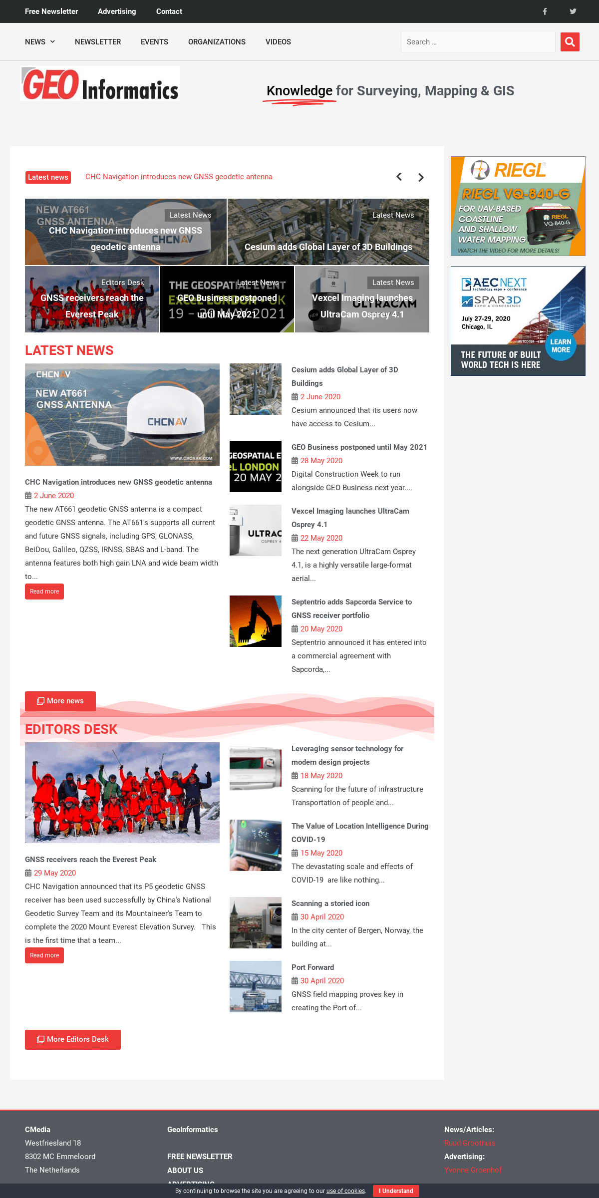
KNOWLEDGE FOR SURVEYING, MAPPING & GISHOMEPAGE
Latest news
","nextArrow":"","autoplay":true,"autoplaySpeed":5000}" dir="ltr"data-typing="1">_
Cesium adds Global Layer GEO Business postponed until May 2021 Vexcel Imaging launches UltraCam Osprey 4.1 Septentrio adds Sapcorda Service to GNSS receiver portfolio HERE and Loqate expand partnership__
","nextArrow":"","autoplay":false,"autoplaySpeed":5000,"rtl":false}"dir="ltr">
Latest News
CHC Navigation introduces new GNSS geodetic antennaLatest News
Cesium adds Global Layer of 3D BuildingsEditors Desk
GNSS receivers reach the Everest PeakLatest News
GEO Business postponed until May 2021Latest News
Vexcel Imaging launches UltraCam Osprey 4.1LATEST NEWS
CHC Navigation introduces new GNSS geodetic antenna_2 June 2020
The new AT661 geodetic GNSS antenna is a compact geodetic GNSS antenna. The AT661's supports all current and future GNSS signals, including GPS, GLONASS, BeiDou, Galileo, QZSS, IRNSS, SBAS and L-band. The antenna features both high gain LNA and wide beam width to...Read more
Cesium adds Global Layer of 3D Buildings__2 June 2020
Cesium announced that its users now have access to Cesium... GEO Business postponed until May 2021__28 May 2020
Digital Construction Week to run alongside GEO Business next year.... Vexcel Imaging launches UltraCam Osprey 4.1__22 May 2020
The next generation UltraCam Osprey 4.1, is a highly versatile large-format aerial... Septentrio adds Sapcorda Service to GNSS receiver portfolio__20 May 2020
Septentrio announced it has entered into a commercial agreement withSapcorda,...
__ More news
EDITORS DESK
GNSS receivers reach the Everest Peak__29 May 2020
CHC Navigation announced that its P5 geodetic GNSS receiver has been used successfully by China's National Geodetic Survey Team and its Mountaineer's Team to complete the 2020 Mount Everest Elevation Survey. This is the first time that a team...Read more
Leveraging sensor technology for modern design projects__18 May 2020
Scanning for the future of infrastructure Transportation of peopleand...
The Value of Location Intelligence During COVID-19__15 May 2020
The devastating scale and effects of COVID-19 are like nothing... Scanning a storied icon__30 April 2020
In the city center of Bergen, Norway, the building at...Port Forward
__30 April 2020
GNSS field mapping proves key in creating the Port of... __ More Editors DeskCMEDIA
Westfriesland 18
8302 MC Emmeloord
The Netherlands
+31 (0) 527 – 619 000 Facebook __ Twitter __GEOINFORMATICS
* FREE Newsletter
* About Us
* Advertising
* Contact
* Privacy & Cookies
__ Menu
* FREE Newsletter
* About Us
* Advertising
* Contact
* Privacy & Cookies
NEWS/ARTICLES:
Ruud Groothuis
ADVERTISING:
Yvonne Groenhof
CMedia is publisher of GeoInformatics and BIGnieuws Magazine By continuing to browse the site you are agreeing to our use of cookies . I Understand Scroll to TopDetails
4