2
More Annotations


4


5
Favourite Annotations


3


4
Text
WEATHER STORM WEATHER STORM CHASING WEATHER STORMS CHASERFLOODS IN LISMORE, NSWTROPICAL CYCLONESNORTHEAST NSW WEBCAM & AWS Weather storm weather storm chasing weather storms chaser stock photography storm Video Videos DVD DVDs movies movie footage storms Australian Severe Weather Photography over 35,000 photographs videos storm chasing storm chasers tornadoes hailstorms tropical cyclones observations latest satellite images weather maps bushfires bush wild
fires
TROPICAL CYCLONE TRACK MAPS FOR AUSTRALIA AND THE SOUTHERN Current, Recent and Historical Tropical Cyclones. Tropical cyclones, hurricanes and typhoons for Australia and the Southern Hemisphere developed by Michael Bath. This site is not updated with real time information - be sure to always check the Bureau of Meteorology and Joint Typhoon Warning Center for the very latest warnings. May 2021: BUSH FIRES / WILD FIRES 1957 - Bush fires in the Blue Mountains area driven by gale force winds destroyed 25 homes, shops, schools, churches and a hospital.. 1962 - around 7 fires in the Warrandyte, Montrose, Olinda and Mooralbark areas. Many houses were lost including at Warranwood. 1964/65 - Major fires occurred in the Snowy Mountains, Southern Tablelands and outer metropolitan area. OBSERVING FOG, MIST, FROST AND DEW Observing fog, mist, frost and dew. Fog can be described as a cloud forming very close to or at ground level. It requires air with sufficient moisture to cool or to be cooled to a temperature to achieve condensation. Once condensation occurs, visibility decreases dramatically. It therefore becomes very WEATHER RADAR IMAGES ARCHIVED RADAR LOOPS AUSTRALIAN Registered Users Australian Weather Watch Radar - 128km, 256km and 512km radius single images and 60 minute loops updated every 6 or 10 minutes for Australia radar sites. 64km radius and Doppler wind images are also available for a few newer radar sites. Access to these images require a subscription from the BoM. BoM Radar Archive by Oscilmet OBSERVING CLOUDS DURING SUNSET AND SUNRISE Observing clouds during sunset and sunrise. During sunrise and sunset, a good opportunity arises to observe different aspects of clouds. During these periods, changes in the contrast and colour are observed as well as structure of the clouds. Such sunrises and sunsets can develop into some of the most spectacular events that exist inmeteorology.
SUPERCELL STORMS THUNDERSTORMS OBSERVATION TECHNQIUES Observing Thunderstorms: Identification Features; Observing typical cloud types associated with thunderstorms as they approach; Observing features of thunderstorms AUSTRALIAN REGION TROPICAL CYCLONE SEASON 1955 Australian Region Tropical Cyclone Season 1955 - 1956 Southern Hemisphere Tropical Cyclones Hurricanes Typhoons Bureau of MeteorologyBoM Data
JULY 2002 TO JUNE 2003 TROPICAL CYCLONES IN THE SOUTH BoM data obtained from the Bureau of Meteorology, Melbourne JTWC data obtained from the Naval Pacific Meteorology and Oceanography / Joint Typhoon Warning Centre, Hawaii . Historical Season Maps for all seasons that data is available. Plotting Information about the track maps on this website. Also includes southern hemisphere TC regions and BoM TC intensity classification scale. KNOWN TROPICAL CYCLONE IMPACTS IN THE GULF OF … Jeff Callaghan, Bureau of Meteorology, Brisbane. 3 Mawson Cyclone Mar 1923 +8.9(+7.3) miles on 30th and 31st. At Burketown at storm surge of 9 feet was reported and at Pt McArthur a storm surge of between 18 feet and 8 feet was reported. WEATHER STORM WEATHER STORM CHASING WEATHER STORMS CHASERFLOODS IN LISMORE, NSWTROPICAL CYCLONESNORTHEAST NSW WEBCAM & AWS Weather storm weather storm chasing weather storms chaser stock photography storm Video Videos DVD DVDs movies movie footage storms Australian Severe Weather Photography over 35,000 photographs videos storm chasing storm chasers tornadoes hailstorms tropical cyclones observations latest satellite images weather maps bushfires bush wildfires
TROPICAL CYCLONE TRACK MAPS FOR AUSTRALIA AND THE SOUTHERN Current, Recent and Historical Tropical Cyclones. Tropical cyclones, hurricanes and typhoons for Australia and the Southern Hemisphere developed by Michael Bath. This site is not updated with real time information - be sure to always check the Bureau of Meteorology and Joint Typhoon Warning Center for the very latest warnings. May 2021: BUSH FIRES / WILD FIRES 1957 - Bush fires in the Blue Mountains area driven by gale force winds destroyed 25 homes, shops, schools, churches and a hospital.. 1962 - around 7 fires in the Warrandyte, Montrose, Olinda and Mooralbark areas. Many houses were lost including at Warranwood. 1964/65 - Major fires occurred in the Snowy Mountains, Southern Tablelands and outer metropolitan area. OBSERVING FOG, MIST, FROST AND DEW Observing fog, mist, frost and dew. Fog can be described as a cloud forming very close to or at ground level. It requires air with sufficient moisture to cool or to be cooled to a temperature to achieve condensation. Once condensation occurs, visibility decreases dramatically. It therefore becomes very WEATHER RADAR IMAGES ARCHIVED RADAR LOOPS AUSTRALIAN Registered Users Australian Weather Watch Radar - 128km, 256km and 512km radius single images and 60 minute loops updated every 6 or 10 minutes for Australia radar sites. 64km radius and Doppler wind images are also available for a few newer radar sites. Access to these images require a subscription from the BoM. BoM Radar Archive by Oscilmet OBSERVING CLOUDS DURING SUNSET AND SUNRISE Observing clouds during sunset and sunrise. During sunrise and sunset, a good opportunity arises to observe different aspects of clouds. During these periods, changes in the contrast and colour are observed as well as structure of the clouds. Such sunrises and sunsets can develop into some of the most spectacular events that exist inmeteorology.
SUPERCELL STORMS THUNDERSTORMS OBSERVATION TECHNQIUES Observing Thunderstorms: Identification Features; Observing typical cloud types associated with thunderstorms as they approach; Observing features of thunderstorms AUSTRALIAN REGION TROPICAL CYCLONE SEASON 1955 Australian Region Tropical Cyclone Season 1955 - 1956 Southern Hemisphere Tropical Cyclones Hurricanes Typhoons Bureau of MeteorologyBoM Data
JULY 2002 TO JUNE 2003 TROPICAL CYCLONES IN THE SOUTH BoM data obtained from the Bureau of Meteorology, Melbourne JTWC data obtained from the Naval Pacific Meteorology and Oceanography / Joint Typhoon Warning Centre, Hawaii . Historical Season Maps for all seasons that data is available. Plotting Information about the track maps on this website. Also includes southern hemisphere TC regions and BoM TC intensity classification scale. KNOWN TROPICAL CYCLONE IMPACTS IN THE GULF OF … Jeff Callaghan, Bureau of Meteorology, Brisbane. 3 Mawson Cyclone Mar 1923 +8.9(+7.3) miles on 30th and 31st. At Burketown at storm surge of 9 feet was reported and at Pt McArthur a storm surge of between 18 feet and 8 feet was reported. TROPICAL CYCLONE TRACK MAPS FOR AUSTRALIA AND THE SOUTHERN Current, Recent and Historical Tropical Cyclones. Tropical cyclones, hurricanes and typhoons for Australia and the Southern Hemisphere developed by Michael Bath. This site is not updated with real time information - be sure to always check the Bureau of Meteorology and Joint Typhoon Warning Center for the very latest warnings. May 2021: BUSH FIRES WILD FIRES AUSTRALIAN BUSHFIRES WILDFIRES Introduction: Australia is known to have some of the worst Bush Fires / Wild Fires prone country in the world! Due to our extreme weather conditions it is not uncommon for us to have Wild Fires every fire season which are started by a wide variety of causes. TROPICAL CYCLONE PLOTTING INFORMATION / INTENSITY SCALE Bureau of Meteorology (BoM) Data. Cyclones are generally only included if the track commenced or moved into the Australian tropical cyclone warning areas (between 90 and 160 degrees East).. Listing of all BoM tropical cyclones: this includes all tropical cyclones tracked by the BoM since the 1906/07 season.Historical data is reviewed once updated best track data becomes available. STOCK FOOTAGE STORM DVD TORNADO VIDEO DVD DVDS VIDEOS EYE Top of page. Purchasing stock video of Australian or US footage? For the purchase of Videos and more information of latest releases, contracted storm video footage or DVD's, contact us 0408 020 468 (Aust) or +61 408 020 468 (Int.) or e-mail Jimmy Deguara for further payment options, information or special distribution rights. Some samples are available in the Australian footage section and US WEATHER MAPS WEATHER MODEL OUTPUT ATMOSPHERIC SOUNDINGS Weather Maps Weather Model Output Atmospheric Soundings Diagrams Weather Charts Australian Severe Weather Data and Links - links to weather charts, weather forecasts, satellite images, storm chaser home pages, weather home pages, Australian weather home pages, US homepages, AVNPlotter
JULY 2002 TO JUNE 2003 TROPICAL CYCLONES IN THE SOUTH BoM data obtained from the Bureau of Meteorology, Melbourne JTWC data obtained from the Naval Pacific Meteorology and Oceanography / Joint Typhoon Warning Centre, Hawaii . Historical Season Maps for all seasons that data is available. Plotting Information about the track maps on this website. Also includes southern hemisphere TC regions and BoM TC intensity classification scale. AUSTRALIAN REGION TROPICAL CYCLONE SEASON 1999 Australian Region Tropical Cyclone Season 1999 - 2000 Southern Hemisphere Tropical Cyclones Hurricanes Typhoons Bureau of MeteorologyBoM Data
TROPICAL CYCLONE IMPACTS ALONG THE AUSTRALIAN EAST … 16 Mar 1875 Gales and heavy rain at Maryborough. Verandahs were blown down. A vessel at sea reported:- SE gale off Wide Bay bar on the 16th. !7th E and stronger gale with huge seas washing boat off MONTHLY GLOBAL TROPICAL CYCLONE SUMMARY MARCH 1999 MONTHLY GLOBAL TROPICAL CYCLONE SUMMARY MARCH, 1999 (For general comments about the nature of these summaries, as well as information on how to download the tabular cyclone track files, see the Author's Note at the end of this summary.) NSW NORTHERN TABLELANDS SNOW CHASE FORECASTING GUIDE Case Studies. 2008. Autumn 2008 has already seen two major cold outbreaks across Southeast Australia. The first occurred during 26-28 April but this event did not bring enough moisture to the NorthernRanges.
WEATHER STORM WEATHER STORM CHASING WEATHER STORMS CHASERFLOODS IN LISMORE, NSWTROPICAL CYCLONESNORTHEAST NSW WEBCAM & AWS Weather storm weather storm chasing weather storms chaser stock photography storm Video Videos DVD DVDs movies movie footage storms Australian Severe Weather Photography over 35,000 photographs videos storm chasing storm chasers tornadoes hailstorms tropical cyclones observations latest satellite images weather maps bushfires bush wildfires
BUSH FIRES WILD FIRES AUSTRALIAN BUSHFIRES WILDFIRESEMAIL CONTACTSSEVERE WEATHER FORUMPYROCUMULUSAUSTRALIAN BUSHFIRE HISTORY Introduction: Australia is known to have some of the worst Bush Fires / Wild Fires prone country in the world! Due to our extreme weather conditions it is not uncommon for us to have Wild Fires every fire season which are started by a wide variety of causes. BUSH FIRES / WILD FIRES 1957 - Bush fires in the Blue Mountains area driven by gale force winds destroyed 25 homes, shops, schools, churches and a hospital.. 1962 - around 7 fires in the Warrandyte, Montrose, Olinda and Mooralbark areas. Many houses were lost including at Warranwood. 1964/65 - Major fires occurred in the Snowy Mountains, Southern Tablelands and outer metropolitan area. WEATHER RADAR IMAGES ARCHIVED RADAR LOOPS AUSTRALIAN Registered Users Australian Weather Watch Radar - 128km, 256km and 512km radius single images and 60 minute loops updated every 6 or 10 minutes for Australia radar sites. 64km radius and Doppler wind images are also available for a few newer radar sites. Access to these images require a subscription from the BoM. BoM Radar Archive by Oscilmet WEATHER MAPS WEATHER MODEL OUTPUT ATMOSPHERIC SOUNDINGS Weather Maps Weather Model Output Atmospheric Soundings Diagrams Weather Charts Australian Severe Weather Data and Links - links to weather charts, weather forecasts, satellite images, storm chaser home pages, weather home pages, Australian weather home pages, US homepages, AVNPlotter
OBSERVING CLOUDS DURING SUNSET AND SUNRISE Observing clouds during sunset and sunrise. During sunrise and sunset, a good opportunity arises to observe different aspects of clouds. During these periods, changes in the contrast and colour are observed as well as structure of the clouds. Such sunrises and sunsets can develop into some of the most spectacular events that exist inmeteorology.
AUSTRALIAN REGION TROPICAL CYCLONE SEASON 1955 Australian Region Tropical Cyclone Season 1955 - 1956 Southern Hemisphere Tropical Cyclones Hurricanes Typhoons Bureau of MeteorologyBoM Data
KNOWN TROPICAL CYCLONE IMPACTS IN THE GULF OF … Jeff Callaghan, Bureau of Meteorology, Brisbane. 3 Mawson Cyclone Mar 1923 +8.9(+7.3) miles on 30th and 31st. At Burketown at storm surge of 9 feet was reported and at Pt McArthur a storm surge of between 18 feet and 8 feet was reported. SEVERE WEATHER SUMMARY The first tropical cyclone for the West Australian 95/96 cyclone season was named DARYL early on the 19th while located approximately 150 kms northwest of Cocos (Keeling) Islands. NSW NORTHERN TABLELANDS SNOW CHASE FORECASTING GUIDE Case Studies. 2008. Autumn 2008 has already seen two major cold outbreaks across Southeast Australia. The first occurred during 26-28 April but this event did not bring enough moisture to the NorthernRanges.
TROPICAL CYCLONE CYCLONES TRACKING MAPS HAMISH LARRY TRACY Listings of all tropical cyclones: View the Plotting Notes which define the southern hemisphere warning regions, and compare the Australian tropical cyclone intensity scale with the US Saffin/Simpson Hurricane intensity scale.. Google Maps are utilised which allows you to change the map background and zoom into areas of interest. BUSH FIRES WILD FIRES AUSTRALIAN BUSHFIRES WILDFIRES Introduction: Australia is known to have some of the worst Bush Fires / Wild Fires prone country in the world! Due to our extreme weather conditions it is not uncommon for us to have Wild Fires every fire season which are started by a wide variety of causes. TROPICAL CYCLONE PLOTTING INFORMATION / INTENSITY SCALE Bureau of Meteorology (BoM) Data. Cyclones are generally only included if the track commenced or moved into the Australian tropical cyclone warning areas (between 90 and 160 degrees East).. Listing of all BoM tropical cyclones: this includes all tropical cyclones tracked by the BoM since the 1906/07 season.Historical data is reviewed once updated best track data becomes available. WEATHER MAPS WEATHER MODEL OUTPUT ATMOSPHERIC SOUNDINGS Weather Maps Weather Model Output Atmospheric Soundings Diagrams Weather Charts Australian Severe Weather Data and Links - links to weather charts, weather forecasts, satellite images, storm chaser home pages, weather home pages, Australian weather home pages, US homepages, AVNPlotter
MCLEANS RIDGES WEATHER WEBCAM AND AUTOMATIC WEATHER Australian Severe Weather - McLeans Ridges Weather Webcam and Automatic Weather Station AWS Alstonville Webcam Lismore Webcam Northern Rivers Webcam North Coast Webcam. View of the sky and weather from a camera located in the Northern Rivers area of NSW, Australia TROPICAL CYCLONE TRACKS MAPS : MARIAN date/time lat long hPa cat kts 2021-02-21 06 13.3 129.8 1001 15 2021-02-21 12 13.3 129.6 1003 15 2021-02-21 18 13.3 129.4 1003 15 2021-02-22 00 13.3 129.1 1004 15 2021-02-22 06 13.0 127.9 1001 15 2021-02-22 12 12.8 126.0 1006 15 2021-02-22 18 12.5 124.5 1006 15 2021-02-23 00 13.2 122.8 1002 15 2021-02-23 06 13.3 120.9 1002 15 2021-02-23 12 13.3 118.4 1008 15 2021-02-23 18 13.2 116.3 1007 15 GLOBAL TROPICAL CYCLONES HURRICANES TYPHOONS SUMMARIES AND Global Tropical Cyclones Hurricanes Typhoons Summaries and Operational Track Data. 2018/2019 Season. Month. Global Tracks. July 2018. Tracks. August 2018. Tracks. LISTING OF ALL TROPICAL CYCLONES FROM JOINT TYPHOON The following is a list of all tropical cyclones which have occurred in the Southern Hemisphere (South Indian and South Pacific oceans) as tracked by the Joint Typhoon Warning Centre . The data is complete to the end of the 2018-2019 season and is sorted by start date. Tropical cyclone names were assigned from the 1960/61 season. JULY 2002 TO JUNE 2003 TROPICAL CYCLONES IN THE SOUTH BoM data obtained from the Bureau of Meteorology, Melbourne JTWC data obtained from the Naval Pacific Meteorology and Oceanography / Joint Typhoon Warning Centre, Hawaii . Historical Season Maps for all seasons that data is available. Plotting Information about the track maps on this website. Also includes southern hemisphere TC regions and BoM TC intensity classification scale. TROPICAL CYCLONE IMPACTS ALONG THE AUSTRALIAN EAST … 16 Mar 1875 Gales and heavy rain at Maryborough. Verandahs were blown down. A vessel at sea reported:- SE gale off Wide Bay bar on the 16th. !7th E and stronger gale with huge seas washing boat off WEATHER STORM WEATHER STORM CHASING WEATHER STORMS CHASERFLOODS IN LISMORE, NSWTROPICAL CYCLONESNORTHEAST NSW WEBCAM & AWS Weather storm weather storm chasing weather storms chaser stock photography storm Video Videos DVD DVDs movies movie footage storms Australian Severe Weather Photography over 35,000 photographs videos storm chasing storm chasers tornadoes hailstorms tropical cyclones observations latest satellite images weather maps bushfires bush wildfires
TROPICAL CYCLONE TRACK MAPS FOR AUSTRALIA AND THE SOUTHERN Current, Recent and Historical Tropical Cyclones. Tropical cyclones, hurricanes and typhoons for Australia and the Southern Hemisphere developed by Michael Bath. This site is not updated with real time information - be sure to always check the Bureau of Meteorology and Joint Typhoon Warning Center for the very latest warnings. May 2021: BUSH FIRES / WILD FIRES 1957 - Bush fires in the Blue Mountains area driven by gale force winds destroyed 25 homes, shops, schools, churches and a hospital.. 1962 - around 7 fires in the Warrandyte, Montrose, Olinda and Mooralbark areas. Many houses were lost including at Warranwood. 1964/65 - Major fires occurred in the Snowy Mountains, Southern Tablelands and outer metropolitan area. OBSERVING FOG, MIST, FROST AND DEW Observing fog, mist, frost and dew. Fog can be described as a cloud forming very close to or at ground level. It requires air with sufficient moisture to cool or to be cooled to a temperature to achieve condensation. Once condensation occurs, visibility decreases dramatically. It therefore becomes very WEATHER RADAR IMAGES ARCHIVED RADAR LOOPS AUSTRALIAN Registered Users Australian Weather Watch Radar - 128km, 256km and 512km radius single images and 60 minute loops updated every 6 or 10 minutes for Australia radar sites. 64km radius and Doppler wind images are also available for a few newer radar sites. Access to these images require a subscription from the BoM. BoM Radar Archive by Oscilmet OBSERVING CLOUDS DURING SUNSET AND SUNRISE Observing clouds during sunset and sunrise. During sunrise and sunset, a good opportunity arises to observe different aspects of clouds. During these periods, changes in the contrast and colour are observed as well as structure of the clouds. Such sunrises and sunsets can develop into some of the most spectacular events that exist inmeteorology.
SUPERCELL STORMS THUNDERSTORMS OBSERVATION TECHNQIUES Observing Thunderstorms: Identification Features; Observing typical cloud types associated with thunderstorms as they approach; Observing features of thunderstorms AUSTRALIAN REGION TROPICAL CYCLONE SEASON 1955 Australian Region Tropical Cyclone Season 1955 - 1956 Southern Hemisphere Tropical Cyclones Hurricanes Typhoons Bureau of MeteorologyBoM Data
KNOWN TROPICAL CYCLONE IMPACTS IN THE GULF OF … Jeff Callaghan, Bureau of Meteorology, Brisbane. 3 Mawson Cyclone Mar 1923 +8.9(+7.3) miles on 30th and 31st. At Burketown at storm surge of 9 feet was reported and at Pt McArthur a storm surge of between 18 feet and 8 feet was reported. SEVERE THUNDERSTORM IMAGES OF THE MONTH ARCHIVES Severe Thunder-storm images of the month: August 2008. Photographs by Michael Bath and Rodney Wallbridge: The 4th December 2007 was one of the few decent severe thunderstorm days of the 2007/08 season in the NSW Northern Rivers region after the incredibly active and destructiveOctober storms.
WEATHER STORM WEATHER STORM CHASING WEATHER STORMS CHASERFLOODS IN LISMORE, NSWTROPICAL CYCLONESNORTHEAST NSW WEBCAM & AWS Weather storm weather storm chasing weather storms chaser stock photography storm Video Videos DVD DVDs movies movie footage storms Australian Severe Weather Photography over 35,000 photographs videos storm chasing storm chasers tornadoes hailstorms tropical cyclones observations latest satellite images weather maps bushfires bush wildfires
TROPICAL CYCLONE TRACK MAPS FOR AUSTRALIA AND THE SOUTHERN Current, Recent and Historical Tropical Cyclones. Tropical cyclones, hurricanes and typhoons for Australia and the Southern Hemisphere developed by Michael Bath. This site is not updated with real time information - be sure to always check the Bureau of Meteorology and Joint Typhoon Warning Center for the very latest warnings. May 2021: BUSH FIRES / WILD FIRES 1957 - Bush fires in the Blue Mountains area driven by gale force winds destroyed 25 homes, shops, schools, churches and a hospital.. 1962 - around 7 fires in the Warrandyte, Montrose, Olinda and Mooralbark areas. Many houses were lost including at Warranwood. 1964/65 - Major fires occurred in the Snowy Mountains, Southern Tablelands and outer metropolitan area. OBSERVING FOG, MIST, FROST AND DEW Observing fog, mist, frost and dew. Fog can be described as a cloud forming very close to or at ground level. It requires air with sufficient moisture to cool or to be cooled to a temperature to achieve condensation. Once condensation occurs, visibility decreases dramatically. It therefore becomes very WEATHER RADAR IMAGES ARCHIVED RADAR LOOPS AUSTRALIAN Registered Users Australian Weather Watch Radar - 128km, 256km and 512km radius single images and 60 minute loops updated every 6 or 10 minutes for Australia radar sites. 64km radius and Doppler wind images are also available for a few newer radar sites. Access to these images require a subscription from the BoM. BoM Radar Archive by Oscilmet OBSERVING CLOUDS DURING SUNSET AND SUNRISE Observing clouds during sunset and sunrise. During sunrise and sunset, a good opportunity arises to observe different aspects of clouds. During these periods, changes in the contrast and colour are observed as well as structure of the clouds. Such sunrises and sunsets can develop into some of the most spectacular events that exist inmeteorology.
SUPERCELL STORMS THUNDERSTORMS OBSERVATION TECHNQIUES Observing Thunderstorms: Identification Features; Observing typical cloud types associated with thunderstorms as they approach; Observing features of thunderstorms AUSTRALIAN REGION TROPICAL CYCLONE SEASON 1955 Australian Region Tropical Cyclone Season 1955 - 1956 Southern Hemisphere Tropical Cyclones Hurricanes Typhoons Bureau of MeteorologyBoM Data
KNOWN TROPICAL CYCLONE IMPACTS IN THE GULF OF … Jeff Callaghan, Bureau of Meteorology, Brisbane. 3 Mawson Cyclone Mar 1923 +8.9(+7.3) miles on 30th and 31st. At Burketown at storm surge of 9 feet was reported and at Pt McArthur a storm surge of between 18 feet and 8 feet was reported. SEVERE THUNDERSTORM IMAGES OF THE MONTH ARCHIVES Severe Thunder-storm images of the month: August 2008. Photographs by Michael Bath and Rodney Wallbridge: The 4th December 2007 was one of the few decent severe thunderstorm days of the 2007/08 season in the NSW Northern Rivers region after the incredibly active and destructiveOctober storms.
AUSTRALIAN REGION TROPICAL CYCLONE SEASON 2020 Cyclone Name Map ID Cyclone Number Basin Date Range (UTC) Min CP Max Winds Tracking Map and data; 202021_02: 1: 1034 / 202021_02: SIO: 04 Dec 2020 - 11 Dec 2020: 990 TROPICAL CYCLONE PLOTTING INFORMATION / INTENSITY SCALE Bureau of Meteorology (BoM) Data. Cyclones are generally only included if the track commenced or moved into the Australian tropical cyclone warning areas (between 90 and 160 degrees East).. Listing of all BoM tropical cyclones: this includes all tropical cyclones tracked by the BoM since the 1906/07 season.Historical data is reviewed once updated best track data becomes available. STOCK FOOTAGE STORM DVD TORNADO VIDEO DVD DVDS VIDEOS EYE Top of page. Purchasing stock video of Australian or US footage? For the purchase of Videos and more information of latest releases, contracted storm video footage or DVD's, contact us 0408 020 468 (Aust) or +61 408 020 468 (Int.) or e-mail Jimmy Deguara for further payment options, information or special distribution rights. Some samples are available in the Australian footage section and US MCLEANS RIDGES WEATHER WEBCAM AND AUTOMATIC WEATHER Australian Severe Weather - McLeans Ridges Weather Webcam and Automatic Weather Station AWS Alstonville Webcam Lismore Webcam Northern Rivers Webcam North Coast Webcam. View of the sky and weather from a camera located in the Northern Rivers area of NSW, Australia WEATHER MAPS WEATHER MODEL OUTPUT ATMOSPHERIC SOUNDINGS Weather Maps Weather Model Output Atmospheric Soundings Diagrams Weather Charts Australian Severe Weather Data and Links - links to weather charts, weather forecasts, satellite images, storm chaser home pages, weather home pages, Australian weather home pages, US homepages, AVNPlotter
TROPICAL CYCLONE TRACKS MAPS : 195051_10 Tropical Cyclone 195051_10 Track Map - Australian Tropical Cyclones Southern Hemisphere Season 1950 - 1951 Hurricanes Typhoons Bureau of Meteorology BoM Data THE CLOUD CLASSIFICATION SYSTEM Lower level clouds; Cumulus; Stratocumulus; Stratus; Middle level clouds; Altocumulus; Altostratus; Nimbostratus; Higher level clouds; Cirrus and cirrostratus JULY 2002 TO JUNE 2003 TROPICAL CYCLONES IN THE SOUTH BoM data obtained from the Bureau of Meteorology, Melbourne JTWC data obtained from the Naval Pacific Meteorology and Oceanography / Joint Typhoon Warning Centre, Hawaii . Historical Season Maps for all seasons that data is available. Plotting Information about the track maps on this website. Also includes southern hemisphere TC regions and BoM TC intensity classification scale. AUSTRALIAN REGION TROPICAL CYCLONE SEASON 1999 Australian Region Tropical Cyclone Season 1999 - 2000 Southern Hemisphere Tropical Cyclones Hurricanes Typhoons Bureau of MeteorologyBoM Data
KNOWN TROPICAL CYCLONE IMPACTS IN THE GULF OF … Jeff Callaghan, Bureau of Meteorology, Brisbane. 3 Mawson Cyclone Mar 1923 +8.9(+7.3) miles on 30th and 31st. At Burketown at storm surge of 9 feet was reported and at Pt McArthur a storm surge of between 18 feet and 8 feet was reported. WEATHER STORM WEATHER STORM CHASING WEATHER STORMS CHASERFLOODS IN LISMORE, NSWTROPICAL CYCLONESNORTHEAST NSW WEBCAM & AWS Weather storm weather storm chasing weather storms chaser stock photography storm Video Videos DVD DVDs movies movie footage storms Australian Severe Weather Photography over 35,000 photographs videos storm chasing storm chasers tornadoes hailstorms tropical cyclones observations latest satellite images weather maps bushfires bush wildfires
KNOWN TROPICAL CYCLONE IMPACTS IN THE GULF OF … Jeff Callaghan, Bureau of Meteorology, Brisbane. 3 Mawson Cyclone Mar 1923 +8.9(+7.3) miles on 30th and 31st. At Burketown at storm surge of 9 feet was reported and at Pt McArthur a storm surge of between 18 feet and 8 feet was reported. TROPICAL CYCLONE TRACK MAPS FOR AUSTRALIA AND THE SOUTHERN Current, Recent and Historical Tropical Cyclones. Tropical cyclones, hurricanes and typhoons for Australia and the Southern Hemisphere developed by Michael Bath. This site is not updated with real time information - be sure to always check the Bureau of Meteorology and Joint Typhoon Warning Center for the very latest warnings. May 2021: TROPICAL CYCLONE CYCLONES TRACKING MAPS HAMISH LARRY TRACY Listings of all tropical cyclones: View the Plotting Notes which define the southern hemisphere warning regions, and compare the Australian tropical cyclone intensity scale with the US Saffin/Simpson Hurricane intensity scale.. Google Maps are utilised which allows you to change the map background and zoom into areas of interest. BUSH FIRES / WILD FIRES 1957 - Bush fires in the Blue Mountains area driven by gale force winds destroyed 25 homes, shops, schools, churches and a hospital.. 1962 - around 7 fires in the Warrandyte, Montrose, Olinda and Mooralbark areas. Many houses were lost including at Warranwood. 1964/65 - Major fires occurred in the Snowy Mountains, Southern Tablelands and outer metropolitan area. TROPICAL CYCLONE PLOTTING INFORMATION / INTENSITY SCALESEE MORE ON AUSTRALIASEVEREWEATHER.COM OBSERVING CLOUDS DURING SUNSET AND SUNRISE Observing clouds during sunset and sunrise. During sunrise and sunset, a good opportunity arises to observe different aspects of clouds. During these periods, changes in the contrast and colour are observed as well as structure of the clouds. Such sunrises and sunsets can develop into some of the most spectacular events that exist inmeteorology.
WEATHER RADAR IMAGES ARCHIVED RADAR LOOPS AUSTRALIAN Registered Users Australian Weather Watch Radar - 128km, 256km and 512km radius single images and 60 minute loops updated every 6 or 10 minutes for Australia radar sites. 64km radius and Doppler wind images are also available for a few newer radar sites. Access to these images require a subscription from the BoM. BoM Radar Archive by Oscilmet TROPICAL CYCLONE TRACKS MAPS : MARIAN date/time lat long hPa cat kts 2021-02-21 06 13.3 129.8 1001 15 2021-02-21 12 13.3 129.6 1003 15 2021-02-21 18 13.3 129.4 1003 15 2021-02-22 00 13.3 129.1 1004 15 2021-02-22 06 13.0 127.9 1001 15 2021-02-22 12 12.8 126.0 1006 15 2021-02-22 18 12.5 124.5 1006 15 2021-02-23 00 13.2 122.8 1002 15 2021-02-23 06 13.3 120.9 1002 15 2021-02-23 12 13.3 118.4 1008 15 2021-02-23 18 13.2 116.3 1007 15 BUSH FIRES WILD FIRES AUSTRALIAN BUSHFIRES WILDFIRES Introduction: Australia is known to have some of the worst Bush Fires / Wild Fires prone country in the world! Due to our extreme weather conditions it is not uncommon for us to have Wild Fires every fire season which are started by a wide variety of causes. WEATHER STORM WEATHER STORM CHASING WEATHER STORMS CHASERFLOODS IN LISMORE, NSWTROPICAL CYCLONESNORTHEAST NSW WEBCAM & AWS Weather storm weather storm chasing weather storms chaser stock photography storm Video Videos DVD DVDs movies movie footage storms Australian Severe Weather Photography over 35,000 photographs videos storm chasing storm chasers tornadoes hailstorms tropical cyclones observations latest satellite images weather maps bushfires bush wildfires
KNOWN TROPICAL CYCLONE IMPACTS IN THE GULF OF … Jeff Callaghan, Bureau of Meteorology, Brisbane. 3 Mawson Cyclone Mar 1923 +8.9(+7.3) miles on 30th and 31st. At Burketown at storm surge of 9 feet was reported and at Pt McArthur a storm surge of between 18 feet and 8 feet was reported. TROPICAL CYCLONE TRACK MAPS FOR AUSTRALIA AND THE SOUTHERN Current, Recent and Historical Tropical Cyclones. Tropical cyclones, hurricanes and typhoons for Australia and the Southern Hemisphere developed by Michael Bath. This site is not updated with real time information - be sure to always check the Bureau of Meteorology and Joint Typhoon Warning Center for the very latest warnings. May 2021: TROPICAL CYCLONE CYCLONES TRACKING MAPS HAMISH LARRY TRACY Listings of all tropical cyclones: View the Plotting Notes which define the southern hemisphere warning regions, and compare the Australian tropical cyclone intensity scale with the US Saffin/Simpson Hurricane intensity scale.. Google Maps are utilised which allows you to change the map background and zoom into areas of interest. BUSH FIRES / WILD FIRES 1957 - Bush fires in the Blue Mountains area driven by gale force winds destroyed 25 homes, shops, schools, churches and a hospital.. 1962 - around 7 fires in the Warrandyte, Montrose, Olinda and Mooralbark areas. Many houses were lost including at Warranwood. 1964/65 - Major fires occurred in the Snowy Mountains, Southern Tablelands and outer metropolitan area. TROPICAL CYCLONE PLOTTING INFORMATION / INTENSITY SCALESEE MORE ON AUSTRALIASEVEREWEATHER.COM OBSERVING CLOUDS DURING SUNSET AND SUNRISE Observing clouds during sunset and sunrise. During sunrise and sunset, a good opportunity arises to observe different aspects of clouds. During these periods, changes in the contrast and colour are observed as well as structure of the clouds. Such sunrises and sunsets can develop into some of the most spectacular events that exist inmeteorology.
WEATHER RADAR IMAGES ARCHIVED RADAR LOOPS AUSTRALIAN Registered Users Australian Weather Watch Radar - 128km, 256km and 512km radius single images and 60 minute loops updated every 6 or 10 minutes for Australia radar sites. 64km radius and Doppler wind images are also available for a few newer radar sites. Access to these images require a subscription from the BoM. BoM Radar Archive by Oscilmet TROPICAL CYCLONE TRACKS MAPS : MARIAN date/time lat long hPa cat kts 2021-02-21 06 13.3 129.8 1001 15 2021-02-21 12 13.3 129.6 1003 15 2021-02-21 18 13.3 129.4 1003 15 2021-02-22 00 13.3 129.1 1004 15 2021-02-22 06 13.0 127.9 1001 15 2021-02-22 12 12.8 126.0 1006 15 2021-02-22 18 12.5 124.5 1006 15 2021-02-23 00 13.2 122.8 1002 15 2021-02-23 06 13.3 120.9 1002 15 2021-02-23 12 13.3 118.4 1008 15 2021-02-23 18 13.2 116.3 1007 15 BUSH FIRES WILD FIRES AUSTRALIAN BUSHFIRES WILDFIRES Introduction: Australia is known to have some of the worst Bush Fires / Wild Fires prone country in the world! Due to our extreme weather conditions it is not uncommon for us to have Wild Fires every fire season which are started by a wide variety of causes. TROPICAL CYCLONE TRACK MAPS FOR AUSTRALIA AND THE SOUTHERN Current, Recent and Historical Tropical Cyclones. Tropical cyclones, hurricanes and typhoons for Australia and the Southern Hemisphere developed by Michael Bath. This site is not updated with real time information - be sure to always check the Bureau of Meteorology and Joint Typhoon Warning Center for the very latest warnings. May 2021: TROPICAL CYCLONE CYCLONES TRACKING MAPS HAMISH LARRY TRACY Listings of all tropical cyclones: View the Plotting Notes which define the southern hemisphere warning regions, and compare the Australian tropical cyclone intensity scale with the US Saffin/Simpson Hurricane intensity scale.. Google Maps are utilised which allows you to change the map background and zoom into areas of interest. GLOBAL TROPICAL CYCLONES HURRICANES TYPHOONS SUMMARIES AND Global Tropical Cyclones Hurricanes Typhoons Summaries and Operational Track Data. 2018/2019 Season. Month. Global Tracks. July 2018. Tracks. August 2018. Tracks. LISTING OF ALL TROPICAL CYCLONES FROM JOINT TYPHOON The following is a list of all tropical cyclones which have occurred in the Southern Hemisphere (South Indian and South Pacific oceans) as tracked by the Joint Typhoon Warning Centre . The data is complete to the end of the 2018-2019 season and is sorted by start date. Tropical cyclone names were assigned from the 1960/61 season. MCLEANS RIDGES WEATHER WEBCAM AND AUTOMATIC WEATHER Australian Severe Weather - McLeans Ridges Weather Webcam and Automatic Weather Station AWS Alstonville Webcam Lismore Webcam Northern Rivers Webcam North Coast Webcam. View of the sky and weather from a camera located in the Northern Rivers area of NSW, Australia WEATHER MAPS WEATHER MODEL OUTPUT ATMOSPHERIC SOUNDINGS Weather Maps Weather Model Output Atmospheric Soundings Diagrams Weather Charts Australian Severe Weather Data and Links - links to weather charts, weather forecasts, satellite images, storm chaser home pages, weather home pages, Australian weather home pages, US homepages, AVNPlotter
THE CLOUD CLASSIFICATION SYSTEM Lower level clouds; Cumulus; Stratocumulus; Stratus; Middle level clouds; Altocumulus; Altostratus; Nimbostratus; Higher level clouds; Cirrus and cirrostratus JULY 2002 TO JUNE 2003 TROPICAL CYCLONES IN THE SOUTH BoM data obtained from the Bureau of Meteorology, Melbourne JTWC data obtained from the Naval Pacific Meteorology and Oceanography / Joint Typhoon Warning Centre, Hawaii . Historical Season Maps for all seasons that data is available. Plotting Information about the track maps on this website. Also includes southern hemisphere TC regions and BoM TC intensity classification scale. TROPICAL CYCLONE IMPACTS ALONG THE AUSTRALIAN EAST … 16 Mar 1875 Gales and heavy rain at Maryborough. Verandahs were blown down. A vessel at sea reported:- SE gale off Wide Bay bar on the 16th. !7th E and stronger gale with huge seas washing boat off DIFFERENCE BETWEEN LANDSPOUTS, DUST DEVILS AND GUSTNADOES A dust devil is a strong, well-formed, and relatively long-lived whirlwind, ranging from small, half a meter wide and a few meters tall, to large more than 10 meters wide and more than 1000 meters tall. The primary vertical motion is upward. Dust devils are usually harmless, but rare ones can grow large enough to threaten both peopleand property.
WEATHER STORM WEATHER STORM CHASING WEATHER STORMS CHASERFLOODS IN LISMORE, NSWTROPICAL CYCLONESNORTHEAST NSW WEBCAM & AWSAUSTRALIA HAIL STORMAUSTRALIA WEATHER HISTORYRAIN STORM IN AUSTRALIASTORM INAUSTRALIA
Weather storm weather storm chasing weather storms chaser stock photography storm Video Videos DVD DVDs movies movie footage storms Australian Severe Weather Photography over 35,000 photographs videos storm chasing storm chasers tornadoes hailstorms tropical cyclones observations latest satellite images weather maps bushfires bush wildfires
TROPICAL CYCLONE TRACK MAPS FOR AUSTRALIA AND THE SOUTHERN Current, Recent and Historical Tropical Cyclones. Tropical cyclones, hurricanes and typhoons for Australia and the Southern Hemisphere developed by Michael Bath. This site is not updated with real time information - be sure to always check the Bureau of Meteorology and Joint Typhoon Warning Center for the very latest warnings. May 2021: TROPICAL CYCLONE PLOTTING INFORMATION / INTENSITY SCALESEE MORE ON AUSTRALIASEVEREWEATHER.COMTROPICAL CYCLONE CATEGORYTROPICAL CYCLONE CENTERTROPICAL CYCLONE PRESSURETROPICAL CYCLONES WORLDWIDE WEATHER RADAR IMAGES ARCHIVED RADAR LOOPS AUSTRALIAN Registered Users Australian Weather Watch Radar - 128km, 256km and 512km radius single images and 60 minute loops updated every 6 or 10 minutes for Australia radar sites. 64km radius and Doppler wind images are also available for a few newer radar sites. Access to these images require a subscription from the BoM. BoM Radar Archive by Oscilmet BUSH FIRES / WILD FIRES 1957 - Bush fires in the Blue Mountains area driven by gale force winds destroyed 25 homes, shops, schools, churches and a hospital.. 1962 - around 7 fires in the Warrandyte, Montrose, Olinda and Mooralbark areas. Many houses were lost including at Warranwood. 1964/65 - Major fires occurred in the Snowy Mountains, Southern Tablelands and outer metropolitan area. AUSTRALIAN REGION TROPICAL CYCLONE SEASON 1999 Australian Region Tropical Cyclone Season 1999 - 2000 Southern Hemisphere Tropical Cyclones Hurricanes Typhoons Bureau of MeteorologyBoM Data
TROPICAL CYCLONE IMPACTS ALONG THE AUSTRALIAN EAST … 16 Mar 1875 Gales and heavy rain at Maryborough. Verandahs were blown down. A vessel at sea reported:- SE gale off Wide Bay bar on the 16th. !7th E and stronger gale with huge seas washing boat off JULY 2002 TO JUNE 2003 TROPICAL CYCLONES IN THE SOUTH BoM data obtained from the Bureau of Meteorology, Melbourne JTWC data obtained from the Naval Pacific Meteorology and Oceanography / Joint Typhoon Warning Centre, Hawaii . Historical Season Maps for all seasons that data is available. Plotting Information about the track maps on this website. Also includes southern hemisphere TC regions and BoM TC intensity classification scale. KNOWN TROPICAL CYCLONE IMPACTS IN THE GULF OF … Jeff Callaghan, Bureau of Meteorology, Brisbane. 3 Mawson Cyclone Mar 1923 +8.9(+7.3) miles on 30th and 31st. At Burketown at storm surge of 9 feet was reported and at Pt McArthur a storm surge of between 18 feet and 8 feet was reported. AUSTRALIAN REGION TROPICAL CYCLONE SEASON 2009 Australian Region Tropical Cyclone Season 2009 - 2010 Southern Hemisphere Tropical Cyclones Hurricanes Typhoons Joint Typhoon WarningCentre JTWC Data
BUSH FIRES WILD FIRES AUSTRALIAN BUSHFIRES WILDFIRES Introduction: Australia is known to have some of the worst Bush Fires / Wild Fires prone country in the world! Due to our extreme weather conditions it is not uncommon for us to have Wild Fires every fire season which are started by a wide variety of causes. GLOBAL TROPICAL CYCLONES HURRICANES TYPHOONS SUMMARIES AND Global Tropical Cyclones Hurricanes Typhoons Summaries and Operational Track Data. 2018/2019 Season. Month. Global Tracks. July 2018. Tracks. August 2018. Tracks. WEATHER PHOTO CATALOG LIGHTNING PICTURES PHOTOS The complete collection of weather pictures by Jimmy Deguara (Nov 1989 to Jan 2016) and Michael Bath (May 1987 to date). Choose a date from the recent uploads or the year of interest. LISTING OF ALL TROPICAL CYCLONES FROM JOINT TYPHOON The following is a list of all tropical cyclones which have occurred in the Southern Hemisphere (South Indian and South Pacific oceans) as tracked by the Joint Typhoon Warning Centre . The data is complete to the end of the 2018-2019 season and is sorted by start date. Tropical cyclone names were assigned from the 1960/61 season. OBSERVING CLOUDS DURING SUNSET AND SUNRISE Observing clouds during sunset and sunrise. During sunrise and sunset, a good opportunity arises to observe different aspects of clouds. During these periods, changes in the contrast and colour are observed as well as structure of the clouds. Such sunrises and sunsets can develop into some of the most spectacular events that exist inmeteorology.
WEATHER PHOTO HIGHLIGHTS 25 MARCH ON THIS DAY BY MICHAELBack to:
Highlights from the 1987 to 2004 film photo, and 2004 to 2020 digital photo collection taken by Michael Bath PYROCUMULUS BUSHFIRES BUSH FIRES WILD FIRES PHOTOGRAPHS Pyrocumulus - Photographs of pyrocumulus clouds picture image photo. Newcastle, NSW: Newcastle, NSW: Newcastle, NSW: Newcastle, NSW:McLeans Ridges, NSW
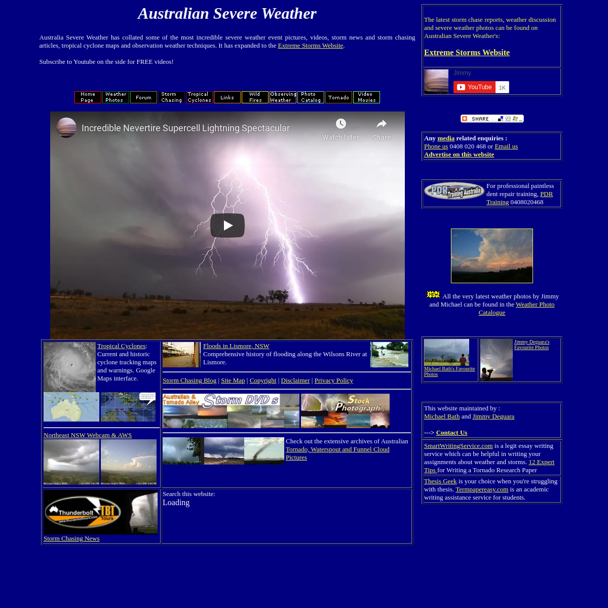
JULY 2002 TO JUNE 2003 TROPICAL CYCLONES IN THE SOUTH BoM data obtained from the Bureau of Meteorology, Melbourne JTWC data obtained from the Naval Pacific Meteorology and Oceanography / Joint Typhoon Warning Centre, Hawaii . Historical Season Maps for all seasons that data is available. Plotting Information about the track maps on this website. Also includes southern hemisphere TC regions and BoM TC intensity classification scale. TROPICAL CYCLONE IMPACTS ALONG THE AUSTRALIAN EAST … 16 Mar 1875 Gales and heavy rain at Maryborough. Verandahs were blown down. A vessel at sea reported:- SE gale off Wide Bay bar on the 16th. !7th E and stronger gale with huge seas washing boat off JULY 2017 TO JUNE 2018 TROPICAL CYCLONES IN THE SOUTHERN Southern Hemisphere Tropical Cyclones: July 2017 to June 2018 Tropical Cyclones in the Southern Hemisphere. 2017-18 Southern Hemisphere tropical cyclone season summary _AUSTRALIAN SEVERE WEATHER_ Australia Severe Weather has collated some of the most incredible severe weather event pictures, videos, storm news and storm chasing articles, tropical cyclone maps and observation weather techniques. It has expanded to the Extreme Storms Website.
Subscribe to Youtube on the side for FREE videos!Tropical Cyclones :
Current and historic cyclone tracking maps and warnings. Google Mapsinterface.
------------------------- Northeast NSW Webcam & AWS Floods in Lismore, NSW Comprehensive history of flooding along the Wilsons River at Lismore. ------------------------- Storm Chasing Blog | Site Map | Copyright | Disclaimer | Privacy Policy ------------------------- ------------------------- Check out the extensive archives of Australian Tornado, Waterspout and Funnel Cloud PicturesStorm
Chasing News Search this website:Loading
The latest storm chase reports, weather discussion and severe weather photos can be found on Australian Severe Weather's: EXTREME STORMS WEBSITE ANY MEDIA RELATED ENQUIRIES : Phone us 0408 020 468 or Email us ADVERTISE ON THIS WEBSITEFor professional
paintless dent repair training, PDR Training0408020468
All the very latest
weather photos by Jimmy and Michael can be found in the Weather PhotoCatalogue
Michael Bath's Favourite PhotosJimmy Deguara's
Favourite Photos
This website maintained by : Michael Bath and Jimmy Deguara---> CONTACT US
SmartWritingService.com is a legit essay writing service which can be helpful in writing your assignments about weather and storms. 12 Expert Tips for Writing a Tornado Research Paper Thesis Geek is your choice when you're struggling with thesis. Termpapereasy.com is an academic writing assistance service for students.Details
3