2
More Annotations


6


1
Favourite Annotations


6


6
Text
WHAT TO PACK FOR OUTBACK AUSTRALIA: AN ESSENTIAL GUIDE Broad Brimmed Hat: The one thing you do need to pack for outback Australia even in winter is a broad brimmed hat. We’ll let you in on a secret: you don’t have spend $100 to buy one of those Crocodile Dundee-type hats to visit the outback. Any broad brimmed hat will do. A broad brimmed hat is essential. BEGINNER'S GUIDE TO OUTBACK VEHICLE PREPARATION To help you out, I’ve written this no-nonsense, beginner’s guide to outback vehicle preparation. 1. Get your vehicle serviced. About three to four weeks before you go, have your vehicle professionally serviced. We ALWAYS do before any trip longer than a weekend. OUTBACK MAPS: WHAT WE USE & RECOMMEND Topographic maps (Aussies call them ‘topo’ maps for short), are what you’ll absolutely need if you’re hiking off track or driving off road. Topo maps come in a range of scales. In some places, you can get them as detailed as 1:2500, but that won’t be anywhere in the outback. Most of the topo mapsheets we use are 1:250 000 or 1:125 000. THE SOLO WOMAN'S GUIDE TO OUTBACK ROAD TRIPS Recommended Driving Time: 16 hours – at least ONE overnight stop is recommended. Estimated Fuel Cost: $367 calculated at 11 litres per 100km, and a cost of $2.20 per litre for fuel. Fuel, food, accommodation: Port Augusta, Pimba, Glendambo, Coober THE OODNADATTA TRACK: A COMPLETE GUIDE Outback Traveller’s Guide: Oodnadatta Track Map. This series of maps is the most detailed (apart from AUSLIG topographic maps), and comes in a hard-wearing spiral bound booklet. The maps are strip maps, which include details like creek crossings, grids and where bulldust ruts are located. The map book is around $23 AUD. EXPLORING THE GAWLER RANGES The Gawler Ranges are located about 600km from Adelaide and 250 km from Port Augusta. Access to the Park is from Iron Knob and Kimba in the south-east, Wudinna in the south, Minippa in the south west. For more adventure, drive down from Kingooyna and Lake Gairdner in the north. Recommended vehicles: CAMPING AT DALHOUSIE SPRINGS Alternatives to Camping at Dalhousie Springs. Thankfully, there’s a much quieter camping area only 10 minutes’ drive from Dalhousie, called 3 O’Clock Creek. This is our ‘secret’ camping spot! 3 O’Clock Creek is a shady, bush camping area, where you can enjoy the serenity of the desert after escaping from the Dalhousie crowds. KINGS CANYON RIM WALK Kings Canyon’s Most Spectacular Walk. Of all the possible Kings Canyon hiking you could do, the Kings Canyon Rim Walk is the most famous and most spectacular.. The Rim Walk is six kilometres in length, and suitable for relatively fit walkers who are able to take on an initial climb up about a thousand (1000) steps to the top of the
Canyon.
40+ AMAZING AYERS ROCK FACTSKINGS CREEK WALK
The Kings Creek walk can be done at almost anytime of the year, because it’s cool and shady. However, if you choose to hike from October-April (summer time in Australia), remember it’s very, very hot: 38-42 degrees Celsius. That’s over 100F. If you’re doing theKings Creek Walk in
WHAT TO PACK FOR OUTBACK AUSTRALIA: AN ESSENTIAL GUIDE Broad Brimmed Hat: The one thing you do need to pack for outback Australia even in winter is a broad brimmed hat. We’ll let you in on a secret: you don’t have spend $100 to buy one of those Crocodile Dundee-type hats to visit the outback. Any broad brimmed hat will do. A broad brimmed hat is essential. BEGINNER'S GUIDE TO OUTBACK VEHICLE PREPARATION To help you out, I’ve written this no-nonsense, beginner’s guide to outback vehicle preparation. 1. Get your vehicle serviced. About three to four weeks before you go, have your vehicle professionally serviced. We ALWAYS do before any trip longer than a weekend. OUTBACK MAPS: WHAT WE USE & RECOMMEND Topographic maps (Aussies call them ‘topo’ maps for short), are what you’ll absolutely need if you’re hiking off track or driving off road. Topo maps come in a range of scales. In some places, you can get them as detailed as 1:2500, but that won’t be anywhere in the outback. Most of the topo mapsheets we use are 1:250 000 or 1:125 000. THE SOLO WOMAN'S GUIDE TO OUTBACK ROAD TRIPS Recommended Driving Time: 16 hours – at least ONE overnight stop is recommended. Estimated Fuel Cost: $367 calculated at 11 litres per 100km, and a cost of $2.20 per litre for fuel. Fuel, food, accommodation: Port Augusta, Pimba, Glendambo, Coober THE OODNADATTA TRACK: A COMPLETE GUIDE Outback Traveller’s Guide: Oodnadatta Track Map. This series of maps is the most detailed (apart from AUSLIG topographic maps), and comes in a hard-wearing spiral bound booklet. The maps are strip maps, which include details like creek crossings, grids and where bulldust ruts are located. The map book is around $23 AUD. THE SOLO WOMAN'S GUIDE TO OUTBACK ROAD TRIPS Recommended Driving Time: 16 hours – at least ONE overnight stop is recommended. Estimated Fuel Cost: $367 calculated at 11 litres per 100km, and a cost of $2.20 per litre for fuel. Fuel, food, accommodation: Port Augusta, Pimba, Glendambo, Coober THE OODNADATTA TRACK: A COMPLETE GUIDE Outback Traveller’s Guide: Oodnadatta Track Map. This series of maps is the most detailed (apart from AUSLIG topographic maps), and comes in a hard-wearing spiral bound booklet. The maps are strip maps, which include details like creek crossings, grids and where bulldust ruts are located. The map book is around $23 AUD. EXPLORING THE GAWLER RANGES The Gawler Ranges are located about 600km from Adelaide and 250 km from Port Augusta. Access to the Park is from Iron Knob and Kimba in the south-east, Wudinna in the south, Minippa in the south west. For more adventure, drive down from Kingooyna and Lake Gairdner in the north. Recommended vehicles: CAMPING AT DALHOUSIE SPRINGS Alternatives to Camping at Dalhousie Springs. Thankfully, there’s a much quieter camping area only 10 minutes’ drive from Dalhousie, called 3 O’Clock Creek. This is our ‘secret’ camping spot! 3 O’Clock Creek is a shady, bush camping area, where you can enjoy the serenity of the desert after escaping from the Dalhousie crowds. 40+ AMAZING AYERS ROCK FACTS 27. The Valley of the Winds walk (a MUST DO) is about 8 km long. Climate. 28. Like Alice Springs, Ayers Rock has an arid, semi-desert climate. 29. It’s dry and hot in the summer, and cool and dry in the winter. 30.The best time of the year to visit is from May-September (we reckon the BEST month is May). 31.OUTBACK AUSTRALIA
Every month we get emails from travellers astounded at the price of car hire in outback Australia. They come to us begging for a solution to their dilemma: they want to hire a 4WD to see the outback and they can’t believe how expensive it is.. Sadly, most of these people are planning to visit Ayers Rock or Alice Springs – and you don’t needa 4WD for either.
KINGS CREEK WALK
The Kings Creek walk can be done at almost anytime of the year, because it’s cool and shady. However, if you choose to hike from October-April (summer time in Australia), remember it’s very, very hot: 38-42 degrees Celsius. That’s over 100F. If you’re doing theKings Creek Walk in
HOW TO GET FREE OUTBACK MAPS 2. Once you’ve downloaded the app, open it and go to the store. This is the store screen: 3. Click on the green ‘FIND MAPS’ button. 4. Type in the name of a location for which you want maps. In the example, I wanted maps of the north Tanami Desert, so I typed in‘Balgo’
PARACHILNA - FOSSILS, FAME & FERALS - TRAVEL OUTBACK AUSTRALIA Reg Sprigg, well known geologist who’s been written about in this book by Kristin Wiedenbach, was prospecting around the old Ediacara mine in 1946 and found the fossilised remains of an entire community of complex, soft-bodied sea creatures.. This was the first discovery of such a complete fossil community, anywhere in the world. DOBINSONS SUSPENSION DOBINSONS SUSPENSION. Yes, you guessed it, the suspension on your vehicle can make or break a trip. Many of the blogs I have written have been on vehicle preparation. In these blogs I talk about loading up our vehicles with all the stuff that we take away with us when travelling the outback. I also mention the significance of notoverloading
WHAT TO PACK FOR OUTBACK AUSTRALIA: AN ESSENTIAL GUIDE Broad Brimmed Hat: The one thing you do need to pack for outback Australia even in winter is a broad brimmed hat. We’ll let you in on a secret: you don’t have spend $100 to buy one of those Crocodile Dundee-type hats to visit the outback. Any broad brimmed hat will do. A broad brimmed hat is essential. BEGINNER'S GUIDE TO OUTBACK VEHICLE PREPARATION To help you out, I’ve written this no-nonsense, beginner’s guide to outback vehicle preparation. 1. Get your vehicle serviced. About three to four weeks before you go, have your vehicle professionally serviced. We ALWAYS do before any trip longer than a weekend. THE SOLO WOMAN'S GUIDE TO OUTBACK ROAD TRIPS Recommended Driving Time: 16 hours – at least ONE overnight stop is recommended. Estimated Fuel Cost: $367 calculated at 11 litres per 100km, and a cost of $2.20 per litre for fuel. Fuel, food, accommodation: Port Augusta, Pimba, Glendambo, Coober THE OODNADATTA TRACK: A COMPLETE GUIDE Outback Traveller’s Guide: Oodnadatta Track Map. This series of maps is the most detailed (apart from AUSLIG topographic maps), and comes in a hard-wearing spiral bound booklet. The maps are strip maps, which include details like creek crossings, grids and where bulldust ruts are located. The map book is around $23 AUD. OUTBACK MAPS: WHAT WE USE & RECOMMEND Topographic maps (Aussies call them ‘topo’ maps for short), are what you’ll absolutely need if you’re hiking off track or driving off road. Topo maps come in a range of scales. In some places, you can get them as detailed as 1:2500, but that won’t be anywhere in the outback. Most of the topo mapsheets we use are 1:250 000 or 1:125 000. CAMPING AT DALHOUSIE SPRINGS Alternatives to Camping at Dalhousie Springs. Thankfully, there’s a much quieter camping area only 10 minutes’ drive from Dalhousie, called 3 O’Clock Creek. This is our ‘secret’ camping spot! 3 O’Clock Creek is a shady, bush camping area, where you can enjoy the serenity of the desert after escaping from the Dalhousie crowds. 40+ AMAZING AYERS ROCK FACTS THE OUTBACK RANGER'S GUIDE TO TYRE PRESSURES Drop your pressures on unsealed gravelly roads, especially if you’re going to spend some time on them. Pressure increases when your tyres get hot and, while this is perfectly normal, this is the reason that it’s best to lower the pressure on dirt. It’s also why you check them cold. You’ll get an accurate reading. HOW TO GET FREE OUTBACK MAPS 2. Once you’ve downloaded the app, open it and go to the store. This is the store screen: 3. Click on the green ‘FIND MAPS’ button. 4. Type in the name of a location for which you want maps. In the example, I wanted maps of the north Tanami Desert, so I typed in‘Balgo’
KINGS CREEK WALK
The Kings Creek walk can be done at almost anytime of the year, because it’s cool and shady. However, if you choose to hike from October-April (summer time in Australia), remember it’s very, very hot: 38-42 degrees Celsius. That’s over 100F. If you’re doing theKings Creek Walk in
OUTBACK MAPS: WHAT WE USE & RECOMMEND Topographic maps (Aussies call them ‘topo’ maps for short), are what you’ll absolutely need if you’re hiking off track or driving off road. Topo maps come in a range of scales. In some places, you can get them as detailed as 1:2500, but that won’t be anywhere in the outback. Most of the topo mapsheets we use are 1:250 000 or 1:125 000. THE OODNADATTA TRACK: A COMPLETE GUIDE Outback Traveller’s Guide: Oodnadatta Track Map. This series of maps is the most detailed (apart from AUSLIG topographic maps), and comes in a hard-wearing spiral bound booklet. The maps are strip maps, which include details like creek crossings, grids and where bulldust ruts are located. The map book is around $23 AUD. HOW TO GET FREE OUTBACK MAPS 2. Once you’ve downloaded the app, open it and go to the store. This is the store screen: 3. Click on the green ‘FIND MAPS’ button. 4. Type in the name of a location for which you want maps. In the example, I wanted maps of the north Tanami Desert, so I typed in‘Balgo’
OUTBACK AUSTRALIA
Every month we get emails from travellers astounded at the price of car hire in outback Australia. They come to us begging for a solution to their dilemma: they want to hire a 4WD to see the outback and they can’t believe how expensive it is.. Sadly, most of these people are planning to visit Ayers Rock or Alice Springs – and you don’t needa 4WD for either.
KINGS CANYON RIM WALK Kings Canyon’s Most Spectacular Walk. Of all the possible Kings Canyon hiking you could do, the Kings Canyon Rim Walk is the most famous and most spectacular.. The Rim Walk is six kilometres in length, and suitable for relatively fit walkers who are able to take on an initial climb up about a thousand (1000) steps to the top of theCanyon.
AYERS ROCK WEATHER
Temperatures. Weather at Uluru can be extreme. Ayers Rock temperatures average 37-40C in summer and 18-20C in winter. However, summer temperatures in Desert of 45C have been recorded. As with most places in the Outback, January and February are the hottest months of the year. July is generally the coolest month Uluru Kata Tjuta NationalPark.
EAST MACDONNELL RANGES The East MacDonnell Ranges stretch for 150km east of Alice Springs. They’re really easy to get to. You just head south from Alice Springs through Heavitree Gap for about 2km and then turn onto the Ross Highway (you’ll go over a bridge across the usually dry Todd River, and then turn right at a roundabout). View East MacDonnellNational
DULCIE RANGES NATIONAL PARK It was 10:30 at night and we were bogged. My first visit to the Dulcie Ranges National Park wasn’t going too well We weren’t entirely sure where we were, and the troopy (that’s Territorian for Toyota Troop Carrier) in front of me had just got ‘hung up’ trying to cross a steep erosion gully. DOBINSONS SUSPENSION DOBINSONS SUSPENSION. Yes, you guessed it, the suspension on your vehicle can make or break a trip. Many of the blogs I have written have been on vehicle preparation. In these blogs I talk about loading up our vehicles with all the stuff that we take away with us when travelling the outback. I also mention the significance of notoverloading
OUTBACK COMMUNICATION: INSTALLING THE GME TX3350 UHF CB RADIO Ok, one other thing I haven’t mentioned is that with any good radio you need an equally good antenna. I matched the GME TX3350 with an AE4018WK2 GME aerial, which is a white, fibreglass whip with a chrome elevated feed and a stainless steel spring base. WHAT TO PACK FOR OUTBACK AUSTRALIA: AN ESSENTIAL GUIDE Broad Brimmed Hat: The one thing you do need to pack for outback Australia even in winter is a broad brimmed hat. We’ll let you in on a secret: you don’t have spend $100 to buy one of those Crocodile Dundee-type hats to visit the outback. Any broad brimmed hat will do. A broad brimmed hat is essential.HIKING IN AUSTRALIA
The Outback is an awesome place to hike and camp! This is us, standing on top of Mt Zeil. It’s the highest mountain in the Northern Territory. It’s just one of the little known, challenging hikes you can take in Outback Australia. Tracks, Trails, Gear & Equipment. BEGINNER'S GUIDE TO OUTBACK VEHICLE PREPARATION To help you out, I’ve written this no-nonsense, beginner’s guide to outback vehicle preparation. 1. Get your vehicle serviced. About three to four weeks before you go, have your vehicle professionally serviced. We ALWAYS do before any trip longer than a weekend. THE SOLO WOMAN'S GUIDE TO OUTBACK ROAD TRIPS Recommended Driving Time: 16 hours – at least ONE overnight stop is recommended. Estimated Fuel Cost: $367 calculated at 11 litres per 100km, and a cost of $2.20 per litre for fuel. Fuel, food, accommodation: Port Augusta, Pimba, Glendambo, Coober OUTBACK MAPS: WHAT WE USE & RECOMMEND Topographic maps (Aussies call them ‘topo’ maps for short), are what you’ll absolutely need if you’re hiking off track or driving off road. Topo maps come in a range of scales. In some places, you can get them as detailed as 1:2500, but that won’t be anywhere in the outback. Most of the topo mapsheets we use are 1:250 000 or 1:125 000. CAMPING AT DALHOUSIE SPRINGS Alternatives to Camping at Dalhousie Springs. Thankfully, there’s a much quieter camping area only 10 minutes’ drive from Dalhousie, called 3 O’Clock Creek. This is our ‘secret’ camping spot! 3 O’Clock Creek is a shady, bush camping area, where you can enjoy the serenity of the desert after escaping from the Dalhousie crowds. 40+ AMAZING AYERS ROCK FACTSKINGS CREEK WALK
The Kings Creek walk can be done at almost anytime of the year, because it’s cool and shady. However, if you choose to hike from October-April (summer time in Australia), remember it’s very, very hot: 38-42 degrees Celsius. That’s over 100F. If you’re doing theKings Creek Walk in
THE OUTBACK RANGER'S GUIDE TO TYRE PRESSURES Drop your pressures on unsealed gravelly roads, especially if you’re going to spend some time on them. Pressure increases when your tyres get hot and, while this is perfectly normal, this is the reason that it’s best to lower the pressure on dirt. It’s also why you check them cold. You’ll get an accurate reading.OUTBACK AUSTRALIA
Every month we get emails from travellers astounded at the price of car hire in outback Australia. They come to us begging for a solution to their dilemma: they want to hire a 4WD to see the outback and they can’t believe how expensive it is.. Sadly, most of these people are planning to visit Ayers Rock or Alice Springs – and you don’t needa 4WD for either.
WHAT TO PACK FOR OUTBACK AUSTRALIA: AN ESSENTIAL GUIDE Broad Brimmed Hat: The one thing you do need to pack for outback Australia even in winter is a broad brimmed hat. We’ll let you in on a secret: you don’t have spend $100 to buy one of those Crocodile Dundee-type hats to visit the outback. Any broad brimmed hat will do. A broad brimmed hat is essential.HIKING IN AUSTRALIA
The Outback is an awesome place to hike and camp! This is us, standing on top of Mt Zeil. It’s the highest mountain in the Northern Territory. It’s just one of the little known, challenging hikes you can take in Outback Australia. Tracks, Trails, Gear & Equipment. BEGINNER'S GUIDE TO OUTBACK VEHICLE PREPARATION To help you out, I’ve written this no-nonsense, beginner’s guide to outback vehicle preparation. 1. Get your vehicle serviced. About three to four weeks before you go, have your vehicle professionally serviced. We ALWAYS do before any trip longer than a weekend. THE SOLO WOMAN'S GUIDE TO OUTBACK ROAD TRIPS Recommended Driving Time: 16 hours – at least ONE overnight stop is recommended. Estimated Fuel Cost: $367 calculated at 11 litres per 100km, and a cost of $2.20 per litre for fuel. Fuel, food, accommodation: Port Augusta, Pimba, Glendambo, Coober OUTBACK MAPS: WHAT WE USE & RECOMMEND Topographic maps (Aussies call them ‘topo’ maps for short), are what you’ll absolutely need if you’re hiking off track or driving off road. Topo maps come in a range of scales. In some places, you can get them as detailed as 1:2500, but that won’t be anywhere in the outback. Most of the topo mapsheets we use are 1:250 000 or 1:125 000. CAMPING AT DALHOUSIE SPRINGS Alternatives to Camping at Dalhousie Springs. Thankfully, there’s a much quieter camping area only 10 minutes’ drive from Dalhousie, called 3 O’Clock Creek. This is our ‘secret’ camping spot! 3 O’Clock Creek is a shady, bush camping area, where you can enjoy the serenity of the desert after escaping from the Dalhousie crowds. 40+ AMAZING AYERS ROCK FACTSKINGS CREEK WALK
The Kings Creek walk can be done at almost anytime of the year, because it’s cool and shady. However, if you choose to hike from October-April (summer time in Australia), remember it’s very, very hot: 38-42 degrees Celsius. That’s over 100F. If you’re doing theKings Creek Walk in
THE OUTBACK RANGER'S GUIDE TO TYRE PRESSURES Drop your pressures on unsealed gravelly roads, especially if you’re going to spend some time on them. Pressure increases when your tyres get hot and, while this is perfectly normal, this is the reason that it’s best to lower the pressure on dirt. It’s also why you check them cold. You’ll get an accurate reading.OUTBACK AUSTRALIA
Every month we get emails from travellers astounded at the price of car hire in outback Australia. They come to us begging for a solution to their dilemma: they want to hire a 4WD to see the outback and they can’t believe how expensive it is.. Sadly, most of these people are planning to visit Ayers Rock or Alice Springs – and you don’t needa 4WD for either.
HIKING IN AUSTRALIA
The Outback is an awesome place to hike and camp! This is us, standing on top of Mt Zeil. It’s the highest mountain in the Northern Territory. It’s just one of the little known, challenging hikes you can take in Outback Australia. Tracks, Trails, Gear & Equipment.OUTBACK CAR HIRE
This is a heavy charge slapped on unsuspecting tourists who pick up their rental car in one location and then return it in another. In the outback, this fee will cost you a hefty $330. That is OUTRAGEOUS. With some companies, you can avoid this fee entirely by hiring your vehicle for 3 days instead of 2. OUTBACK MAPS: WHAT WE USE & RECOMMEND Topographic maps (Aussies call them ‘topo’ maps for short), are what you’ll absolutely need if you’re hiking off track or driving off road. Topo maps come in a range of scales. In some places, you can get them as detailed as 1:2500, but that won’t be anywhere in the outback. Most of the topo mapsheets we use are 1:250 000 or 1:125 000. 40+ AMAZING AYERS ROCK FACTS 27. The Valley of the Winds walk (a MUST DO) is about 8 km long. Climate. 28. Like Alice Springs, Ayers Rock has an arid, semi-desert climate. 29. It’s dry and hot in the summer, and cool and dry in the winter. 30.The best time of the year to visit is from May-September (we reckon the BEST month is May). 31.OUTBACK AUSTRALIA
Every month we get emails from travellers astounded at the price of car hire in outback Australia. They come to us begging for a solution to their dilemma: they want to hire a 4WD to see the outback and they can’t believe how expensive it is.. Sadly, most of these people are planning to visit Ayers Rock or Alice Springs – and you don’t needa 4WD for either.
HOW TO GET FREE OUTBACK MAPS 2. Once you’ve downloaded the app, open it and go to the store. This is the store screen: 3. Click on the green ‘FIND MAPS’ button. 4. Type in the name of a location for which you want maps. In the example, I wanted maps of the north Tanami Desert, so I typed in‘Balgo’
PALM VALLEY NT- FINKE GORGE NATIONAL PARK Palm Valley, located within Finke Gorge National Park is one of the most impressive places in central Australia. Finke Gorge National Park covers an area of 46,000 hectares.. Apart from the adventure of driving along the oldest river in the world, Palm Valley is a maze of sandstone amphitheatres, pinnacles and gorges and is home to the Red Cabbage Palm after which the valley is named. OODNADATTA TRACK ROAD CONDITIONS Visit Transport South Australia’s Oodnadatta track road conditions page by clicking here. The Pink Roadhouse is another excellent source of local advice about road conditions on the Oodnadatta Track. You can phone them toll free from anywhere in Australia on 1800 802 074 and find out the latest info on EAST MACDONNELL RANGES The East MacDonnell Ranges stretch for 150km east of Alice Springs. They’re really easy to get to. You just head south from Alice Springs through Heavitree Gap for about 2km and then turn onto the Ross Highway (you’ll go over a bridge across the usually dry Todd River, and then turn right at a roundabout). View East MacDonnellNational
GLASS GORGE FLINDERS RANGES TRIP REPORT Glass Gorge, Flinders Ranges: An Unexpected Adventure. We ended up on the Glass Gorge Scenic Route in the Flinders Ranges by accident. “I think it’s this way”. We looked at each other and shrugged, and drove out of Blinman. Of course, it seemed like we were going the right way at the time. It was a sleepy Sunday morning. WHAT TO PACK FOR OUTBACK AUSTRALIA: AN ESSENTIAL GUIDEALICE SPRINGS AUSTRALIAALICE SPRINGS AUSTRALIA BASEALICE SPRINGS AUSTRALIA FIRESALICE SPRINGS AUSTRALIA NEWS Broad Brimmed Hat: The one thing you do need to pack for outback Australia even in winter is a broad brimmed hat. We’ll let you in on a secret: you don’t have spend $100 to buy one of those Crocodile Dundee-type hats to visit the outback. Any broad brimmed hat will do. A broad brimmed hat is essential. THE SOLO WOMAN'S GUIDE TO OUTBACK ROAD TRIPS Recommended Driving Time: 16 hours – at least ONE overnight stop is recommended. Estimated Fuel Cost: $367 calculated at 11 litres per 100km, and a cost of $2.20 per litre for fuel. Fuel, food, accommodation: Port Augusta, Pimba, Glendambo, Coober BEGINNER'S GUIDE TO OUTBACK VEHICLE PREPARATIONAUSTRALIAN OUTBACK SAFARIAUSTRALIA OUTBACK CLOTHING FOR MENOUTBACK AUSTRALIA MAPAFRICAN SAFARI VEHICLEOPEN SAFARI VEHICLE To help you out, I’ve written this no-nonsense, beginner’s guide to outback vehicle preparation. 1. Get your vehicle serviced. About three to four weeks before you go, have your vehicle professionally serviced. We ALWAYS do before any trip longer than a weekend. CAMPING AT DALHOUSIE SPRINGS Alternatives to Camping at Dalhousie Springs. Thankfully, there’s a much quieter camping area only 10 minutes’ drive from Dalhousie, called 3 O’Clock Creek. This is our ‘secret’ camping spot! 3 O’Clock Creek is a shady, bush camping area, where you can enjoy the serenity of the desert after escaping from the Dalhousie crowds. PALM VALLEY NT- FINKE GORGE NATIONAL PARKSEE MORE ON TRAVELOUTBACKAUSTRALIA.COMPALM VALLEY ACADEMYPALM VALLEY ANIMAL SHELTERPALM VALLEY APARTMENTS ROUND ROCKPALM VALLEY CHURCHPALM VALLEY CHURCH GOODYEARZILLOW PALM VALLEY FL 40+ AMAZING AYERS ROCK FACTSAYERS ROCK WEATHER
KINGS CREEK WALK
The Kings Creek walk can be done at almost anytime of the year, because it’s cool and shady. However, if you choose to hike from October-April (summer time in Australia), remember it’s very, very hot: 38-42 degrees Celsius. That’s over 100F. If you’re doing theKings Creek Walk in
OODNADATTA TRACK ROAD CONDITIONS Visit Transport South Australia’s Oodnadatta track road conditions page by clicking here. The Pink Roadhouse is another excellent source of local advice about road conditions on the Oodnadatta Track. You can phone them toll free from anywhere in Australia on 1800 802 074 and find out the latest info on ITECH2000A MULTIFUNCTIONAL JUMP STARTER The iTECH2000A also allows you to run your 12v fridge, 12v TV, 12v LED lights directly from the device and at the same time. You can also charge your phone, tablet, camera or other wireless and USB devises. The iTECH2000A has one QC 3.0 USB, a normal port and even has a brightLED torch.
WHAT TO PACK FOR OUTBACK AUSTRALIA: AN ESSENTIAL GUIDEALICE SPRINGS AUSTRALIAALICE SPRINGS AUSTRALIA BASEALICE SPRINGS AUSTRALIA FIRESALICE SPRINGS AUSTRALIA NEWS Broad Brimmed Hat: The one thing you do need to pack for outback Australia even in winter is a broad brimmed hat. We’ll let you in on a secret: you don’t have spend $100 to buy one of those Crocodile Dundee-type hats to visit the outback. Any broad brimmed hat will do. A broad brimmed hat is essential. THE SOLO WOMAN'S GUIDE TO OUTBACK ROAD TRIPS Recommended Driving Time: 16 hours – at least ONE overnight stop is recommended. Estimated Fuel Cost: $367 calculated at 11 litres per 100km, and a cost of $2.20 per litre for fuel. Fuel, food, accommodation: Port Augusta, Pimba, Glendambo, Coober BEGINNER'S GUIDE TO OUTBACK VEHICLE PREPARATIONAUSTRALIAN OUTBACK SAFARIAUSTRALIA OUTBACK CLOTHING FOR MENOUTBACK AUSTRALIA MAPAFRICAN SAFARI VEHICLEOPEN SAFARI VEHICLE To help you out, I’ve written this no-nonsense, beginner’s guide to outback vehicle preparation. 1. Get your vehicle serviced. About three to four weeks before you go, have your vehicle professionally serviced. We ALWAYS do before any trip longer than a weekend. CAMPING AT DALHOUSIE SPRINGS Alternatives to Camping at Dalhousie Springs. Thankfully, there’s a much quieter camping area only 10 minutes’ drive from Dalhousie, called 3 O’Clock Creek. This is our ‘secret’ camping spot! 3 O’Clock Creek is a shady, bush camping area, where you can enjoy the serenity of the desert after escaping from the Dalhousie crowds. PALM VALLEY NT- FINKE GORGE NATIONAL PARKSEE MORE ON TRAVELOUTBACKAUSTRALIA.COMPALM VALLEY ACADEMYPALM VALLEY ANIMAL SHELTERPALM VALLEY APARTMENTS ROUND ROCKPALM VALLEY CHURCHPALM VALLEY CHURCH GOODYEARZILLOW PALM VALLEY FL 40+ AMAZING AYERS ROCK FACTSAYERS ROCK WEATHER
KINGS CREEK WALK
The Kings Creek walk can be done at almost anytime of the year, because it’s cool and shady. However, if you choose to hike from October-April (summer time in Australia), remember it’s very, very hot: 38-42 degrees Celsius. That’s over 100F. If you’re doing theKings Creek Walk in
OODNADATTA TRACK ROAD CONDITIONS Visit Transport South Australia’s Oodnadatta track road conditions page by clicking here. The Pink Roadhouse is another excellent source of local advice about road conditions on the Oodnadatta Track. You can phone them toll free from anywhere in Australia on 1800 802 074 and find out the latest info onOUTBACK CAR HIRE
This is a heavy charge slapped on unsuspecting tourists who pick up their rental car in one location and then return it in another. In the outback, this fee will cost you a hefty $330. That is OUTRAGEOUS. With some companies, you can avoid this fee entirely by hiring your vehicle for 3 days instead of 2.HIKING IN AUSTRALIA
The Outback is an awesome place to hike and camp! This is us, standing on top of Mt Zeil. It’s the highest mountain in the Northern Territory. It’s just one of the little known, challenging hikes you can take in Outback Australia. Tracks, Trails, Gear & Equipment. BEGINNER'S GUIDE TO OUTBACK VEHICLE PREPARATION To help you out, I’ve written this no-nonsense, beginner’s guide to outback vehicle preparation. 1. Get your vehicle serviced. About three to four weeks before you go, have your vehicle professionally serviced. We ALWAYS do before any trip longer than a weekend. THE OODNADATTA TRACK: A COMPLETE GUIDE Outback Traveller’s Guide: Oodnadatta Track Map. This series of maps is the most detailed (apart from AUSLIG topographic maps), and comes in a hard-wearing spiral bound booklet. The maps are strip maps, which include details like creek crossings, grids and where bulldust ruts are located. The map book is around $23 AUD.AYERS ROCK WEATHER
Temperatures. Weather at Uluru can be extreme. Ayers Rock temperatures average 37-40C in summer and 18-20C in winter. However, summer temperatures in Desert of 45C have been recorded. As with most places in the Outback, January and February are the hottest months of the year. July is generally the coolest month Uluru Kata Tjuta NationalPark.
CAMPING AT KINGS CANYON Kings Canyon Camping Options. The aim of this page is to give you honest, local advice about Kings Canyon camping. As Gary was the manager of Watarrka (Kings Canyon) National Park for many years, he knows a thing or two about camping at Watarrka.. And we can tell you that options for Kings Canyon camping are a lot more limited than theyshould be!
OODNADATTA TRACK ROAD CONDITIONS Visit Transport South Australia’s Oodnadatta track road conditions page by clicking here. The Pink Roadhouse is another excellent source of local advice about road conditions on the Oodnadatta Track. You can phone them toll free from anywhere in Australia on 1800 802 074 and find out the latest info on 40+ AMAZING AYERS ROCK FACTS 27. The Valley of the Winds walk (a MUST DO) is about 8 km long. Climate. 28. Like Alice Springs, Ayers Rock has an arid, semi-desert climate. 29. It’s dry and hot in the summer, and cool and dry in the winter. 30.The best time of the year to visit is from May-September (we reckon the BEST month is May). 31. THE OUTBACK RANGER'S GUIDE TO TYRE PRESSURES Drop your pressures on unsealed gravelly roads, especially if you’re going to spend some time on them. Pressure increases when your tyres get hot and, while this is perfectly normal, this is the reason that it’s best to lower the pressure on dirt. It’s also why you check them cold. You’ll get an accurate reading. DOBINSONS SUSPENSION DOBINSONS SUSPENSION. Yes, you guessed it, the suspension on your vehicle can make or break a trip. Many of the blogs I have written have been on vehicle preparation. In these blogs I talk about loading up our vehicles with all the stuff that we take away with us when travelling the outback. I also mention the significance of notoverloading
__
* Home
* Blog
* About
* About Gary & Amanda * Partnering With Us* Contact Us
* Site Map
* Destination Guides* A-F
* Alice Springs
* Ayers Rock – Uluru* Birdsville
* Chambers Pillar, NT* Coober Pedy
* Dalhousie Springs
* Devils Marbles/ Karlu Karlu * Dulcie Ranges National Park * East MacDonnell Ranges* Farina, SA
* G-R
* Gawler Ranges – SA * Kalgoorlie – Boulder * Kings Canyon-Watarrka* Lake Ballard -WA
* Lake Eyre – Kati Thanda * Oodnadatta Track Guide * Owen Springs Reserve* Palm Valley
* Parachilna, SA
* Rainbow Valley
* Red Centre Way
* Ruby Gap Nature Park* S-Z
* Simpson Desert
* Standley Chasm
* Tennant Creek
* West MacDonnell National Park * Witjira National Park* Start Here
* Where is the outback? * What to Pack for Outback Australia * Best Ways of Getting to the Outback * Vehicle Preparation * 9 Ways to Get Around the Australian Outback * Outback Climate & Weather* Outback Maps
* Gear Reviews
* Safety Gear
* Book & Plan
*
5 Outback Books You Won’t Put Down*
Why we use Hema
Maps
*
100 Things to See in The Kimberley* Accommodation
* Outback Car Hire – Insider’s Guide* Travel Insurance
* See and Do
*
Great Southern Rail Journey*
100 Things to See in The Kimberley*
Motorbiking
Outback
* Aboriginal Culture * Hiking the Outback* National Parks
* Contact Us
__
*
*
*
*
__
* Home
* Blog
* About
* About Gary & Amanda * Partnering With Us* Contact Us
* Site Map
* Destination Guides* A-F
* Alice Springs
* Ayers Rock – Uluru* Birdsville
* Chambers Pillar, NT* Coober Pedy
* Dalhousie Springs
* Devils Marbles/ Karlu Karlu * Dulcie Ranges National Park * East MacDonnell Ranges* Farina, SA
* G-R
* Gawler Ranges – SA * Kalgoorlie – Boulder * Kings Canyon-Watarrka* Lake Ballard -WA
* Lake Eyre – Kati Thanda * Oodnadatta Track Guide * Owen Springs Reserve* Palm Valley
* Parachilna, SA
* Rainbow Valley
* Red Centre Way
* Ruby Gap Nature Park* S-Z
* Simpson Desert
* Standley Chasm
* Tennant Creek
* West MacDonnell National Park * Witjira National Park* Start Here
* Where is the outback? * What to Pack for Outback Australia * Best Ways of Getting to the Outback * Vehicle Preparation * 9 Ways to Get Around the Australian Outback * Outback Climate & Weather* Outback Maps
* Gear Reviews
* Safety Gear
* Book & Plan
*
5 Outback Books You Won’t Put Down*
Why we use Hema
Maps
*
100 Things to See in The Kimberley* Accommodation
* Outback Car Hire – Insider’s Guide* Travel Insurance
* See and Do
*
Great Southern Rail Journey*
100 Things to See in The Kimberley*
Motorbiking
Outback
* Aboriginal Culture * Hiking the Outback* National Parks
* Contact Us
*
South Australia
MALLEE SHAKEDOWN – EXPLORING A FORGOTTEN OUTBACK ROADRead More
*
Outback Tracks
, Simpson
Desert
MADIGAN LINE TRIP REPORT 2018Read More
*
Destinations
, Western
Australia
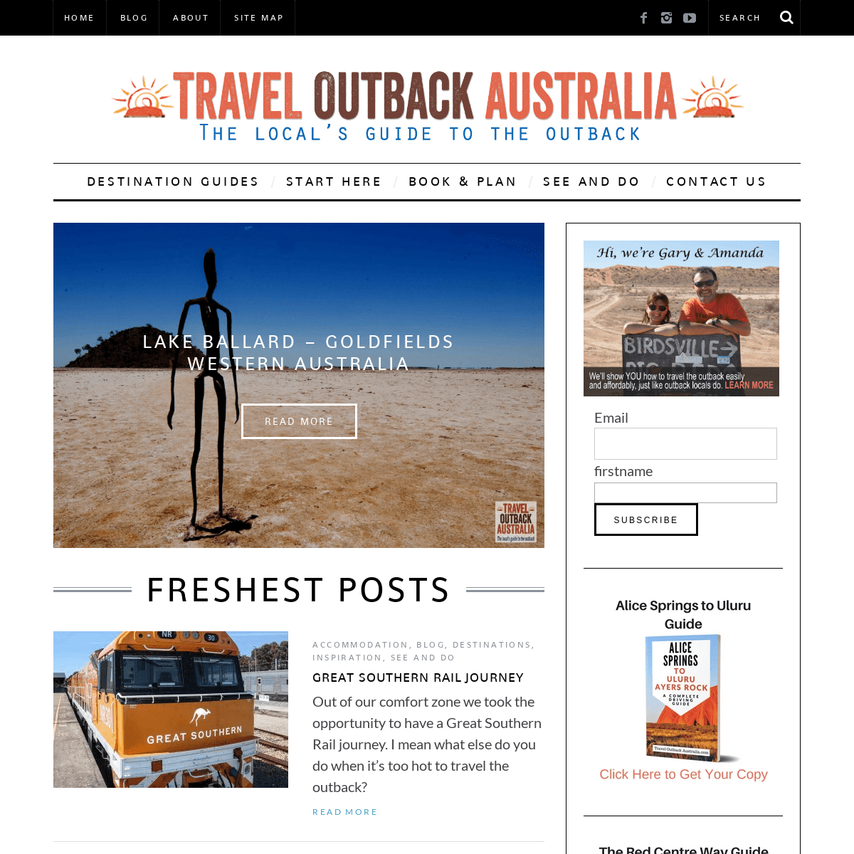
LAKE BALLARD – GOLDFIELDS WESTERN AUSTRALIARead More
*
Destinations
, Northern
Territory
CHAMBERS PILLAR – A COMPLETE TRAVEL GUIDERead More
*
South Australia
MALLEE SHAKEDOWN – EXPLORING A FORGOTTEN OUTBACK ROADRead More
*
Outback Tracks
, Simpson
Desert
MADIGAN LINE TRIP REPORT 2018Read More
* __
* __
FRESHEST POSTS
Accommodation
, Blog
, Destinations
,
Inspiration
, See and Do
GREAT SOUTHERN RAIL JOURNEY Out of our comfort zone we took the opportunity to have a Great Southern Rail journey. I mean what else do you do when it’s too hot to travel the outback?Read More
Destinations
,
Inspiration
25 SECRET OUTBACK NATIONAL PARKS Our top 25 SECRET outback national parks. Be inspired to explore the Australian outback more – AND discover the that there’s some outback in almost every state in Australia.Read More
Inspiration
, Trip
planning
5 OUTBACK BOOKS YOU WON’T PUT DOWN Are your outback travels over for the year and you’re in need of some inspiration? Or… Have you fallen in love with the outback…Read More
Blog , How to Plan
Your Trip
,
Outback Tracks
, Road
Trips , Trip
planning ,
Vehicle Preparation
WHY WE USE HEMA MAPS One key part of travelling the outback is knowing where you’re going. That’s why we use Hema maps. If you’re like us then you…Read More
GET INSPIRED
Accommodation
, Blog
, Destinations
,
Inspiration
, See and Do
GREAT SOUTHERN RAIL JOURNEY Out of our comfort zone we took the opportunity to have a Great Southern Rail journey. I mean what else do you do when it’s too hot to travel the outback?Destinations
,
Inspiration
25 SECRET OUTBACK NATIONAL PARKS Our top 25 SECRET outback national parks. Be inspired to explore the Australian outback more – AND discover the that there’s some outback in almost every state in Australia.Inspiration
, Trip
planning
5 OUTBACK BOOKS YOU WON’T PUT DOWN Are your outback travels over for the year and you’re in need of some inspiration? Or… Have you fallen in love with the outback…Blog ,
Destinations
,
Inspiration
, Road Trips
, See and Do
, Trip
planning ,
Western Australia
100 THINGS TO SEE IN THE KIMBERLEY The Kimberley still sits atop many traveller’s bucket list and many that travel there, travel back time and time again. In a land of…View The Category
DESTINATIONS
Accommodation
, Blog
, Destinations
,
Inspiration
, See and Do
GREAT SOUTHERN RAIL JOURNEY Out of our comfort zone we took the opportunity to have a Great Southern Rail journey. I mean what else do you do when it’s too hot to travel the outback?Destinations
,
Inspiration
25 SECRET OUTBACK NATIONAL PARKS Our top 25 SECRET outback national parks. Be inspired to explore the Australian outback more – AND discover the that there’s some outback in almost every state in Australia.Blog ,
Destinations
,
Inspiration
, Road Trips
, See and Do
, Trip
planning ,
Western Australia
100 THINGS TO SEE IN THE KIMBERLEY The Kimberley still sits atop many traveller’s bucket list and many that travel there, travel back time and time again. In a land of…Outback Tracks
, Simpson
Desert
MADIGAN LINE TRIP REPORT 2018 I’d dreamed about tackling the Madigan Line since first reading Crossing the Dead Heart almost 20 years ago: traverse the SimpsonDesert via the…
View The Category
Email firstname
* Outback Travel NewsPOPULAR POSTS
* _145_ Driving from Alice Springs to ... * _113_ Driving from Adelaide to Alice... * _83_ Living in Alice Springs: What&... * _82_ Oodnadatta Track Guide * _37_ Travel to Ayers RockHOME
BLOG
PARTNER WITH US
SITE MAP
CONTACT
PRIVACY POLICY
Copyright 2010-2017| Design by Amanda | Theme by ThemesindepBack to top __
Details
5