4
More Annotations


2


1
Favourite Annotations


1


3
Text
BRITAIN'S HIGHEST MOUNTAINS BY COUNTY Tables of Britain's tallest mountains by county (county tops). These are arranged into sortable lists by country. MOUNTAINS NEAR DOLGELLAU The mountain guide has 99 mountains listed in and around the town of Dolgellau. Bryn-y-gwin. Foel Faner. Mynydd Moel. Bryniau Glo. Foel Cynwch. Craig y Castell. Fedw Felen. Mynydd Gwerngraig. NORFOLK HILLS AND MOUNTAINS Norfolk hills & mountains. Map featuring Norfolk mountains. Click on pins to view mountain details. The mountain guide has 13 mountains listed in Norfolk, England. MOUNTAINS NEAR PENRITH The mountain guide has 68 mountains listed in and around the town of Penrith. Beacon Hill. Wan Fell. Brown Rigg. Lazonby Fell. Highbarn Hill. Lowther Park. Heughscar Hill. Quarrystone Bank. MOUNTAINS NEAR WINDERMERE Map featuring Windermere mountains. Click on pins to view mountain details The mountain guide has 99 mountains listed in and around the
town of Windermere.
MOCHRUM HILL
Mochrum Hill is the 12378th highest peak in the British Isles and the 7560th tallest in Scotland. MOUNTAINS NEAR KENDAL The mountain guide has 99 mountains listed in and around the town of Kendal. Castle Hill. Kendal Fell. Larkrigg Hill. Scout Scar. Scout Scar (Wainwright summit) Cunswick Scar. The Helm. Wellheads Hill.COLLOWAY HILL
Colloway Hill. mountain info. maps. weather. Colloway Hill is the 20460th highest peak in the British Isles and the 4440th tallest inEngland.
MUNROS IN THE APPLECROSS TO ACHNASHEEN REGION Munros in the Applecross to Achnasheen region. Map of Munros in the Applecross to Achnasheen region. Click on pins to view mountain details. The mountain guide has mountains listed.. CORBETTS IN THE MALLAIG TO FORT WILLIAM REGION Map of Corbetts in the Mallaig to Fort William region. Click on pins to view mountain details. BRITAIN'S HIGHEST MOUNTAINS BY COUNTY Tables of Britain's tallest mountains by county (county tops). These are arranged into sortable lists by country. MOUNTAINS NEAR DOLGELLAU The mountain guide has 99 mountains listed in and around the town of Dolgellau. Bryn-y-gwin. Foel Faner. Mynydd Moel. Bryniau Glo. Foel Cynwch. Craig y Castell. Fedw Felen. Mynydd Gwerngraig. NORFOLK HILLS AND MOUNTAINS Norfolk hills & mountains. Map featuring Norfolk mountains. Click on pins to view mountain details. The mountain guide has 13 mountains listed in Norfolk, England. MOUNTAINS NEAR PENRITH The mountain guide has 68 mountains listed in and around the town of Penrith. Beacon Hill. Wan Fell. Brown Rigg. Lazonby Fell. Highbarn Hill. Lowther Park. Heughscar Hill. Quarrystone Bank. MOUNTAINS NEAR WINDERMERE Map featuring Windermere mountains. Click on pins to view mountain details The mountain guide has 99 mountains listed in and around thetown of Windermere.
MOCHRUM HILL
Mochrum Hill is the 12378th highest peak in the British Isles and the 7560th tallest in Scotland. MOUNTAINS NEAR KENDAL The mountain guide has 99 mountains listed in and around the town of Kendal. Castle Hill. Kendal Fell. Larkrigg Hill. Scout Scar. Scout Scar (Wainwright summit) Cunswick Scar. The Helm. Wellheads Hill.COLLOWAY HILL
Colloway Hill. mountain info. maps. weather. Colloway Hill is the 20460th highest peak in the British Isles and the 4440th tallest inEngland.
MUNROS IN THE APPLECROSS TO ACHNASHEEN REGION Munros in the Applecross to Achnasheen region. Map of Munros in the Applecross to Achnasheen region. Click on pins to view mountain details. The mountain guide has mountains listed.. CORBETTS IN THE MALLAIG TO FORT WILLIAM REGION Map of Corbetts in the Mallaig to Fort William region. Click on pins to view mountain details. MOUNTAINS OF THE BRITISH ISLES The Mountain Guide. The purpose of the Mountain Guide is to list, classify and present the hills and mountains of the British Isles (which includes Ireland). HIGHEST MOUNTAINS IN BRITAIN Highest Mountains in the UK. The list below shows the mountains of the British Isles ordered by relative height. Only those over 600 metres (approx 2000ft) are featured in the list. BRITAIN'S HIGHEST MOUNTAINS BY COUNTY Tables of Britain's tallest mountains by county (county tops). These are arranged into sortable lists by country. STAFFORDSHIRE HILLS AND MOUNTAINS Map featuring Staffordshire mountains. Click on pins to view mountain details. The mountain guide has 102 mountains listed in Staffordshire, England. Alsagers Bank. Ashenough Hill. Ashley Heath. Badger's Hills. Bagot's Park. Banktop Hill. LANCASHIRE HILLS AND MOUNTAINS Click on pins to view mountain details. The mountain guide has 107 mountains listed in Lancashire, England. Ashurst's Beacon. Barnacre Moor. Baxton Fell. Beacon Fell. Beacon Hill. Birtle Hill. Black Hill. MOUNTAINS NEAR DOLGELLAU The mountain guide has 99 mountains listed in and around the town of Dolgellau. Bryn-y-gwin. Foel Faner. Mynydd Moel. Bryniau Glo. Foel Cynwch. Craig y Castell. Fedw Felen. Mynydd Gwerngraig. WARWICKSHIRE HILLS AND MOUNTAINS Warwickshire hills & mountains. Map featuring Warwickshire mountains. Click on pins to view mountain details. The mountain guide has 32 mountains listed in Warwickshire, England.THE BASTARD
The Bastard. mountain info. maps. weather. The Bastard is the 15231st highest peak in the British Isles and the 8905th tallest in Scotland. LAMMER LAW | SCOTLAND | THE MOUNTAIN GUIDE Lammer Law is the 5208th highest peak in the British Isles and the 3756th tallest in Scotland. NUTTALLS IN THE NORTH PENNINES REGION Map of Nuttalls in the North Pennines region. Click on pins to viewmountain details.
STAFFORDSHIRE HILLS AND MOUNTAINS Map featuring Staffordshire mountains. Click on pins to view mountain details. The mountain guide has 102 mountains listed in Staffordshire, England. Alsagers Bank. Ashenough Hill. Ashley Heath. Badger's Hills. Bagot's Park. Banktop Hill. DERBYSHIRE HILLS AND MOUNTAINS Map featuring Derbyshire mountains. Click on pins to view mountain details. The mountain guide has 141 mountains listed in Derbyshire, England. Abney Low. Aldery Cliff. MOUNTAINS NEAR WINDERMERE Map featuring Windermere mountains. Click on pins to view mountain details The mountain guide has 99 mountains listed in and around thetown of Windermere.
MOCHRUM HILL
Mochrum Hill is the 12378th highest peak in the British Isles and the 7560th tallest in Scotland.COLLOWAY HILL
Colloway Hill. mountain info. maps. weather. Colloway Hill is the 20460th highest peak in the British Isles and the 4440th tallest inEngland.
CAMP HILL PHOTOS
Camp Hill photos, Staffordshire. Maer Hills Maer Hills Notice mountainphotos
MOUNTAINS NEAR PEEBLES The mountain guide has 99 mountains listed in and around the town of Peebles. Ven Law. Mailingsland. Black Knowe. Newby Kipps. Cademuir Hill. Craig Head. Hamilton Hill. Castle Hill. MUNROS IN THE APPLECROSS TO ACHNASHEEN REGION Munros in the Applecross to Achnasheen region. Map of Munros in the Applecross to Achnasheen region. Click on pins to view mountain details. The mountain guide has mountains listed.. BEN A'AN | SCOTLANDWEATHER | THE MOUNTAIN GUIDE Ben A'an current weather (Wed May 26th 22:00) (Fair) 12°C / 54°F. Wind. WNW. 2 mph / 4 km/h. Rain. 0.0mm. Air pressure. CORBETTS IN THE MALLAIG TO FORT WILLIAM REGION Map of Corbetts in the Mallaig to Fort William region. Click on pins to view mountain details. STAFFORDSHIRE HILLS AND MOUNTAINS Map featuring Staffordshire mountains. Click on pins to view mountain details. The mountain guide has 102 mountains listed in Staffordshire, England. Alsagers Bank. Ashenough Hill. Ashley Heath. Badger's Hills. Bagot's Park. Banktop Hill. DERBYSHIRE HILLS AND MOUNTAINS Map featuring Derbyshire mountains. Click on pins to view mountain details. The mountain guide has 141 mountains listed in Derbyshire, England. Abney Low. Aldery Cliff. MOUNTAINS NEAR WINDERMERE Map featuring Windermere mountains. Click on pins to view mountain details The mountain guide has 99 mountains listed in and around thetown of Windermere.
MOCHRUM HILL
Mochrum Hill is the 12378th highest peak in the British Isles and the 7560th tallest in Scotland.COLLOWAY HILL
Colloway Hill. mountain info. maps. weather. Colloway Hill is the 20460th highest peak in the British Isles and the 4440th tallest inEngland.
CAMP HILL PHOTOS
Camp Hill photos, Staffordshire. Maer Hills Maer Hills Notice mountainphotos
MOUNTAINS NEAR PEEBLES The mountain guide has 99 mountains listed in and around the town of Peebles. Ven Law. Mailingsland. Black Knowe. Newby Kipps. Cademuir Hill. Craig Head. Hamilton Hill. Castle Hill. MUNROS IN THE APPLECROSS TO ACHNASHEEN REGION Munros in the Applecross to Achnasheen region. Map of Munros in the Applecross to Achnasheen region. Click on pins to view mountain details. The mountain guide has mountains listed.. BEN A'AN | SCOTLANDWEATHER | THE MOUNTAIN GUIDE Ben A'an current weather (Wed May 26th 22:00) (Fair) 12°C / 54°F. Wind. WNW. 2 mph / 4 km/h. Rain. 0.0mm. Air pressure. CORBETTS IN THE MALLAIG TO FORT WILLIAM REGION Map of Corbetts in the Mallaig to Fort William region. Click on pins to view mountain details. LANCASHIRE HILLS AND MOUNTAINS Click on pins to view mountain details. The mountain guide has 107 mountains listed in Lancashire, England. Ashurst's Beacon. Barnacre Moor. Baxton Fell. Beacon Fell. Beacon Hill. Birtle Hill. Black Hill. NORFOLK HILLS AND MOUNTAINS Norfolk hills & mountains. Map featuring Norfolk mountains. Click on pins to view mountain details. The mountain guide has 13 mountains listed in Norfolk, England. HEREFORDSHIRE HILLS AND MOUNTAINS Click on pins to view mountain details. The mountain guide has 146 mountains listed in Herefordshire, England. Aconbury Hill. Ashgrove Hill. Backbury Hill. Bagburrow Hill. Bank Farm Hill. Beacon Hill.Bearswood Common.
SHROPSHIRE HILLS AND MOUNTAINS Map featuring Shropshire mountains. Click on pins to view mountain details. The mountain guide has 178 mountains listed in Shropshire,England. Acton Bank
ABERDEENSHIRE HILLS AND MOUNTAINS Map featuring Aberdeenshire mountains. Click on pins to view mountain details. The mountain guide has 696 mountains listed in Aberdeenshire, Scotland. A'Chioch. Aitionn Hill. Allt Sowan Hill. An Creagan. An Sgarsoch. An Sgarsoch East Top. CLARE HILLS AND MOUNTAINS Clare hills & mountains. Map featuring Clare mountains. Click on pins to view mountain details. The mountain guide has 32 mountains listedin Clare, Ireland.
MOUNTAINS NEAR STIRLING The mountain guide has 38 mountains listed in and around the town of Stirling. Stirling Castle. King's Park. Abbey Craig. Craigforth. Touchadam Craig. Black Hill. Barr Wood Hill. Gallow Hill. MONAGHAN HILLS AND MOUNTAINS Monaghan hills & mountains. Map featuring Monaghan mountains. Click on pins to view mountain details.THE BASTARD
The Bastard. mountain info. maps. weather. The Bastard is the 15231st highest peak in the British Isles and the 8905th tallest in Scotland. IDLE HILL (WERNETH LOW) Hills and mountain guide to Idle Hill (Hu,2). Located near Hyde, England Idle Hill (Werneth Low) has a maximum elevation of 279.0m(915ft)
MOUNTAINS NEAR PENRITH The mountain guide has 68 mountains listed in and around the town of Penrith. Beacon Hill. Wan Fell. Brown Rigg. Lazonby Fell. Highbarn Hill. Lowther Park. Heughscar Hill. Quarrystone Bank. MOUNTAINS NEAR WINDERMERE Map featuring Windermere mountains. Click on pins to view mountain details The mountain guide has 99 mountains listed in and around thetown of Windermere.
MOUNTAINS NEAR PEEBLES The mountain guide has 99 mountains listed in and around the town of Peebles. Ven Law. Mailingsland. Black Knowe. Newby Kipps. Cademuir Hill. Craig Head. Hamilton Hill. Castle Hill. MOUNTAINS NEAR PERTH The mountain guide has 52 mountains listed in and around the town of Perth. Moncreiffe Island. Kinnoull Hill. Burghmuir. Mailer Hill. Deuchny Hill. Law of Dumbuils. Taymount. Glenearn Hill.MOCHRUM HILL
Mochrum Hill is the 12378th highest peak in the British Isles and the 7560th tallest in Scotland.COLLOWAY HILL
Colloway Hill. mountain info. maps. weather. Colloway Hill is the 20460th highest peak in the British Isles and the 4440th tallest inEngland.
CAMP HILL PHOTOS
Camp Hill photos, Staffordshire. Maer Hills Maer Hills Notice mountainphotos
THE BASTARD
The Bastard. mountain info. maps. weather. The Bastard is the 15231st highest peak in the British Isles and the 8905th tallest in Scotland. CLARE HILLS AND MOUNTAINS Clare hills & mountains. Map featuring Clare mountains. Click on pins to view mountain details. The mountain guide has 32 mountains listedin Clare, Ireland.
MUNROS IN THE APPLECROSS TO ACHNASHEEN REGION Munros in the Applecross to Achnasheen region. Map of Munros in the Applecross to Achnasheen region. Click on pins to view mountain details. The mountain guide has mountains listed.. MOUNTAINS NEAR PENRITH The mountain guide has 68 mountains listed in and around the town of Penrith. Beacon Hill. Wan Fell. Brown Rigg. Lazonby Fell. Highbarn Hill. Lowther Park. Heughscar Hill. Quarrystone Bank. MOUNTAINS NEAR WINDERMERE Map featuring Windermere mountains. Click on pins to view mountain details The mountain guide has 99 mountains listed in and around thetown of Windermere.
MOUNTAINS NEAR PEEBLES The mountain guide has 99 mountains listed in and around the town of Peebles. Ven Law. Mailingsland. Black Knowe. Newby Kipps. Cademuir Hill. Craig Head. Hamilton Hill. Castle Hill. MOUNTAINS NEAR PERTH The mountain guide has 52 mountains listed in and around the town of Perth. Moncreiffe Island. Kinnoull Hill. Burghmuir. Mailer Hill. Deuchny Hill. Law of Dumbuils. Taymount. Glenearn Hill.MOCHRUM HILL
Mochrum Hill is the 12378th highest peak in the British Isles and the 7560th tallest in Scotland.COLLOWAY HILL
Colloway Hill. mountain info. maps. weather. Colloway Hill is the 20460th highest peak in the British Isles and the 4440th tallest inEngland.
CAMP HILL PHOTOS
Camp Hill photos, Staffordshire. Maer Hills Maer Hills Notice mountainphotos
THE BASTARD
The Bastard. mountain info. maps. weather. The Bastard is the 15231st highest peak in the British Isles and the 8905th tallest in Scotland. CLARE HILLS AND MOUNTAINS Clare hills & mountains. Map featuring Clare mountains. Click on pins to view mountain details. The mountain guide has 32 mountains listedin Clare, Ireland.
MUNROS IN THE APPLECROSS TO ACHNASHEEN REGION Munros in the Applecross to Achnasheen region. Map of Munros in the Applecross to Achnasheen region. Click on pins to view mountain details. The mountain guide has mountains listed.. STAFFORDSHIRE HILLS AND MOUNTAINS Map featuring Staffordshire mountains. Click on pins to view mountain details. The mountain guide has 102 mountains listed in Staffordshire, England. Alsagers Bank. Ashenough Hill. Ashley Heath. Badger's Hills. Bagot's Park. Banktop Hill. DERBYSHIRE HILLS AND MOUNTAINS Map featuring Derbyshire mountains. Click on pins to view mountain details. The mountain guide has 141 mountains listed in Derbyshire, England. Abney Low. Aldery Cliff. MOUNTAINS NEAR DOLGELLAU The mountain guide has 99 mountains listed in and around the town of Dolgellau. Bryn-y-gwin. Foel Faner. Mynydd Moel. Bryniau Glo. Foel Cynwch. Craig y Castell. Fedw Felen. Mynydd Gwerngraig.CHASE END HILL
Chase End Hill. mountain info. maps. weather. Chase End Hill is the 15140th highest peak in the British Isles and the 2809th tallest inEngland.
MOUNTAINS NEAR PEEBLES The mountain guide has 99 mountains listed in and around the town of Peebles. Ven Law. Mailingsland. Black Knowe. Newby Kipps. Cademuir Hill. Craig Head. Hamilton Hill. Castle Hill. LEICESTERSHIRE HILLS AND MOUNTAINS Leicestershire hills & mountains. Map featuring Leicestershire mountains. Click on pins to view mountain details. The mountain guide has 31 mountains listed in Leicestershire, England. MOUNTAINS NEAR KESWICK The mountain guide has 99 mountains listed in and around the town of Keswick. Castlehead. Latrigg. Walla Crag. Skiddaw Little Man. Skiddaw - Lesser Man. Swinside. Shepherds Crag. Jenkin Hill. MOUNTAINS NEAR LEEDS Mountains near Leeds, England. Map featuring Leeds mountains. Click on pins to view mountain details. The mountain guide has 9 mountains listed in and around the town of Leeds. IDLE HILL (WERNETH LOW) Hills and mountain guide to Idle Hill (Hu,2). Located near Hyde, England Idle Hill (Werneth Low) has a maximum elevation of 279.0m(915ft)
PUMLUMON FAWR (PLYNLIMON) Hills and mountain guide to Pumlumon Fawr (Ma,Sim,Hew,N,CoH,CoU). Located near Machynlleth, Wales Pumlumon Fawr (Plynlimon) is part of the Pumlumon range and has a MOUNTAINS NEAR WINDERMERE Map featuring Windermere mountains. Click on pins to view mountain details The mountain guide has 99 mountains listed in and around thetown of Windermere.
MOUNTAINS NEAR PENRITH Map featuring Penrith mountains. Click on pins to view mountain details The mountain guide has 68 mountains listed in and around thetown of Penrith.
CAMP HILL PHOTOS
Camp Hill photos, Staffordshire. Maer Hills Maer Hills Notice mountainphotos
LEITRIM HILLS AND MOUNTAINS Map featuring Leitrim mountains. Click on pins to view mountain details. The mountain guide has 28 mountains listed in Leitrim,Ireland. Aganny Top
CLARE HILLS AND MOUNTAINS Map featuring Clare mountains. Click on pins to view mountain details. The mountain guide has 32 mountains listed in Clare, Ireland. AbbeyHill
COLLOWAY HILL
Hills and mountain guide to Colloway Hill (0). Located near Heysham, England Colloway Hill has a maximum elevation of 36.0m (118ft)MOCHRUM HILL
Hills and mountain guide to Mochrum Hill (Hu,2). Located near Maybole, Scotland Mochrum Hill has a maximum elevation of 270.0m (886ft) MUNROS IN THE APPLECROSS TO ACHNASHEEN REGION Map of Munros in the Applecross to Achnasheen region. Click on pins to view mountain details.THE BASTARD
Hills and mountain guide to The Bastard (1). Located near Campbeltown, Scotland The Bastard has a maximum elevation of 188.0m (617ft) DRUM | WALES | THE MOUNTAIN GUIDE Hills and mountain guide to Drum (Sim,Hew,N). Located near Penmaenmawr, Wales Drum is part of the Carneddau range and has a maximum elevation of 770.0m (2526ft) MOUNTAINS NEAR WINDERMERE Map featuring Windermere mountains. Click on pins to view mountain details The mountain guide has 99 mountains listed in and around thetown of Windermere.
MOUNTAINS NEAR PENRITH Map featuring Penrith mountains. Click on pins to view mountain details The mountain guide has 68 mountains listed in and around thetown of Penrith.
CAMP HILL PHOTOS
Camp Hill photos, Staffordshire. Maer Hills Maer Hills Notice mountainphotos
LEITRIM HILLS AND MOUNTAINS Map featuring Leitrim mountains. Click on pins to view mountain details. The mountain guide has 28 mountains listed in Leitrim,Ireland. Aganny Top
CLARE HILLS AND MOUNTAINS Map featuring Clare mountains. Click on pins to view mountain details. The mountain guide has 32 mountains listed in Clare, Ireland. AbbeyHill
COLLOWAY HILL
Hills and mountain guide to Colloway Hill (0). Located near Heysham, England Colloway Hill has a maximum elevation of 36.0m (118ft)MOCHRUM HILL
Hills and mountain guide to Mochrum Hill (Hu,2). Located near Maybole, Scotland Mochrum Hill has a maximum elevation of 270.0m (886ft) MUNROS IN THE APPLECROSS TO ACHNASHEEN REGION Map of Munros in the Applecross to Achnasheen region. Click on pins to view mountain details.THE BASTARD
Hills and mountain guide to The Bastard (1). Located near Campbeltown, Scotland The Bastard has a maximum elevation of 188.0m (617ft) DRUM | WALES | THE MOUNTAIN GUIDE Hills and mountain guide to Drum (Sim,Hew,N). Located near Penmaenmawr, Wales Drum is part of the Carneddau range and has a maximum elevation of 770.0m (2526ft) STAFFORDSHIRE HILLS AND MOUNTAINS Map featuring Staffordshire mountains. Click on pins to view mountain details. The mountain guide has 102 mountains listed in Staffordshire, England. Alsagers Bank MOUNTAINS NEAR DOLGELLAU Map featuring Dolgellau mountains. Click on pins to view mountain details The mountain guide has 99 mountains listed in and around thetown of Dolgellau.
MOUNTAINS NEAR PEEBLES Map featuring Peebles mountains. Click on pins to view mountain details The mountain guide has 99 mountains listed in and around thetown of Peebles.
MOUNTAINS NEAR STIRLING Map featuring Stirling mountains. Click on pins to view mountain details The mountain guide has 38 mountains listed in and around thetown of Stirling.
CHASE END HILL
Hills and mountain guide to Chase End Hill (1). Located near Ledbury, England Chase End Hill has a maximum elevation of 191.0m (627ft) LEICESTERSHIRE HILLS AND MOUNTAINS Map featuring Leicestershire mountains. Click on pins to view mountain details. The mountain guide has 31 mountains listed in Leicestershire, England. Bardon Hill FERMANAGH HILLS AND MOUNTAINS Map featuring Fermanagh mountains. Click on pins to view mountain details. The mountain guide has 91 mountains listed in Fermanagh,Ireland. Balix Hill
IDLE HILL (WERNETH LOW) Hills and mountain guide to Idle Hill (Hu,2). Located near Hyde, England Idle Hill (Werneth Low) has a maximum elevation of 279.0m(915ft)
MYNYDD NODOL
Hills and mountain guide to Mynydd Nodol (Ma,5). Located near Bala/Y Bala, Wales Mynydd Nodol is part of the Arenigs range and has a maximum elevation of 539.0m (1768ft) PUMLUMON FAWR (PLYNLIMON) Hills and mountain guide to Pumlumon Fawr (Ma,Sim,Hew,N,CoH,CoU). Located near Machynlleth, Wales Pumlumon Fawr (Plynlimon) is part of the Pumlumon range and has a×
* Home
* England
* Ireland
* Scotland
* Wales
* Highest Peaks
*
* England
* Ireland
* Scotland
* Wales
* Highest Peaks
GUIDE TO BRITAIN'S HILLS & MOUNTAINSPrevious
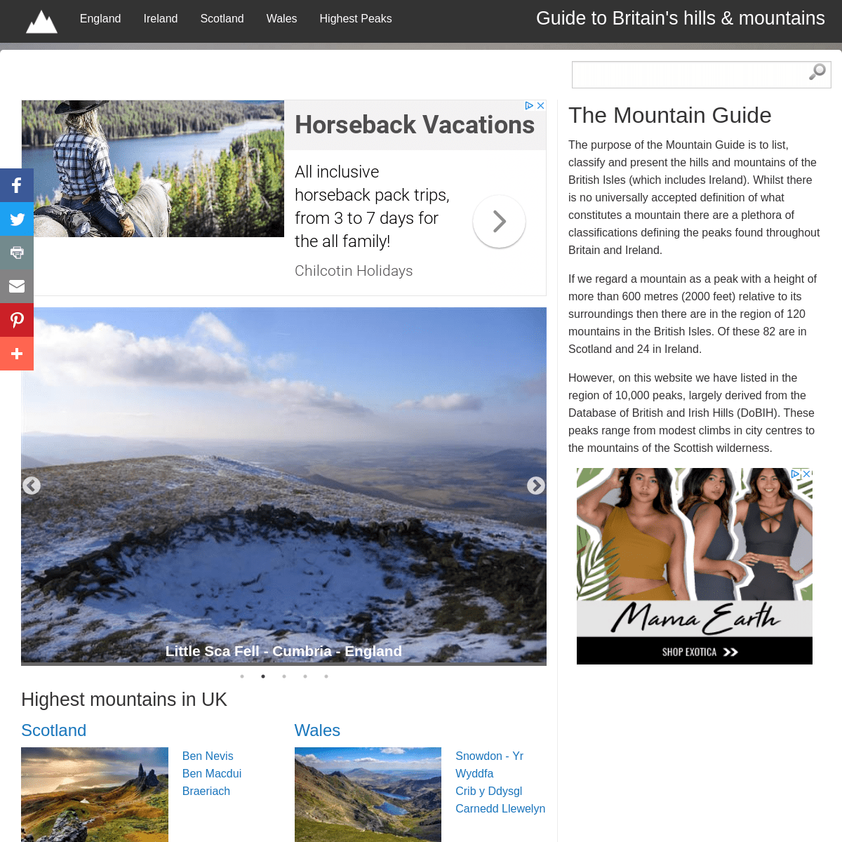
Whins Brow - Lancashire - England Ben Macdui - Aberdeenshire/Moray - Scotland Little Sca Fell - Cumbria - England Coombe Hill - Buckinghamshire - England Crib y Ddysgl - Gwynedd - Wales Whins Brow - Lancashire - England Ben Macdui - Aberdeenshire/Moray - Scotland Little Sca Fell - Cumbria - England Coombe Hill - Buckinghamshire - England Crib y Ddysgl - Gwynedd - Wales Whins Brow - Lancashire - EnglandNext
* 1
* 2
* 3
* 4
* 5
HIGHEST MOUNTAINS IN UK*
SCOTLAND
* Ben Nevis
* Ben Macdui
* Braeriach
*
WALES
* Snowdon - Yr Wyddfa* Crib y Ddysgl
* Carnedd Llewelyn
*
ENGLAND
* Scafell Pike
* Scafell
* Symonds Knott
*
IRELAND
* Carrauntoohil
* Beenkeragh
County Tops
MAJOR MOUNTAIN RANGES OF THE BRITISH ISLES* Cairngorms
* Mourne Mountains
* Black Mountains
* MacGillycuddy's Reeks* Pennines
* Grampians
* Berwyn range
* Snowdonia
* Lake District
* Cheviot Hills (Scotland)* Sperrin Mountains
* Ochil Hills
* Brecon Beacons
* Clwydian Hills
* Glens of Antrim
* Dartmoor
* Moelwinions
THE MOUNTAIN GUIDE
The purpose of the Mountain Guide is to list, classify and present the hills and mountains of the British Isles (which includes Ireland). Whilst there is no universally accepted definition of what constitutes a mountain there are a plethora of classifications defining the peaks found throughout Britain and Ireland. If we regard a mountain as a peak with a height of more than 600 metres (2000 feet) relative to its surroundings then there are in the region of 120 mountains in the British Isles. Of these 82 are in Scotland and 24 in Ireland. However, on this website we have listed in the region of 10,000 peaks, largely derived from the Database of British and Irish Hills (DoBIH). These peaks range from modest climbs in city centres to the mountains of the Scottish wilderness. � The Mountain Guide 2019 AddThis Sharing Sidebar Share to FacebookFacebook , Number of sharesShare to TwitterTwitterShare to PrintPrintShare to EmailEmailShare to PinterestPinterest , Number of sharesMore AddThis Share optionsAddThis, Number of shares
Hide
Show
Close
AddThis
Details
4