6
More Annotations


2


2
Favourite Annotations


1


1
Text
WHAT'S NEW!
Castra Falls and Nietta Creek Tracks have been newly added. 22/9/2013. Higgs Track - new bridge across Dale Brook. 21/9/2013. Stone Hut Track - Bridge across Mother Cummings Rivulet was washed away in 2012 adding a 2km walk/cycle to old track car park. Track information has beenupdated. 21/9/2013.
WEST COAST - TASTRACKS Provides access to the Elliot Range and Lower Franklin River from the Gordon River. Located north of the Elliot Range, grid reference (GDA 94) - Gordon River -42.44304S, 145.67366E and ending at Flat Island Franklin River -42.47236S, 145.76053E. Track starts at a log book on the Gordon River and has tape the whole way to the Flat Island, Franklin River, careful navigation required in two NORTH WEST - TASTRACKS Minnow Falls Track. Located on the eastern side of Mt. Roland. Grid references, Minnow Creek Parking 443640E, 5408200N; Top of Minnow Falls 441560E, 5406940N (AGD66). This steep, rough cut track climbs the eastern side of Mt. Roland climbing 545m in 3.5km. Expect to take3 -
GREAT WESTERN TIERS
Meander Falls Track. A well-defined rough track to Meander Falls, in the Great Western Tiers Conservation Area. It is 4km to the falls. Expect to take 3 hours. Track starts at Meander Falls Picnic Area (-41.7230, 146.5456) and follows southern side of Meander River to the falls (-41.7325, 146.5084). SOUTH WEST - TASTRACKS Located south of the Strathgordon Rd (B61) between Lake Gordon and Lake Pedder, grid references (GDA94) Trackhead Carpark 440500E, 5258100N; Summit Trig 442500E, 5256120N. This w ell used track that is tagged with ribbon and climbs 700m over 7km to the summit of Mt Wedge. Takes about 1.5 to 2 hours to summit. There is a sign at track head car park and a weathered sign about 10 minutes alongMERSEY VALLEY
Moses Creek Track (Cloister Lagoons Track) A Main access track to Chapter Lake, Grail Falls, Cloister Lagoons and Junction Lake from the Mersey Valley. Located between the end of the Mersey Forest Road and Junction Lake, grid reference (AGD 66) - Mersey Forest Road end 431780E, 5366940N; Junction Lake 432200E, 5358550N (Determine usingmap grid).
CRADLE - TASTRACKS
This is an extension of the Overland Track to the north coast at Penguin. Located between Cradle Lodge, Pencil Pine and Penguin and crossing Speeler Plains, traversing the Black Bluff Range, Leven Canyon and Dial Ranges, grid reference (AGD 66) - Pencil Pine 410640E, 5394510N; Penguin Beach (Determine by using 1:25000 Topo Maps).LYELL HIGHWAY
Located between Franklin and Jane Rivers, grid reference (AGD 66) - Lyell Highway 418375E, 5325600N; Jane River End 418200E, 5304500N. Old vehicle track, at times overgrown down to a signal pad through the scrub. Bridges across the large rivers (Franklin, Loddon and Erebus Rivers) are all down. Track is 24km long with a 250m-heightdifference.
PEAK BAGGERS
A comprehensive guide to Tasmanian walking tracks. You can download from here a number of lists of Tasmanian Peaks deemed worthy.CRADLE TRACKS
www.tastracks.webs.com. The intention of this website is to provide information on all the important bush tracks that walkers use to access the more remote parts of Tasmania.WHAT'S NEW!
Castra Falls and Nietta Creek Tracks have been newly added. 22/9/2013. Higgs Track - new bridge across Dale Brook. 21/9/2013. Stone Hut Track - Bridge across Mother Cummings Rivulet was washed away in 2012 adding a 2km walk/cycle to old track car park. Track information has beenupdated. 21/9/2013.
WEST COAST - TASTRACKS Provides access to the Elliot Range and Lower Franklin River from the Gordon River. Located north of the Elliot Range, grid reference (GDA 94) - Gordon River -42.44304S, 145.67366E and ending at Flat Island Franklin River -42.47236S, 145.76053E. Track starts at a log book on the Gordon River and has tape the whole way to the Flat Island, Franklin River, careful navigation required in two NORTH WEST - TASTRACKS Minnow Falls Track. Located on the eastern side of Mt. Roland. Grid references, Minnow Creek Parking 443640E, 5408200N; Top of Minnow Falls 441560E, 5406940N (AGD66). This steep, rough cut track climbs the eastern side of Mt. Roland climbing 545m in 3.5km. Expect to take3 -
GREAT WESTERN TIERS
Meander Falls Track. A well-defined rough track to Meander Falls, in the Great Western Tiers Conservation Area. It is 4km to the falls. Expect to take 3 hours. Track starts at Meander Falls Picnic Area (-41.7230, 146.5456) and follows southern side of Meander River to the falls (-41.7325, 146.5084). SOUTH WEST - TASTRACKS Located south of the Strathgordon Rd (B61) between Lake Gordon and Lake Pedder, grid references (GDA94) Trackhead Carpark 440500E, 5258100N; Summit Trig 442500E, 5256120N. This w ell used track that is tagged with ribbon and climbs 700m over 7km to the summit of Mt Wedge. Takes about 1.5 to 2 hours to summit. There is a sign at track head car park and a weathered sign about 10 minutes alongMERSEY VALLEY
Moses Creek Track (Cloister Lagoons Track) A Main access track to Chapter Lake, Grail Falls, Cloister Lagoons and Junction Lake from the Mersey Valley. Located between the end of the Mersey Forest Road and Junction Lake, grid reference (AGD 66) - Mersey Forest Road end 431780E, 5366940N; Junction Lake 432200E, 5358550N (Determine usingmap grid).
CRADLE - TASTRACKS
This is an extension of the Overland Track to the north coast at Penguin. Located between Cradle Lodge, Pencil Pine and Penguin and crossing Speeler Plains, traversing the Black Bluff Range, Leven Canyon and Dial Ranges, grid reference (AGD 66) - Pencil Pine 410640E, 5394510N; Penguin Beach (Determine by using 1:25000 Topo Maps).LYELL HIGHWAY
Located between Franklin and Jane Rivers, grid reference (AGD 66) - Lyell Highway 418375E, 5325600N; Jane River End 418200E, 5304500N. Old vehicle track, at times overgrown down to a signal pad through the scrub. Bridges across the large rivers (Franklin, Loddon and Erebus Rivers) are all down. Track is 24km long with a 250m-heightdifference.
PEAK BAGGERS
A comprehensive guide to Tasmanian walking tracks. You can download from here a number of lists of Tasmanian Peaks deemed worthy.CRADLE TRACKS
www.tastracks.webs.com. The intention of this website is to provide information on all the important bush tracks that walkers use to access the more remote parts of Tasmania.OTHER TRACKS
This track provides walking access to the south-east corner of Ben Lomond Plateau. Located north of the Rossarden Road. Grid reference: Parking Area 564189E, 5391537N; Ben Lomond Escarpment 562300E, 5393725N AGD66 (Approx). The first 2km is an old logging road and the last 1km is a narrow steep foottrack that is quite overgrown.ABOUT - TASTRACKS
A comprehensive guide to Tasmanian walking tracks. The intention of this website is to provide information on all the important bush tracks that walkers useCONTRIBUTORS
The information on this site is only as good as its contributing bushwalkers. We currently need information on the following tracks. On the Central Plateau we need information for the Lake Antimony and Lake Olive Tracks.Grid references in the new GDA94 system are required for the tracks that are located on the new Lake MacKenzie map sheet.CENTRAL PLATEAU
Provides access from the east into Lake Fanny, Lake Antimony and Great Pine Tier area. Located at the end of the Lake Augusta Road at Lake Ada, grid reference (AGD 66) - Road end; Lake Fanny 448130E, 5365700N. The track is 5km long and climbs 40m. Expect to take 2 hours. A 4km sidetrack heads south to Lake Antimony and the Great Pine Tier.WALKING GUIDE BOOKS
Anon (1974). West Coast Walks. West Coast Outdoor Club. Briggs, M. (1991). Bruny Island: a guide for walkers. Grundy’s Point Press,Tasmania
CRADLE TRACKS
www.tastracks.webs.com. The intention of this website is to provide information on all the important bush tracks that walkers use to access the more remote parts of Tasmania. TRACKS OFF THE LYELL HIGHWAY Described from east to west. www.tastracks.webs.com. The intention of this website is to provide information on all the important bush tracks that walkers use CENTRAL PLATEAU TRACKS www.tastracks.webs.com. The intention of this website is to provide information on all the important bush tracks that walkers use to access the more remote parts of Tasmania.NORTH WEST TRACKS
www.tastracks.webs.com. The intention of this website is to provide information on all the important bush tracks that walkers use to access the more remote parts of Tasmania.WEST COAST TRACKS
Great Western Tiers. www.tastracks.webs.com. The intention of this website is to provide information on all the important bush tracks that walkers use to access the more remote parts of Tasmania.WHAT'S NEW!
Castra Falls and Nietta Creek Tracks have been newly added. 22/9/2013. Higgs Track - new bridge across Dale Brook. 21/9/2013. Stone Hut Track - Bridge across Mother Cummings Rivulet was washed away in 2012 adding a 2km walk/cycle to old track car park. Track information has beenupdated. 21/9/2013.
WEST COAST - TASTRACKS Provides access to the Elliot Range and Lower Franklin River from the Gordon River. Located north of the Elliot Range, grid reference (GDA 94) - Gordon River -42.44304S, 145.67366E and ending at Flat Island Franklin River -42.47236S, 145.76053E. Track starts at a log book on the Gordon River and has tape the whole way to the Flat Island, Franklin River, careful navigation required in two NORTH WEST - TASTRACKS Minnow Falls Track. Located on the eastern side of Mt. Roland. Grid references, Minnow Creek Parking 443640E, 5408200N; Top of Minnow Falls 441560E, 5406940N (AGD66). This steep, rough cut track climbs the eastern side of Mt. Roland climbing 545m in 3.5km. Expect to take3 -
SOUTH EAST - TASTRACKS Lake Skinner Track. Gives access to the southern part of the Snowy Range including Snowy South Peak (1398m). Track begins at forestry coupe, grid reference (AGD 66) - Forestry coupe; Range 473030E, 5245700N. Track is 5km long with a 400m-height gain. There is aGREAT WESTERN TIERS
Meander Falls Track. A well-defined rough track to Meander Falls, in the Great Western Tiers Conservation Area. It is 4km to the falls. Expect to take 3 hours. Track starts at Meander Falls Picnic Area (-41.7230, 146.5456) and follows southern side of Meander River to the falls (-41.7325, 146.5084). SOUTH WEST - TASTRACKS Located south of the Strathgordon Rd (B61) between Lake Gordon and Lake Pedder, grid references (GDA94) Trackhead Carpark 440500E, 5258100N; Summit Trig 442500E, 5256120N. This w ell used track that is tagged with ribbon and climbs 700m over 7km to the summit of Mt Wedge. Takes about 1.5 to 2 hours to summit. There is a sign at track head car park and a weathered sign about 10 minutes alongLYELL HIGHWAY
Located between Franklin and Jane Rivers, grid reference (AGD 66) - Lyell Highway 418375E, 5325600N; Jane River End 418200E, 5304500N. Old vehicle track, at times overgrown down to a signal pad through the scrub. Bridges across the large rivers (Franklin, Loddon and Erebus Rivers) are all down. Track is 24km long with a 250m-heightdifference.
MERSEY VALLEY
Moses Creek Track (Cloister Lagoons Track) A Main access track to Chapter Lake, Grail Falls, Cloister Lagoons and Junction Lake from the Mersey Valley. Located between the end of the Mersey Forest Road and Junction Lake, grid reference (AGD 66) - Mersey Forest Road end 431780E, 5366940N; Junction Lake 432200E, 5358550N (Determine usingmap grid).
CRADLE - TASTRACKS
This is an extension of the Overland Track to the north coast at Penguin. Located between Cradle Lodge, Pencil Pine and Penguin and crossing Speeler Plains, traversing the Black Bluff Range, Leven Canyon and Dial Ranges, grid reference (AGD 66) - Pencil Pine 410640E, 5394510N; Penguin Beach (Determine by using 1:25000 Topo Maps).PEAK BAGGERS
A comprehensive guide to Tasmanian walking tracks. You can download from here a number of lists of Tasmanian Peaks deemed worthy.WHAT'S NEW!
Castra Falls and Nietta Creek Tracks have been newly added. 22/9/2013. Higgs Track - new bridge across Dale Brook. 21/9/2013. Stone Hut Track - Bridge across Mother Cummings Rivulet was washed away in 2012 adding a 2km walk/cycle to old track car park. Track information has beenupdated. 21/9/2013.
WEST COAST - TASTRACKS Provides access to the Elliot Range and Lower Franklin River from the Gordon River. Located north of the Elliot Range, grid reference (GDA 94) - Gordon River -42.44304S, 145.67366E and ending at Flat Island Franklin River -42.47236S, 145.76053E. Track starts at a log book on the Gordon River and has tape the whole way to the Flat Island, Franklin River, careful navigation required in two NORTH WEST - TASTRACKS Minnow Falls Track. Located on the eastern side of Mt. Roland. Grid references, Minnow Creek Parking 443640E, 5408200N; Top of Minnow Falls 441560E, 5406940N (AGD66). This steep, rough cut track climbs the eastern side of Mt. Roland climbing 545m in 3.5km. Expect to take3 -
SOUTH EAST - TASTRACKS Lake Skinner Track. Gives access to the southern part of the Snowy Range including Snowy South Peak (1398m). Track begins at forestry coupe, grid reference (AGD 66) - Forestry coupe; Range 473030E, 5245700N. Track is 5km long with a 400m-height gain. There is aGREAT WESTERN TIERS
Meander Falls Track. A well-defined rough track to Meander Falls, in the Great Western Tiers Conservation Area. It is 4km to the falls. Expect to take 3 hours. Track starts at Meander Falls Picnic Area (-41.7230, 146.5456) and follows southern side of Meander River to the falls (-41.7325, 146.5084). SOUTH WEST - TASTRACKS Located south of the Strathgordon Rd (B61) between Lake Gordon and Lake Pedder, grid references (GDA94) Trackhead Carpark 440500E, 5258100N; Summit Trig 442500E, 5256120N. This w ell used track that is tagged with ribbon and climbs 700m over 7km to the summit of Mt Wedge. Takes about 1.5 to 2 hours to summit. There is a sign at track head car park and a weathered sign about 10 minutes alongLYELL HIGHWAY
Located between Franklin and Jane Rivers, grid reference (AGD 66) - Lyell Highway 418375E, 5325600N; Jane River End 418200E, 5304500N. Old vehicle track, at times overgrown down to a signal pad through the scrub. Bridges across the large rivers (Franklin, Loddon and Erebus Rivers) are all down. Track is 24km long with a 250m-heightdifference.
MERSEY VALLEY
Moses Creek Track (Cloister Lagoons Track) A Main access track to Chapter Lake, Grail Falls, Cloister Lagoons and Junction Lake from the Mersey Valley. Located between the end of the Mersey Forest Road and Junction Lake, grid reference (AGD 66) - Mersey Forest Road end 431780E, 5366940N; Junction Lake 432200E, 5358550N (Determine usingmap grid).
CRADLE - TASTRACKS
This is an extension of the Overland Track to the north coast at Penguin. Located between Cradle Lodge, Pencil Pine and Penguin and crossing Speeler Plains, traversing the Black Bluff Range, Leven Canyon and Dial Ranges, grid reference (AGD 66) - Pencil Pine 410640E, 5394510N; Penguin Beach (Determine by using 1:25000 Topo Maps).PEAK BAGGERS
A comprehensive guide to Tasmanian walking tracks. You can download from here a number of lists of Tasmanian Peaks deemed worthy.OTHER TRACKS
This track provides walking access to the south-east corner of Ben Lomond Plateau. Located north of the Rossarden Road. Grid reference: Parking Area 564189E, 5391537N; Ben Lomond Escarpment 562300E, 5393725N AGD66 (Approx). The first 2km is an old logging road and the last 1km is a narrow steep foottrack that is quite overgrown.ABOUT - TASTRACKS
A comprehensive guide to Tasmanian walking tracks. The intention of this website is to provide information on all the important bush tracks that walkers useCONTRIBUTORS
The information on this site is only as good as its contributing bushwalkers. We currently need information on the following tracks. On the Central Plateau we need information for the Lake Antimony and Lake Olive Tracks.Grid references in the new GDA94 system are required for the tracks that are located on the new Lake MacKenzie map sheet.CENTRAL PLATEAU
Provides access from the east into Lake Fanny, Lake Antimony and Great Pine Tier area. Located at the end of the Lake Augusta Road at Lake Ada, grid reference (AGD 66) - Road end; Lake Fanny 448130E, 5365700N. The track is 5km long and climbs 40m. Expect to take 2 hours. A 4km sidetrack heads south to Lake Antimony and the Great Pine Tier.WALKING GUIDE BOOKS
Anon (1974). West Coast Walks. West Coast Outdoor Club. Briggs, M. (1991). Bruny Island: a guide for walkers. Grundy’s Point Press,Tasmania
CRADLE TRACKS
www.tastracks.webs.com. The intention of this website is to provide information on all the important bush tracks that walkers use to access the more remote parts of Tasmania. TRACKS OFF THE LYELL HIGHWAY Described from east to west. www.tastracks.webs.com. The intention of this website is to provide information on all the important bush tracks that walkers use PEAK 1:100 000 1:25 000 REF. HEIGHT ABBOTTS LO TYENNA Sheet1 Page 1 Peak 1:100 000 1:25 000 Ref. Height Abbotts LO Tyenna Maydena 716633 1106 Achilles Sophia Achilles 150652 1363 Acropolis Mersey Du Cane 220568 1480NORTH WEST TRACKS
www.tastracks.webs.com. The intention of this website is to provide information on all the important bush tracks that walkers use to access the more remote parts of Tasmania. SOUTH WEST - WEBSWEB VIEW www.tastracks.webs.com. The intention of this website is to provide information on all the important bush tracks that walkers use to access the more remote parts of Tasmania.WHAT'S NEW!
Castra Falls and Nietta Creek Tracks have been newly added. 22/9/2013. Higgs Track - new bridge across Dale Brook. 21/9/2013. Stone Hut Track - Bridge across Mother Cummings Rivulet was washed away in 2012 adding a 2km walk/cycle to old track car park. Track information has beenupdated. 21/9/2013.
WEST COAST - TASTRACKS Provides access to the Elliot Range and Lower Franklin River from the Gordon River. Located north of the Elliot Range, grid reference (GDA 94) - Gordon River -42.44304S, 145.67366E and ending at Flat Island Franklin River -42.47236S, 145.76053E. Track starts at a log book on the Gordon River and has tape the whole way to the Flat Island, Franklin River, careful navigation required in two NORTH WEST - TASTRACKS Minnow Falls Track. Located on the eastern side of Mt. Roland. Grid references, Minnow Creek Parking 443640E, 5408200N; Top of Minnow Falls 441560E, 5406940N (AGD66). This steep, rough cut track climbs the eastern side of Mt. Roland climbing 545m in 3.5km. Expect to take3 -
SOUTH EAST - TASTRACKS Lake Skinner Track. Gives access to the southern part of the Snowy Range including Snowy South Peak (1398m). Track begins at forestry coupe, grid reference (AGD 66) - Forestry coupe; Range 473030E, 5245700N. Track is 5km long with a 400m-height gain. There is aGREAT WESTERN TIERS
Meander Falls Track. A well-defined rough track to Meander Falls, in the Great Western Tiers Conservation Area. It is 4km to the falls. Expect to take 3 hours. Track starts at Meander Falls Picnic Area (-41.7230, 146.5456) and follows southern side of Meander River to the falls (-41.7325, 146.5084). SOUTH WEST - TASTRACKS Located south of the Strathgordon Rd (B61) between Lake Gordon and Lake Pedder, grid references (GDA94) Trackhead Carpark 440500E, 5258100N; Summit Trig 442500E, 5256120N. This w ell used track that is tagged with ribbon and climbs 700m over 7km to the summit of Mt Wedge. Takes about 1.5 to 2 hours to summit. There is a sign at track head car park and a weathered sign about 10 minutes alongLYELL HIGHWAY
Located between Franklin and Jane Rivers, grid reference (AGD 66) - Lyell Highway 418375E, 5325600N; Jane River End 418200E, 5304500N. Old vehicle track, at times overgrown down to a signal pad through the scrub. Bridges across the large rivers (Franklin, Loddon and Erebus Rivers) are all down. Track is 24km long with a 250m-heightdifference.
MERSEY VALLEY
Moses Creek Track (Cloister Lagoons Track) A Main access track to Chapter Lake, Grail Falls, Cloister Lagoons and Junction Lake from the Mersey Valley. Located between the end of the Mersey Forest Road and Junction Lake, grid reference (AGD 66) - Mersey Forest Road end 431780E, 5366940N; Junction Lake 432200E, 5358550N (Determine usingmap grid).
CRADLE - TASTRACKS
This is an extension of the Overland Track to the north coast at Penguin. Located between Cradle Lodge, Pencil Pine and Penguin and crossing Speeler Plains, traversing the Black Bluff Range, Leven Canyon and Dial Ranges, grid reference (AGD 66) - Pencil Pine 410640E, 5394510N; Penguin Beach (Determine by using 1:25000 Topo Maps).PEAK BAGGERS
A comprehensive guide to Tasmanian walking tracks. You can download from here a number of lists of Tasmanian Peaks deemed worthy.WHAT'S NEW!
Castra Falls and Nietta Creek Tracks have been newly added. 22/9/2013. Higgs Track - new bridge across Dale Brook. 21/9/2013. Stone Hut Track - Bridge across Mother Cummings Rivulet was washed away in 2012 adding a 2km walk/cycle to old track car park. Track information has beenupdated. 21/9/2013.
WEST COAST - TASTRACKS Provides access to the Elliot Range and Lower Franklin River from the Gordon River. Located north of the Elliot Range, grid reference (GDA 94) - Gordon River -42.44304S, 145.67366E and ending at Flat Island Franklin River -42.47236S, 145.76053E. Track starts at a log book on the Gordon River and has tape the whole way to the Flat Island, Franklin River, careful navigation required in two NORTH WEST - TASTRACKS Minnow Falls Track. Located on the eastern side of Mt. Roland. Grid references, Minnow Creek Parking 443640E, 5408200N; Top of Minnow Falls 441560E, 5406940N (AGD66). This steep, rough cut track climbs the eastern side of Mt. Roland climbing 545m in 3.5km. Expect to take3 -
SOUTH EAST - TASTRACKS Lake Skinner Track. Gives access to the southern part of the Snowy Range including Snowy South Peak (1398m). Track begins at forestry coupe, grid reference (AGD 66) - Forestry coupe; Range 473030E, 5245700N. Track is 5km long with a 400m-height gain. There is aGREAT WESTERN TIERS
Meander Falls Track. A well-defined rough track to Meander Falls, in the Great Western Tiers Conservation Area. It is 4km to the falls. Expect to take 3 hours. Track starts at Meander Falls Picnic Area (-41.7230, 146.5456) and follows southern side of Meander River to the falls (-41.7325, 146.5084). SOUTH WEST - TASTRACKS Located south of the Strathgordon Rd (B61) between Lake Gordon and Lake Pedder, grid references (GDA94) Trackhead Carpark 440500E, 5258100N; Summit Trig 442500E, 5256120N. This w ell used track that is tagged with ribbon and climbs 700m over 7km to the summit of Mt Wedge. Takes about 1.5 to 2 hours to summit. There is a sign at track head car park and a weathered sign about 10 minutes alongLYELL HIGHWAY
Located between Franklin and Jane Rivers, grid reference (AGD 66) - Lyell Highway 418375E, 5325600N; Jane River End 418200E, 5304500N. Old vehicle track, at times overgrown down to a signal pad through the scrub. Bridges across the large rivers (Franklin, Loddon and Erebus Rivers) are all down. Track is 24km long with a 250m-heightdifference.
MERSEY VALLEY
Moses Creek Track (Cloister Lagoons Track) A Main access track to Chapter Lake, Grail Falls, Cloister Lagoons and Junction Lake from the Mersey Valley. Located between the end of the Mersey Forest Road and Junction Lake, grid reference (AGD 66) - Mersey Forest Road end 431780E, 5366940N; Junction Lake 432200E, 5358550N (Determine usingmap grid).
CRADLE - TASTRACKS
This is an extension of the Overland Track to the north coast at Penguin. Located between Cradle Lodge, Pencil Pine and Penguin and crossing Speeler Plains, traversing the Black Bluff Range, Leven Canyon and Dial Ranges, grid reference (AGD 66) - Pencil Pine 410640E, 5394510N; Penguin Beach (Determine by using 1:25000 Topo Maps).PEAK BAGGERS
A comprehensive guide to Tasmanian walking tracks. You can download from here a number of lists of Tasmanian Peaks deemed worthy.OTHER TRACKS
This track provides walking access to the south-east corner of Ben Lomond Plateau. Located north of the Rossarden Road. Grid reference: Parking Area 564189E, 5391537N; Ben Lomond Escarpment 562300E, 5393725N AGD66 (Approx). The first 2km is an old logging road and the last 1km is a narrow steep foottrack that is quite overgrown.ABOUT - TASTRACKS
A comprehensive guide to Tasmanian walking tracks. The intention of this website is to provide information on all the important bush tracks that walkers useCONTRIBUTORS
The information on this site is only as good as its contributing bushwalkers. We currently need information on the following tracks. On the Central Plateau we need information for the Lake Antimony and Lake Olive Tracks.Grid references in the new GDA94 system are required for the tracks that are located on the new Lake MacKenzie map sheet.CENTRAL PLATEAU
Provides access from the east into Lake Fanny, Lake Antimony and Great Pine Tier area. Located at the end of the Lake Augusta Road at Lake Ada, grid reference (AGD 66) - Road end; Lake Fanny 448130E, 5365700N. The track is 5km long and climbs 40m. Expect to take 2 hours. A 4km sidetrack heads south to Lake Antimony and the Great Pine Tier.WALKING GUIDE BOOKS
Anon (1974). West Coast Walks. West Coast Outdoor Club. Briggs, M. (1991). Bruny Island: a guide for walkers. Grundy’s Point Press,Tasmania
CRADLE TRACKS
www.tastracks.webs.com. The intention of this website is to provide information on all the important bush tracks that walkers use to access the more remote parts of Tasmania. TRACKS OFF THE LYELL HIGHWAY Described from east to west. www.tastracks.webs.com. The intention of this website is to provide information on all the important bush tracks that walkers use PEAK 1:100 000 1:25 000 REF. HEIGHT ABBOTTS LO TYENNA Sheet1 Page 1 Peak 1:100 000 1:25 000 Ref. Height Abbotts LO Tyenna Maydena 716633 1106 Achilles Sophia Achilles 150652 1363 Acropolis Mersey Du Cane 220568 1480NORTH WEST TRACKS
www.tastracks.webs.com. The intention of this website is to provide information on all the important bush tracks that walkers use to access the more remote parts of Tasmania. SOUTH WEST - WEBSWEB VIEW www.tastracks.webs.com. The intention of this website is to provide information on all the important bush tracks that walkers use to access the more remote parts of Tasmania.TASTRACKS
A COMPREHENSIVE GUIDE TO TASMANIAN WALKING TRACKS.* What's New!
* About
* Central Plateau
* Cradle
* Great Western Tiers* Lyell Highway
* Mersey Valley
* North West
* South East
* South West
* West Coast
* Other Tracks
* Walking guide books* Peak Baggers
* Contributors
* Forums
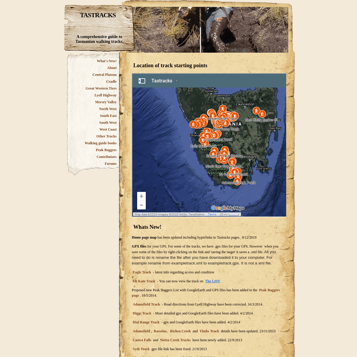
LOCATION OF TRACK STARTING POINTSWHATS NEW!
HOME PAGE MAP has been updated including hyperlinks to Tastrackspages. 8/12/2019
GPX FILES for your GPS. For some of the tracks, we have .gpx files for your GPS. However when you save some of the files by right-clicking on the link and 'saving the target' it saves a .xml file. All you need to do is rename the file after you have downloaded it to your computer. For example rename from exampletrack.xml to exampletrack.gpx. It is not a xml file.EAGLE TRACK
- latest info
regarding access and condition MT KATE TRACK - You can now view the track on The LIST Proposed new Peak Baggers List with GoogleEarth and GPS files has been added to the Peak Baggers page. 18/5/2014.
Adamsfield Track -
Road directions from Lyell Highway have been corrected. 16/3/2014.Higgs Track
- More
detailed gpx and GoogleEarth files have been added. 4/2/2014Dial Range Track
- gpx and
GoogleEarth files have been added. 4/2/2014Adamsfield ,
Rasselas, Richea
Creek and Timbs
Track details have
been updated. 23/11/2013Castra Falls and
Nietta Creek Tracks
have been newly
added. 22/9/2013
Syds Track
gpx file link has been fixed. 21/9/2013Higgs Track
- new
bridge across Dale Brook. 21/9/2013Stone Hut Track
- Bridge
across Mother Cummings Rivulet was washed away in 2012 adding a 2km walk/cycle to old track car park. Track information has been updated.21/9/2013.
Bastion Cascades / Croft Tracks- Bridge
across Mother Cummings Rivulet was washed away in 2012 adding a 2 km walk/cycle to old track car park. Track information has been updated.21/9/2013.
Mt Housetop Track
info update. 29/7/2013 Mt.Duncan Track info updated with links to Google maps, GoogleEarth and a downloadable gpx file.15/6/2013
GoogleEarth map (.kml) and GPS track file (.gpx) has been added for Moses Creek Track (Cloister Lagoons Track) in the Mersey Valley.6/5/2013
GoogleEarth map (.kml) and GPS track file (.gpx) has been added for Western Bluff Track in the Great Western Tiers. 13/4/2013 GoogleEarth Map (.kml) and GPS track file (.gpx) of the new Dick Smith funded track (Pickaxe Ridge Track) across the Sodden Loddons has been added for Frenchmans Cap Track on the Lyell Highway page. 13/4/2013 Updates for Kermandie Track between Geeveeston and Hartz Range (South East) and Mt Jubilee Range Route in the Styx Valley (South West) have been added. 12/1/2013 A new peak baggers list (Tasmanian Mountains Connoisseurs List by Bowling, Doran and Geeves 2012 is available for download from the Peak Baggers page. 28/10/2012 A rough bridge has been constructed over Dale Brook at the start of the Higgs Track in the Great Western Tiers to replace the crossing washed away last year. See Higgs Track entry on Great Western Tierspage. 28/10/2012
Information for the Mt Sprent Track has been added to the South West page, include track profiles and a .gpx file for your GPS. 28/10/2012 Links to external track descriptions on Cradle page have been updated.16/9/2012
Ironstone, Dell, Stone Hut, Bastions Cascades, Split Rock, Meander Falls and Dixons Tracks in the Great Western Tiers have been updated, including GoogleEarth and gpx flie links. Also a GoogleEarth/gpx. track of the Temporary Access Road to Meander Falls Picnic Area has been added. 17/6/2012 Bent Bluff Track, GoogleEarth/Maps files and .gpx files for your GPS have been added.15/05/2012 GoogleEarth/Maps files and .gpx files for your GPS have been added for Warners Track in the Great Western Tiers. 26/4/2012 GoogleEarth/Maps files and .gpx files for your GPS have been added for Staggs Track and Johnstones Track in the Western Tiers. 25/4/2012 Ragged Jack Track that accesses the western peak has been added to the 'Other Tracks Page ', including GoogleEarth/Maps kml files and gpx files for your GPS.5/2/2012
GPX Tracks for your GPS and KMZ Google map files have been added to the Higgs Track and Syds Track descriptions. Merry Christmas.23/12/2011
Jubilee Range Route has been added to the South West Page and Mt Riveaux Route to the South East page. 23/12/2011 Mt Kate Logging Track and Little Horn Track have been added to the Cradle page. 18/12/2011 A forum page has been added to allow discussion and direct contributions. 8/12/2011 GPX files for Lake Fanny Track on the Central Plateau and Mother Cumnings (Southern) Track in the Great Western Tiers have been added. GPX files can be imported into your GPS or opened in Google Earth.8/12/2011
A new peakbaggers list has been added to the Peak Baggers page. Tasmanian High Places V2 features GPS checked mountain heights, links to Google maps and additional peaks currently not on any other list. Excel Spreadsheet created by M Doran. 15/11/2011 GPS Tracks (.gpx) and photos have been added to Adamsfield, Bombardier, Rassellas and Timbs Tracks. 15/11/2011 Details for the Bommardier Track in the South West has been updated.10/11/2011
Liffey Bluff Track has been added to the Great Western Tiers page including a .gpx file for your GPS or mapping software. 2/11/2011 Link to Bill Shepherd website on Wilmot River Walks and Minnow Falls Track has been updated, see North West Page. 25/10/2011 GPS Waypoint transfer files: The first .gpx file has been loaded onto the site. It can be accessed within the Wylds Craig Track description section. The file contains waypoints along the track and can be imported into many different GPS units as well as some GIS software and Google Earth. Try it out. Contribute a gpx file of on of the tracks on this site. 20/10/2011 Wylds Craig Track has been added to the South West Page aswell as Rassalas and Mt Wedge Track information having been updated.20/10/2011
Got something new to report, send it in via email totastrack@gmail.com
Details
6