5
More Annotations


6


4
Favourite Annotations


6


1
Text
PATH FOUNDATIONABOUTTRAILSNEWSCONTACTOUR MISSIONPATH BOARD How We Entered This PATH. Since 1991, the PATH Foundation has been transforming the landscape of the greater metropolitan Atlanta area. By skillfully combining philanthropic, public and other funding sources, PATH has turned abandoned railroad corridors into beautiful linear green spaces, linked neighborhoods to bustling commercial centers and provided alternative modes of transportation for OUR TRAILS — PATH FOUNDATION WELCOME TO THE PATH TRAIL MAPS! PATH has over 300 miles of trails throughout Georgia and beyond. Each trail page contains a description, an interactive map and a printable map that details the trail as well as the surrounding areas and points of interest. Enjoy these easy to navigate maps for your next trail experience! DONORS — PATH FOUNDATION Our Donors. PATH's MILE 300 Capital Campaign will secure $18.5 million in philanthropic investments. Every charitable dollar raised in this campaign will be matched with more than four dollars of state, local, and project-specific funding, allowing PATH to build more than $100 million in new trail projects. ARABIA MOUNTAIN PATH About: The Arabia Mountain PATH serpentines through wooded valleys lined with wildflowers and incredible granite outcroppings while connecting Lithonia, Stonecrest Mall, the Arabia Mountain Nature Center to Panola Mountain State Park.It is a bit hilly so bring your energy bar along. The trail visits the historic ruins of the granite quarry in mile 4 before crossing several creeks and a large
TRAIL MAINTENANCE
The PATH trails are maintained by the local Departments of Parks and Recreation in the city or county that the trail passes through. If you come across an area on a trail that needs to have brush cut back, downed trees removed, damaged signs, bridges or handrails repaired or excess garbage accumulation, locate the appropriate resource below andlet them know.
SOUTH PEACHTREE CREEK TRAIL Distance: 3.6 Miles. About: This trail features a mile of boardwalk through a forest and over a wetland with seating areas to watch the wildlife or frequent trains on the nearby track. The trail connects Medlock Park to Mason Mill Park and Emory University. The kids will love the bridge over the railroad. There is a labyrinth ofsoft-surfaced
TRAIL DESCRIPTIONS AND MAPS Trail Descriptions and Maps. PATH trails enhance community spirit and bring neighborhoods together. Each day, thousands of joggers, walkers, bikers and skaters from all walks of life escape the roads and hit the trails for travel and recreation. The demand for trails has increased dramatically as our citizens look for safer ways to exercise OLDE TOWN CONYERS TRAIL Olde Town Conyers Trail. PATH has partnered with the City of Conyers and the Rockdale Board of education to build a trail from downtown Conyers through Wheeler Park and the Rockdale Career Academy to Johnson Park. Future segments will go north and east to Pine Log Park.Interactive Map.
SILVER COMET
PATH also agreed to coordinate development and oversee construction of the trail, except in Cobb County, where the Cobb County DOT built the trail. The Silver Comet is now complete to the Georgia/Alabama state line, and the Chief Ladiga Trail runs from the state line to Anniston, Alabama, providing a 95.5-mile-long continuous trail from AtlantaSOUTHTOWNE TRAIL
The Southtowne Trail connects the Brown’s Mill Recreation Center on Cleveland Ave to Southbend Park on Lakewood Ave. It traverses the Swan Nature Preserve with a spectacular bridge over a tributary to the South River. A trailhead with parking is located on McWilliams PATH FOUNDATIONABOUTTRAILSNEWSCONTACTOUR MISSIONPATH BOARD How We Entered This PATH. Since 1991, the PATH Foundation has been transforming the landscape of the greater metropolitan Atlanta area. By skillfully combining philanthropic, public and other funding sources, PATH has turned abandoned railroad corridors into beautiful linear green spaces, linked neighborhoods to bustling commercial centers and provided alternative modes of transportation for OUR TRAILS — PATH FOUNDATION WELCOME TO THE PATH TRAIL MAPS! PATH has over 300 miles of trails throughout Georgia and beyond. Each trail page contains a description, an interactive map and a printable map that details the trail as well as the surrounding areas and points of interest. Enjoy these easy to navigate maps for your next trail experience! DONORS — PATH FOUNDATION Our Donors. PATH's MILE 300 Capital Campaign will secure $18.5 million in philanthropic investments. Every charitable dollar raised in this campaign will be matched with more than four dollars of state, local, and project-specific funding, allowing PATH to build more than $100 million in new trail projects. ARABIA MOUNTAIN PATH About: The Arabia Mountain PATH serpentines through wooded valleys lined with wildflowers and incredible granite outcroppings while connecting Lithonia, Stonecrest Mall, the Arabia Mountain Nature Center to Panola Mountain State Park.It is a bit hilly so bring your energy bar along. The trail visits the historic ruins of the granite quarry in mile 4 before crossing several creeks and a largeTRAIL MAINTENANCE
The PATH trails are maintained by the local Departments of Parks and Recreation in the city or county that the trail passes through. If you come across an area on a trail that needs to have brush cut back, downed trees removed, damaged signs, bridges or handrails repaired or excess garbage accumulation, locate the appropriate resource below andlet them know.
SOUTH PEACHTREE CREEK TRAIL Distance: 3.6 Miles. About: This trail features a mile of boardwalk through a forest and over a wetland with seating areas to watch the wildlife or frequent trains on the nearby track. The trail connects Medlock Park to Mason Mill Park and Emory University. The kids will love the bridge over the railroad. There is a labyrinth ofsoft-surfaced
TRAIL DESCRIPTIONS AND MAPS Trail Descriptions and Maps. PATH trails enhance community spirit and bring neighborhoods together. Each day, thousands of joggers, walkers, bikers and skaters from all walks of life escape the roads and hit the trails for travel and recreation. The demand for trails has increased dramatically as our citizens look for safer ways to exercise OLDE TOWN CONYERS TRAIL Olde Town Conyers Trail. PATH has partnered with the City of Conyers and the Rockdale Board of education to build a trail from downtown Conyers through Wheeler Park and the Rockdale Career Academy to Johnson Park. Future segments will go north and east to Pine Log Park.Interactive Map.
SILVER COMET
PATH also agreed to coordinate development and oversee construction of the trail, except in Cobb County, where the Cobb County DOT built the trail. The Silver Comet is now complete to the Georgia/Alabama state line, and the Chief Ladiga Trail runs from the state line to Anniston, Alabama, providing a 95.5-mile-long continuous trail from AtlantaSOUTHTOWNE TRAIL
The Southtowne Trail connects the Brown’s Mill Recreation Center on Cleveland Ave to Southbend Park on Lakewood Ave. It traverses the Swan Nature Preserve with a spectacular bridge over a tributary to the South River. A trailhead with parking is located on McWilliams DONORS — PATH FOUNDATION Our Donors. PATH's MILE 300 Capital Campaign will secure $18.5 million in philanthropic investments. Every charitable dollar raised in this campaign will be matched with more than four dollars of state, local, and project-specific funding, allowing PATH to build more than $100 million in new trail projects.ANNOUNCEMENTS
PATH in the Press. Beth Marks 5/26/21 Beth Marks 5/26/21. PATH Announces the 30 Year Anniversary Challenge AND NEW Trail Maps. Read More. Beth Marks 3/24/21 Beth Marks 3/24/21. Westside BeltLine Connector is Open! Read More. Beth Marks 2/19/21 Beth Marks 2/19/21. New Trail Opening in Henry County Georgia- Panola Mountain Greenway. FINANCIALS — PATH FOUNDATION Annual Reports. As a non-profit organization dependent upon donations, gifts, and support from multiple resources, the PATH Foundation is committed to maintaining a clear record of financial statements and documents. Transparency and integrity are part of our commitment to the community and our generous benefactors. The PATH Foundation isTRAIL MAINTENANCE
The PATH trails are maintained by the local Departments of Parks and Recreation in the city or county that the trail passes through. If you come across an area on a trail that needs to have brush cut back, downed trees removed, damaged signs, bridges or handrails repaired or excess garbage accumulation, locate the appropriate resource below andlet them know.
PATH BOARD — PATH FOUNDATION Sam Bacote. Brian Cosgray. W. Douglas Ellis, Jr. Bill Fowler. Sam Friedman. B. Harvey Hill, Jr. Ciannat Howett SOUTH PEACHTREE CREEK TRAIL Distance: 3.6 Miles. About: This trail features a mile of boardwalk through a forest and over a wetland with seating areas to watch the wildlife or frequent trains on the nearby track. The trail connects Medlock Park to Mason Mill Park and Emory University. The kids will love the bridge over the railroad. There is a labyrinth ofsoft-surfaced
TRAIL DESCRIPTIONS AND MAPS Trail Descriptions and Maps. PATH trails enhance community spirit and bring neighborhoods together. Each day, thousands of joggers, walkers, bikers and skaters from all walks of life escape the roads and hit the trails for travel and recreation. The demand for trails has increased dramatically as our citizens look for safer ways to exerciseSOUTH RIVER TRAIL
South River Trail - Shoal Creek Bridge. Construction. Nov 5. Written By Beth Marks. YouTube. PATH Foundation. 68 subscribers. Subscribe. PATH South River Trail - Shoal Creek Bridge. NEWNAN LINC GETS A NEW BRIDGE Newnan LINC Gets a New Bridge. A 278 foot pedestrian bridge will be set over I-85 the weekend of October 17-18, 2020 as part of the newest phase of the Newnan LINC Trail System. Congratulations to the City of Newnan and Friends of the LINC for what will be a huge accomplishment in connecting the east and west sides by way of the LINC. MAPS.PATHFOUNDATION.ORG maps.pathfoundation.org PATH FOUNDATIONABOUTTRAILSNEWSCONTACTOUR MISSIONPATH BOARD How We Entered This PATH. Since 1991, the PATH Foundation has been transforming the landscape of the greater metropolitan Atlanta area. By skillfully combining philanthropic, public and other funding sources, PATH has turned abandoned railroad corridors into beautiful linear green spaces, linked neighborhoods to bustling commercial centers and provided alternative modes of transportation for OUR TRAILS — PATH FOUNDATION WELCOME TO THE PATH TRAIL MAPS! PATH has over 300 miles of trails throughout Georgia and beyond. Each trail page contains a description, an interactive map and a printable map that details the trail as well as the surrounding areas and points of interest. Enjoy these easy to navigate maps for your next trail experience!PATH TRAILS
PATH Trails. Below you’ll find the Atlanta Regional PATH Trails. Scroll down below the map to view our trails outside of this area. STAFF — PATH FOUNDATION Pete Pellegrini Project Manager. Suzanne Scully Executive Assistant. PATH Foundation PO Box 14327 Atlanta, Georgia 30324 OLDE TOWN CONYERS TRAIL Olde Town Conyers Trail. PATH has partnered with the City of Conyers and the Rockdale Board of education to build a trail from downtown Conyers through Wheeler Park and the Rockdale Career Academy to Johnson Park. Future segments will go north and east to Pine Log Park.Interactive Map.
PROCTOR CREEK PATH
Proctor Creek Greenway will eventually stretch from the BeltLine to the Chattahoochee River. The multi-purpose trail will string together more than 400 acres of greenspace, spanning from Maddox Park along the Beltline Westside Trail all the way to the Chattahoochee River. Concept prepared by KAIZEN Collaborative for the PATH Foundation.YouTube.
SOUTH RIVER TRAIL
It features a trail head near Bouldercrest Road and Constitution, a tunnel under Bouldercrest Road, scenic overlooks of the South River, a bridge over Sugar Creek, and spur trails to surrounding neighborhoods. PATH recently completed the 3.4 mile extension of the trail along the periphery of the golf course, under I-285, and onto the campus ofSILVER COMET
PATH also agreed to coordinate development and oversee construction of the trail, except in Cobb County, where the Cobb County DOT built the trail. The Silver Comet is now complete to the Georgia/Alabama state line, and the Chief Ladiga Trail runs from the state line to Anniston, Alabama, providing a 95.5-mile-long continuous trail from AtlantaLAGRANGE THREAD MAP
LaGrange Thread Map. The City of LaGrange and the Friends of the Thread officially opened the first segment of the LaGrange Thread on July 22nd. The 1.8 mile-long trail originates two blocks from Lafayette Square and weaves through Granger Park near LaGrange High School. The steering committee chose “The Thread” as the name forthe trail
SOUTH PEACHTREE CREEK TRAIL The South Peachtree Creek Trail meanders through Mason Mill Park as a boardwalk along the banks of the creek. It connects the ball fields and parking area at Medlock Park to the historic Decatur Waterworks and the Tennis Center at Mason Mill Park. DeKalb County and PATH have developed two phases of the South Peachtree Creek Trail which connects PATH FOUNDATIONABOUTTRAILSNEWSCONTACTOUR MISSIONPATH BOARD How We Entered This PATH. Since 1991, the PATH Foundation has been transforming the landscape of the greater metropolitan Atlanta area. By skillfully combining philanthropic, public and other funding sources, PATH has turned abandoned railroad corridors into beautiful linear green spaces, linked neighborhoods to bustling commercial centers and provided alternative modes of transportation for OUR TRAILS — PATH FOUNDATION WELCOME TO THE PATH TRAIL MAPS! PATH has over 300 miles of trails throughout Georgia and beyond. Each trail page contains a description, an interactive map and a printable map that details the trail as well as the surrounding areas and points of interest. Enjoy these easy to navigate maps for your next trail experience!PATH TRAILS
PATH Trails. Below you’ll find the Atlanta Regional PATH Trails. Scroll down below the map to view our trails outside of this area. STAFF — PATH FOUNDATION Pete Pellegrini Project Manager. Suzanne Scully Executive Assistant. PATH Foundation PO Box 14327 Atlanta, Georgia 30324 OLDE TOWN CONYERS TRAIL Olde Town Conyers Trail. PATH has partnered with the City of Conyers and the Rockdale Board of education to build a trail from downtown Conyers through Wheeler Park and the Rockdale Career Academy to Johnson Park. Future segments will go north and east to Pine Log Park.Interactive Map.
PROCTOR CREEK PATH
Proctor Creek Greenway will eventually stretch from the BeltLine to the Chattahoochee River. The multi-purpose trail will string together more than 400 acres of greenspace, spanning from Maddox Park along the Beltline Westside Trail all the way to the Chattahoochee River. Concept prepared by KAIZEN Collaborative for the PATH Foundation.YouTube.
SOUTH RIVER TRAIL
It features a trail head near Bouldercrest Road and Constitution, a tunnel under Bouldercrest Road, scenic overlooks of the South River, a bridge over Sugar Creek, and spur trails to surrounding neighborhoods. PATH recently completed the 3.4 mile extension of the trail along the periphery of the golf course, under I-285, and onto the campus ofSILVER COMET
PATH also agreed to coordinate development and oversee construction of the trail, except in Cobb County, where the Cobb County DOT built the trail. The Silver Comet is now complete to the Georgia/Alabama state line, and the Chief Ladiga Trail runs from the state line to Anniston, Alabama, providing a 95.5-mile-long continuous trail from AtlantaLAGRANGE THREAD MAP
LaGrange Thread Map. The City of LaGrange and the Friends of the Thread officially opened the first segment of the LaGrange Thread on July 22nd. The 1.8 mile-long trail originates two blocks from Lafayette Square and weaves through Granger Park near LaGrange High School. The steering committee chose “The Thread” as the name forthe trail
SOUTH PEACHTREE CREEK TRAIL The South Peachtree Creek Trail meanders through Mason Mill Park as a boardwalk along the banks of the creek. It connects the ball fields and parking area at Medlock Park to the historic Decatur Waterworks and the Tennis Center at Mason Mill Park. DeKalb County and PATH have developed two phases of the South Peachtree Creek Trail which connects NEWS — PATH FOUNDATION PATH Foundation Announces the Opening of the Westside BeltLine Connector! Read More. Beth Marks 3/22/21 Beth Marks 3/22/21. Sandy Springs plans first section of Morgan Falls trail. Read More. Beth Marks 3/17/21 Beth Marks 3/17/21. Atlanta’s Eastside Trolley Line Trail to be Approved- DONORS — PATH FOUNDATION Our Donors. PATH's MILE 300 Capital Campaign will secure $18.5 million in philanthropic investments. Every charitable dollar raised in this campaign will be matched with more than four dollars of state, local, and project-specific funding, allowing PATH to build more than $100 million in new trail projects.ANNOUNCEMENTS
PATH in the Press. Beth Marks 5/26/21 Beth Marks 5/26/21. PATH Announces the 30 Year Anniversary Challenge AND NEW Trail Maps. Read More. Beth Marks 3/24/21 Beth Marks 3/24/21. Westside BeltLine Connector is Open! Read More. Beth Marks 2/19/21 Beth Marks 2/19/21. New Trail Opening in Henry County Georgia- Panola Mountain Greenway. ARABIA MOUNTAIN PATH About: The Arabia Mountain PATH serpentines through wooded valleys lined with wildflowers and incredible granite outcroppings while connecting Lithonia, Stonecrest Mall, the Arabia Mountain Nature Center to Panola Mountain State Park.It is a bit hilly so bring your energy bar along. The trail visits the historic ruins of the granite quarry in mile 4 before crossing several creeks and a largeTRAIL MAINTENANCE
The PATH trails are maintained by the local Departments of Parks and Recreation in the city or county that the trail passes through. If you come across an area on a trail that needs to have brush cut back, downed trees removed, damaged signs, bridges or handrails repaired or excess garbage accumulation, locate the appropriate resource below andlet them know.
TRAIL DESCRIPTIONS AND MAPS Trail Descriptions and Maps. PATH trails enhance community spirit and bring neighborhoods together. Each day, thousands of joggers, walkers, bikers and skaters from all walks of life escape the roads and hit the trails for travel and recreation. The demand for trails has increased dramatically as our citizens look for safer ways to exercise SOUTH PEACHTREE CREEK TRAIL Distance: 3.6 Miles. About: This trail features a mile of boardwalk through a forest and over a wetland with seating areas to watch the wildlife or frequent trains on the nearby track. The trail connects Medlock Park to Mason Mill Park and Emory University. The kids will love the bridge over the railroad. There is a labyrinth ofsoft-surfaced
PATH PARKWAY
PATH Parkway was created by repurposing the two, southbound lanes of the Tech Parkway into the bikeway, a landscaped median, and a walkway for pedestrians. The design allows for a row of trees between the bikeway and walkway providing shade for most of the route. The northbound lanes of Tech Parkway were reconfigured for two-way trafficwith
SOUTHTOWNE TRAIL
The Southtowne Trail connects the Brown’s Mill Recreation Center on Cleveland Ave to Southbend Park on Lakewood Ave. It traverses the Swan Nature Preserve with a spectacular bridge over a tributary to the South River. A trailhead with parking is located on McWilliams NORTHWEST ATLANTA TRAILS This collection of trails includes: the Whetstone Creek trail, which features a viewing platform onto the only remaining marsh in Atlanta; the Proctor Creek Greenway, which follows the creek from the Bankhead MARTA Station at Donald Lee Hollowell Parkway toward Boyd Elementary School on Johnson Road; and the northwest segment of the Atlanta Beltline Trail which traverses Tanyard Creek Park to PATH FOUNDATIONABOUTTRAILSNEWSCONTACTOUR MISSIONPATH BOARD How We Entered This PATH. Since 1991, the PATH Foundation has been transforming the landscape of the greater metropolitan Atlanta area. By skillfully combining philanthropic, public and other funding sources, PATH has turned abandoned railroad corridors into beautiful linear green spaces, linked neighborhoods to bustling commercial centers and provided alternative modes of transportation for OUR TRAILS — PATH FOUNDATION WELCOME TO THE PATH TRAIL MAPS! PATH has over 300 miles of trails throughout Georgia and beyond. Each trail page contains a description, an interactive map and a printable map that details the trail as well as the surrounding areas and points of interest. Enjoy these easy to navigate maps for your next trail experience!PATH TRAILS
PATH Trails. Below you’ll find the Atlanta Regional PATH Trails. Scroll down below the map to view our trails outside of this area. STAFF — PATH FOUNDATION Pete Pellegrini Project Manager. Suzanne Scully Executive Assistant. PATH Foundation PO Box 14327 Atlanta, Georgia 30324 OLDE TOWN CONYERS TRAIL Olde Town Conyers Trail. PATH has partnered with the City of Conyers and the Rockdale Board of education to build a trail from downtown Conyers through Wheeler Park and the Rockdale Career Academy to Johnson Park. Future segments will go north and east to Pine Log Park.Interactive Map.
PROCTOR CREEK PATH
Proctor Creek Greenway will eventually stretch from the BeltLine to the Chattahoochee River. The multi-purpose trail will string together more than 400 acres of greenspace, spanning from Maddox Park along the Beltline Westside Trail all the way to the Chattahoochee River. Concept prepared by KAIZEN Collaborative for the PATH Foundation.YouTube.
SOUTH RIVER TRAIL
It features a trail head near Bouldercrest Road and Constitution, a tunnel under Bouldercrest Road, scenic overlooks of the South River, a bridge over Sugar Creek, and spur trails to surrounding neighborhoods. PATH recently completed the 3.4 mile extension of the trail along the periphery of the golf course, under I-285, and onto the campus ofSILVER COMET
PATH also agreed to coordinate development and oversee construction of the trail, except in Cobb County, where the Cobb County DOT built the trail. The Silver Comet is now complete to the Georgia/Alabama state line, and the Chief Ladiga Trail runs from the state line to Anniston, Alabama, providing a 95.5-mile-long continuous trail from AtlantaLAGRANGE THREAD MAP
LaGrange Thread Map. The City of LaGrange and the Friends of the Thread officially opened the first segment of the LaGrange Thread on July 22nd. The 1.8 mile-long trail originates two blocks from Lafayette Square and weaves through Granger Park near LaGrange High School. The steering committee chose “The Thread” as the name forthe trail
SOUTH PEACHTREE CREEK TRAIL The South Peachtree Creek Trail meanders through Mason Mill Park as a boardwalk along the banks of the creek. It connects the ball fields and parking area at Medlock Park to the historic Decatur Waterworks and the Tennis Center at Mason Mill Park. DeKalb County and PATH have developed two phases of the South Peachtree Creek Trail which connects PATH FOUNDATIONABOUTTRAILSNEWSCONTACTOUR MISSIONPATH BOARD How We Entered This PATH. Since 1991, the PATH Foundation has been transforming the landscape of the greater metropolitan Atlanta area. By skillfully combining philanthropic, public and other funding sources, PATH has turned abandoned railroad corridors into beautiful linear green spaces, linked neighborhoods to bustling commercial centers and provided alternative modes of transportation for OUR TRAILS — PATH FOUNDATION WELCOME TO THE PATH TRAIL MAPS! PATH has over 300 miles of trails throughout Georgia and beyond. Each trail page contains a description, an interactive map and a printable map that details the trail as well as the surrounding areas and points of interest. Enjoy these easy to navigate maps for your next trail experience!PATH TRAILS
PATH Trails. Below you’ll find the Atlanta Regional PATH Trails. Scroll down below the map to view our trails outside of this area. STAFF — PATH FOUNDATION Pete Pellegrini Project Manager. Suzanne Scully Executive Assistant. PATH Foundation PO Box 14327 Atlanta, Georgia 30324 OLDE TOWN CONYERS TRAIL Olde Town Conyers Trail. PATH has partnered with the City of Conyers and the Rockdale Board of education to build a trail from downtown Conyers through Wheeler Park and the Rockdale Career Academy to Johnson Park. Future segments will go north and east to Pine Log Park.Interactive Map.
PROCTOR CREEK PATH
Proctor Creek Greenway will eventually stretch from the BeltLine to the Chattahoochee River. The multi-purpose trail will string together more than 400 acres of greenspace, spanning from Maddox Park along the Beltline Westside Trail all the way to the Chattahoochee River. Concept prepared by KAIZEN Collaborative for the PATH Foundation.YouTube.
SOUTH RIVER TRAIL
It features a trail head near Bouldercrest Road and Constitution, a tunnel under Bouldercrest Road, scenic overlooks of the South River, a bridge over Sugar Creek, and spur trails to surrounding neighborhoods. PATH recently completed the 3.4 mile extension of the trail along the periphery of the golf course, under I-285, and onto the campus ofSILVER COMET
PATH also agreed to coordinate development and oversee construction of the trail, except in Cobb County, where the Cobb County DOT built the trail. The Silver Comet is now complete to the Georgia/Alabama state line, and the Chief Ladiga Trail runs from the state line to Anniston, Alabama, providing a 95.5-mile-long continuous trail from AtlantaLAGRANGE THREAD MAP
LaGrange Thread Map. The City of LaGrange and the Friends of the Thread officially opened the first segment of the LaGrange Thread on July 22nd. The 1.8 mile-long trail originates two blocks from Lafayette Square and weaves through Granger Park near LaGrange High School. The steering committee chose “The Thread” as the name forthe trail
SOUTH PEACHTREE CREEK TRAIL The South Peachtree Creek Trail meanders through Mason Mill Park as a boardwalk along the banks of the creek. It connects the ball fields and parking area at Medlock Park to the historic Decatur Waterworks and the Tennis Center at Mason Mill Park. DeKalb County and PATH have developed two phases of the South Peachtree Creek Trail which connects NEWS — PATH FOUNDATION PATH Foundation Announces the Opening of the Westside BeltLine Connector! Read More. Beth Marks 3/22/21 Beth Marks 3/22/21. Sandy Springs plans first section of Morgan Falls trail. Read More. Beth Marks 3/17/21 Beth Marks 3/17/21. Atlanta’s Eastside Trolley Line Trail to be Approved- DONORS — PATH FOUNDATION Our Donors. PATH's MILE 300 Capital Campaign will secure $18.5 million in philanthropic investments. Every charitable dollar raised in this campaign will be matched with more than four dollars of state, local, and project-specific funding, allowing PATH to build more than $100 million in new trail projects.ANNOUNCEMENTS
PATH in the Press. Beth Marks 5/26/21 Beth Marks 5/26/21. PATH Announces the 30 Year Anniversary Challenge AND NEW Trail Maps. Read More. Beth Marks 3/24/21 Beth Marks 3/24/21. Westside BeltLine Connector is Open! Read More. Beth Marks 2/19/21 Beth Marks 2/19/21. New Trail Opening in Henry County Georgia- Panola Mountain Greenway. ARABIA MOUNTAIN PATH About: The Arabia Mountain PATH serpentines through wooded valleys lined with wildflowers and incredible granite outcroppings while connecting Lithonia, Stonecrest Mall, the Arabia Mountain Nature Center to Panola Mountain State Park.It is a bit hilly so bring your energy bar along. The trail visits the historic ruins of the granite quarry in mile 4 before crossing several creeks and a largeTRAIL MAINTENANCE
The PATH trails are maintained by the local Departments of Parks and Recreation in the city or county that the trail passes through. If you come across an area on a trail that needs to have brush cut back, downed trees removed, damaged signs, bridges or handrails repaired or excess garbage accumulation, locate the appropriate resource below andlet them know.
TRAIL DESCRIPTIONS AND MAPS Trail Descriptions and Maps. PATH trails enhance community spirit and bring neighborhoods together. Each day, thousands of joggers, walkers, bikers and skaters from all walks of life escape the roads and hit the trails for travel and recreation. The demand for trails has increased dramatically as our citizens look for safer ways to exercise SOUTH PEACHTREE CREEK TRAIL Distance: 3.6 Miles. About: This trail features a mile of boardwalk through a forest and over a wetland with seating areas to watch the wildlife or frequent trains on the nearby track. The trail connects Medlock Park to Mason Mill Park and Emory University. The kids will love the bridge over the railroad. There is a labyrinth ofsoft-surfaced
PATH PARKWAY
PATH Parkway was created by repurposing the two, southbound lanes of the Tech Parkway into the bikeway, a landscaped median, and a walkway for pedestrians. The design allows for a row of trees between the bikeway and walkway providing shade for most of the route. The northbound lanes of Tech Parkway were reconfigured for two-way trafficwith
SOUTHTOWNE TRAIL
The Southtowne Trail connects the Brown’s Mill Recreation Center on Cleveland Ave to Southbend Park on Lakewood Ave. It traverses the Swan Nature Preserve with a spectacular bridge over a tributary to the South River. A trailhead with parking is located on McWilliams NORTHWEST ATLANTA TRAILS This collection of trails includes: the Whetstone Creek trail, which features a viewing platform onto the only remaining marsh in Atlanta; the Proctor Creek Greenway, which follows the creek from the Bankhead MARTA Station at Donald Lee Hollowell Parkway toward Boyd Elementary School on Johnson Road; and the northwest segment of the Atlanta Beltline Trail which traverses Tanyard Creek Park to PATH FOUNDATIONABOUTTRAILSNEWSCONTACTOUR MISSIONPATH BOARD How We Entered This PATH. Since 1991, the PATH Foundation has been transforming the landscape of the greater metropolitan Atlanta area. By skillfully combining philanthropic, public and other funding sources, PATH has turned abandoned railroad corridors into beautiful linear green spaces, linked neighborhoods to bustling commercial centers and provided alternative modes of transportation for OUR TRAILS — PATH FOUNDATION WELCOME TO THE PATH TRAIL MAPS! PATH has over 300 miles of trails throughout Georgia and beyond. Each trail page contains a description, an interactive map and a printable map that details the trail as well as the surrounding areas and points of interest. Enjoy these easy to navigate maps for your next trail experience!PATH TRAILS
PATH Trails. Below you’ll find the Atlanta Regional PATH Trails. Scroll down below the map to view our trails outside of this area. STAFF — PATH FOUNDATIONHEALTH PATH FOUNDATIONPATH FOUNDATION ATLANTAPATH FOUNDATION GRANTSPATH FOUNDATION MICHIGANPATH FOUNDATION MICHIGANPATH FOUNDATION TRAIL Pete Pellegrini Project Manager. Suzanne Scully Executive Assistant. PATH Foundation PO Box 14327 Atlanta, Georgia 30324 OLDE TOWN CONYERS TRAIL Olde Town Conyers Trail. PATH has partnered with the City of Conyers and the Rockdale Board of education to build a trail from downtown Conyers through Wheeler Park and the Rockdale Career Academy to Johnson Park. Future segments will go north and east to Pine Log Park.Interactive Map.
SOUTH RIVER TRAIL
It features a trail head near Bouldercrest Road and Constitution, a tunnel under Bouldercrest Road, scenic overlooks of the South River, a bridge over Sugar Creek, and spur trails to surrounding neighborhoods. PATH recently completed the 3.4 mile extension of the trail along the periphery of the golf course, under I-285, and onto the campus ofSILVER COMET
PATH also agreed to coordinate development and oversee construction of the trail, except in Cobb County, where the Cobb County DOT built the trail. The Silver Comet is now complete to the Georgia/Alabama state line, and the Chief Ladiga Trail runs from the state line to Anniston, Alabama, providing a 95.5-mile-long continuous trail from AtlantaLAGRANGE THREAD MAP
LaGrange Thread Map. The City of LaGrange and the Friends of the Thread officially opened the first segment of the LaGrange Thread on July 22nd. The 1.8 mile-long trail originates two blocks from Lafayette Square and weaves through Granger Park near LaGrange High School. The steering committee chose “The Thread” as the name forthe trail
SOUTH PEACHTREE CREEK TRAIL The South Peachtree Creek Trail meanders through Mason Mill Park as a boardwalk along the banks of the creek. It connects the ball fields and parking area at Medlock Park to the historic Decatur Waterworks and the Tennis Center at Mason Mill Park. DeKalb County and PATH have developed two phases of the South Peachtree Creek Trail which connectsSOUTHTOWNE TRAIL
The Southtowne Trail connects the Brown’s Mill Recreation Center on Cleveland Ave to Southbend Park on Lakewood Ave. It traverses the Swan Nature Preserve with a spectacular bridge over a tributary to the South River. A trailhead with parking is located on McWilliams PATH FOUNDATIONABOUTTRAILSNEWSCONTACTOUR MISSIONPATH BOARD How We Entered This PATH. Since 1991, the PATH Foundation has been transforming the landscape of the greater metropolitan Atlanta area. By skillfully combining philanthropic, public and other funding sources, PATH has turned abandoned railroad corridors into beautiful linear green spaces, linked neighborhoods to bustling commercial centers and provided alternative modes of transportation for OUR TRAILS — PATH FOUNDATION WELCOME TO THE PATH TRAIL MAPS! PATH has over 300 miles of trails throughout Georgia and beyond. Each trail page contains a description, an interactive map and a printable map that details the trail as well as the surrounding areas and points of interest. Enjoy these easy to navigate maps for your next trail experience!PATH TRAILS
PATH Trails. Below you’ll find the Atlanta Regional PATH Trails. Scroll down below the map to view our trails outside of this area. STAFF — PATH FOUNDATIONHEALTH PATH FOUNDATIONPATH FOUNDATION ATLANTAPATH FOUNDATION GRANTSPATH FOUNDATION MICHIGANPATH FOUNDATION MICHIGANPATH FOUNDATION TRAIL Pete Pellegrini Project Manager. Suzanne Scully Executive Assistant. PATH Foundation PO Box 14327 Atlanta, Georgia 30324 OLDE TOWN CONYERS TRAIL Olde Town Conyers Trail. PATH has partnered with the City of Conyers and the Rockdale Board of education to build a trail from downtown Conyers through Wheeler Park and the Rockdale Career Academy to Johnson Park. Future segments will go north and east to Pine Log Park.Interactive Map.
SOUTH RIVER TRAIL
It features a trail head near Bouldercrest Road and Constitution, a tunnel under Bouldercrest Road, scenic overlooks of the South River, a bridge over Sugar Creek, and spur trails to surrounding neighborhoods. PATH recently completed the 3.4 mile extension of the trail along the periphery of the golf course, under I-285, and onto the campus ofSILVER COMET
PATH also agreed to coordinate development and oversee construction of the trail, except in Cobb County, where the Cobb County DOT built the trail. The Silver Comet is now complete to the Georgia/Alabama state line, and the Chief Ladiga Trail runs from the state line to Anniston, Alabama, providing a 95.5-mile-long continuous trail from AtlantaLAGRANGE THREAD MAP
LaGrange Thread Map. The City of LaGrange and the Friends of the Thread officially opened the first segment of the LaGrange Thread on July 22nd. The 1.8 mile-long trail originates two blocks from Lafayette Square and weaves through Granger Park near LaGrange High School. The steering committee chose “The Thread” as the name forthe trail
SOUTH PEACHTREE CREEK TRAIL The South Peachtree Creek Trail meanders through Mason Mill Park as a boardwalk along the banks of the creek. It connects the ball fields and parking area at Medlock Park to the historic Decatur Waterworks and the Tennis Center at Mason Mill Park. DeKalb County and PATH have developed two phases of the South Peachtree Creek Trail which connectsSOUTHTOWNE TRAIL
The Southtowne Trail connects the Brown’s Mill Recreation Center on Cleveland Ave to Southbend Park on Lakewood Ave. It traverses the Swan Nature Preserve with a spectacular bridge over a tributary to the South River. A trailhead with parking is located on McWilliamsANNOUNCEMENTS
PATH in the Press. Beth Marks 5/26/21 Beth Marks 5/26/21. PATH Announces the 30 Year Anniversary Challenge AND NEW Trail Maps. Read More. Beth Marks 3/24/21 Beth Marks 3/24/21. Westside BeltLine Connector is Open! Read More. Beth Marks 2/19/21 Beth Marks 2/19/21. New Trail Opening in Henry County Georgia- Panola Mountain Greenway. DONORS — PATH FOUNDATION Our Donors. PATH's MILE 300 Capital Campaign will secure $18.5 million in philanthropic investments. Every charitable dollar raised in this campaign will be matched with more than four dollars of state, local, and project-specific funding, allowing PATH to build more than $100 million in new trail projects. STAFF — PATH FOUNDATION Pete Pellegrini Project Manager. Suzanne Scully Executive Assistant. PATH Foundation PO Box 14327 Atlanta, Georgia 30324 FINANCIALS — PATH FOUNDATION Annual Reports. As a non-profit organization dependent upon donations, gifts, and support from multiple resources, the PATH Foundation is committed to maintaining a clear record of financial statements and documents. Transparency and integrity are part of our commitment to the community and our generous benefactors. The PATH Foundation is PATH BOARD — PATH FOUNDATION Sam Bacote. Brian Cosgray. W. Douglas Ellis, Jr. Bill Fowler. Sam Friedman. B. Harvey Hill, Jr. Ciannat HowettTRAIL MAINTENANCE
The PATH trails are maintained by the local Departments of Parks and Recreation in the city or county that the trail passes through. If you come across an area on a trail that needs to have brush cut back, downed trees removed, damaged signs, bridges or handrails repaired or excess garbage accumulation, locate the appropriate resource below andlet them know.
TRAIL DESCRIPTIONS AND MAPS Trail Descriptions and Maps. PATH trails enhance community spirit and bring neighborhoods together. Each day, thousands of joggers, walkers, bikers and skaters from all walks of life escape the roads and hit the trails for travel and recreation. The demand for trails has increased dramatically as our citizens look for safer ways to exercisePROCTOR CREEK PATH
Proctor Creek Greenway will eventually stretch from the BeltLine to the Chattahoochee River. The multi-purpose trail will string together more than 400 acres of greenspace, spanning from Maddox Park along the Beltline Westside Trail all the way to the Chattahoochee River. Concept prepared by KAIZEN Collaborative for the PATH Foundation.YouTube.
PATH PARKWAY
PATH Parkway was created by repurposing the two, southbound lanes of the Tech Parkway into the bikeway, a landscaped median, and a walkway for pedestrians. The design allows for a row of trees between the bikeway and walkway providing shade for most of the route. The northbound lanes of Tech Parkway were reconfigured for two-way trafficwith
CHASTAIN PARK PATH
The Chastain Park PATH is one of the most popular jogging and walking trails in Atlanta. Located in a beautiful residential neighborhood just inside the perimeter, the trails border the rolling terrain of North Fulton Golf Course, winding through a lovely landscaped park and over a bridge spanning Nancy Creek. PATH FOUNDATIONABOUTTRAILSNEWSCONTACTOUR MISSIONPATH BOARD How We Entered This PATH. Since 1991, the PATH Foundation has been transforming the landscape of the greater metropolitan Atlanta area. By skillfully combining philanthropic, public and other funding sources, PATH has turned abandoned railroad corridors into beautiful linear green spaces, linked neighborhoods to bustling commercial centers and provided alternative modes of transportation for OUR TRAILS — PATH FOUNDATION WELCOME TO THE PATH TRAIL MAPS! PATH has over 300 miles of trails throughout Georgia and beyond. Each trail page contains a description, an interactive map and a printable map that details the trail as well as the surrounding areas and points of interest. Enjoy these easy to navigate maps for your next trail experience!PATH TRAILS
PATH Trails. Below you’ll find the Atlanta Regional PATH Trails. Scroll down below the map to view our trails outside of this area. STAFF — PATH FOUNDATIONHEALTH PATH FOUNDATIONPATH FOUNDATION ATLANTAPATH FOUNDATION GRANTSPATH FOUNDATION MICHIGANPATH FOUNDATION MICHIGANPATH FOUNDATION TRAIL Pete Pellegrini Project Manager. Suzanne Scully Executive Assistant. PATH Foundation PO Box 14327 Atlanta, Georgia 30324 OLDE TOWN CONYERS TRAIL Olde Town Conyers Trail. PATH has partnered with the City of Conyers and the Rockdale Board of education to build a trail from downtown Conyers through Wheeler Park and the Rockdale Career Academy to Johnson Park. Future segments will go north and east to Pine Log Park.Interactive Map.
SOUTH RIVER TRAIL
It features a trail head near Bouldercrest Road and Constitution, a tunnel under Bouldercrest Road, scenic overlooks of the South River, a bridge over Sugar Creek, and spur trails to surrounding neighborhoods. PATH recently completed the 3.4 mile extension of the trail along the periphery of the golf course, under I-285, and onto the campus ofSILVER COMET
PATH also agreed to coordinate development and oversee construction of the trail, except in Cobb County, where the Cobb County DOT built the trail. The Silver Comet is now complete to the Georgia/Alabama state line, and the Chief Ladiga Trail runs from the state line to Anniston, Alabama, providing a 95.5-mile-long continuous trail from AtlantaLAGRANGE THREAD MAP
LaGrange Thread Map. The City of LaGrange and the Friends of the Thread officially opened the first segment of the LaGrange Thread on July 22nd. The 1.8 mile-long trail originates two blocks from Lafayette Square and weaves through Granger Park near LaGrange High School. The steering committee chose “The Thread” as the name forthe trail
SOUTH PEACHTREE CREEK TRAIL The South Peachtree Creek Trail meanders through Mason Mill Park as a boardwalk along the banks of the creek. It connects the ball fields and parking area at Medlock Park to the historic Decatur Waterworks and the Tennis Center at Mason Mill Park. DeKalb County and PATH have developed two phases of the South Peachtree Creek Trail which connectsSOUTHTOWNE TRAIL
The Southtowne Trail connects the Brown’s Mill Recreation Center on Cleveland Ave to Southbend Park on Lakewood Ave. It traverses the Swan Nature Preserve with a spectacular bridge over a tributary to the South River. A trailhead with parking is located on McWilliams PATH FOUNDATIONABOUTTRAILSNEWSCONTACTOUR MISSIONPATH BOARD How We Entered This PATH. Since 1991, the PATH Foundation has been transforming the landscape of the greater metropolitan Atlanta area. By skillfully combining philanthropic, public and other funding sources, PATH has turned abandoned railroad corridors into beautiful linear green spaces, linked neighborhoods to bustling commercial centers and provided alternative modes of transportation for OUR TRAILS — PATH FOUNDATION WELCOME TO THE PATH TRAIL MAPS! PATH has over 300 miles of trails throughout Georgia and beyond. Each trail page contains a description, an interactive map and a printable map that details the trail as well as the surrounding areas and points of interest. Enjoy these easy to navigate maps for your next trail experience!PATH TRAILS
PATH Trails. Below you’ll find the Atlanta Regional PATH Trails. Scroll down below the map to view our trails outside of this area. STAFF — PATH FOUNDATIONHEALTH PATH FOUNDATIONPATH FOUNDATION ATLANTAPATH FOUNDATION GRANTSPATH FOUNDATION MICHIGANPATH FOUNDATION MICHIGANPATH FOUNDATION TRAIL Pete Pellegrini Project Manager. Suzanne Scully Executive Assistant. PATH Foundation PO Box 14327 Atlanta, Georgia 30324 OLDE TOWN CONYERS TRAIL Olde Town Conyers Trail. PATH has partnered with the City of Conyers and the Rockdale Board of education to build a trail from downtown Conyers through Wheeler Park and the Rockdale Career Academy to Johnson Park. Future segments will go north and east to Pine Log Park.Interactive Map.
SOUTH RIVER TRAIL
It features a trail head near Bouldercrest Road and Constitution, a tunnel under Bouldercrest Road, scenic overlooks of the South River, a bridge over Sugar Creek, and spur trails to surrounding neighborhoods. PATH recently completed the 3.4 mile extension of the trail along the periphery of the golf course, under I-285, and onto the campus ofSILVER COMET
PATH also agreed to coordinate development and oversee construction of the trail, except in Cobb County, where the Cobb County DOT built the trail. The Silver Comet is now complete to the Georgia/Alabama state line, and the Chief Ladiga Trail runs from the state line to Anniston, Alabama, providing a 95.5-mile-long continuous trail from AtlantaLAGRANGE THREAD MAP
LaGrange Thread Map. The City of LaGrange and the Friends of the Thread officially opened the first segment of the LaGrange Thread on July 22nd. The 1.8 mile-long trail originates two blocks from Lafayette Square and weaves through Granger Park near LaGrange High School. The steering committee chose “The Thread” as the name forthe trail
SOUTH PEACHTREE CREEK TRAIL The South Peachtree Creek Trail meanders through Mason Mill Park as a boardwalk along the banks of the creek. It connects the ball fields and parking area at Medlock Park to the historic Decatur Waterworks and the Tennis Center at Mason Mill Park. DeKalb County and PATH have developed two phases of the South Peachtree Creek Trail which connectsSOUTHTOWNE TRAIL
The Southtowne Trail connects the Brown’s Mill Recreation Center on Cleveland Ave to Southbend Park on Lakewood Ave. It traverses the Swan Nature Preserve with a spectacular bridge over a tributary to the South River. A trailhead with parking is located on McWilliamsANNOUNCEMENTS
PATH in the Press. Beth Marks 5/26/21 Beth Marks 5/26/21. PATH Announces the 30 Year Anniversary Challenge AND NEW Trail Maps. Read More. Beth Marks 3/24/21 Beth Marks 3/24/21. Westside BeltLine Connector is Open! Read More. Beth Marks 2/19/21 Beth Marks 2/19/21. New Trail Opening in Henry County Georgia- Panola Mountain Greenway. DONORS — PATH FOUNDATION Our Donors. PATH's MILE 300 Capital Campaign will secure $18.5 million in philanthropic investments. Every charitable dollar raised in this campaign will be matched with more than four dollars of state, local, and project-specific funding, allowing PATH to build more than $100 million in new trail projects. STAFF — PATH FOUNDATION Pete Pellegrini Project Manager. Suzanne Scully Executive Assistant. PATH Foundation PO Box 14327 Atlanta, Georgia 30324 FINANCIALS — PATH FOUNDATION Annual Reports. As a non-profit organization dependent upon donations, gifts, and support from multiple resources, the PATH Foundation is committed to maintaining a clear record of financial statements and documents. Transparency and integrity are part of our commitment to the community and our generous benefactors. The PATH Foundation is PATH BOARD — PATH FOUNDATION Sam Bacote. Brian Cosgray. W. Douglas Ellis, Jr. Bill Fowler. Sam Friedman. B. Harvey Hill, Jr. Ciannat HowettTRAIL MAINTENANCE
The PATH trails are maintained by the local Departments of Parks and Recreation in the city or county that the trail passes through. If you come across an area on a trail that needs to have brush cut back, downed trees removed, damaged signs, bridges or handrails repaired or excess garbage accumulation, locate the appropriate resource below andlet them know.
TRAIL DESCRIPTIONS AND MAPS Trail Descriptions and Maps. PATH trails enhance community spirit and bring neighborhoods together. Each day, thousands of joggers, walkers, bikers and skaters from all walks of life escape the roads and hit the trails for travel and recreation. The demand for trails has increased dramatically as our citizens look for safer ways to exercisePROCTOR CREEK PATH
Proctor Creek Greenway will eventually stretch from the BeltLine to the Chattahoochee River. The multi-purpose trail will string together more than 400 acres of greenspace, spanning from Maddox Park along the Beltline Westside Trail all the way to the Chattahoochee River. Concept prepared by KAIZEN Collaborative for the PATH Foundation.YouTube.
PATH PARKWAY
PATH Parkway was created by repurposing the two, southbound lanes of the Tech Parkway into the bikeway, a landscaped median, and a walkway for pedestrians. The design allows for a row of trees between the bikeway and walkway providing shade for most of the route. The northbound lanes of Tech Parkway were reconfigured for two-way trafficwith
CHASTAIN PARK PATH
The Chastain Park PATH is one of the most popular jogging and walking trails in Atlanta. Located in a beautiful residential neighborhood just inside the perimeter, the trails border the rolling terrain of North Fulton Golf Course, winding through a lovely landscaped park and over a bridge spanning Nancy Creek. PATH FOUNDATIONABOUTTRAILSNEWSCONTACTOUR MISSIONPATH BOARD How We Entered This PATH. Since 1991, the PATH Foundation has been transforming the landscape of the greater metropolitan Atlanta area. By skillfully combining philanthropic, public and other funding sources, PATH has turned abandoned railroad corridors into beautiful linear green spaces, linked neighborhoods to bustling commercial centers and provided alternative modes of transportation for OUR TRAILS — PATH FOUNDATION WELCOME TO THE PATH TRAIL MAPS! PATH has over 300 miles of trails throughout Georgia and beyond. Each trail page contains a description, an interactive map and a printable map that details the trail as well as the surrounding areas and points of interest.PATH TRAILS
Below you’ll find the Atlanta Regional PATH Trails. Scroll down below the map to view our trails outside of this area. STAFF — PATH FOUNDATIONHEALTH PATH FOUNDATIONPATH FOUNDATION ATLANTAPATH FOUNDATION GRANTSPATH FOUNDATION MICHIGANPATH FOUNDATION MICHIGANPATH FOUNDATION TRAIL Pete Pellegrini Project Manager. Suzanne Scully Executive Assistant. PATH Foundation PO Box 14327 Atlanta, Georgia 30324PATH PARKWAY
The partnership between the PATH Foundation, the City of Atlanta, and Georgia Tech created PATH Parkway, a tree-lined walking and biking facility connecting West Midtown, Georgia Tech, and the Coca-Cola headquarters to Centennial Olympic Park.SOUTH RIVER TRAIL
The South River Trail connects the radio controlled air field on Constitution Road to Gresham Park, Sugar Creek Golf Course and the Decatur campus of the Georgia Perimeter College. OLDE TOWN CONYERS TRAIL PATH has partnered with the City of Conyers and the Rockdale Board of education to build a trail from downtown Conyers through Wheeler Park and the Rockdale Career Academy to Johnson Park.SILVER COMET
Click here to View Trail Access Guide . The Trail of Your Dreams Imagine gliding along on your bike through the north Georgia countryside, crossing a 500-foot-long trestle over a rushing river below, winding between rock cliffs and weaving among tall statelypines.
SOUTHTOWNE TRAIL
The Southtowne Trail connects the Brown’s Mill Recreation Center on Cleveland Ave to Southbend Park on Lakewood Ave. It traverses the Swan Nature Preserve with a SOUTH PEACHTREE CREEK TRAIL The South Peachtree Creek Trail meanders through Mason Mill Park as a boardwalk along the banks of the creek. It connects the ball fields and parking area at Medlock Park to the historic Decatur Waterworks and the Tennis Center at Mason Mill Park. PATH FOUNDATIONABOUTTRAILSNEWSCONTACTOUR MISSIONPATH BOARD How We Entered This PATH. Since 1991, the PATH Foundation has been transforming the landscape of the greater metropolitan Atlanta area. By skillfully combining philanthropic, public and other funding sources, PATH has turned abandoned railroad corridors into beautiful linear green spaces, linked neighborhoods to bustling commercial centers and provided alternative modes of transportation for OUR TRAILS — PATH FOUNDATION WELCOME TO THE PATH TRAIL MAPS! PATH has over 300 miles of trails throughout Georgia and beyond. Each trail page contains a description, an interactive map and a printable map that details the trail as well as the surrounding areas and points of interest.PATH TRAILS
Below you’ll find the Atlanta Regional PATH Trails. Scroll down below the map to view our trails outside of this area. STAFF — PATH FOUNDATIONHEALTH PATH FOUNDATIONPATH FOUNDATION ATLANTAPATH FOUNDATION GRANTSPATH FOUNDATION MICHIGANPATH FOUNDATION MICHIGANPATH FOUNDATION TRAIL Pete Pellegrini Project Manager. Suzanne Scully Executive Assistant. PATH Foundation PO Box 14327 Atlanta, Georgia 30324PATH PARKWAY
The partnership between the PATH Foundation, the City of Atlanta, and Georgia Tech created PATH Parkway, a tree-lined walking and biking facility connecting West Midtown, Georgia Tech, and the Coca-Cola headquarters to Centennial Olympic Park.SOUTH RIVER TRAIL
The South River Trail connects the radio controlled air field on Constitution Road to Gresham Park, Sugar Creek Golf Course and the Decatur campus of the Georgia Perimeter College. OLDE TOWN CONYERS TRAIL PATH has partnered with the City of Conyers and the Rockdale Board of education to build a trail from downtown Conyers through Wheeler Park and the Rockdale Career Academy to Johnson Park.SILVER COMET
Click here to View Trail Access Guide . The Trail of Your Dreams Imagine gliding along on your bike through the north Georgia countryside, crossing a 500-foot-long trestle over a rushing river below, winding between rock cliffs and weaving among tall statelypines.
SOUTHTOWNE TRAIL
The Southtowne Trail connects the Brown’s Mill Recreation Center on Cleveland Ave to Southbend Park on Lakewood Ave. It traverses the Swan Nature Preserve with a SOUTH PEACHTREE CREEK TRAIL The South Peachtree Creek Trail meanders through Mason Mill Park as a boardwalk along the banks of the creek. It connects the ball fields and parking area at Medlock Park to the historic Decatur Waterworks and the Tennis Center at Mason Mill Park. DONORS — PATH FOUNDATION Our Donors. PATH's MILE 300 Capital Campaign will secure $18.5 million in philanthropic investments. Every charitable dollar raised in this campaign will be matched with more than four dollars of state, local, and project-specific funding, allowing PATH to build more than $100 million in new trail projects. STAFF — PATH FOUNDATION Pete Pellegrini Project Manager. Suzanne Scully Executive Assistant. PATH Foundation PO Box 14327 Atlanta, Georgia 30324ANNOUNCEMENTS
PATH Announces the 30 Year Anniversary Challenge AND NEW Trail Maps FINANCIALS — PATH FOUNDATION As a non-profit organization dependent upon donations, gifts, and support from multiple resources, the PATH Foundation is committed to maintaining a clear record of financial statements and documents. PATH BOARD — PATH FOUNDATION Sam Bacote. Brian Cosgray. W. Douglas Ellis, Jr. Bill Fowler. Sam Friedman. B. Harvey Hill, Jr. Ciannat HowettTRAIL MAINTENANCE
The PATH trails are maintained by the local Departments of Parks and Recreation in the city or county that the trail passes through. If you come across an area on a trail that needs to have brush cut back, downed trees removed, damaged signs, bridges or handrails repaired or excess garbage accumulation, locate the appropriate resource below andlet them know.
TRAIL DESCRIPTIONS AND MAPS The Carrollton Greenbelt is a sixteen mile long circumferential trail around the City of Carrollton. The trail traverses the University of West Georgia campus, skirts the Sunset Hills Golf Course, visits marshes and parks and scores of neighborhoods.PATH PARKWAY
The partnership between the PATH Foundation, the City of Atlanta, and Georgia Tech created PATH Parkway, a tree-lined walking and biking facility connecting West Midtown, Georgia Tech, and the Coca-Cola headquarters to Centennial Olympic Park.PROCTOR CREEK PATH
Proctor Creek Greenway officially opened to the public on Monday, May 7th with a Grand Opening Celebration featuring Atlanta Mayor KeishaLance Bottoms, the
CHASTAIN PARK PATH
The Chastain Park PATH is one of the most popular jogging and walking trails in Atlanta. Located in a beautiful residential neighborhood just inside the perimeter, the trails border the rolling terrain of North Fulton Golf Course, winding through a lovely landscaped park and over a bridge spanning Nancy Creek.Menu
* Home
* Trail Maps
* Trail Descriptions* Trail Etiquette
* About
* History
* Importance
* Board & Staff
* PATH’s 25th Anniversary Video * History of PATH (20th Anniversary) Video* Supporters
* Financials
* Privacy Policy
* Support
* Contribute to our 2018-2019 Annual Campaign * Donate to help us build more trails! * Give a “Foot of Trail” Gift * Give A Gift Of Stock* News
* Ed’s Corner
* In the News
* Events
* Trail Alerts and Announcements* Videos
* Contact
* Donate
Menu
* Home
* Trail Maps
* Trail Descriptions* Trail Etiquette
* About
* History
* Importance
* Board & Staff
* PATH’s 25th Anniversary Video * History of PATH (20th Anniversary) Video* Supporters
* Financials
* Privacy Policy
* Support
* Contribute to our 2018-2019 Annual Campaign * Donate to help us build more trails! * Give a “Foot of Trail” Gift * Give A Gift Of Stock* News
* Ed’s Corner
* In the News
* Events
* Trail Alerts and Announcements* Videos
* Contact
* Donate
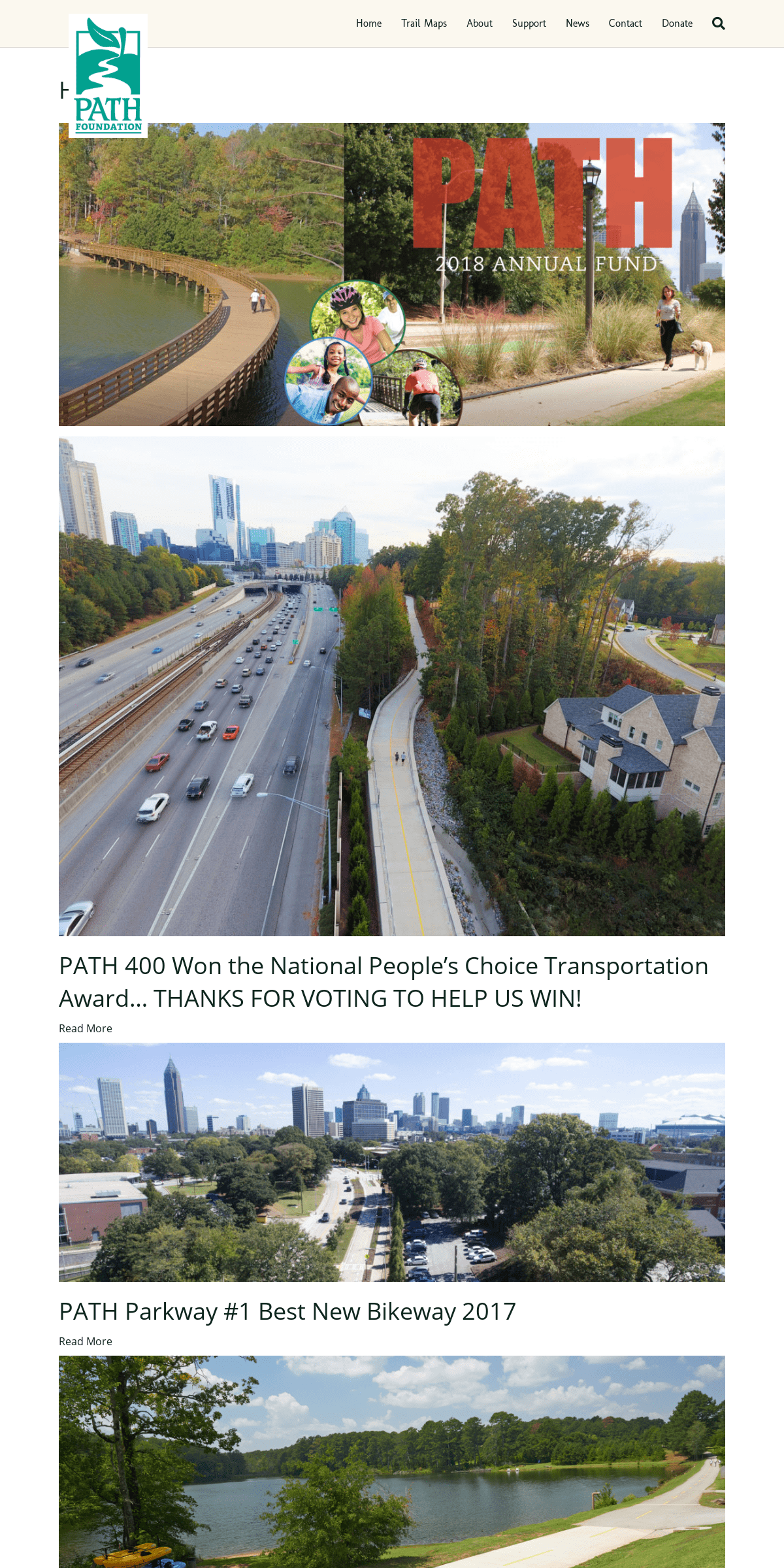
HOME
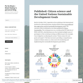
PATH 400 WON THE NATIONAL PEOPLE’S CHOICE TRANSPORTATION AWARD… THANKS FOR VOTING TO HELP US WIN!Read More
PATH PARKWAY #1 BEST NEW BIKEWAY 2017Read More
HELP US BUILD NEW TRAILSDonate Now
GET DIRECTIONS TO TRAILSView Trail Maps
THE PATH FOUNDATION HAS BEEN BUILDING A NETWORK OF OFF-ROAD TRAILS IN AND AROUND ATLANTA FOR WALKERS, RUNNERS, CYCLISTS AND SKATERS FOR MORE THAN 25 YEARS. THIS SYSTEM OF SCENIC GREENWAYS PRESERVE OUR REGION’S FORESTED CHARACTER AND OFFER OPPORTUNITIES FOR FAMILIES TO ENJOYNATURE TOGETHER.
Learn More about PATH Foundation DIRECTIONS TO TRAILSDONATE
NEWS
PATH NEWS
CURIOUS ABOUT OUR NEWEST TRAILS? CHECK OUT THE VIEWS FROM PATH 400, S. PEACHTREE CREEK TRAIL AND THEPATH PARKWAY TRAIL!
Enjoy the view from the PATH 400 trail as you stroll along the tree-lined path, past garden plantings and through the neighborhoods from Lenox Road to Wieuca. The PATH Foundation is partnering with Livable Buckhead and the Buckhead CID and GDOT to build a trail from the Atlanta BeltLine to I-285 and beyond. The first two segments are open between Lenox Road near Piedmont Road to Wieuca Road. Two additional segments are now under construction. Follow along the South Peachtree Creek Trail as it meanders through Mason Mill Park as a boardwalk along the banks of the creek. It connects the ball fields and parking area at Medlock Park to the historic Decatur Waterworks and the Tennis Center at Mason Mill Park. Take a stroll down PATH Parkway, a tree-lined walking and biking facility connecting West Midtown, Georgia Tech, and the Coca-Cola headquarters to Centennial Olympic Park. West Midtown residents, Georgia Tech students, and Coca-Cola employees walking, jogging, or traveling by bike now have a separated facility connecting them to downtown and other PATH trails. The design allows for a row of trees between the bikeway and walkway providing shade for most of the route.SUPPORT PATH
PATH Foundation is a private non-profit organization that needs your financial support. Your tax-deductible contributions enable us to keep building new trails and maintain existing ones. Support the PATH Foundation’s important efforts to create a comprehensive, connected system of greenway trails. PATH’S 25TH ANNIVERSARY VIDEO PATH celebrates 25 years of service to the community as well as another significant milestone—surpassing 250 miles of trail. Watch this video to learn more about our 25th anniversary, or visit our history page to read more about how we got started and where we’re going. RIDING THE GREENBELT Please enjoy this short video highlighting the beauty of the Carrolton Greenbelt. The Carrollton Greenbelt is a sixteen mile long circumferential trail around the City of Carrollton, traversing the University of West Georgia campus, skirts the Sunset Hills Golf Course, visits marshes and parks and scores of neighborhoods. SUBSCRIBE TO OUR NEWSLETTER Facebook __ __ Twitter __ __Youtube __ __
Flickr __ __
Email __ __
PATH Foundation
PO Box 14327
Atlanta, Georgia 30324 Phone: 404.875.PATH (7284) path@pathfoundation.orgDetails
4