2
More Annotations


5


4
Favourite Annotations


2


1
Text
ONX: GPS MAP APPS FOR HUNTING, HIKING & OFF-ROADINGLOG INSTART FREE TRIALPRICINGOFFROADACCOUNTONXMAPS WEB APP 650,000+ miles of trails. 10,000 Adventures and counting. Explore. onX Hunt. Trusted by millions of hunters nationwide. onX Offroad. Go farther with confidence. onX OFFROAD GPS MAPS APP: FIND ATV, DIRT BIKE, UTV, 4X4 TRAILS Off-Road GPS App. Go Farther. Join thousands of off-roaders in planning and discovering 550K+ miles of off-road trails. Keep all of your trails, Tracks, campsites, and markups in one App. Start your free trial today. No credit card required. Get The App. Learn More. OFFROAD TRAILS: FIND THE BEST ATV, DIRT BIKE & SXS Offroad Trails is the staging area for your next adventure. Access maps, trail descriptions, weather and photos to plan your next ATV, dirt bike or SxS trip. BEST HUNTING APPS: GPS LANDOWNERSHIP MAPS FOR IPHONE Maps for hunting, made by hunters. 975 million acres of public land. 10,668 unique hunting units. 421 map overlays and counting. 5,000 game wardens approve. Nationwide public/private. landownership maps. Get maps for all fifty states, with detailed public and private boundaries, landowner names, hunting districts, and more. MOAB OFF-ROAD TRAILS Welcome to the land built for off-roading: Moab, Utah. From the famous (or infamous?) sandstone known as “slickrock,” to boulders the size of houses, to sandy washes and snowy peaks, Moab has varied terrain for every rider and ability. Use your onX Offroad App to find Moab trails for your Jeep, ATV, side-by-side, dirt bike and overland
vehicle.
BEHIND THE REEF: 2020 TRAIL MAP, CONDITIONS & RATING Behind the Reef is a popular ATV and UTV trail, but is wide enough for Jeeps. The rocky and beautiful trail has several options to loop back that vary in length, some quite a bit longer. When starting the route, you'll pass through the Temple Mountain recreation area with ONX: GPS MAP APPS FOR HUNTING, HIKING & OFF-ROADINGLOG INSTART FREE TRIALPRICINGOFFROADACCOUNTONXMAPS WEB APP 650,000+ miles of trails. 10,000 Adventures and counting. Explore. onX Hunt. Trusted by millions of hunters nationwide. onX Offroad. Go farther with confidence. onX OFFROAD GPS MAPS APP: FIND ATV, DIRT BIKE, UTV, 4X4 TRAILS Off-Road GPS App. Go Farther. Join thousands of off-roaders in planning and discovering 550K+ miles of off-road trails. Keep all of your trails, Tracks, campsites, and markups in one App. Start your free trial today. No credit card required. Get The App. Learn More. OFFROAD TRAILS: FIND THE BEST ATV, DIRT BIKE & SXS Offroad Trails is the staging area for your next adventure. Access maps, trail descriptions, weather and photos to plan your next ATV, dirt bike or SxS trip. BEST HUNTING APPS: GPS LANDOWNERSHIP MAPS FOR IPHONE Maps for hunting, made by hunters. 975 million acres of public land. 10,668 unique hunting units. 421 map overlays and counting. 5,000 game wardens approve. Nationwide public/private. landownership maps. Get maps for all fifty states, with detailed public and private boundaries, landowner names, hunting districts, and more. MOAB OFF-ROAD TRAILS Welcome to the land built for off-roading: Moab, Utah. From the famous (or infamous?) sandstone known as “slickrock,” to boulders the size of houses, to sandy washes and snowy peaks, Moab has varied terrain for every rider and ability. Use your onX Offroad App to find Moab trails for your Jeep, ATV, side-by-side, dirt bike and overlandvehicle.
BEHIND THE REEF: 2020 TRAIL MAP, CONDITIONS & RATING Behind the Reef is a popular ATV and UTV trail, but is wide enough for Jeeps. The rocky and beautiful trail has several options to loop back that vary in length, some quite a bit longer. When starting the route, you'll pass through the Temple Mountain recreation area with HIKING GPS MAP APP & HIKING PLANNER Explore 650K+ miles of hiking and backpacking trails with the onX Backcountry App. From day hikes to multi-day backpacking trips, the onX Backcountry app puts HUNTING PROPERTY LINE APP 1. Tap the Map Layers Button in the bottom-left corner of the main screen to open the Map Layers Menu. 2. The Map Layers Menu is divided into two sections: My Layers: layers that are currently available for viewing on the map. Layer Library: storage location for layers not regularly used. 3. In the My Layers section, locate the Map Layer HOW TO USE THE ONX OFFROAD APP FOR YOUR NEXT ADVENTURE onX Offroad is like having 5,000 paper maps in the palm of your hand. It’s accessing the best trail and road data with the tap of a finger. It’s customizing your maps your way with tracked trips, photo Waypoints and downloaded maps. onX Offroad is the ultimate tool for adventure off the pavement.. Below are a few ways to help you make the most of your onX Offroad App. MEDANO PASS: 2020 TRAIL MAP, CONDITIONS & DIFFICULTY Medano Pass, in its early history, was not used by wagons because of the challenging sand on the south side. Since then, it has continued to be ignored for development. To the delight of backcountry travelers, the route, with the exception of signs and gates, remains much the same today as it was a century ago. “Médano” means“dune” in
HOW DO I CHANGE STATES WITHIN THE ONX HUNT APP? Enabling the New State. Tap the Map Layers Button in the bottom-left corner of the main screen. This opens the menu that allows you to customize your map. Tap “Layer Library” on the right side of Map Layers Menu. The Layer Library is a storage location for states andmap layers that are
CHICKEN CORNERS: 2020 TRAIL MAP, CONDITIONS & RATING Chicken Corners. The route winds primarily along the Colorado River, but you can stop to explore some catacomb caves along the way, and the scenery is phenomenal. Chicken Corners travels along a high, steep cliff overlooking the Colorado River. You will likely run into dirt bikers and mountain bikers, so please be respectful. MONACHE MEADOWS: 2020 TRAIL MAP, CONDITIONS & DIFFICULTY Getting There. From Kernville, take Sierra Way north about 20 miles and turn right on Sherman Pass Road. Go another 32 miles following signs to Black Rock Workstation. Continue north 3.5 miles on 21S03 and turn right on 21S36. Go another 3.6 miles and turn left on dirt road34E38. Trailhead is
GET TO KNOW LEAVE NO TRACE According to Leave No Trace Executive Director Dana Watts, “While the concept of Leave No Trace already existed, there was a need identified amongst leaders of the outdoor industry for a program for all people who were getting outside to understand how to minimally impact the outdoors.” HELL’S REVENGE: 2020 TRAIL MAP, CONDITIONS & DIFFICULTY Difficult, long, but very scenic and exciting, this is one of the most popular trails near Moab. Hell's Revenge intertwines with the Slickrock Bike Trail, so be very careful at crosspoints. Bikers have the right of way. Sand Flat Recreation Area has a small fee. When Dan Mick came to Moab in 1973, Hell’s Revenge didn't have a name. BEST DEER HUNTING STATES However, on average these states lead the way when it comes to the number of deer in the woods per square mile. Mississippi tops the list at almost 40 deer per square mile, but Pennsylvania, Wisconsin and Michigan all show an average of more than 30 deer per square mile. Indiana, Alabama, South Carolina and Kentucky all have 23 or more deerper
x-icon
Enter to win an all-expenses-paid elk hunt with Randy Newberg.* Close
*
* Hunt
* Hunt App
* State Coverage
* Hunt GPS Chip
* Pricing
* Hunt Central
* Support
* Draw Odds
* Pricing
* Offroad
* Offroad App
* Inside onX
* Opener is Everything * Landlocked State Lands* About Us
* Ambassadors
* Blog
* Gear
*
* Start Free Trial
* Log In
* Log In Get the AppGet the App
* Hunt
* Hunt App
* State Coverage
* Hunt GPS Chip
* Pricing
* Hunt Central
* Support
* Draw Odds
* Pricing
* Offroad
* Offroad App
* Inside onX
* Opener is Everything * Landlocked State Lands* About Us
* Ambassadors
* Blog
* Gear
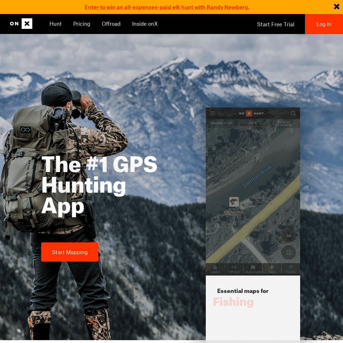
THE #1 GPS HUNTING APP Start Mapping Start mappingStart mapping
ESSENTIAL MAPS FOR
HUNTING
TRAILS
FISHING
LAND OWNERSHIP
CAMPING
WANT TO HUNT WITH
RANDY NEWBERG?
Thanks to the RMEF, you can win an all-expenses-paid elk hunt withRandy Newberg.
Enter Now
PUBLIC / PRIVATE
LAND BOUNDARIES.
The best tool for every hunter, our maps show clearly marked property boundaries, public and private landowner names and more - giving you everything you need to stay legal and ethical. * 121 MILLION private properties * 985 MILLION acres of public land * 421 map overlays and counting * 400,000+ miles of trailsNO SERVICE.
NO PROBLEM.
Access saved maps from anywhere and locate yourself in the wild. The GPS in your mobile device works perfectly offline, even when the network is nonexistent. Get Off Grid Now Get off grid nowGet off grid now
GET THE
ONX OFFROAD APP
Explore more than 240,000 miles of open roads and trails and 985 million acres of public land.Learn More
Download for free
Download for free
Asset 2droid
SYNC ALL YOUR DATA
ACROSS DEVICES.
Use maps when and where you need them—scout from a home desktop and explore with your GPS unit or mobile devices in the field. * Desktop & laptop computers * Apple & Android smart phones * Apple & Android tablets * Garmin GPS devicesONX MANIFESTO
* onX Manifesto
Close
START YOUR FREE TRIAL. Start Mapping Start mapping nowStart mapping now
* Find a Dealer
* Become a Dealer
* Hunting Areas
* Pro Purchase
* Support
* Hunt Central
* Contact Us
* Careers
* Stories
* Redeem Card
* Business Inquiries * Hunt App Reviews logo-facebook Created with Sketch. logo-instagram Created with Sketch. logo-twitter Created with Sketch. logo-youtube Created with Sketch. Terms of Use Privacy Policy� 2019 onXmaps
Details
2