5
More Annotations


1


5
Favourite Annotations


6


2
Text
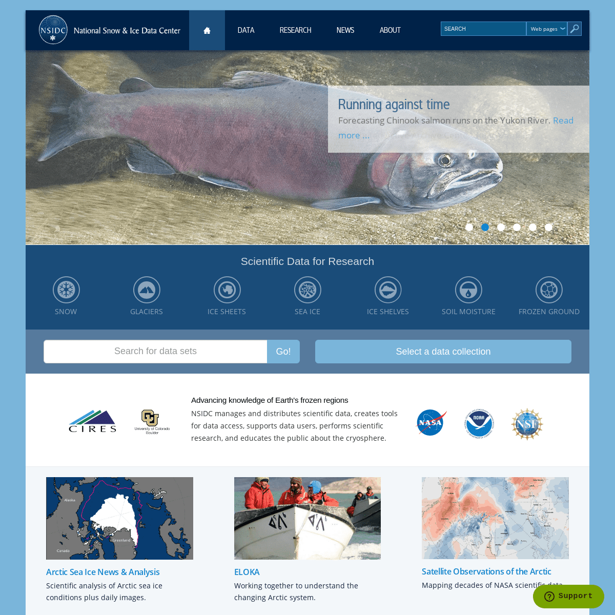
NATIONAL SNOW AND ICE DATA CENTER | Arctic sea ice has likely reached its maximum extent for the year, at 14.77 million square kilometers (5.70 million square miles) on March 21, 2021, according to scientists at the National Snow and Ice Data Center (NSIDC) at the University of Colorado Boulder. The 2021 maximum is tied with 2007 for seventh lowest in the 43-year satellite record. ARCTIC SEA ICE NEWS AND ANALYSIS DATA SETS | NATIONAL SNOW AND ICE DATA CENTER 1 day. SEA ICE CONCENTRATION. EUMETSAT OSI SAF Global Sea Ice Concentration Reprocessing Data, Version 1 (NSIDC-0508) N: 90, S: -90, E: 180, W: -180. 1978/10/27 to 2009/10/24. 25 km. SEA ICE CONCENTRATION. Global Products for Ice Concentration, Ice Edge, Ice Type, Sea Ice Drift, Version 1 (NSIDC-0678) 2005/01/01. MAY | 2021 | ARCTIC SEA ICE NEWS AND ANALYSIS Figure 2a. The graph above shows Arctic sea ice extent as of May 4, 2021, along with daily ice extent data for four previous years and 2012, the record low year. 2021 is shown in blue, 2020 in green, 2019 in orange, 2018 in brown, 2017 in magenta, and 2012 in dashed brown. ICESAT-2 DATA SETS AT NSIDC ICESat-2 Data Sets at NSIDC. The following tables list the ICESat-2 data sets that are currently available at NSIDC. Version 4 data sets are being released as they become available. For some ATL products Version 3, 2, or 1 is the most recent product version. Current
Version.
SEPTEMBER | 2020 | ARCTIC SEA ICE NEWS AND ANALYSIS September 21, 2020. On September 15, Arctic sea ice likely reached its annual minimum extent of 3.74 million square kilometers (1.44 million square miles). The minimum ice extent is the second lowest in the 42-year-old satellite record, reinforcing the long-term downward trend in Arctic ice extent. Sea ice extent will now begin its seasonal DATA SETS | NATIONAL SNOW AND ICE DATA CENTER 2009/01/01 to 2017/10/12. FREEZE/THAW. High Mountain Asia Average Glacier Thickness Change from Multi-Sensor DEMs, Version 1. 1974/01/01 to 2017/12/31. GLACIER THICKNESS/ICE SHEET THICKNESS. High Mountain Asia COAWST 6-Hourly 4km Regional Climate Model Simulations, Version 1. 1999/10/01 to 2014/10/01. CHARCTIC INTERACTIVE SEA ICE GRAPH Combination chart with 52 data series. (Area of ocean with at least 15% sea ice) The chart has 1 X axis displaying Date. Range: 1 to 369.65. The chart has 1 Y axis displaying Extent (Millions of square kilometers). Range: 0 to 18. View as data table. Chart graphic. Created with Highcharts 7.1.1. DMSP SSM/I-SSMIS DAILY POLAR GRIDDED BRIGHTNESS This data set provides daily gridded brightness temperatures derived from passive microwave sensors and distributed in a polar stereographic projection. Orbital data from nine channels and for each 24-hour period are mapped to respective grid cells using a simple SEA ICE INDEX FTP DIRECTORY STRUCTURE CHANGING On Thin Ice: Expedition to a Crumbling Ice Shelf. Scientists blog from Antarctica and provide a glimpse of what it's like to do research inthe field.
NATIONAL SNOW AND ICE DATA CENTER | Arctic sea ice has likely reached its maximum extent for the year, at 14.77 million square kilometers (5.70 million square miles) on March 21, 2021, according to scientists at the National Snow and Ice Data Center (NSIDC) at the University of Colorado Boulder. The 2021 maximum is tied with 2007 for seventh lowest in the 43-year satellite record. ARCTIC SEA ICE NEWS AND ANALYSIS DATA SETS | NATIONAL SNOW AND ICE DATA CENTER 1 day. SEA ICE CONCENTRATION. EUMETSAT OSI SAF Global Sea Ice Concentration Reprocessing Data, Version 1 (NSIDC-0508) N: 90, S: -90, E: 180, W: -180. 1978/10/27 to 2009/10/24. 25 km. SEA ICE CONCENTRATION. Global Products for Ice Concentration, Ice Edge, Ice Type, Sea Ice Drift, Version 1 (NSIDC-0678) 2005/01/01. MAY | 2021 | ARCTIC SEA ICE NEWS AND ANALYSIS Figure 2a. The graph above shows Arctic sea ice extent as of May 4, 2021, along with daily ice extent data for four previous years and 2012, the record low year. 2021 is shown in blue, 2020 in green, 2019 in orange, 2018 in brown, 2017 in magenta, and 2012 in dashed brown. ICESAT-2 DATA SETS AT NSIDC ICESat-2 Data Sets at NSIDC. The following tables list the ICESat-2 data sets that are currently available at NSIDC. Version 4 data sets are being released as they become available. For some ATL products Version 3, 2, or 1 is the most recent product version. CurrentVersion.
SEPTEMBER | 2020 | ARCTIC SEA ICE NEWS AND ANALYSIS September 21, 2020. On September 15, Arctic sea ice likely reached its annual minimum extent of 3.74 million square kilometers (1.44 million square miles). The minimum ice extent is the second lowest in the 42-year-old satellite record, reinforcing the long-term downward trend in Arctic ice extent. Sea ice extent will now begin its seasonal DATA SETS | NATIONAL SNOW AND ICE DATA CENTER 2009/01/01 to 2017/10/12. FREEZE/THAW. High Mountain Asia Average Glacier Thickness Change from Multi-Sensor DEMs, Version 1. 1974/01/01 to 2017/12/31. GLACIER THICKNESS/ICE SHEET THICKNESS. High Mountain Asia COAWST 6-Hourly 4km Regional Climate Model Simulations, Version 1. 1999/10/01 to 2014/10/01. CHARCTIC INTERACTIVE SEA ICE GRAPH Combination chart with 52 data series. (Area of ocean with at least 15% sea ice) The chart has 1 X axis displaying Date. Range: 1 to 369.65. The chart has 1 Y axis displaying Extent (Millions of square kilometers). Range: 0 to 18. View as data table. Chart graphic. Created with Highcharts 7.1.1. DMSP SSM/I-SSMIS DAILY POLAR GRIDDED BRIGHTNESS This data set provides daily gridded brightness temperatures derived from passive microwave sensors and distributed in a polar stereographic projection. Orbital data from nine channels and for each 24-hour period are mapped to respective grid cells using a simple SEA ICE INDEX FTP DIRECTORY STRUCTURE CHANGING On Thin Ice: Expedition to a Crumbling Ice Shelf. Scientists blog from Antarctica and provide a glimpse of what it's like to do research inthe field.
| NATIONAL SNOW AND ICE DATA CENTER Relative abundance of ground ice in the upper 20 m is estimated in percent volume (>20 percent, 10-20 percent, 20 percent, 10-20 percent,Details
6