2
More Annotations


3


2
Favourite Annotations


4


4
Text
LIFE IN TANDEM
Filmed in the Redwood parks, Endor–the forest moon– is a place on such a grand scale that it piques our imaginations. Dense fog rolls off the Pacific, thick and low in the summer, thinner and high in the winter, keeping temperatures generally in the 50s and 60s and creating an aura of true mystery.OUR TRAILER
A few months back, Nick drove from Boston to Ohio and back to pick up our 1969 Serro Scotty HiLander. She's got a lot of history and the dents (and, ok, some wood rot) to prove it - but we love her. We hope she makes it to Seattle in once piece In addition to GOLDEN GATE, GOLDEN STATE While in San Francisco and Sonoma we listened to: The Stable Song by Gregory Alan Isakov Perfectly Aligned by Milo Greene Here it Goes by Jimmy Eat World Click the links provided for an enhanced reading experience! "This tastes terrible!" Adam quipped in his Kiwi accent after taking a gulp from a tall, silver can.ROCKY MOUNTAINS
Well don’t worry. Nick had picked out the perfect route from Santa Fe to Vail that would minimize our time in the mountains. We drove through miles of a beautiful hilly highway in the Carson National Forest, nothing but the occasional dirt logging road interrupting a thick blanket of tall dark trees. A VACATION FROM OUR VACATION While Driving from Santa Fe to Vail, Colorado, we listened to: Go Do by Jonsi The Farsighted by Five Iron Frenzy Half Moon Rising by Yonder Mountain String Band That's right! The blog is being resurrected. I didn't think it would happen myself, but one day I came home and found that Nick had written a beautifulLEAVING TOWN
We moved out of our place the other day and the reality of this adventure is beginning to sink in. We no longer have jobs or a home to go back to, and we don't have jobs or homes in Seattle either. We said goodbye to some of the best friends we have. A lot THE LAND OF RUTH AND ORPAH, OR BIG BEND: REDUX While traveling through Arches National Park, we listened to: Hengilás by Jonsi Sorrowing Man by City and Colour Hallelujah, What a Savior by Ascend the Hill Moab is boulders and monoliths cast down by Mars. It is blood-red sandstone erupting from the barren desert, pinching breathtakingly tight canyons between corpulent towers and loafs of otherworldlyMILE MARKER ZERO
Disclaimer: It is not customary to take a pre-vacation before your other vacation begins. But, as a rule, when we are presented with an opportunity to zip down to sunny south Florida for a weekend we will always take it. Even if it just happens to be the day after you moveout of your
SUMMER LAND
The next morning broke crystal clear and we rustled up a few flames on the fire. Soon, with a pot of coffee and a cast iron skillet of sizzling bacon, navy blue skies beckoned us into the thick shade of the pine forest and onto the mountainside. We set off from our site on the fabled Wonderland Trail and immediately crossed the White River on a series of ramshackle wooden bridges, emerging onARE WE THERE YET?
We have been driving. A lot. Too much, perhaps, but a week in North Carolina wasn't in the original plan and we are trying to make up for lost time. The odometer on the trusty Jeep tells us that so far we have logged 4,500 miles (that's over 100 hours behind the wheel). Justsince
LIFE IN TANDEM
Filmed in the Redwood parks, Endor–the forest moon– is a place on such a grand scale that it piques our imaginations. Dense fog rolls off the Pacific, thick and low in the summer, thinner and high in the winter, keeping temperatures generally in the 50s and 60s and creating an aura of true mystery.OUR TRAILER
A few months back, Nick drove from Boston to Ohio and back to pick up our 1969 Serro Scotty HiLander. She's got a lot of history and the dents (and, ok, some wood rot) to prove it - but we love her. We hope she makes it to Seattle in once piece In addition to SUBSCRIBE | LIFE IN TANDEM Follow us! Subscribe to the RSS and Comment RSS feeds: RSS / Comments For posts delivered straight to your very own inbox, click on "Follow Us" in the sidebar to A VACATION FROM OUR VACATION While Driving from Santa Fe to Vail, Colorado, we listened to: Go Do by Jonsi The Farsighted by Five Iron Frenzy Half Moon Rising by Yonder Mountain String Band That's right! The blog is being resurrected. I didn't think it would happen myself, but one day I came home and found that Nick had written a beautiful THIS ISN’T AT ALL HOW WE PICTURED IT IN OUR HEADS (OR Well friends, we had been building up some great blog material for you. There was going to be a funny post about how the first night in the Scotty was less than we had imagined, the artificial light from the WalMart spotlights seeping into every seam, the sound of shopping carts and car doors harmonizing into our second-rate lullaby, the ice on the pavement a reminder that it was in the low DEAD HORSE | LIFE IN TANDEM While traveling through Canyonlands National Park we listened to: Fanfare for the Common Man and The Rodeo Suite by Aaron Copland O' Death by Noah Gundersen Feel free to listen as you read along. I'd never seen the Grand Canyon when I first set foot at the edge of the Dead Horse. I stiffened a little, involuntarily,EXPLORATION
While in Bryce Canyon, we listened to: Kodachrome and Loves Me Like a Rock by Paul Simon I’m Totally Not Down With Rob’s Alien by Minus the Bear October by Eric Whitaker. The park ranger wasn’t exactly friendly, and we didn’t blame him. SAUSALITO | LIFE IN TANDEM As we locked up the Vibe and began mounting up for the short bike ride to the ferry terminal, a rented RV backed into the vacant spot beside ours, a blonde woman MOAB | LIFE IN TANDEM These songs capture the spirit of our time in Capitol Reef National Park: Roaring Forties by Lowercase Noises Idaho by Gregory Alan Isakov Colonizer by Canopy Climbers Feel free to listen as you read along. Of Utah’s five National Parks, Capitol Reef is the least impressive. PINK ADOBE | LIFE IN TANDEM There’s something distinctly Catholic about the Santa Fe area and it’s refreshing. Whether it’s a result of that sacred holiness instilled in me by the rich tradition of my mother’s parents or my four years discovering truth in faith at a Jesuit university, these places grab my soul and tug at it. C.S. Lewis asks the question in (arguably) his best work, Till We Have Faces, “Why areLIFE IN TANDEM
Filmed in the Redwood parks, Endor–the forest moon– is a place on such a grand scale that it piques our imaginations. Dense fog rolls off the Pacific, thick and low in the summer, thinner and high in the winter, keeping temperatures generally in the 50s and 60s and creating an aura of true mystery. ABOUT US | LIFE IN TANDEM Photo by The Studio Noir We are two young dreamers who met in 2006, got married in 2010, and bought a home in Boston in 2012. Things were good, we were settling down. We were about to get a dog. But we figured we could rent the house and the dog could wait, so weOUR TRAILER
A few months back, Nick drove from Boston to Ohio and back to pick up our 1969 Serro Scotty HiLander. She's got a lot of history and the dents (and, ok, some wood rot) to prove it - but we love her. We hope she makes it to Seattle in once piece In addition toROCKY MOUNTAINS
Well don’t worry. Nick had picked out the perfect route from Santa Fe to Vail that would minimize our time in the mountains. We drove through miles of a beautiful hilly highway in the Carson National Forest, nothing but the occasional dirt logging road interrupting a thick blanket of tall dark trees.LEAVING TOWN
We moved out of our place the other day and the reality of this adventure is beginning to sink in. We no longer have jobs or a home to go back to, and we don't have jobs or homes in Seattle either. We said goodbye to some of the best friends we have. A lotMILE MARKER ZERO
Disclaimer: It is not customary to take a pre-vacation before your other vacation begins. But, as a rule, when we are presented with an opportunity to zip down to sunny south Florida for a weekend we will always take it. Even if it just happens to be the day after you moveout of your
TRAILER HEAVEN
We've been incognito for a few days, licking our wounds and trying to find our way forward in the midst of the Scotty tragedy. Yes, I'm being overly dramatic. And yes, we're back on the road again, at last. I'm currently writing from the passenger seat of FIREWOOD | LIFE IN TANDEM The Vibe was in the shop getting some small repairs after our long trip, so we decided we’d tent camp and go light for the weekend. We left the city under a mantle of smothering morning fog, headed south and east through the Muckleshoot Reservation (with a brief stop for fireworks) and into the densely forested foothills past Enumclaw, the names of the towns through which we passed rollingARE WE THERE YET?
We have been driving. A lot. Too much, perhaps, but a week in North Carolina wasn't in the original plan and we are trying to make up for lost time. The odometer on the trusty Jeep tells us that so far we have logged 4,500 miles (that's over 100 hours behind the wheel). Justsince
PINK ADOBE | LIFE IN TANDEM There’s something distinctly Catholic about the Santa Fe area and it’s refreshing. Whether it’s a result of that sacred holiness instilled in me by the rich tradition of my mother’s parents or my four years discovering truth in faith at a Jesuit university, these places grab my soul and tug at it. C.S. Lewis asks the question in (arguably) his best work, Till We Have Faces, “Why areLIFE IN TANDEM
Filmed in the Redwood parks, Endor–the forest moon– is a place on such a grand scale that it piques our imaginations. Dense fog rolls off the Pacific, thick and low in the summer, thinner and high in the winter, keeping temperatures generally in the 50s and 60s and creating an aura of true mystery. DIXIE NATIONAL FOREST While in Bryce Canyon, we listened to: Kodachrome and Loves Me Like a Rock by Paul Simon I’m Totally Not Down With Rob’s Alien by Minus the Bear October by Eric Whitaker. The park ranger wasn’t exactly friendly, and we didn’t blame him. THE LAND OF RUTH AND ORPAH, OR BIG BEND: REDUX While traveling through Arches National Park, we listened to: Hengilás by Jonsi Sorrowing Man by City and Colour Hallelujah, What a Savior by Ascend the Hill Moab is boulders and monoliths cast down by Mars. It is blood-red sandstone erupting from the barren desert, pinching breathtakingly tight canyons between corpulent towers and loafs of otherworldly THIS ISN’T AT ALL HOW WE PICTURED IT IN OUR HEADS (OR Well friends, we had been building up some great blog material for you. There was going to be a funny post about how the first night in the Scotty was less than we had imagined, the artificial light from the WalMart spotlights seeping into every seam, the sound of shopping carts and car doors harmonizing into our second-rate lullaby, the ice on the pavement a reminder that it was in the low STARS | LIFE IN TANDEM Roy’s Motel and the adjacent gas station look like a scene out of No Country For Old Men. A white Lincoln sits at rest next to a building with white washed walls and roof and, besides the exorbitantly priced fueling station and the shack of a Post Office, everything looks as if it’s closed and has been for years.COPLEY SQUARE
Posts about Copley Square written by Kelly + Nick. While in Page, Arizona and the Grand Canyon, we listened to: Compass by Jamie Liddell Big Iron by Marty Robbins Ring of Fire by Johnny Cash Feel free to click the links above to listen while you read. FIREWOOD | LIFE IN TANDEM The Vibe was in the shop getting some small repairs after our long trip, so we decided we’d tent camp and go light for the weekend. We left the city under a mantle of smothering morning fog, headed south and east through the Muckleshoot Reservation (with a brief stop for fireworks) and into the densely forested foothills past Enumclaw, the names of the towns through which we passed rollingCATASTROPHE
Posts about Catastrophe written by Kelly + Nick. Well friends, we had been building up some great blog material for you. There was going to be a funny post about how the first night in the Scotty was less than we had imagined, the artificial light from the WalMart spotlights seeping into every seam, the sound of shopping carts and car doors harmonizing into our second-rate lullaby, the ice onSMITH RIVER
The northernmost counties of California are less conspicuous than their southern counterparts and, at times, are downright rural. Through much of our drive up the California coast we could feel the subtle crush of humanity–perhaps because we had just come from several weeks in the relatively empty mountain west–and even in wilder places like Big Sur and Joshua Tree, we felt sandwichedRUSSIAN DISTRICT
Posts about Russian District written by Kelly + Nick. While in San Francisco and Sonoma we listened to: The Stable Song by Gregory Alan Isakov Perfectly Aligned by Milo Greene Here it Goes by Jimmy Eat World Click the links provided for an enhanced reading experience!LIFE IN TANDEM
Filmed in the Redwood parks, Endor–the forest moon– is a place on such a grand scale that it piques our imaginations. Dense fog rolls off the Pacific, thick and low in the summer, thinner and high in the winter, keeping temperatures generally in the 50s and 60s and creating an aura of true mystery. ABOUT US | LIFE IN TANDEM Photo by The Studio Noir We are two young dreamers who met in 2006, got married in 2010, and bought a home in Boston in 2012. Things were good, we were settling down. We were about to get a dog. But we figured we could rent the house and the dog could wait, so weOUR TRAILER
A few months back, Nick drove from Boston to Ohio and back to pick up our 1969 Serro Scotty HiLander. She's got a lot of history and the dents (and, ok, some wood rot) to prove it - but we love her. We hope she makes it to Seattle in once piece In addition to KIRK CREEK CAMPGROUND While in Los Angeles and Big Sur we listened to: 1957 and Son, My Son by Milo Greene Lonesome Dreams by Lord Huron We cannot recommend highly enough clicking the links above to listen while you read along, then purchasing both albums and listening to them on repeat.ROCKY MOUNTAINS
Well don’t worry. Nick had picked out the perfect route from Santa Fe to Vail that would minimize our time in the mountains. We drove through miles of a beautiful hilly highway in the Carson National Forest, nothing but the occasional dirt logging road interrupting a thick blanket of tall dark trees. 4×4 | LIFE IN TANDEM Posts about 4×4 written by Kelly + Nick. While traveling through Arches National Park, we listened to: Hengilás by Jonsi Sorrowing Man by City and Colour Hallelujah, What a Savior by Ascend the Hill. Moab is boulders and monoliths cast down by Mars.IN GOD’S COUNTRY
"So be sure when you step. Step with care and great tact and remember that life's A great balancing act. Just never forget to be dexterous and deft. And never mix up your right foot with your left." -Dr. Seuss, "Oh, the Places You'll Go" While in Joshua Tree National Park we listened to: Love REDWOODS NATIONAL PARK The northernmost counties of California are less conspicuous than their southern counterparts and, at times, are downright rural. Through much of our drive up the California coast we could feel the subtle crush of humanity–perhaps because we had just come from several weeks in the relatively empty mountain west–and even in wilder places like Big Sur and Joshua Tree, we felt sandwiched MOAB | LIFE IN TANDEM These songs capture the spirit of our time in Capitol Reef National Park: Roaring Forties by Lowercase Noises Idaho by Gregory Alan Isakov Colonizer by Canopy Climbers Feel free to listen as you read along. Of Utah’s five National Parks, Capitol Reef is the least impressive. THIS ISN’T AT ALL HOW WE PICTURED IT IN OUR HEADS (OR Well friends, we had been building up some great blog material for you. There was going to be a funny post about how the first night in the Scotty was less than we had imagined, the artificial light from the WalMart spotlights seeping into every seam, the sound of shopping carts and car doors harmonizing into our second-rate lullaby, the ice on the pavement a reminder that it was in the lowLIFE IN TANDEM
Filmed in the Redwood parks, Endor–the forest moon– is a place on such a grand scale that it piques our imaginations. Dense fog rolls off the Pacific, thick and low in the summer, thinner and high in the winter, keeping temperatures generally in the 50s and 60s and creating an aura of true mystery. ABOUT US | LIFE IN TANDEM Photo by The Studio Noir We are two young dreamers who met in 2006, got married in 2010, and bought a home in Boston in 2012. Things were good, we were settling down. We were about to get a dog. But we figured we could rent the house and the dog could wait, so weOUR TRAILER
A few months back, Nick drove from Boston to Ohio and back to pick up our 1969 Serro Scotty HiLander. She's got a lot of history and the dents (and, ok, some wood rot) to prove it - but we love her. We hope she makes it to Seattle in once piece In addition to KIRK CREEK CAMPGROUND While in Los Angeles and Big Sur we listened to: 1957 and Son, My Son by Milo Greene Lonesome Dreams by Lord Huron We cannot recommend highly enough clicking the links above to listen while you read along, then purchasing both albums and listening to them on repeat.ROCKY MOUNTAINS
Well don’t worry. Nick had picked out the perfect route from Santa Fe to Vail that would minimize our time in the mountains. We drove through miles of a beautiful hilly highway in the Carson National Forest, nothing but the occasional dirt logging road interrupting a thick blanket of tall dark trees. 4×4 | LIFE IN TANDEM Posts about 4×4 written by Kelly + Nick. While traveling through Arches National Park, we listened to: Hengilás by Jonsi Sorrowing Man by City and Colour Hallelujah, What a Savior by Ascend the Hill. Moab is boulders and monoliths cast down by Mars.IN GOD’S COUNTRY
"So be sure when you step. Step with care and great tact and remember that life's A great balancing act. Just never forget to be dexterous and deft. And never mix up your right foot with your left." -Dr. Seuss, "Oh, the Places You'll Go" While in Joshua Tree National Park we listened to: Love REDWOODS NATIONAL PARK The northernmost counties of California are less conspicuous than their southern counterparts and, at times, are downright rural. Through much of our drive up the California coast we could feel the subtle crush of humanity–perhaps because we had just come from several weeks in the relatively empty mountain west–and even in wilder places like Big Sur and Joshua Tree, we felt sandwiched MOAB | LIFE IN TANDEM These songs capture the spirit of our time in Capitol Reef National Park: Roaring Forties by Lowercase Noises Idaho by Gregory Alan Isakov Colonizer by Canopy Climbers Feel free to listen as you read along. Of Utah’s five National Parks, Capitol Reef is the least impressive. THIS ISN’T AT ALL HOW WE PICTURED IT IN OUR HEADS (OR Well friends, we had been building up some great blog material for you. There was going to be a funny post about how the first night in the Scotty was less than we had imagined, the artificial light from the WalMart spotlights seeping into every seam, the sound of shopping carts and car doors harmonizing into our second-rate lullaby, the ice on the pavement a reminder that it was in the lowTHE PROMISED LAND
While in Zion National Park we listened to: Down in the Valley by The Head and the Heart At the Bird's Foot by City and Colour Heartbeats by Jose Gonzalez The only other idiot I came across attempting the Narrows in the spring without a drysuit was wearing a New England Patriots hat. It made JOSHUA TREE NATIONAL PARK Roy’s Motel and the adjacent gas station look like a scene out of No Country For Old Men. A white Lincoln sits at rest next to a building with white washed walls and roof and, besides the exorbitantly priced fueling station and the shack of a Post Office, everything looks as ifBOMBS OVER BOYLSTON
For a photographer, Lower Antelope is a luminescent dream. There is incredible nuance in the way the diffuse light p lays in highlights and shadows on the rock walls, painting the same sandstone thousands of different shades and hues. While many areas are mainly orange and rust-color ed, sometimes we would turn a corner to find a tiny chamber of rosy pink or a ledge of deep violet, like anLIFE IN TANDEM
Filmed in the Redwood parks, Endor–the forest moon– is a place on such a grand scale that it piques our imaginations. Dense fog rolls off the Pacific, thick and low in the summer, thinner and high in the winter, keeping temperatures generally in the 50s and 60s and creating an aura of true mystery. ABOUT US | LIFE IN TANDEM Photo by The Studio Noir We are two young dreamers who met in 2006, got married in 2010, and bought a home in Boston in 2012. Things were good, we were settling down. We were about to get a dog. But we figured we could rent the house and the dog could wait, so weOUR TRAILER
A few months back, Nick drove from Boston to Ohio and back to pick up our 1969 Serro Scotty HiLander. She's got a lot of history and the dents (and, ok, some wood rot) to prove it - but we love her. We hope she makes it to Seattle in once piece In addition to KIRK CREEK CAMPGROUND While in Los Angeles and Big Sur we listened to: 1957 and Son, My Son by Milo Greene Lonesome Dreams by Lord Huron We cannot recommend highly enough clicking the links above to listen while you read along, then purchasing both albums and listening to them on repeat.ROCKY MOUNTAINS
Well don’t worry. Nick had picked out the perfect route from Santa Fe to Vail that would minimize our time in the mountains. We drove through miles of a beautiful hilly highway in the Carson National Forest, nothing but the occasional dirt logging road interrupting a thick blanket of tall dark trees. 4×4 | LIFE IN TANDEM Posts about 4×4 written by Kelly + Nick. While traveling through Arches National Park, we listened to: Hengilás by Jonsi Sorrowing Man by City and Colour Hallelujah, What a Savior by Ascend the Hill. Moab is boulders and monoliths cast down by Mars.IN GOD’S COUNTRY
"So be sure when you step. Step with care and great tact and remember that life's A great balancing act. Just never forget to be dexterous and deft. And never mix up your right foot with your left." -Dr. Seuss, "Oh, the Places You'll Go" While in Joshua Tree National Park we listened to: Love REDWOODS NATIONAL PARK The northernmost counties of California are less conspicuous than their southern counterparts and, at times, are downright rural. Through much of our drive up the California coast we could feel the subtle crush of humanity–perhaps because we had just come from several weeks in the relatively empty mountain west–and even in wilder places like Big Sur and Joshua Tree, we felt sandwiched MOAB | LIFE IN TANDEM These songs capture the spirit of our time in Capitol Reef National Park: Roaring Forties by Lowercase Noises Idaho by Gregory Alan Isakov Colonizer by Canopy Climbers Feel free to listen as you read along. Of Utah’s five National Parks, Capitol Reef is the least impressive. THIS ISN’T AT ALL HOW WE PICTURED IT IN OUR HEADS (OR Well friends, we had been building up some great blog material for you. There was going to be a funny post about how the first night in the Scotty was less than we had imagined, the artificial light from the WalMart spotlights seeping into every seam, the sound of shopping carts and car doors harmonizing into our second-rate lullaby, the ice on the pavement a reminder that it was in the lowLIFE IN TANDEM
Filmed in the Redwood parks, Endor–the forest moon– is a place on such a grand scale that it piques our imaginations. Dense fog rolls off the Pacific, thick and low in the summer, thinner and high in the winter, keeping temperatures generally in the 50s and 60s and creating an aura of true mystery. ABOUT US | LIFE IN TANDEM Photo by The Studio Noir We are two young dreamers who met in 2006, got married in 2010, and bought a home in Boston in 2012. Things were good, we were settling down. We were about to get a dog. But we figured we could rent the house and the dog could wait, so weOUR TRAILER
A few months back, Nick drove from Boston to Ohio and back to pick up our 1969 Serro Scotty HiLander. She's got a lot of history and the dents (and, ok, some wood rot) to prove it - but we love her. We hope she makes it to Seattle in once piece In addition to KIRK CREEK CAMPGROUND While in Los Angeles and Big Sur we listened to: 1957 and Son, My Son by Milo Greene Lonesome Dreams by Lord Huron We cannot recommend highly enough clicking the links above to listen while you read along, then purchasing both albums and listening to them on repeat.ROCKY MOUNTAINS
Well don’t worry. Nick had picked out the perfect route from Santa Fe to Vail that would minimize our time in the mountains. We drove through miles of a beautiful hilly highway in the Carson National Forest, nothing but the occasional dirt logging road interrupting a thick blanket of tall dark trees. 4×4 | LIFE IN TANDEM Posts about 4×4 written by Kelly + Nick. While traveling through Arches National Park, we listened to: Hengilás by Jonsi Sorrowing Man by City and Colour Hallelujah, What a Savior by Ascend the Hill. Moab is boulders and monoliths cast down by Mars.IN GOD’S COUNTRY
"So be sure when you step. Step with care and great tact and remember that life's A great balancing act. Just never forget to be dexterous and deft. And never mix up your right foot with your left." -Dr. Seuss, "Oh, the Places You'll Go" While in Joshua Tree National Park we listened to: Love REDWOODS NATIONAL PARK The northernmost counties of California are less conspicuous than their southern counterparts and, at times, are downright rural. Through much of our drive up the California coast we could feel the subtle crush of humanity–perhaps because we had just come from several weeks in the relatively empty mountain west–and even in wilder places like Big Sur and Joshua Tree, we felt sandwiched MOAB | LIFE IN TANDEM These songs capture the spirit of our time in Capitol Reef National Park: Roaring Forties by Lowercase Noises Idaho by Gregory Alan Isakov Colonizer by Canopy Climbers Feel free to listen as you read along. Of Utah’s five National Parks, Capitol Reef is the least impressive. THIS ISN’T AT ALL HOW WE PICTURED IT IN OUR HEADS (OR Well friends, we had been building up some great blog material for you. There was going to be a funny post about how the first night in the Scotty was less than we had imagined, the artificial light from the WalMart spotlights seeping into every seam, the sound of shopping carts and car doors harmonizing into our second-rate lullaby, the ice on the pavement a reminder that it was in the lowTHE PROMISED LAND
While in Zion National Park we listened to: Down in the Valley by The Head and the Heart At the Bird's Foot by City and Colour Heartbeats by Jose Gonzalez The only other idiot I came across attempting the Narrows in the spring without a drysuit was wearing a New England Patriots hat. It made JOSHUA TREE NATIONAL PARK Roy’s Motel and the adjacent gas station look like a scene out of No Country For Old Men. A white Lincoln sits at rest next to a building with white washed walls and roof and, besides the exorbitantly priced fueling station and the shack of a Post Office, everything looks as ifBOMBS OVER BOYLSTON
For a photographer, Lower Antelope is a luminescent dream. There is incredible nuance in the way the diffuse light p lays in highlights and shadows on the rock walls, painting the same sandstone thousands of different shades and hues. While many areas are mainly orange and rust-color ed, sometimes we would turn a corner to find a tiny chamber of rosy pink or a ledge of deep violet, like anLIFE IN TANDEM
While in Mt. Rainier National Park we listened to: Human by Daughter Mystic by Joshua James On the Way Home by John Mayer You can listen,too, by
ABOUT US | LIFE IN TANDEM Photo by The Studio Noir We are two young dreamers who met in 2006, got married in 2010, and bought a home in Boston in 2012. Things were good, we were settling down. We were about to get a dog. But we figured we could rent the house and the dog could wait, so we KIRK CREEK CAMPGROUND While in Los Angeles and Big Sur we listened to: 1957 and Son, My Son by Milo Greene Lonesome Dreams by Lord Huron We cannot recommend highly enough clicking the links above to listen while you read along, then purchasing both albums and listening to them on repeat.OUR TRAILER
A few months back, Nick drove from Boston to Ohio and back to pick up our 1969 Serro Scotty HiLander. She's got a lot of history and the dents (and, ok, some wood rot) to prove it - but we love her. We hope she makes it to Seattle in once piece In addition to 4×4 | LIFE IN TANDEM Posts about 4×4 written by Kelly + Nick. While traveling through Arches National Park, we listened to: Hengilás by Jonsi Sorrowing Man by City and Colour Hallelujah, What a Savior by Ascend the Hill. Moab is boulders and monoliths cast down by Mars.IN GOD’S COUNTRY
"So be sure when you step. Step with care and great tact and remember that life's A great balancing act. Just never forget to be dexterous and deft. And never mix up your right foot with your left." -Dr. Seuss, "Oh, the Places You'll Go" While in Joshua Tree National Park we listened to: Love REDWOODS NATIONAL PARK The northernmost counties of California are less conspicuous than their southern counterparts and, at times, are downright rural. Through much of our drive up the California coast we could feel the subtle crush of humanity–perhaps because we had just come from several weeks in the relatively empty mountain west–and even in wilder places like Big Sur and Joshua Tree, we felt sandwiched LOWER ANTELOPE CANYON While in Page, Arizona and the Grand Canyon, we listened to: Compass by Jamie Liddell Big Iron by Marty Robbins Ring of Fire by Johnny Cash Feel free to click the links above to listen while you read. MOAB | LIFE IN TANDEM These songs capture the spirit of our time in Capitol Reef National Park: Roaring Forties by Lowercase Noises Idaho by Gregory Alan Isakov Colonizer by Canopy Climbers Feel free to listen as you read along. Of Utah’s five National Parks, Capitol Reef is the least impressive. THIS ISN’T AT ALL HOW WE PICTURED IT IN OUR HEADS (OR Well friends, we had been building up some great blog material for you. There was going to be a funny post about how the first night in the Scotty was less than we had imagined, the artificial light from the WalMart spotlights seeping into every seam, the sound of shopping carts and car doors harmonizing into our second-rate lullaby, the ice on the pavement a reminder that it was in the lowLIFE IN TANDEM
While in Mt. Rainier National Park we listened to: Human by Daughter Mystic by Joshua James On the Way Home by John Mayer You can listen,too, by
ABOUT US | LIFE IN TANDEM Photo by The Studio Noir We are two young dreamers who met in 2006, got married in 2010, and bought a home in Boston in 2012. Things were good, we were settling down. We were about to get a dog. But we figured we could rent the house and the dog could wait, so we KIRK CREEK CAMPGROUND While in Los Angeles and Big Sur we listened to: 1957 and Son, My Son by Milo Greene Lonesome Dreams by Lord Huron We cannot recommend highly enough clicking the links above to listen while you read along, then purchasing both albums and listening to them on repeat.OUR TRAILER
A few months back, Nick drove from Boston to Ohio and back to pick up our 1969 Serro Scotty HiLander. She's got a lot of history and the dents (and, ok, some wood rot) to prove it - but we love her. We hope she makes it to Seattle in once piece In addition to 4×4 | LIFE IN TANDEM Posts about 4×4 written by Kelly + Nick. While traveling through Arches National Park, we listened to: Hengilás by Jonsi Sorrowing Man by City and Colour Hallelujah, What a Savior by Ascend the Hill. Moab is boulders and monoliths cast down by Mars.IN GOD’S COUNTRY
"So be sure when you step. Step with care and great tact and remember that life's A great balancing act. Just never forget to be dexterous and deft. And never mix up your right foot with your left." -Dr. Seuss, "Oh, the Places You'll Go" While in Joshua Tree National Park we listened to: Love REDWOODS NATIONAL PARK The northernmost counties of California are less conspicuous than their southern counterparts and, at times, are downright rural. Through much of our drive up the California coast we could feel the subtle crush of humanity–perhaps because we had just come from several weeks in the relatively empty mountain west–and even in wilder places like Big Sur and Joshua Tree, we felt sandwiched LOWER ANTELOPE CANYON While in Page, Arizona and the Grand Canyon, we listened to: Compass by Jamie Liddell Big Iron by Marty Robbins Ring of Fire by Johnny Cash Feel free to click the links above to listen while you read. MOAB | LIFE IN TANDEM These songs capture the spirit of our time in Capitol Reef National Park: Roaring Forties by Lowercase Noises Idaho by Gregory Alan Isakov Colonizer by Canopy Climbers Feel free to listen as you read along. Of Utah’s five National Parks, Capitol Reef is the least impressive. THIS ISN’T AT ALL HOW WE PICTURED IT IN OUR HEADS (OR Well friends, we had been building up some great blog material for you. There was going to be a funny post about how the first night in the Scotty was less than we had imagined, the artificial light from the WalMart spotlights seeping into every seam, the sound of shopping carts and car doors harmonizing into our second-rate lullaby, the ice on the pavement a reminder that it was in the lowTHE PROMISED LAND
While in Zion National Park we listened to: Down in the Valley by The Head and the Heart At the Bird's Foot by City and Colour Heartbeats by Jose Gonzalez The only other idiot I came across attempting the Narrows in the spring without a drysuit was wearing a New England Patriots hat. It madeZION NATIONAL PARK
While in Zion National Park we listened to: Down in the Valley by The Head and the Heart At the Bird’s Foot by City and Colour Heartbeats by Jose Gonzalez. The only other idiot I came across attempting the Narrows in the spring without a drysuit was wearing a New EnglandPatriots hat.
BOMBS OVER BOYLSTON
For a photographer, Lower Antelope is a luminescent dream. There is incredible nuance in the way the diffuse light p lays in highlights and shadows on the rock walls, painting the same sandstone thousands of different shades and hues. While many areas are mainly orange and rust-color ed, sometimes we would turn a corner to find a tiny chamber of rosy pink or a ledge of deep violet, like anMENU
Skip to content
* Home
* About Us
* Our Trailer
* Stock Photography
* Subscribe
LIFE IN TANDEM
POST NAVIGATION
← Older posts
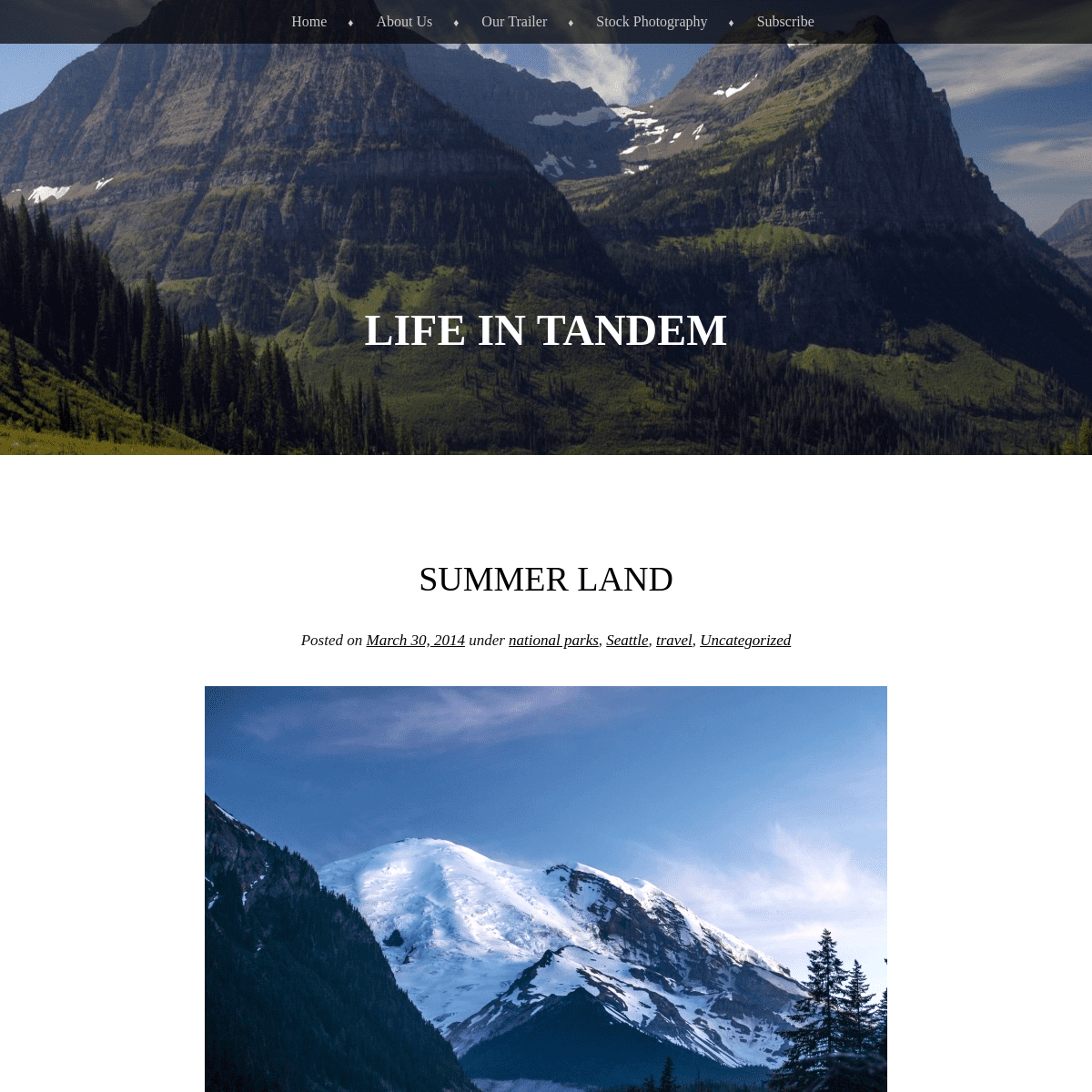
SUMMER LAND
Posted on March 30, 2014by
Kelly + Nick
under
national parks
,
Seattle ,
travel ,
Uncategorized
Mt. Rainier glows as the last rays of sun sink below the horizon While in Mt. Rainier National Park we listened to: _Human_ by Daughter_Mystic_
by
Joshua James
_On the Way Home
_by
John Mayer
You can listen, too, by clicking the links above while you read along. July 4th weekend marks the unofficial start to summer in Seattle. Many years, we’re told, the endlessly sunny days that mark the brief 3-month Pacific Northwest summer hesitate and dawdle their way through May and June, hemming and hawing with rain showers, teasing sun-starved Seattleites with fleeting patches of toasty vitamin D. Somehow, this year, we lucked out. May was unusually warm and clear, giving us ample views of the Olympic Mountains across the Puget Sound to the west and of the Cascades to the east. As we settled into our new house and got used to working our new jobs, we had little time to travel and discover much outside of the city. By the time the 4th came around, we were eager to hit the road again for a long weekend of hiking and campfires on the slopes of the Pacific Northwest’s iconic peak: Mt. Rainier. Full morning sun finally begins to warm the air at Sunrise The Vibe was in the shop getting some small repairs after our long trip, so we decided we’d tent camp and go light for the weekend. We left the city under a mantle of smothering morning fog, headed south and east through the Muckleshoot Reservation (with a brief stop for fireworks) and into the densely forested foothills past Enumclaw, the names of the towns through which we passed rolling off our tongues like poetry. Where we come from, cities and towns and forests and lakes are named after stodgy, long-dead Englishmen or even after other cities and towns and forests and lakes named after stodgy, long-dead Englishmen. The First Nation names of many Washington towns take on an exotic air, stirring in us a mystical excitement, swirling around us like the mist through the stately firs lining the road. According to the map, we were close to “The Mountain,” as Seattleites lovingly refer to Rainier, but the fog had lingered and her broad, glaciated flanks were hidden from view. The road into the National Park meandered south for a few miles before we banked left over a short bridge and began climbing in elevation along the White River, a line of milky glacial runoff bisecting a massive, boulder- and tree-strewn gorge, the aftermath of the torrent unleashed during spring rainstorms. Several miles later and a few thousand feet higher in elevation, we arrived at White River Campground where we picked a site a few yards from the edge of the steep river embankment and set up for a relaxing afternoon of fireside reading and lazy summer naps in the quiet shade of ubiquitous Douglas Firs. As the afternoon wore on and we began to prepare for dinner, the sun finally burned through the fog, revealing The Mountain in all it’s glory, looming above valley cut by the river, draped in brilliant ice, crisscrossed by electric blue crevasses like scars, a rooster-tail of snow streaming from the summit in the southerly wind. We snapped a few photos as the sun set and retired to our fire. Mt. Rainier looms above White River at sunset Our trusty tent sits at the edge of the embankment of White River As darkness fell, our neighbors, absent all day, returned to their campsite, speakers blaring reggaeton music, where they draped a Colombian flag over a clothesline and began hanging what appeared to be, for all intents and purposes, a portable LED disco ball beside it. The driver pumped up the tunes as the other three cracked cans of beer and twisted the tops off of plastic Smirnoff vodka bottles. We had no idea Mt. Rainier could be such a party! The disco ball swayed slightly in the breeze, changing colors every few seconds from magenta to blue to green to yellow, all the most synthetic of tones, bathing the Blue, Red and Golden glory of la Republica de Colombia in unnatural hues. A Park Ranger finally appeared to put a stop to the revelry, but not before a half dozen irate campers took turns storming into their site to demand peace and quiet, libertad y orden. Late season snow clings to some of the higher ridges. Morning sun heats up the eastern slopes of Mt. Rainier above WhiteRiver
The next morning broke crystal clear and we rustled up a few flames on the fire. Soon, with a pot of coffee and a cast iron skillet of sizzling bacon, navy blue skies beckoned us into the thick shade of the pine forest and onto the mountainside. We set off from our site on the fabled Wonderland Trail and immediately crossed the White River on a series of ramshackle wooden bridges, emerging on the far bank before stepping onto the trail into the woods. Kelly pauses above a particularly torrid section of Fryingpan Creek Rainier’s lower ridges appear through breaks in the forest The section of the Wonderland Trail up to Summer Land–a broad, open meadow sprawling across the eastern haunches of Rainier just below Fryingpan and Emmonds glaciers–has three distinct sections. The first meanders through tall firs, cedars and hemlocks along Fryingpan Creek, a narrow chute of white water that carves the rock into a steep channel during its descent from the upper glaciers and snowfields. Throughout this section we were greeted through breaks in the trees by stunning views of the craggy lower ridges leading up to the broader open expanses further up on the mountain. Snowmelt from higher elevations created hundreds of waterfalls, whose constant dull roar was audible throughout almost the entire hike. Kelly crosses Fryingpan Creek Kelly passes through a wildflower meadow The trail eventually leaves the forest, cutting a narrow swath through verdant meadows of wildflowers (though many were not yet in bloom), inviting us on a gentle ascent towards the main upper peak, now completely visible, directly ahead. From there we reentered the forest and began kicking in our boots to gain whatever traction we could as we zigzagged up a series of switchbacks, still buried under several feet of dirty, icy snow. Though we didn’t posthole much, at times we wished we’d brought crampons to mitigate the risk of a rapid, slippery, uninvited descent. The expansive Summer Land meadow stretches up towards Mt. Rainier’speak
Kelly leaves our picnic spot to head back down to our campsite At the top of the switchbacks we emerged, at last, at Summer Land, the alpine meadow crisscrossed by tiny creeks and streams whose frigid waters derived directly from the glaciers hanging just a few hundred feet overhead. Patches of snow still lingered despite temperatures in the 80s. We found a warm, flat rock alongside an idyllic stream and unpacked our lunches, pausing only to admire the view, revel in our solitude (we shared the view with only one other human soul whose profile we could barely make out as he traversed Fryingpan Glacier higher up), and free our burning feet from sweaty boots. I alternated warming my feet on the rock and cooling them in the arctic waters while we downed a few sandwiches. The sky was a pristine blue save for a few wisps of clouds rising up the western side of the summit, condensing briefly on the heated air, then evaporating just as quickly. Everything was green, white or blue, two-thirds a perfect patriotic display. The summit of Mt. Rainier is smothered by Emmonds Glacier, as seenfrom Summer Land
Summer Land is another one of of those places we found where its name so aptly describes its best feature. It’s not a place to be for much of the winter when endless storms batter and bury the meadows, scouring them with bitter winds. While there are many, including myself, who would love to see it covered thick with white fluff beneath a cobalt winter sky, its true glory is revealed during those two brief months when the snows melt enough to unleash rolls of green dappled with a full spectrum of wildflower bouquets. Sitting beside a giant pile of snow on Independence Day in shorts and a t-shirt, just below the behemoth summit we pine after on clear Seattle days, gazing up at the lithe tongue of Emmonds Glacier stretching to Rainier’s peak, it was clear to us that this place was meant for summer dayslike these.
Here are a few more photos from our trip to Mt. Rainier National Park: Our trusty axe takes a break from chopping wood Our tent takes in the crisp morning sunlight A spider perfects his web, hoping for a morning meal The trail to Summer Land finally breaks free of the trees and into awildflower meadow
Kelly hikes up a rough set of stairs in Summer Land Sunrise strikes Mt. Rainier from Sunrise Point A long, slender ridge approaches the summit of Mt. Rainier above WhiteRiver
Thick fog blankets the lower valleys below Sunrise Point The lower ridges of Mt. Rainier extend for miles in every direction Mt. Rainier’s summit catches some of the first rays of sun to hitwestern Washington
The visitor’s center at Sunrise Point begins to thaw after a brisk summer night at 6500 feet Hardy firs brave the chilly onslaught with temperatures often falling below freezing all year long Broccoli and Pork Chops heat up over our campfire Tasty Pork Chops sizzle on the fire grate 46.853704 -121.758950Advertisements
Report this ad
Advertisements
Report this ad Leave a comment THE GIANTS AT THE END OF THE ROAD Posted on March 14, 2014by Kelly + Nick
under
leaving ,
national parks
,
Road Trip
, Seattle
, travel
,
Uncategorized
Kelly wanders between huge trees on the Stout Grove Trail “…you discover that home is not a person or place but a feeling you can’t get back…” -Noah Gundersen, _First Defeat_ While driving and hiking among the giant Redwoods we listened to: _Perth_ and _Beth/Rest_by Bon
Iver
_Codex _ by Radiohead_The Autumn Tree_
by Milo Greene
_Brothers on a Hotel Bed_by
Death Cab for Cutie
Do yourself a favor and click the links above to listen to these songs while reading along! The 101 heaves itself over hill after hill, tawny hued, interspersed with islands of farmland or thickets of low brush and California Oak, arcing up over hilltops and down through the subsequent troughs as aggressively as it pitches itself left and right. The warm weather has accompanied us north from Sonoma and abundant sunshine paints the pastoral landscape, keeping the fog at bay. With our windows down we feel the chill breath of the Pacific, recurrent to our left through breaks in the treed slopes. The road is, at this point, a throwback, just a few lanes wide without the gentler bends and easy grades of an interstate, not swelled by a current of automobiles too great for its design. The streets of the few towns we pass through are lined with cars from an earlier era: old Volkswagen Vanagons and Westies, Volvo station wagons from the 1960s with curvy fenders and rounded hoods, nothing flashy per-se, like muscle cars, but well-kept autos saved from the corroding rust that plagues their east-coast cousins. The Vibe rests beneath some of Humboldt Redwoods State Park’s trees The northernmost counties of California are less conspicuous than their southern counterparts and, at times, are downright rural. Through much of our drive up the California coast we could feel the subtle crush of humanity–perhaps because we had just come from several weeks in the relatively empty mountain west–and even in
wilder places like Big Surand Joshua Tree
, we felt
sandwiched between the behemoth citieslooming
nearby. On the one hand, it’s a testament to the grandeur of the country’s most populous state that there is so much natural wonder easily accessible from huge cities, but on the other hand, the west coast felt, in many ways, as crowded as the east. We were looking forward to reaching Eureka and Arcata, archetypal northern California surf towns lashed by the pounding Pacific and smothered in fog, and the abundant Redwood groves that would begin to fill in the map as we progressed north towards the Oregon border. But our first night on this leg found us at Humboldt Redwoods State park, a half-open campground along a stretch of the highway that pinches down to two lanes between dense forests of massive trees that appear seemingly out of nowhere. The South Fork of the Eel River trickles nearby as we pull off a scenic extension of the 101, the Avenue of the Giants, and find a site at the base of a tree as wide as the Jeep. A wary sleep finds us as a gentle breeze rustling through the trees around us brings to mind a sign we’d read warning of “widowmakers,” or huge Redwood branches, basically trees in their own right, that are shaken loose by the wind and sent plummeting hundreds of feet to theforest floor below.
Orick is a small town with few amenities but lots of charm Early the next morning we pass through Arcata and into Eureka, a busy town with a bit of a vagabond spirit, hosting hitchhikers and surfers and rubber tramps, with a smattering of industry clearly supporting a low-key lifestyle. The Redwood State and National Parks lie in a cluster beginning just a few miles north of Eureka in a sleepy conglomeration of inns and shops called Orick. We’re greeted by a giant plaster Paul Bunyan, axe in hand, attended by Babe, his trusty blue ox, towering 50 feet above a near-empty parking lot and signs for the “Trees of Mystery,” a tourist trap where visitors are educated in the history surrounding the area–and Bunyan’s legendary part in it– via exhibits of chainsaw-carved burl. It’s a kitschy spectacle that warrants little attention, certainly not the gimmicky, played-out kind given it by what seemed like hundreds of billboards advertising its impending arrival. I’d been to the Redwoods once before, remembering not just the corny Bunyan on the roadside, but much more a feeling of awe as I rode beside my friend Jon, on tour with our band, seeing the first of the gigantic trees lining the highway as we made our way south on Route 199 past Jedediah Smith Redwoods State Park. We could only see the stumps illuminated in the headlights, but they were as wide as our tour bus and seemed to crowd the road, jumping out into our path at each bend. I remember the feeling of insignificance when, in the foggy gloom the next day, a semi rig was dwarfed by the huge canopy towering overhead, looking like a toy a truck, my perspective altered. This was Kelly’s first time seeing them in person, however, and I was excited for her to experience the true majesty of the Redwoods. A young bull Elk eyes us from the side of the highway An elk grazes in Elk Prairie near our campsite Past Orick we found our way onto the Newton B. Drury Scenic Parkway, a two-lane road that parallels much of the 101 through the parks before rejoining it just south of Crescent City. The forest cleared into a few expansive meadows where giant herds of elk grazed. Across the fields a wall of greenery shot 300 feet into the sky along the tiny road leading into our home base for the next few days, Prairie Creek Campground. We found a site surrounded by lush ferns and low brush directly on the edge of the serene Prairie Creek. The perpetual wetness of the area, deep greens fueled by incessant fog and rainfall and an all-encompassing forest were not lost on us; we’d reached the Pacific Northwest. We wasted no time starting to explore. There were a number of shorter hikes to magnificent old-growth groves including the Big Tree Wayside and Cathedral Trees (where a short trail takes hikers around a tree so large the original owner of the land thought to cut it down and use the stump as a dance floor) and the Lady Bird Johnson Grove (named after Claudia Alta “Lady Bird” Johnson, former First Lady of the United States) which rambled on a loop through a section of beautiful upland forest. Kelly admires a large Redwood in the Lady Bird Johnson Grove Prairie Creek trickles by our campsite The most impressive hike, however, was the Redwood Creek Trail, a route that brought us down into a river basin and required us to spend much of our day wading up the namesake creek towards the Tall Trees Grove to our north. Shortly after arriving at the river and situating ourselves with water shoes and walking sticks for stability on the five requisite river fords, we looked down at our feet to find a perfectly preserved cougar print in the sandy bank, it’s span nearly the size of my hand. Normally, wading waist-deep in the Redwood Creek would be numbing, but the warm weather continued to follow us north and the 85-degree heat almost unheard of in northern California in early May made the water more than inviting. Moreover, our vantage point from the river provided us an exceptional perspective, one where we could see how tall the trees around us actually were (generally, when in the woods, it’s very difficult to see the tops of the 350-foot trees). We had the trail entirely to ourselves and took advantage of a few deep, cold eddies, swimming off the heat to our hearts’ content. And the Tall Trees Grove at the end of the creek trail held some of the largest trees we’d see in the area. We snapped a few photos of ourselves, tiny against massive trunks and standing chest deep in giant ferns and oversized Redwood Oxalis, then wound our way back up the trail to the Jeep. Kelly emerges from Redwood Creek after one of many fordings Kelly rounds a bend in the trail by a behemoth Redwood in the TallTrees Grove
Most of us have been exposed to the Redwoods while growing up from the Star Wars movies, particularly Return of the Jedi and the two Ewok spinoffs. Filmed in the Redwood parks, Endor–the forest moon– is a place on such a grand scale that it piques our imaginations. Dense fog rolls off the Pacific, thick and low in the summer, thinner and high in the winter, keeping temperatures generally in the 50s and 60s and creating an aura of true mystery. Plying the paths through the many ancient groves, we can see leviathan trunks but never their lush crowns. Some of the trees were saplings in the time of the Roman empire and when Jesus Christ walked the earth–a lifespan that’s basically unfathomable. The few trees we see today, some 5% of the coastal redwood population 150 years ago, are sole survivors of an arboreal slaughter. A majority of the most impressive trees are long gone, probably having been milled into pieces of furniture for some big-city law offices or New York lofts. Standing at the base of one of these marvels, we found it very hard to believe someone could look upon the redwoods and simply see dollar signs. Seeing clearcuts generally depresses me, but standing on a high hilltop looking down at hundred-acre swaths of redwood forest that were leveled in the late 19th century took me to a whole new level. Many, many generations will pass before prolific forests of astounding redwoods grow again like they did before, over the period of just a few decades, mankind brought most of them down–and that’s if we manage to properly protect them for a few millennia more. Nick pauses at the base of a giant Redwood in the Tall Trees Grove Kelly enters the woods at the edge of the Tall Trees Grove Kelly and I decided we’d spend the last few days of our trip a few miles north at Jedediah Smith Redwoods State Park, a particularly well-preserved section of woods sporting the supposed “most massive” tree in the world. Online research doesn’t disclose much detail about the exact location of this tree, but, I read, it was somewhere off the Boy Scout Tree Trail along the Smith River, near the site of much of the filming for the Return of the Jedi Endor scenes. It just so happened that we visited this section of the park on May 4 (May the 4th be with you). We followed a narrow, pothole-pocked road to the Boy Scout Tree Trail where we quickly hiked along the rolling path to its terminus, a picturesque waterfall rushing over a fallen tree into a still, clear pool. The trail was littered with yellow Banana Slugs inching their way across the dusty walkway to damper pastures. On our way back we took a side trip to Boy Scout Tree, one of the most gargantuan trees we’d see in the entire Redwood Park system. No luck on the largest tree in theworld, though.
We ended our Redwood hikes in Stout Grove, an overcrowded lowland forest along the river that provided some of the best photo opportunities. In lowland forests, the understory tends to be less dense, allowing for better views of the trunks of the Redwoods. We dallied around the loop and then headed back to our campsite for an afternoon of lazing along the Smith River. We wanted to take full advantage of the perfectly azure skies and near-90-degree heat. We set our chairs up in the shallows and kicked off our sandals, only looking up from our books long enough to dive into a 15-foot-deep pool of aquamarine water when we got too sweaty. The water was brisk to say the least, but compared to the steamy air it was supremelyrefreshing.
A Banana Slug slinks across the trail A gentle waterfall drops into a tranquil pool at the end of the BoyScout Tree Trail
Kelly and I spent our last few days in a strange sort of limbo. We knew our trip was all but over–our budget didn’t allow us to take any time in Oregon or southern Washington, so we knew as soon as we turned out north onto Rt. 199 and crossed over the border into Oregon, our trip would be over. Campfires would no longer be a nightly guarantee. We’d switch over to sleeping under a roof, using a bathroom with indoor plumbing, having to find work all over again. Our liberation was drawing to an end, but the excitement of a new life in a new place began to set in as a reality as well. Kelly was more vocal about her excitement than I, perhaps because deep down I’m content with being a vagabond. Even the moderate simplicity of our life over the last 10 weeks dug deep into my soul as necessary and beneficial and even the “right way to live.” I loved waking up in a different place every few days, seeing the earth bend lithely over the horizon, waking with the sun, drifting off to sleep with a fire-heated face in a dumpy camp chair. The smell of pine or oaks or juniper and sage through the windows of our camper evoked the sense of cabin living, but the permanence of such living was now at an end. Kelly poses on a knob sticking out from the Boy Scout Tree, one of thelargest we saw
Kelly relaxes on banks of the Smith River The next afternoon we turned out of the last campground we’d stay in, a right onto 199 and up the hill towards Oregon, a lush green paradise to the north (like Vermont on steroids), but didn’t get far before we pulled over at a bridge overlooking the Smith River; one last summery dip in the icy snowmelt before the long slog to Washington was in order. The road curved and bent around hills and river banks, the cobalt sky drifting into roses and tangerines with the setting sun along I-5. Mt. Hood silhouetted in the distance as we neared Portland and pulled over for the night at a rest stop. The next day was clear and bright and the sentinel volcanoes of the Cascades stood at rapt attention to our east, first Hood, then St. Helens and Adams, and finally the crown peak, Rainier. This would be the beauty on our horizon in Seattle, a city ringed by snowy peaks and emerald forests. We unhooked the vibe on a shady street in front of our friends’ house and were greeted by Nate and Amanda, our gracious hosts for our first few weeks in town, and stepped across their threshold, feeling the life we’d lived throughout the spring, our life in tandem, coming to an end… …at least for now… The chilly Smith River provides a perfect respite from unseasonablywarm spring days
Here are a few more photos from the Redwoods: Elk graze at Elk Prairie Redwoods are so large that smaller trees often grow on top of them Almost everything that falls to the ground is quickly swallowed up byground cover plants
Giant, gnarly redwoods and dense understory create a mystical aura Redwood Oxalis is purple on the bottom. One of many exceptional swimming holes we found in the Redwoods Redwood Oxalis blankets the ground between trees Kelly pauses between two giant redwoods along the Boy Scout Tree Trail Dense patches of ferns and Redwood Oxalis line the trail through theTall Trees Grove
Many fallen trees are cut through to keep paths clear Kelly is dwarfed by massive Redwoods, many over 300 feet tall On many trees, branches don’t begin to grow until almost 100 feet upthe trunk
Redwood forests are dominated by lush greenery Often shrouded in thick fog, we were able to photograph the Redwoods lit by filtered sunshine Redwood Oxalis is huge (like everything else in the area), sometimesas big as our hands
Kelly poses by a gargantuan tree at the entrance to Prairie CreekCampground
41.796801 -124.0819681 Comment
GOLDEN GATE, GOLDEN STATE Posted on March 4, 2014by Kelly + Nick
under
leaving ,
Road Trip
, Seattle
, travel
,
Uncategorized
Namesake golden hills blanket the wine region of California While in San Francisco and Sonoma we listened to:_The Stable Song_
by Gregory Alan Isakov_Perfectly Aligned_
by Milo
Greene
_Here it Goes_
by Jimmy Eat World
Click the links provided for an enhanced reading experience! “This tastes terrible!” Adam quipped in his Kiwi accent after taking a gulp from a tall, silver can. “What did you end up buying at the grocery store anyways?” I asked, crossing the dirt road between our campsite and the one occupied by our new Aussie friends, Adam and Emily. “I picked up these Budweiser Clamatos and some Limearitas. I wanted to get what you Americans drink.” I tried to explain to him how terrible a choice he’d made, and should have equated it to going to Australia and drinking Fosters, but instead I simply suggested we take a little road trip. Twenty minutes later we were cruising in the Jeep down the winding road from Sugarloaf Ridge State Park on our way to Petaluma and, later on, Santa Rosa to find the Lagunitas and Russian River breweries, respectively. It was about time I got my hands on some Pliny the Elder anyways and showing Adam good beer was easier (and more enjoyable) than telling him about it. We’d met Adam and Emily on the evening of our first day in San Francisco, or Marin to be exact. We’d pulled up in mid-afternoon to the only reputable trailer park we could find in the Bay Area set just off the shoulder of the 101. It was occupied by a mixture of permanent residents and passers-through like ourselves. Only the haunches of the hills around Sausalito and the Golden Gate Bridge separated us from San Francisco proper and we planned to ferry into town that night, have dinner with our college friend, Annie, and then bike back through Sausalito and over the Golden Gate the next morning to spend a few days at her Russian Hill apartment, which she very generously offered to us even though she was headed to a music festival in Southern California. The Golden Gate Bridge is all that separates us from San Francisco As we locked up the Vibe and began mounting up for the short bike ride to the ferry terminal, a rented RV backed into the vacant spot beside ours, a blonde woman our age guiding her male companion into the slender plot. We gave cursory hellos before pedaling off. The blustery ferry ride took us past Alcatraz Island at sunset, framed by the Golden Gate to the west and shortly we docked at the pier, finding Annie waiting for us at the bottom of the ramp. It was a great opportunity to catch up with her as we hadn’t had the chance to see her in almost a year. She gave us the scoop on good things to do in San Fran and then took off to get a ride to the airport for her flightto LA.
Upon returning to our site later that evening, we found Adam and Emily out enjoying the cool evening beneath their RV awning. I decided to offer them a 5-pack of Smirnoff Ice bottles (leftovers from “icing” Jon Mark in LA ), which prompted an invite to hang out with them for the evening. Emily and Adam are the type of the people who instantly make you feel comfortable. They hold no pretentions, are unfazed by everything, are hilarious and have endless interesting stories. Adam, they informed us, though originally from New Zealand, now runs a logistics company in Australia while Emily writes press releases and articles for the Australian Government. They were on the first week of a 7-month trip across the US, Mexico and Europe, an epic that made our near-3 month journey seem like a quick weekend on the Cape. They’d flown into Vancouver, taken the train to Seattle where they rented an RV, then cruised down through Oregon to San Francisco. We shot the breeze with them until the early morning hours until an irate full-time resident in a bathrobe and with curlers in her hair reminded us that quiet hours were long in effect. Thankfully, Emily and Adam didn’t have plans to leave the RV park until the same day as we did, so we promised to reconvene before we went our separate ways. It was another welcome bit of friendship and we wanted to be sure to exchange information and follow each other on our respective voyages. Biking through Sausalito the next morning was fantastic. The path led us up and down verdant hills with views of the city interspersed and along the fingerlike coves of San Francisco Bay, where we saw the stubby fins and thrashing tails of Dogfish not a yard from the shore. We crossed the Golden Gate Bridge around mid-day and, after meandering along the San Francisco Bay Trail, we found our way to Annie’s apartment and then headed out for an afternoon of sightseeing. We ate decadent milkshakes at Ghirardelli Square, watched a street musician and gave him a few bucks, wandered up to the famous curves of Lombard Street, had a happy hour drink at a bar with a giant Sasquatch looming in the corner, and grabbed Thai food for dinner before calling it a night. The Painted Ladies are famous from Full House We began our Saturday at the Embarcadero Farmer’s Market, a must-see for farmer’s market enthusiasts, wandering aimlessly between stalls selling fresh herbs and greens, roots and every bounty California has to offer. We tasted olive oils and samples of delectable charcuterie and hand-made donuts and finally dragged ourselves away upon realizing how much money we’d spent, tufts of scallion stalks and beet greens sprouting from our overstuffed backpacks. Next up was brunch with two of my second-cousins, Lisa and Gloria. We’d all grown up in the same town in Massachusetts, but they’d moved out to the Bay Area a fews years ago and this was the first time I’d seen them in a while. It was really great catching up and realizing we’d be living on the same coast as them. I think it was also the first time we’d all sat around and talked as adults, which was refreshing. As afternoon fog rolled in, we saddled up again for the start of a 20-mile trip back to our camper in Marin. We dawdled our way through Alamo Square and the Haight, along the northern edge of Golden Gate Park, and turned north through the Presidio back to the Golden Gate. After pedaling directly into a headwind, we emerged in Sausalito and abundant rays of sunshine, the fog dissipating at the northern edge ofthe bridge.
Crossing back over the Golden Gate was a much foggier affair than theprevious day
Back at the RV park, Emily and Adam relayed a setback in their plans: Yosemite was still mostly closed due to snow. They were thinking of heading straight on to Las Vegas before we proposed they accompany us up to Sonoma for a few days of vineyard and brewery tours. Sugarloaf Ridge, our campground destination, would be a much more bucolic backdrop for camping than the paved RV resorts in which they’d been staying and wine country is simply iconic of California. They accepted and we rolled out the next morning. We found the campground almost empty and unpacked our campers under the shade of a few sprawling oaks beside a trickling stream. A few small herds of deer grazed in the fields around us fascinating Adam, who hadn’t seen many wild deer as they aren’t ubiquitous in Australia, and exciting myself, still considering the possibility of photographing a cougar or bobcat predation (no such luck). Deer graze near our campsite at Sugarloaf Ridge State Park Sonoma is beautiful country. California’s moniker, the Golden State, is fully appreciated here as gilded hills run in every direction, mottled green with trees and bushes. The cool, cloudy coastal climate we’d found ourselves in since Los Angeles was replaced by the hot, dry interior climate and we enjoyed sunny skies and temperatures near 90 degrees. It hadn’t been this warm sincewe left West Texas
and the
summery days with wall-to-wall blue skies were welcome. We toured a few wineries including Ravenswood (on a recommendation from a few friends) and even a sparkling wine vineyard where we were treated to delicious bubbly and views straight out of Tuscany, replete with rolling vineyards separated by Poplar-lined dirt roads (the only downside being that we were encouraged to “frame our receipt to show we’d gone somewhere fancy” on our way out–clearly my six-month beard didn’t imbue an air of elegance). A little bubbly in the shade hits the spot on a warm, sunny afternoon For me, however, the breweries were what I’d been waiting for. Lagunitas greeted us with the sounds of live music wafting over the fence from a beer garden drenched in afternoon sunlight and a laid-back, celebratory attitude that complemented their excellent draughts. Of all the breweries in the area, Russian River was the prize on which I’d set my eyes, particularly for their highly sought-after IPA, Pliny the Elder. Many of my Californian friends insisted we stop through Santa Rosa on our way north and the brewery was a mere 15 minutes from our campsite, so we relented. After waiting for over an hour we finally got a table and sampled their taps, everything from double IPAs to sours. While the Pliny wasn’t the best IPA I’d ever had, it sure was tasty, so we filled two growlers and headed back to the campsite. Vineyards stretch in every direction in Sonoma Around the campfire on our last night with Emily and Adam, we basked in new friendship and the dull light of a near-full moon, talking about the differences between the US and Australia, regaling each other with tales of what it’s like where we come from, and sharing our thoughts about life on the road. Our journey was coming to an end and in a week we’d be in Seattle, our new “home,” sleeping under a real roof and thinking about jobs and apartments. Adam and Emily were on the first leg of a mammoth endeavor that would take them to over a dozen countries with many languages, through mountains, deserts, plains, to beaches, villages and giant cities. The better part of the next year of their lives would be lived in constant adventure and exploration. The deer in this area remain alert for predators like Cougars. As we burned through bundle after bundle of firewood, Adam returning to his Clamatos, Kelly and I began to remember what it was like to live life with other people around all the time. We’d been alone, just the two of us, for much of the past 3 months on the road and, while I’ll never complain about spending time with my wife and best friend, including others again in the narrative of our life was becoming more and more enticing. Adam and Emily provided that spark and a bit of companionship for our tour through one of the most enjoyable regions of California. The shriek of a bobcat shook us from our conversation and, after a brief and unsuccessful attempt to find him in the dark with just a couple headlamps, we called it a night and retired to our campers. I awoke the next morning to the gobble of two enormous toms strutting through our campsite just after sunrise, and we said our goodbyes and drove our separate ways, their sights set on the Sierra Nevada and Las Vegas, ours on the behemoth coastal Redwoods to the north. 38.435640 -122.512021 1 CommentNACIMIENTO
Posted on March 2, 2014by
Kelly + Nick
under
leaving ,
national parks
,
Road Trip
, travel
,
Uncategorized
A palm tree hangs over the steep slopes down to the Pacific, framingMcWay Falls
While in Los Angeles and Big Sur we listened to: _1957_ and _Son, My Son_by Milo Greene
_Lonesome Dreams_
by Lord
Huron
We cannot recommend highly enough clicking the links above to listen while you read along, then purchasing both albums and listening tothem on repeat.
It’s a funny thing, especially because I spent the first eighteen years of my life in landlocked Indiana, but I need the ocean. Maybe it’s simply because it reminds me of how big the world is. Even as a little girl I can remember walking along the shore in Florida, the waves washing over my feet, and finding a sense of peace in knowing that were I to float over those many miles of waves I would eventually find myself on another continent full of different people living lives that may not resemble my own at all — except in those most basic and beautiful ways that make us all human. I think being near the ocean reminds me that my troubles exist only in one place and for a moment, that they are not permanent or even insurmountable. It has always been a grounding force in my life. Wildflowers bloom along the beach as the far-off barks of sea lions float up over the bluffs I feel that way, a little bit, around any of the breathtaking backdrops that nature provides – jagged mountain ranges or broad, flat plains that go on so endlessly that you can see the curve of the earth on the horizon. And we had seen plenty of such awe-inspiring places on this amazing trip of ours. But as we neared the ocean driving from Joshua Treeto Los Angeles
one clear blue morning in late April, I could sense my energy rising as we neared the Pacific. This shift in my subconscious mirrored a more concrete shift in our trip – it seemed as though the compass in our Jeep had been reading West (or some variation thereof) for ages, and now suddenly we were going to be pulled northward by the PacificCoast Highway.
LA might not be the most apropos backdrop for a dusty Jeep, giant trailer, and two twenty-somethings (one of which was increasingly big-bearded), but we were ready to embrace city life for a few days. It seemed like the right place to begin the west coast portion of our road trip, especially since we had a very hospitable friend in Pasadena who was willing to let us park our big trailer in front of his house and let us live with him and his housemates while we were in town. Our host, Jon Mark, just so happens to be one of the most fun, easy-going, and all-around-good guys we know, and getting to hang out with him for a few days was a treat. We ate more fish tacos than we could count, caught up with my aunt (an amazing writer and retired professional skydiver), drank beers around a backyard fire with old friends from Massachusetts and new ones from California and everywhere in between, celebrated a stranger’s birthday in a park, and paid the obligatory visit to Venice Beach. But mostly it felt good to be around a community of people again–better than I expected–and I could feel myself beginning to let go of life on the road in exchange for something more permanent, at least for a little while. After a few days living it up in Pasadena it was time to say our goodbyes and head up the coast to one of the places we had been looking forward to since the beginning of our trip: Big Sur. After a night camping out at an impenetrably foggy Pismo Beach, we cruised up the Pacific Coast Highway, past Hearst Castle and towards the looming cliffs just to the north. The Pacific Coast Highway spans many huge gaps with gorgeous arched bridges where the cliffs are too steep to cut the road into As the highway became increasingly twisted and we gained elevation over the cold blue Pacific, hugging the shoreline, the road blasted into walls of rock, I felt as if I was being swallowed by this wild place. Big Sur is magical–the mist of the ocean, waves crashing far below, craggy cliffs wet from sea spray, giant red cedars and Santa Lucia firs reaching into the quiet fog with their long, straight trunks. I couldn’t shake the feeling that we were somewhere sacred, that maybe we weren’t supposed to be there at all–tourists driving through this beautifully ominous landscape in a matter of hours when it should have taken weeks or even months to navigate the impossiblecliffs.
A bashful Elephant Seal shields his face from our camera Many Elephant Seals snuggle As beautiful as Big Sur is, it does come with some less attractive features – for instance, the stench of hundreds of Elephant Seals molting on the beach. Before the road started to climb we passed a refuge where these massive, stinky marine mammals outnumbered humans by at least 10 to 1. Despite the odor and the crowds, we couldn’t resist taking a little stroll down the boardwalk to say our hellos and take some pictures of some of the more charming specimens. We didn’t dally too long since we had heard there was a first-come-first-served campground called Kirk Creek up the road, just barely situated on a grassy bluff before falling a hundred or so feet straight into the rocky ocean. Kelly takes in the bright sunlight during a brief break in the seemingly ever-present fog that blankets Big Sur We didn’t get there early enough to snag a site right on the edge of the cliff, but we did get a good campsite and took some time to lay in the afternoon sun, listening to the waves crash below (taking extra precautions to secure Vibby so that she wouldn’t go rolling over the edge of the cliff in the middle of the night with us tucked in bed). A steep hike down to the shoreline led to a sea otter refuge where you could see them bobbing in the surf, clams on their bellies. Bright orange California Poppies line the Pacific Coast Highwaythroughout Big Sur
The next morning we took the Jeep exploring and noticed a side road disappearing into the thick fog on the hills above. A weathered road sign marked the turnoff for Nacimiento road. We turned onto it and started to ascend, one sharp switchback after another, the precipitous mountainside disappearing into a blanket of mist below as we gained thousands of feet, with no barrier on our right side save for some dewy chaparral, until suddenly we found ourselves in another world entirely. After ascending the coastal face of the Santa Lucia Mountains for what seemed like forever (but was most likely less than five miles) we crested a ridge and the fog broke up in a matter of seconds. We were awash in bright, hot sunlight. The road almost disappeared once or twice but we stayed on her even as she transitioned from pavement to dirt and from two lanes to one. We were rewarded with breathtaking views of golden spires of jubata grass framing the ocean far below and with the sweet smell of just-blossoming lupines. We felt as though we had slipped through some magical curtain to find a Shangri La that would surely be gone were we to return tomorrow. Lupines and tall grasses stretch across the perfect field for a picniclunch
We passed a sign announcing the start of Los padres National Forest and drove on, the road to ourselves save for a rickety old trailer parked on what served as a shoulder, a sun-tanned elderly man perched outside in an old plastic chair like a statue. He looked less like a vacationer and more like a permanent fixture, someone who’d left it all behind never to look back. A little later we found a meadow where we decided to pull over to have a picnic in a field of lupines dotted with gnarly oaks, and once we were good and hot we went for a walk in the shade and – wouldn’t you know it! – found the perfect mountain swimming hole to rejuvenate our sun-sleepy bodies. We were joined by two happy salamanders, about a foot in length each, who seemed to be as pleased as we were with what the day had brought. Our swimming hole! Icy cold and crystal clear We shared it with two of these foot-long amphibians. Not sure if they were California Giant Salamanders or Coastal Range Newts After a few hours, mostly out of a sense of obligation, we left our sunny hideaway to see more of what Big Sur had hidden in its pockets of coastline. We drove north and pulled over on one of the many scenic lookouts along the way where we began chatting with another couple on a road trip. Lucky for us, they had just spotted a whale about one hundred feet off of the shore below us. We stood there in silence, just the four of us on the side of the road, as it came up for air and re-submerged, surfacing again to blast a powerful spray of water outof its blowhole.
A rock juts out into the cerulean waters of the Pacific in the SeaOtter Marine Refuge
An hour or two later we found ourselves doing some light hiking at Julia Pfeiffer Burns State Park, a beautiful old homestead-turned-hollywood-resort with a curious history overlooking the picturesque McWay Falls. Originally a ranch in the late 1800s, this little plot of land with million dollar views had been purchased by a wealthy couple from New York who had fallen in love with Big Sur. They planted palm trees and terraced the yard, hosted glamourous parties with Hollywood’s elite, and then placed it in a trust for public use when they passed away. All that was left of the posh mansion was a stone foundation and the remnants of some expensive landscaping, but the beautiful views remained. McWay Falls drops directly into the Pacific We got back to our campsite as the sun set over the Pacific and started to make dinner when the first of several unexpected guests arrived. The wildlife in Big Sur, while abundant, is generally harmless, and the raccoons that were making the rounds in our campground were no exception. The brazen little beasts came right up to our campfire, as if we had been saving them a seat all along. We shooed them off but soon heard a similar commotion at a neighboring campsite, and so on, up and down the hill, until they made their way back to us again. When we woke up the next morning, we laughed at the tiny little black handprints that covered our campsite. Clearly the little critters had been digging through our campfire soot before crawling over every conceivable surface – the table, our chairs, the cooler, the Jeep, you name it. The raccoons may have been annoying, but we couldn’t blame them for trying to score an easy meal off of the dozen or so campers who called Kirk Creek home each night. On our sunny trip north from Kirk Creek, we found many great lookouts The Pacific Coast Highway continues north towards Monterey We were treated to a rare sunny morning in Big Sur and packed up camp, sad that we couldn’t stay longer in this land of sea and stone. Our compass was pointing north as we made our way up the winding shoreline, stopping for lunch in Monterey before rolling on to SanFrancisco.
Here are a few more photos from Big Sur: A few oaks shade our picnic spot Hundreds of smelly Elephant Seals laze on the beach while sheddingtheir winter coats
They often roll or climb over other sleeping neighbors, grunting andbiting
Eventually the Santa Lucia Range flattens out and meadows run into theocean
35.989865 -121.495506 3 CommentsIN GOD’S COUNTRY
Posted on February 27, 2014by Kelly + Nick
under
leaving ,
national parks
,
Road Trip
, travel
,
Uncategorized
A “forest” of Joshua Trees stretches out across the valley floor _“So be sure when you step._ _ Step with care and great tact_ _ and remember that life’s _ _A great balancing act._ _ Just never forget to be dexterous and deft.__ And never mix up_
_ your right foot with your left.”_ _-Dr. Seuss, “_Oh, the Places You’ll Go” While in Joshua Tree National Park we listened to: _Love Like a Sunset_by
Phoenix
_Pirate Blues
_by As
Cities Burn
_Losing You to You _byHammock
Feel free to click the links above to listen while you read along. An old white Lincoln sits beside one of the few occupied buildingsnear Roy’s
Roy’s Motel and the adjacent gas station look like a scene out of No Country For Old Men. A white Lincoln sits at rest next to a building with white washed walls and roof and, besides the exorbitantly priced fueling station and the shack of a Post Office, everything looks as if it’s closed and has been for years. A neat row of bone-white huts line historic Route 66, reminiscent of a shell town built just for nuclear testing, sitting below a busted, rusty neon sign advertising perpetual vacancy. Except for diesel listed at $5.21 per gallon, this section of Route 66 actually evokes the golden age of road travel with clean, ready motels a day’s drive away, friendly, full-service filling stations, fluorescent letters lighting up the black western sky. Our trailer is a blinding anachronism amidst such a movie-setlooking town.
Small cottages line Route 66 at Roy’s Motel & Cafe The Mojave Desert is familiar, but not because we’d spent any amount of time there. Kelly had never been and I’d slept on the floor of a tour bus while some of my band mates drove through Palm Springs in the middle of the night on our way from Los Angeles to Phoenix. I only remember it alternating very hot and very cold as the September night air poured into the open windows, stirring a constant breeze around my face. But we’d seen the Mojave in movies dozens of times, grainy and washed out on film, always dusty and brown with too much midday sun bleaching out white and tan and aqua landmarks. Every time we see it in cinema it looks worn, almost apocalyptic, certainly forgotten. A Joshua Tree “forest” We found ourselves on straight, flat highways again after steadily creeping towards sea level out of Flagstaff. The Ponderosa Pine, Pinyon and Juniper of the Great Basin were long behind us and the cactus and sage of the Sonoran Desert slowly faded out in favor of Yucca, occasional palms and Joshua Trees. The flora had become more grotesque, branches like fingers with rigor mortis, tangled and twisted unnaturally. We expected heat as we came down in elevation; the landscape looked downright parched, but with the windows cracked, a chilly breeze swirled through our Jeep. Rows of mountains seemed to linger on the horizon, never really getting closer, but marking, like a fence, where Death Valley begins to the north. When planning our trip, I, ever the ambitious (read: unrealistic) one, attempted to devise a plan to enjoy the best parts of both the coast and the Sierra Nevada of California. There were five more national parks along the inland mountain route, the tallest peak in the lower-48 (Mt. Whitney), the lowest point in the lower-48 (Badwater Basin), Tahoe, Yosemite, Giant Sequoias, and more skiing. We really didn’t have the money to hop-scotch back and forth and I eventually relented to the coastal route (Kelly’s preferred option). It left Death Valley tantalizingly close as we barreled down I-40 into Southern California. A very rare vintage Airstream Motorhome greeted us in the visitor’scenter parking lot
It was relieving to angle off the interstate just past the California border onto Route 66. We’d done a great job mostly avoiding interstates since El Paso and we felt much more at ease on a two-lane state road than the hulking 4- or 6-lane thruways. At Roy’s we stopped for a token gallon of gas at the vintage pumps and for a Mexican Coke in a glass bottle. It felt like the right thing to be drinking at the time. Only a few bikers on Harleys joined us on our brief respite under the peeling canopy and we soon found ourselves on our way again, leaving Route 66 for the smaller Amboy Road that split two arid farms and angled us south towards an opening in a tawny mountain range and Joshua Tree National Park. One of the main roads through the park features geological wonders and thousands of Joshua Trees Twentynine Palms is exactly what you’d expect in a small desert town–it wasn’t flashy but it didn’t lack any amenity we needed. We found a serviceable grocery store and a post office in which to buy stamps and mail out postcards. A package store stocked California beers, a welcome change after our three weeks in Utah, and the information center for the National Park sported a very west-coast look: low and angular, lots of windows, adobe walls and tile roof, and the mountains of the park all around. We caught sight of an extremely rare Airstream motorhome in the parking lot before filling up on water and making our way into the park and our site at JumboRocks campground.
Vibby arrives at Jumbo Rocks Campground Our campsite was nestled among piles of boulders in Jumbo RockCampground
Despite it being the week between the two Coachella weekends, the campground was generally empty when we arrive and we found our way to a secluded spot with a huge pile of boulders adjacent which we could scramble up for sunset views. A low hill blocked other campsites from our view and bushes separated us from the road. We set up and made plans to explore. A curious warning in the park newspaper caught our attention: aggressive bees. Kelly is allergic and swells up like a grapefruit (a very irritated grapefruit) when stung, so we took this caution seriously. The paper warned us of honeybees’ uncanny ability to sense water in such an arid environment and advised against leaving any water sources open outside. We nervously glanced at a small puddle where our trailer’s fresh water tank overflow had splashed a few drops on the ground when we parked, and then at our Nalgenes on the table, and quickly put anything remotely wet into the camper. A small spill on the picnic table at breakfast the next day would confirm the gravity of the warning as a half-dozen aggressive bees converged on the wet spot and defended it staunchly. A familiar sight: our camp setup with chairs around the fire ring Our first hike took us up Ryan Mountain, the tallest point in the park at 5,457 feet. The trail was a winding affair, though barely steep at any point, and brought us into close contact with a few whimsical Joshua Trees and (my favorite) Cholla Cactus. The namesake Joshua Tree, christened by Mormon settlers who thought the trees’ branches conjured ancient Israel’s Joshua, arms outstretched in battle, is a strange plant. Part of the Yucca family, it’s extremely hardy. Much of the park consists of forests of these trees, though they tend to be so spread out, it’s a strange looking forest indeed. There seems to be no rhyme or reason as to why the branches grow out the way they do from their stubby trunks. Some consist of a few serpentine tendrils reaching out at odd angles, while others resemble Medusa’s head, a tangle of malevolent snakes. Undoubtedly, their odd demeanor served as an inspiration for some of Dr. Seuss’ drawings in many of his children’s books, as he was known to frequent Joshua Tree National Park as an escape from his San Diegohome.
Some Joshua Trees buck the chaotic trend and stand as a simple, tall,straight stalk
Joshua Trees, Yucca Plants and Cholla Cactus line the trail up to RyanMountain
The Cholla Cactus, on the other hand, resembles a bundle of pipe cleaners, much like an elementary school art project. They’re mainly shorter than five feet tall, and their silvery, translucent spines filter sunlight creating a halo-like effect around the top of the plant. In places like the Cholla Cactus Garden where they grow densely, their luminescence, contrasted against a deep blue, sky isstriking.
Two Cholla Cacti glow in the morning sun A Cholla Cactus in the Cholla Cactus Garden We found ourselves at the top of a blustery Ryan Mountain where we sheltered behind a rock and attempted to warm in the sun and have a picnic lunch before turning back down, scoffing at the chilly desert wind that we thought should have been much warmer. In fact, we didn’t see temperatures much above 60 degrees throughout our stay inJoshua Tree.
Kelly reaches the chilly summit of Ryan Mountain, the highest point inthe park
Joshua Tree is a rock climber’s paradise. Throughout our time there we constantly saw people training on the endless slabs of grippy boulders and cliffs. Even climbing rescue teams were drilling in the area, learning on some of the best terrain how to save climbers who found themselves in trouble. Unfortunately, we aren’t adept climbers and didn’t take much advantage of these great features except for a few scrambles near our campsite to get a better view of the day’s end over the desert. The park doesn’t lack a lot of great, very accessible short hikes, however, so we spent much of our second day skipping around the park to find hidden valleys, tranquil rings of rock filled with desert oases, fantastic geology like at White Tank, great lookouts like at Keys View, and even some history at the Lost Horse Mine. Stone features like this provide exceptional rock climbingopportunites
The boulders adjacent to our campsite provided a perfect perch from which to watch the sun set Mining was a major part of California’s history, and Lost Horse Mine is a relic. Unfortunately, high chain-link fences, presumably installed for safety and to prevent vandalism, eliminate the possibility of making good photographs, but being able to see 19th century mining equipment in such a remote area is exciting for history nerds. The story of Lost Horse Mine, which includes cattle rustlers, swindlers and good old-fashioned ingenuity, can be read here.
A cluster of Joshua Trees sits beside the trail to Lost Horse Mine A mature Joshua Tree stands next to a single shoot along the trail toLost Horse Mine
One of the most interesting parts of Joshua Tree, to me, is the oases. Growing up we hear stories of desert travelers seeing legendary oases with cool, clear water bubbling up from life-saving springs, only to stumble forward and discover they were merely mirages. They have a sort of mythical connotation, and while nothing like the oft-romanticized, lush Saharan sanctuaries exist in Joshua Tree, there are distinctly wetter pockets throughout the park where palms tower over shady groves. We were most impressed by Fortynine Palms Oasis on the northeast side of the park. A short hike from the trailhead brought us to a verdant gully on a mountainside where we found shade beneath shaggy, shedding fan palms and a few small pools. Gambel’s Quail scurried between the rocks and underbrush, signaling to each other with a comical, goofy call. Here, the late afternoon California light fell golden across the mountainside and a light breeze shushed through the deadfall from the palms above. We’d made it to the west coast and only a few more hours of driving separated us from the Pacific. The Fortynine Palms Oasis sits in a gully on the northeastern side of Joshua Tree National Park Fan Palms find afternoon shade at the Fortynine Palms Oasis After winding back down the road to our campsite we clambered up onto our little boulder lookout and watched the sun, like a giant mandarin orange, melt on the horizon, painting the desert in shades of blue as shadows filled in. Looking down, we took in the scene of our lives for the past 2 months, our trusty Jeep and trailer, dusty camp chairs by a fire ring, my ax and a bundle of wood, our bikes propped lazily on a boulder. As we scampered back down and began preparing dinner, a visitor popped his head around the corner of the camper and inquired about our Massachusetts plates. He was from the north shore of Boston and he and his girlfriend, a Pennsylvanian, were on a short trip out west. We got to talking and, inspired by Chris and Laura’s generosity , offered them dinner and a spot around our fire. They were both endearing, wandering the desert for a week or two to try and find some variety in life, and had found themselves a few spots away from us with nothing but a can of beans for dinner, but no can opener, so our offer was a welcome relief. We gabbed on for a while about places we knew in common back in the northeast before we got dozy and went ourseparate ways.
The view from the top of the pile of rocks by our campsite reveals our neighbors and a lone climber enjoying the afternoon It was our last night for a little while in the middle of nowhere, one we were happy to share in good conversation underneath a thick tangle of stars with the warm glow of dying embers on our faces, before we would reenter the urban world for the first time since we passedthrough Santa Fe
back in March. Long after the sun had set, a faint glow still percolated on the peaks to the east: Los Angeles was on the horizon. A satellite inches its way across the night sky over our campsite Here are some more photos from our trip to Joshua Tree National Park: One of many great rock climbing lines in the parkA Joshua Tree
The green tufts of leaves at the end of the Joshua Trees’ branches contrast nicely with the blue sky in the desert This exceptionally tangled Joshua Tree caught my eye A large Joshua Tree stands by the side of one of the park’s mainroads
A stone monolith juts out of the desert floor Joshua Trees grow sporadically across the valley floor Boulders scatter the landscape around our campsite in Jumbo RocksCampground
Cholla Cactus in front of a beautiful desert blue sky a Cholla Cactus is resembles pipe cleaners Cholla Cacti grow in thickets in the Cholla Cactus Garden A trail leads through the cool, shady cover of Cottonwood SpringsOasis
Fan Palms and Cottonwoods provide a lush, green hue to the Mojave atCottonwood Springs
A fan palm shows off its deadfall near Cottonwood Springs An older Joshua Tree sports many serpentine branches Joshua Trees of all shapes and sizes dot the landscape near White Tank 33.873399 -115.901063 3 CommentsBOMBS OVER BOYLSTON
Posted on February 21, 2014by Kelly + Nick
under
leaving ,
national parks
,
Road Trip
, travel
,
Uncategorized
While in Page, Arizona and the Grand Canyon, we listened to:_Compass_ by Jamie
Liddell
_Big Iron_ by MartyRobbins
_Ring of Fire_ by JohnnyCash
Feel free to click the links above to listen while you read. Kelly poses at the edge of the South Rim of the Grand Canyon A text message from my brother buzzed my phone in my pocket. “Have you seen what’s going on at the Marathon? Two explosions atthe finish line.”
Cell service was spotty at our campsite but abundant at the visitor’s center where we’d just pulled in, hoping to get information on a good hike or two. His message was about a half-hour old when it finally came through. My initial reaction wasn’t one of serious alarm–I’d worked at the Prudential Center for a couple of years before we left to move out west and there were a few occasions where a sewer would explode from a buildup of flammable gases, sending a manhole cover or two across the street. People were rarely hurt and I’d even heard and felt the rumble from the blasts a couple times from inside my cubicle. I clicked over to Boston.com where little information had yet to be posted, then switched over to Facebook to see if any of our many friends in attendance had posted anything of interest. It was flooded with concerned messages, friends calling for anyone in attendance to sound off and let us know they were ok, other friends of ours who had run the marathon posting to let us know they’d crossed the finish line already and were gone from Copley Square when two pressure cookers demolished the block and sent spectators fleeing in terror. One friend had posted a picture from their prime viewing spot at the corner of Boylston St. and Ring Rd., only a few yards from the spot of the second explosion. We waited anxiously for her, or one of the three other dear friends of ours who were with her, to respond to a text or post that they were, in fact, alive and unhurt. We sat in that Grand Canyon Visitor’s Center parking lot for hours that afternoon, glued to our phones, waiting, watching real-time updates on the marathon’s blog, hoping for good news, holding our breath each time the name of a casualty was announced, sighing heavily, relieved when it was an unfamiliar name, but then guilty at our relief, recognizing that, just as easily, we could have known that person, could have passed by them on the street. It was a surreal experience so unlike the surreal experience we’d had the prior afternoon in one of the most magnificent natural wonders we’ve everseen.
Entering Lower Antelope Canyon–from the surface it’s hardly noticeable in many places. Kelly waits for the tour to begin When we finally left Zion and crossed the border into Arizona, we’d been in Utah for three weeks. We were hoping to make a pit stop at Lower Antelope Canyon in Page, Arizona, near the southern end of Lake Powell, then continue south around the Grand Canyon and spend a quick day there, mostly so we could say we’d seen it. We were wary of the notorious crowds and disappointed the North Rim wasn’t yet open for the season, but figured a day in one of the less-developed campgrounds couldn’t be that bad. We could take a couple shorter hikes down below the rim to get a feel for how big the canyon really is and be back on our way to California by the next day. Everything about Lower Antelope Canyon from the surface is nondescript. A quick drive from Page brings you onto Navajo Nation land where a couple more turns leave you in a dusty, unpaved parking lot with a white shack at the other end. It was reminiscent of a seafood or hot dog stand at the beach in New England, some picnic tables scattered helter-skelter under a rickety awning to block out the sun. We paid our fee and waited under the awning for the next tour to start while about a dozen more visitors queued up, mostly Chinese tourists. When it was finally time to enter the canyon, we approached a narrow, black crack in the dusty rock next to the entry shack and ducked as we stepped down onto a steel staircase. The stairs led us down about thirty feet into a hidden cavern, no more than ten feet wide. It was cool on the slot canyon floor, the sun merely a filtered glow passing down along thousands of striations in the walls around us. The canyon is shallower at the entrance allowing beams of sun to hit the sandy floor, creating tunnels of dusty light In many places the striations in the rock resemble tree rings For a photographer, Lower Antelope is a luminescent dream. There is incredible nuance in the way the diffuse light plays in highlights and shadows on the rock walls, painting the same sandstone thousands of different shades and hues. While many areas are mainly orange and rust-colored, sometimes we would turn a corner to find a tiny chamber of rosy pink or a ledge of deep violet, like an eggplant. Where the canyon opened a little more above our heads, spears of gilded sunlight shot to the sandy floor, lighting the dusty shafts of air like waterfalls. Each tiny crack and fissure was embossed, outlined in deep black shadow. Kelly and I found ourselves lagging at each new chamber, waiting for the group to travel on ahead so we could have our photo-ops to ourselves. Kelly pauses to take a photo of the sandstone walls of Lower AntelopeCanyon
Cool purple shades are a welcome relief from the bright oranges thatdominate the canyon
The tour guide, a young woman no more than 18 years old in jeans and a t-shirt, called out tips on ISO settings to maximize the breadth of rich texture and color in the canyon walls and led the way through the labyrinthine canyon, providing us some historical context for the canyon and the area in general. The most interesting, and perhaps most pressing, bit of history was brought up when a visitor asked about the metal boxes placed at even intervals along the length of the canyon, visible as we stepped down the first metal staircase. They were rope ladders, we were told. In 1997, twelve hikers in the canyon were swept downstream by a flash flood and only their guide survived. They had no warning–sunny skies overhead masked a thundershower miles up-canyon that unleashed the juggernaut surge. These ladders were meant to prevent another such catastrophe, providing a reliable escape for hikers along the entire route in the event of a deluge upstream. Indeed, when in the canyon, we could see that the walls themselves had taken on the shape of millennia of rushing torrents, waves of dusty rock. Thankfully, the spring sky stayed blue for us and we crept our way back up to the surface an hour later, blinking into the blinding sun. The deeper the canyon became, the richer the contrast in color andshadow
Sitting at the South Rim of the Grand Canyon the next day, we finally received word that our four friends had made it home safely, though obviously shocked, one without shoes, and all four grateful to be in one piece. The following week of standoffs, manhunts, gun battles and terror in the streets of our city, our very neighborhoods, would come in brief snippets, news reports on our phones, Facebook posts from friends and family, texts from loved ones letting us know they were ok, though locked down. It wouldn’t be until we reached Los Angeles the following Friday night that we’d feel closure watching a bloodied Dzhokhar Tsarnaev handcuffed on a grassy Watertown lawn next to someone’s boat, just a mile from the house of my best friend. Being on the road for such a traumatic, defining moment in the history of our city was difficult, though we know not nearly as difficult or frightening as it was for our friends and family who lived it, locked in their apartments, hearing midnight gunfire and explosions. On one hand, we could very easily have gone to the marathon this year, a ritual we’ve kept pretty consistently from our days at Boston College. We could have been at our old apartment in Brighton down the road from where a man was carjacked and a shootout with police left one of the bombers dead. We could have been holed up with friends, scared of what was outside the door but at least together with them, knowing they were safe. But here we were, almost 3,000 miles from home on a gorgeous April day at the lip of one of the greatest natural wonders known to man, hundreds of hikers and families and elderly tourists with knee high socks and floppy brimmed hats, kitsch in tow, sunscreen lathered on thick, milling by our car, each of them oblivious to chaos and madness plaguing the city and the people we loved. It was a strange feeling of detachment, like we were experiencing it vicariously rather than first hand and so not really experiencing it at all. And we felt guilty, as if we should be involved in that hellish scenario ourselves, as if we shouldn’t have ever left, that maybe if we hadn’t left none of this would have happened. And we felt strange knowing that it was something we’d never fully share with so many people so close to us. It was something that happened without us in our home, a new altered reality we wouldn’t be going back to any time soon. Boston was a different place than we’d left it and the weight of our decision to leave became acute; the city would not wait for us and stay the same until we returned. We knew our friends would go on living after we left, that they’d get new jobs or fall in love and get engaged, that our niece and nephew would keep growing up, that our aunts and uncles and mothers and fathers would get older. But we never imagined so much change would happen so soon after we departed and all at once. A bit of solace and solidarity would come to us over the next few weeks as we came across other people from Massachusetts and New England, also traveling, also having missed all of the terrible events. We’d ask them if everyone they knew was ok, they’d ask us the same, and we’d stand in awkward silence, sharing feelings and sameness wecouldn’t express.
Grandview Point from the trail As the afternoon wore on, we had to face the fact that there was nothing more we could do. Our friends and family were accounted for, no new information was being released when we refreshed the news sites and we were only making ourselves crazy sitting in the Jeep, worrying. We decided we had time for one quick hike, one that would at least take us below the rim and hopefully restore a bit of tranquility to our troubled minds. We dipped beneath the crusty lip of the canyon and followed a mule path a few miles to Grandview Point. There, we sat on a boulder in the blustery afternoon as puffy white clouds skipped across the deepening sky and gazed out across the massive rift in the desert, pining for a chance to come back and make the full trek to the Colorado River deep in the canyon below, so far down it was out of sight. We finally exhaled and took in the beauty as the late-day light washed over us and warmed our backs, lighting up the cliffs around us in brilliant gold hues, offering a bit of grace for ourweary hearts.
_Here are a few more photos from Lower Antelope Canyon and the GrandCanyon:_
A view up to the South Rim of the Grand Canyon from Grandview Point Part of the North Rim of the Grand Canyon Blinding Arizona sunlight hits us as we exit Lower Antelope Canyon Looking up through the canyon opening into the vivid sunlight Patterns mark the walls in many places The bright orange sandstone glowed a rosier hue the further we delved away from direct sunlight The twists and turns of the canyon kept its mercurial character a mystery until we rounded each bend In some places, the canyon narrows to a slim opening where we had to slide through sideways The sandstone walls resemble the movement of water, the primary forcethat shapes them
The walls move in waves Deep shadows denote the millennia of growth of layer upon layer ofsand
Kelly pauses for another photo Brighter orange hues dominate the canyon near its entrance The canyon takes on bizarre shapes, writhing from top to bottom A narrower section of canyon requires us to squeeze through Light at the end of the tunnel 36.861897 -111.374438 2 CommentsTHE PROMISED LAND
Posted on February 17, 2014by Kelly + Nick
under
leaving ,
national parks
,
Road Trip
, Seattle
, travel
,
Uncategorized
The Virgin River continues its relentless push south towards theWatchman
While in Zion National Park we listened to: _Down in the Valley_ by The Head and the Heart _At the Bird’s Foot_ byCity and Colour
_Heartbeats_ by JoseGonzalez
The only other idiot I came across attempting the Narrows in the spring without a drysuit was wearing a New England Patriots hat. It made sense; 42 degree water is what we expect when beach season begins in Massachusetts. We rejoice when the Atlantic briefly breaks 65 come fall. This fellow was headed back downstream to his waiting wife, who I would later find out, relayed her nervous fears incessantly to Kelly as she awaited my return. The trail up the Narrows is no trail at all, but a simple wading traverse of the frigid Virgin River. Guide services recommend renting a drysuit and a walking stick for the trip. Guides also charge a lot of money for a drysuit and walking stick, and my general life-outlook of, “how bad can it really be?” presided. Kelly didn’t make it past the first crossing as the river’s numbing current sent cramps shooting up her legs. She turned back about halfway across and promised to wait for me, assuring me I should feel free to explore the slender canyon to myheart’s content.
The Virgin River runs cold through Zion Canyon The cramping in my own legs dissipated after the second crossing through the thigh deep water. At this point in the season, the trail featured a series of sandbanks divided by the winding river. It required a series of fordings along slippery river stones. The view was spectacular, like a close-cropped adventure scene from an action movie like Temple of Doom, the only sliver of sky visible directly overhead with the occasional white-blazed wings of rare California Condors dipping across the open crack of blue. I’d left my phone, wallet, camera, and any other non-waterproof belongings at the trailhead with Kelly and worked my way up the fissure, past the crowd of tourists taking pictures of us few hikers, and around the bend into total isolation. I had no plan for how far to go. I was simply going to gauge the sunlight on the canyon walls above and decide what a reasonable turnaround time would be. I found myself dumbstruck by the slim columns of falling water, runoff from the higher cliffs, emptying into the Virgin, contributing to its icy flow. The comparative coolness of the river canyon was a welcome relief from the searing sun, already brutally hot and dry in April on the valley floor. While I would have loved to continue up to one of the remote backcountry sites nestled deep within the secluded crevasse, I eventually relented and made my way back to the gradually-thinning crowd of spectators at the trailhead. Kelly was waiting for me, her feet sufficiently warmed and dried. Zion Canyon opens into a broad meadow near our campground at the southend of the park
Kelly’s parents told us that Zion was a wonderland, one of the most magnificent places they’d encountered in their travels across the country. It’s not that we didn’t believe them, but it’s difficult to grasp how amazing and unique a landscape it actually is. It makes sense that Mormon settlers considered it Zion, a place of refuge from the harsh desert they’d traveled before reaching this relatively verdant, protected valley. The Virgin River runs milky brown through the entire canyon, tame for the time being, but betraying signs of its violent descent during flood season. Its footprint is marked by boulders and cottonwoods tossed and scattered haphazardly along the banks, in many places high above the languid spring current. Live Cottonwoods line the banks as well, their vivid spring-green leaves flickering in the breeze, evidence of the life-giving power of the river. The Watchman as seen from the South Campground We were content to get a good, shaded spot along a tiny creek in the main South Campground, close to shuttle bus service and with great views of the iconic Watchman, a sentinel peak guarding the southern (and only naturally accessible, non-river) entrance to the canyon. We were also reveling in warmer temperatures, with highs reaching the 70s and skies as blue as sapphires. We’d dropped in elevation on the trip since Bryce and the climate reflected it. Our original plan had been to spend only three days in Zion in order to make time for the Grand Canyon before our final push into California. It quickly became apparent, however, that Zion is not a place to be rushed and cannot be experienced hastily; the impressive extent of attractions and stunning features necessitates a longer a stay. The view looking west from the Canyon Overlook Trail is stunning We entered the park from the northeast, meaning we passed through an impressive engineering marvel: the famed tunnel on the Zion-Mount Carmel Highway. The tunnel was dedicated in 1930 and provides direct access to Zion Canyon when coming from Bryce, but it clearly reflects the traffic needs of the era in which it was built. Due to an increase in accidents, particularly “topping out” due to the inability of large vehicles to navigate turns while staying in their lane in an arched tunnel, the Park Service now requires that vehicles over a certain height and width obtain a permit for one-way passage in and out of the park. This means traffic in the opposite direction is completely stopped to allow large vehicles to pass through. Even though our camper was almost two feet shorter than the restricted height and almost a foot narrower than the restricted width, the ranger at the gate insisted we buy an $18 pass and wait our turn to cross into the valley. In spite of the added cost, it did relieve a significant amount of stress as I was able to straddle the double yellow line the entire length of the tunnel and enjoy extra clearance. We safely found our way along the smooth red roads of Zion to our campsite and set Vibby up for our stay. Bridge Mountain towers 6,000 feet above the Virgin River by the SouthCampground
I found throughout our trip that some of the most helpful people in our national parks are, in fact, volunteers. I met one such volunteer, an elderly gentleman whose name escapes me, whose intimate knowledge of the best aspects of the park, coupled with his enthusiasm for helping others share in his love those aspects, set us up for an exceptional, diverse and rich Zion experience. He spoke of Angel’s Landing, a _very_ popular trail that comes with significant risks and challenges (including death), Hidden Canyon, which was still recovering from monsoon flood damage, the Narrows trail up the Virgin River, and the seldom-visited northern section of the park. We were all ears and couldn’t wait to get our feet wet, in some cases literally, exploring. When imagining Zion it helps to know how perfectly named many of the features are. Early Mormon settlers who determined current nomenclature for the myriad peaks, rivers, cliffs, etc., didn’t lack imagination. Many peaks were named after biblical characters, patriarchs from the Mormon faith, or other equally religious concepts. The four peaks that comprise the Patriarchs, a very popular viewpoint visible from the main road into the canyon, are named after Abraham, Isaac, Jacob, and Moroni, not surprisingly the most prominent peak. The Great White Throne rises thousands of feet from the valley floor, evoking apocalyptic images of the throne of God, while the sheer walls of the Altar of Sacrifice are stained red by iron deposits, conjuring the exact image that naturally comes to mind when hearing “Altar of Sacrifice.” Deertrap Rim is named after a practice of early, prehistoric settlers of chasing deer off the rim of a precipitous cliff onto the valley floor below, killing them, albeit messily, for use as food. Such names lend an air of holiness to the region, a sense that they are perilous, brooding, inaccessible places steeped in mystery and death and purity. Mineral deposits run hundreds of feet down the Streaked Wall creating an eerie effect similar to that found on the Altar of Sacrifice Perhaps the most creatively named landmark, and one that is well-trod, is Angel’s Landing, so named because early Mormon settlers couldn’t imagine any other purpose for the dizzyingly vertical, lofty spine of rock jutting into the valley, than as a landing strip for angels visiting the earth from their heavenly realms. An ominous sign at the trailhead indicates just how hazardous the path ahead can be, informing us that a person has fallen to their death almost once each year since 2006. It’s difficult to understand how this is possible for the first couple miles of trail as the only obstacle to overcome is the zigzag of quad-burning switchbacks that get increasingly tighter and steeper as you near the vertical cliffs ahead. Now, anyone who has hiked with me knows I’m a masochist–I put my head down and barrel headlong up the mountain, anticipating extraordinary views from the top, but focusing on nothing less than my next footstep on the trek to the summit. This is a moderate frustration of Kelly’s, but one to which she’s adapted well in our nearly four years of marriage. This was the first hike in which another hiker quipped, “slow down buddy, you’re making us all look bad.” Undoubtedly Kelly rolled her eyes and kept suffering to keep pace. She knows I don’t need encouragement. Angel’s Landing is nothing but a narrow fin of rock stretching into the middle of Zion Canyon Kelly uses guide chains to make sure she doesn’t lose balance on one of the more perilous sections of the Angel’s Landing Trail Progress stopped further up the trail, however, when we finally reached the start of the landing itself and the path narrowed. Suddenly, the well-worn switchbacks were gone in lieu of stepping stone treads guided by chains bolted into the adjacent rock walls. Though it doesn’t look it from this point on the trail, the end of the landing is still about a half-mile further out into the middle of the canyon, surrounded by nothing but thin air all the way down to the wending Virgin on the floor below. Kelly and I generally aren’t afraid of heights. We’ve perched ourselves on cliffs, high mountain peaks and exposed ridge trails more times than we can count, and have loved every minute of it. But the tension in our legs and arms was evident immediately. Our initial reaction to deaths on Angel’s Landing was one of incredulity that so many hikers could be careless enough to topple to their death over the edge of any trail so popular. But when standing on a sloped, sandy step, gripping the chains bored into the rock walls beside you, the slow realization that, if you were to fall, nothing would stop you for over 1,000 feet sent a queasy unease up our spines. There’s a specific sensation one feels when confronted with heights, akin to being nipped at by a chasing dog, and this sensation was constant until we reached the end of the landing and received our prizes: lunch and a life-list view of the canyon below, looking south towards distant Arizonan peaks. From high atop Angel’s Landing, the eroding force of the VirginRiver is evident
Kelly takes in the view from the end of Angel’s Landing Angel’s Landing got us fired up for our next activity: horseback riding. Kelly had done a bunch of research before we left Boston and Zion frequently came up as one of the best places to trail ride along our trip route. We arrived at the corral fifteen minutes early, Kelly giddy that her dream of riding a horse through the wild west was about to come true, and myself noticeably nervous, having never ridden a horse more than 100 feet through a fenced pasture while being led by a trainer. I did, however, picture myself, gallant and rugged, mounted atop a painted mare, cutting a classic western figure across the iron-hued cliffs of the canyon. There may have been bandits involved in my scenario, but who knows. Either way, I really wanted to ride a painted horse. I was eyeing the only painted, tied up a few yards from the entrance to the corral, hoping I’d be paired with him. The guides emerged from their hut and introduced themselves. Deon would lead, and his bowed legs instilling confidence in us that this wasn’t his first rodeo (literally). He began sizing us up and assigning horses and mules based on his assessment of which would be the best humano-equine pairings. I was the second largest member of the group, second only to a behemoth German teen who now perched atop a hearty white mule. Kelly’s turn came and Deon called out, “Kelly, you’ll have Charlie.” He led her directly to my painted steed and helped her up into the saddle. She stuck her tongue out at me. Charlie and Kelly take a short break while riding along Sand BenchHorse Trail
It was my turn. “Nick!” He sized me up and thought a minute about which horse would serve me best. “You’ll be ridingFancy.”
Fancy? She was huge. A mule of mammoth proportions, her shoulder was as high as my head. She wasn’t elegant or iconic of speedy western horses like Charlie. She was drab brown and seemingly testy. Nothing about her matched my fantasy of wind blowing through my hair as I expertly navigated the rocky steppes of the canyon, riding bareback and shouldering my lever-action Smith & Wesson on the lookout for wolves. To make matters worse, our first task was to convince our horses it was a good idea to delve chest deep into the icy Virgin River and cross to the trailhead on the other side. Charlie deftly negotiated the current, emerging graciously from on the other bank, his rider (my smug wife) dry as a cotton ball. I was next in line and Fancy wasn’t having it. They say a beast can sense the emotions of its rider, and Fancy knew I had zero confidence in my ability to steer her or will her across a North-Atlantic-like waterway. After I clumsily fumbled with the reigns, Fancy finally sloshed headlong into the stream, sending up a wave of arctic water onto my jeans, and, just as awkwardly, stumbled up the opposite bank. Things got better from there, I thought, for the next several hundred feet of trail, until Deon began describing the myriad ways to spook ahorse.
“Sometimes, they see a rock turned over that wasn’t turned over before, and they don’t like that. They can buck and jump because of an overturned rock.” Any confidence I had was out the window and my mind immediately shifted to looking out for overturned rocks, broken branches, birds, insects, anything moving. Apparently, horses are Rainman-esque geniuses who notice every tiny detail and take it out on their rider if anything is amiss. Then, Charlie’s gas started. Kelly sits atop Charlie and takes in the views of Zion Canyon Kelly headed up the line right behind Deon, meaning any odors Charlie emitted were experienced by everyone else in the group, particularly the rider directly behind him: me. It’s no mystery that a horse’s diet is very fibrous. They basically eat pure fiber. I hadn’t put this together until Charlie began letting it fly about a half-mile up the trail. Thankfully, Deon had just pointed out a fragrant variety of Desert Sage that smelled like talc. I picked a generous handful and held it to my nose for much of the rest of the ride. Judging by the frequency of Charlie’s flatus, I assumed Fancy was no longer fazed by it. The trail ride was actually great, on the whole. Fancy and I bonded quickly and Deon assured me she was one of the best animals they had in the group. Mules are reliable and sure footed in many steep or crumbling areas where horses are not. Their reputation as stubborn beasts actually comes from the fact that a horse can be ridden to death if prompted by its rider while a mule will recognize its own fatigue and stop, refusing to budge. It makes horses seem kind of stupid in a way. Fancy kept me safe throughout the day, dexterously handling a few steep pitches and sandy washes and our recrossing of the Virgin was much more graceful than the first. Riding horseback is an incredible way to experience the national parks out west. It removes many of the strenuous elements of getting out onto the land and seems to connect you differently to the area. Its a quintessential western experience, one we naive easterners soaked up with gusto. Deon was an exceptional guide as well, identifying dozens of desert plants and their useful traits and filling us in on the history of the area from the early First Nation inhabitants to the pioneers. He regaled us with tales of his stint with the road service, losing most of his hearing from the cacophony of the road graders, and of cowboy life breaking horses, herding cattle, and retiring to a life of guiding people like us through the most stunning places in the country. Deon was as much a living part of Zion, of Utah, of the United States, as any cactus or rattlesnake. Kelly rides along the Sand Bench Horse Trail with incredible views of the Mountain of the Sun and Deertrap Mountain We would finish our day hiking up a narrow slot canyon, scampering up fallen trees and slithering along narrow ledges worn smooth by the raging torrents that come through in the monsoon season in Hidden Canyon. We loved hiking as far back into the canyon as we could before the detritus overtook the trail, blocking further passage. It gave us the sense that we went as far as we could and were turned back by impassible obstacles. Had the trail been clear of debris, we would have eventually emerged on the backside of 8,000 foot Deertrap and Cable Mountains. Spring leaves glow bright green in afternoon sun near Hidden CanyonTrail
A great perk of visiting Zion is the bus system. It may sound silly, but we appreciated leaving the Jeep behind and relying on a bus to take us into the heart of the canyon. The free shuttle eliminates traffic on the single road into the main canyon, provides historical and geographical information in real time as riders pass major landmarks, and allowed us to take our bikes up to the trailheads for the ride home. One of our favorite parts of our time in Zion was cycling back downhill to our campsite at the end of each day. It was a ride of about 7 miles from the top of the canyon, almost completely downhill, always at sunset as we raced the thickening dusk back to our site for dinner and a fire. It was a perfectly relaxing and engrossing experience cruising along the bends and rollers in the canyon road, past Angel’s Landing and the Weeping Rock, along the Patriarchs to the right, the Streaked Wall and around the final bend where the golden-lit Watchman stood, a beacon guiding us back to our temporary home. It took little effort and offered welcome relief from the endless days we’d spent in the Jeep before arriving in Zion. It was also the little extra kick of exercise we needed before returning to basecamp, ravenous, ready for pork chops or chicken legs over the fire and a cold Colorado ale. Kelly biking along Zion Canyon Scenic Drive The next day we ventured to the comparatively empty northern part of the park, a separate section only accessible from the main canyon by a circuitous, fishhook-like route south and around the impassible mountains on the west side of the canyon. We passed signs showing how close to Las Vegas we really were (a destination I really wanted to see, but for which we didn’t have time) and drove on an interstate, I-15, for the first time in two weeks. We saw nary a soul on our 5 mile out-and-back on the Taylor Creek Trail, save for an inspiring elderly couple who, in their late 80s, were reveling in every opportunity to lose themselves in deep canyons and thick forests, though maybe a bit more slowly than they did when they were younger. The thickly forested trail was a significant departure from the more bare, typically desert-like vegetation of the main canyon, and the seclusion was heavenly. I had my eyes peeled for Cougars the entire time, as my desire to spot one was still unsatisfied. The trail crisscrossed Taylor Creek and passed two abandoned pioneer cabins from the late 19th century. We eventually arrived at the terminus of the trail, a cul-de-sac adorned by a massive red-rock cliff dripping streams of runoff into an enormous cave carved out of the base. Our voices echoed eerily, banging into the basin of hard walls and bouncing back around to our ears. When standing in the gaping cavern, Kelly spoke in a normal voice and I could hear her clearly a hundred yards away. The acoustics were marvelous and the views spectacular. We capped our afternoon by continuing along the Kolob Canyons Road to its magnificent end atop a mountain peak with sublime sunset views of the surrounding mountains and canyons. Only one couple joined us in the parking area for the sunset show. The Double Arch Alcove lies at the end of Taylor Creek Trail and is more of a massive cave than an arch Late afternoon sun paints the mountains red in the remote Kolob Canyons section of the park Kelly and I finally felt as if we were finally nearing the west coast when we reached Zion. Signs for familiar landmarks like the Grand Canyon, Las Vegas, Death Valley, and the knowledge that we were a mere 100 miles from the border of California signaled both that we were nearing our goal and that our trip was entering its final stages. Once we hit the Golden State, we would leave it all on the table and bust through Oregon and Washington until we reached Seattle. It was bittersweet, but still too soon to begin worrying about. As we lazed by the fire on our last night, our skin hot from the day’s hike and pork chops sizzling sluggishly on the grate above the flames, we basked in the fortuitousness of our lives. Here we sat, warm by a crackling fire, 2,000 miles from the city we’d called home for over a decade, satisfied, full, exercised, and feeling freedom from the confines of concrete walls and business casual and classroom lectures and textbooks. We were hiking almost ten miles a day, waking with the sunrise, dozing while millions of stars, as abundant as we’d ever seen them, glistened and sparkled light years away, our eyes seeing their morse code signals transmitted millions of years ago. The Watchman stands guard over South Campground At times throughout our trip, like when our trailer wrecked, or when we found ourselves on a flat, straight road for the eighth consecutive hour, or when we’d had just about enough of each other and wanted to wander off into the wilderness alone for a while to regroup, we questioned whether we had bit off more than we could chew, had burned our bridges and stepped out on a limb that couldn’t support us. We missed our friends and family, the comfort of our own bed at home and a bathroom with reliable hot water in the shower. But sinking sleepily into our camp chairs, the flames rounding out into fluorescent orange embers, the Watchman and the Great White Throne silhouetted against the sapphire twilight, we were reminded of why we made the leap we did. We recalled the deep, loving relationships we had with friends and family back home, the heartfelt goodbyes we made, knowing we, as characters in a great story, must keep moving, must keep searching for the richness of context that new adventures can provide in our lives. Around the fire, the love, support and generosity we knew from those back home filtered slowly down to us through the deepening dusk, intermingling with our experiences, calming our anxious souls, and in the shadow of the hallowed beauty around us, reminding us that this is why we live, and this is why weleave.
The Virgin River winds around the Organ and Angel’s Landing with Cathedral Mountain standing in the background Afternoon light on the Watchman From the top of Angel’s Landing, hikers look toward the Narrows at the northern end of the canyon Looking south from a perch at the end of Angel’s Landing Trail, Zion Canyon broadens to the south, with peaks along the border with Arizona visible in the distance The features of the Kolob Canyons section of the park are dramatic inthe afternoon light
Looking north from the top of Angel’s Landing Paria Point is lit up by late afternoon sun from Taylor Creek in the Kolob Canyons section of the park. Afternoon sunlight beats down on the canyon below near the entrance to the Zion-Mt. Carmel Tunnel A dedicated cycle and footpath spans the southern half of the park providing easy, safe access to our campsiteThe Watchman
37.200022 -112.986316 1 CommentFAIRYLAND
Posted on February 11, 2014by
Kelly + Nick
under
leaving ,
national parks
,
Road Trip
, travel
,
Uncategorized
The view from Sunset Point While in Bryce Canyon, we listened to: _Kodachrome _ and _Loves Me Like a Rock _ by PaulSimon
_I’m Totally Not Down With Rob’s Alien_ by Minus the Bear
_October_ by Eric
Whitaker
The park ranger wasn’t exactly friendly, and we didn’t blame him. He was stationed wearily behind his kiosk, bearing the bad news to one disappointed vacationer after another. “I’ve spoken with park law enforcement officers and I have to strongly recommend park visitors refrain from hiking today and tomorrow, maybe even Wednesday, too.” If prodded further, he would do his best to dissuade the stubborn traveler in the name of safety. “Now, it’s your park and I can’t tell you you can’t go, but the weather service is predicting three to five inches of snow and wind chills as low asfifteen degrees.”
The snowfall intensifies as the afternoon wears on To be fair, most of the cars we saw in the parking lot had California plates and indications they were from southern part of the state, unaccustomed to snow or sub-freezing wind chills. Judging from the creative use of layering we observed, many of these sun tanned families with small children didn’t own winter coats and really didn’t have any business running around a snowy canyon in the middle of nowhere. But as young, proud, winter-hardened Bostonians, we were undeterred. Last winter, I routinely trudged several miles through a foot or two of fresh snow in freezing temperatures just to get to work in the wake of many blizzards when the buses weren’t yet running. The exposed roots of this tree have been partially bleached by theharsh desert sun
As the crowd cleared, I approached Ranger Tom and quietly interred, “Theoretically, if one were to have better weather in the next few days, which hikes and areas of the park would a theoretical ranger suggest visiting?” A sly smile spread across his features as he, in theory, divulged his favorite spots. “Fairyland loop is the best hiking in the winter. It’ll pretty much take you around all of the best hoodoos. You won’t need crampons but microspikes may come in handy.” Snow showers move in over the southern edge of the rim of the BryceAmphitheater
As fat snowflakes lazily drifted down from a featureless gray sky, we exited the visitor’s center with our next day’s hike down. We watched as disappointed tourists moped back to their cars to head back to the few hotels right outside the park’s border. One little girl bashfully snapped a picture on an iPhone of the back of the Jeep, giggling excitedly having found a rare Massachusetts plates in Utah for the license plate game. After a brief stop in for groceries at a lavish hotel-with-built-in-grocery-and-general-store, we hopped back on Utah Rt. 12 for the half-hour drive to our campsite in Kodachrome Basin State Park. A steep decent from the upper rim of the Bryce Amphitheater quickly leveled out as we approached the no-stop-light town of Tropic, a cluster of houses, inns and a gas station amidst a sea of ranch lands. The wind was picking up as we skirted a broad valley settled between iron- and limstone-hued cliffs and hills. A weathered barn stood sentry over an otherwise barren field and we were greeted by nothing more than the occasional mule deer’s head poppingup among the sage.
Red sandstone towers mark the entrance to Kodachrome Basin Kodachrome Basin is a bowl cut out of the surrounding limestone, hidden from view until the road passes through a narrow opening in a wall of hoodoos, standing guard over a hidden sanctuary. It was fitting to have arrived at such a sheltered camp after a long traverse down Utah’s awe-inspiring Scenic Route 12, a lonely meandering road that climbs and descends in perpetuity amongst the hills of the Dixie National Forest, wending along the edge of the Grand Staircase-Escalante National Monument. Utah SR-12 winds along the Grand Staircase-Escalante National Monument Southwest Utah drops down in elevation from the Colorado Plateau as America begins its steady slope to the Pacific, and much of the exceptional geology in Arizona and Utah is the result of this dramatic shift. We passed breathlessly over the knife-edge Hogback, a towering fin of crumbling limestone over five hundred feet above Calf Creek below, crowned with a single-lane of asphalt and no shoulder, fighting a 35-mile-per-hour crosswind. It was beautiful and terrifying, especially with the trailer in tow, and while I was relieved to have made it through without incident I found myself wishing for more time to take in the breathtaking views. As much adrenaline as was pumped through my veins atop this masterpiece of insane highway engineering, the switchbacks on the 12% grade descent took the show. When we stopped to look back upon our progress across the arid landscape, the winding path better resembled a test track for an Audi commercial than a reasonable way to get across the state. Arriving at Kodachrome, named for the bright colors adorning the surrounding hoodoos and cliffs (with permission from Kodak, of course), we found it pleasantly sheltered from the wind and slightly warmer than the higher plateau where the National Park sits. The snow showers wafting down from the higher elevations seemed to dissipate before reaching us, leaving us dry and even with a few patches of blue sky. A quick scramble atop one of the hills guarding the entrance to the basin, however, sent me scurrying back to the relative warmth of our trailer, picking sand and grit out from between my teeth and rubbing it from my eyes. The frigid wind carried more than just flurries, it appeared. The Angel’s Palace Trail snakes through numerous huge features at the opening to the basin Rock formations near our campsite in Kodachrome Basin Cooking on the fire was a chore as the wind chill dipped into negatives and scattered the heat from the flames across the sandy basin floor. We took turns scurrying out the door of the Vibe to flip the burgers and stir the vegetables in the ashy cast iron pan. It’s always a strange night when we build a fire and don’t pause to sit around it, but the chill and the prospect of a legendary hike in the morning encouraged an early bedtime. Kelly hikes deeper into Bryce Canyon as the snowflakes fall thickerand faster
Fairyland Loop, like many other trails we hiked, is aptly named. The hoodoos in the Bryce region are so unique and strange that the mind can’t help but to drift to a magical, far-away place, perhaps one adorned with castle parapets, giant, candy flowers, strange and mystical animals, nothing you’d expect to find in real life. The formations reminded me of sand castles my sister used to make at the beach by dripping mud through her fingers into grotesque, droopy, ploppy spires, defying the forces of gravity with each successive layer. Only these spires were made of bright orange clay which quickly filled in the treads of our boots and crept up our gaiters, as if we were slogging along on trails of mashed sweet potatoes. The snow fell as predicted in heavy, corpulent flakes, like aimless bumblebees overladen with pollen. And we had the park to ourselves. Only a few intrepid visitors had ventured out of the hotels and inns and of those few we saw only one other couple beyond the first mile of the trail, a young man and woman who seemed to be in as much awe as wewere.
Kelly approaches another tunnel Kelly finds solitude along Fairyland Loop When we had arrived in Bryce I was disappointed by the gray skies. I’d seen dozens of post cards at other Utah parks and countless photos online of the brilliant contrast of orange clay against cerulean winter skies and patches of snow atop the hoodoos and cliffs, accented by green Ponderosa Pines, Blue Spruce and Douglas Firs. There were no sweeping vistas–we could hardly even see the opposite side of the basin, and I struggled to properly expose my shots against the whiteness that filled in everywhere like smoke. But as we descended into the amphitheater the park’s features came into view, one at a time in vivid detail, the burnt rusty orange in stark contrast to the falling flakes and the green trees, undiluted by bright cobalt sky and harsh sunlight. And we could always see the shadow of what was coming next, looming gray and devoid of detail just a bit further down the trail. I think the storm provided an intimacy with the land, forcing us to look at each feature by itself, to focus on the beauty and magnificence of each hoodoo, each clay tower, the individual parts that make up the splendid whole of the park. Bryce is breathtaking from the rim, but its grandeur is truly in the sum of its pieces. Moreover, anyone who has been outside in a snowstorm knows how the falling flakes mute the noise of the world around you. The only sound left is the slightest tinkle, tiny pinpricks of sound as each flake settles to rest on the earth. Having grown up in the north, this is a nostalgic experience, recalling my fondest memories of tromping through the field and woods behind my grandparents’ house, enveloped in that same gray, that same hushed tranquility, lost in whatever fantastical fictions my brother and I devised. Hoodoos balance precariously, waiting for millennia of erosion to taketheir toll
Kelly navigates one of the many tight bends in Fairyland Loop The shape of Fairyland is magical in itself, sweeping down from the canyon rim in huge, heroic arcs around the whimsical geology, even boring through the clay in a series of tunnels, evoking thoughts of crossing draw bridges and skirting ramparts in medieval castles. At times the trail squeezed through canyons only a few feet wide, like on the Navajo Loop, and at others it was completely exposed, tumbling off the sides into the haze. We found dry shelter under an enormous overhang where I took the opportunity to shoot a brief video of the snowfall and where we shook off the light accumulation that had built up on our hats and backpacks. At one of the low points of the trail, before beginning our ascent to return to the canyon rim, we came across a array of cairns built by the thousands of hikers who passed through before us, ranging in size and shape from three tiny stones to several boulders painstakingly dragged and stacked into place. They surrounded the trail on both sides, so densely packed it was almost impossible to walk amongst them without knocking any over. Dozens of smaller monuments blanketed a fallen Juniper, tucked into the tree’s elbows, balanced precariously at the ends of broken branches, hiding amongst the exposed roots. A few Ponderosas revealed tiny pebble cairns nestled cozily in the gnarls of their bark and a few even perched far above our heads on some of the higher branches. They seemed almost to have little personalities and one could even imagine their voices, like a crowd of fanciful creatures met by a journeyman or a hero on a quest in a claymation movie. We added two small cairns to the gallery to memorialize our part in the community of those who had trod the trail before us and moved on around the nextbend.
A fallen tree is covered in cairns built by myriad hikers who had passed through before us A tiny cairn fills a crevasse in the bark of a Ponderosa Pine tree When we reached the rim of the canyon again, ten miles and five hours later, the jeep was buried in a few inches of fresh powder and ours was the only car left in the parking lot. We beat the clay off our boots on the trailer hitch leaving vivid orange smears on the black wrought iron that wouldn’t wash off until we reached Washington. The Jeep gets a quick brush-off before we retreat to warmer, less-snowy elevations By the time we arrived back in Kodachrome Basin, the brunt of the storm had moved through and warmer air began to drift into the valley on the breeze. It hadn’t snowed at all down at the lower elevation and the sun even made a brief appearance before it set. The next day we enjoyed another exceptional hike into the canyon, this time with the blue skies and grand vistas I was promised, but it was nothing compared to our magical hike in Fairyland. As we settled that evening into our campsite, I glanced out the window of the Vibe at a pickup truck pulling a small, fiberglass camper, something like a long egg, rolling into the site across from ours. Out popped a couple who seemed to be a few years older than us along with an adorable two-year-old. After they’d set up, I ran into the man, named Chris, on his way back from getting water at a common spigot up the path a few sites and asked him about his camper. It was a Casita, he told me, known for their compact size and light weight, something of a rarity in today’s camper culture. He’d bought it off his wife’s boss for a steal and couldn’t say enough good things about it. It was what Kelly and I had dreamed of when we had to replace the Scotty. After some more small talk, Chris invited us over for beers later on and we said thanks and went about our business. We had sort of forgotten about the invitation as the afternoon turned to evening and right as we got ready to start making dinner, we heard a soft knock on the door. Chris politely poked his head around the corner and told us he and his wife had made way too much pork enchilada casserole and wanted to know if we’d like to have dinner with them. Of course we did. A lone cabin denotes civilization in a sea of ranch land Chris’ wife Laura introduced herself and their rambunctious toddler Finn, an energetic tyke who alternated between dragging logs over to the fire and digging with a plastic shovel and dump truck in the sand by the picnic table. He was shy, as many two year olds are prone to be, but slowly warmed up as the adults popped a bottle of wine and a few beers. Chris and Laura were from Washington, particularly the tri-cities area in the southeastern part of the state. They both held advanced degrees in biology and met while completing their post-graduate work in Utah. For years they’d worked dream jobs, often spending weeks at a time in the field doing salmon counts (read: fly fishing in the remote Idaho wilderness all day, every day, for weeks at a time) and had acquired volumes of outdoor and backcountry skills and knowledge. They backcountry skied, rafted by themselves without guides, whitewater kyaked, mountaineered, biked, rock climbed and did basically any other adventure sport you can think of. In a nutshell, we wanted to be them. Afternoon rays of sun finally break through the clouds at SunrisePoint
It was getting late and Finn was dozing on Laura’s lap. The sun had long set and the conversation around the campfire became more intermittent. Kelly and I eventually retreated to our own camper, leaving Chris and Laura’s little family to theirs. We never had a chance to pay them back as we rolled out early the next morning. We weren’t able to make them dinner and offer them our drinks to respond to their generosity. We never even learned their last name. But I guess that didn’t matter. We both resolved we would do the same for someone else we met on the road, realizing that it’s better to give out of the abundance of our experience and camaraderie, even if our physical resources don’t always seem abundant. Chris and Laura were a blessing to us, crossing our path and giving us a hint of Washington through their experience. They validated many of the risks we were taking, affirming the value of experiencing life outside of the confines of familiarity and safety. The Sunrise Point Trail is coated in white after the previous day’sstorm
They were also an inspiration to us to continue traveling the world, regardless of the potential obstacles we may face as life goes on. Here Chris and Laura were, camping with their little boy, not slowing down, but providing him with exceptional memories of wild places, night skies choked thick with stars, and silence he would never find in a city or suburb, so quiet it sinks deep into your soul and transports you beyond the reality of the place you’re in. And Finn will someday look back fondly on Kodachrome Basin, on Moab, on the countless other places his parents will bring him in his childhood, the same way I so dearly recall summer thunderstorms in Franconia Notch in the White Mountains of New Hampshire or listening to Paul Simon’s Graceland on RV trips to Lake George in the Adirondacks; the same way Kelly recalls sunsets and swimming blue-lipped in Higgins Lake in Michigan, or canoeing the boundarywaters of Minnesota, or ranging with her family across the great, flat middle of the country in search of the Appalachians or the Rockies. We often think back upon another couple with a young child we met at sunrise one morning on the banks of the Androscoggin River in Errol New Hampshire, fog upon our breaths. They were driving their 1985 Dolphin camper from San Francisco to Maine and back again with no real aim except to live life and show their infant daughter that she can still be an adventurer. That couple inspired us as well. And we couldn’t wait to make that impression on someone else who simply needed a push, some affirmation that they weren’t crazy, that they should take that daunting first step and just go. Kelly pauses to take in the sights on the Sunrise Point Trail A view into how individual hoodoos are formed Clouds and flurries begin to clear as the sun sinks low at SunsetPoint
Cairns adorn every available space on these Pinyon Pines Kelly passes between two huge hoodoos standing guard over the trail Snow begins to cover the orange clay with a blanket of white Kelly pauses at a crook in the trail where hoodoos jut out high aboveher head
Kelly approaches the first of many tunnels carved through rock walls along Fairyland Loop A lone Pinyon Pine clings to the edge of the Bryce Amphitheater, its roots exposed by erosion Strange rock features line a trail in Kodachrome Basin Kelly hikes ahead on Fairyland Loop Fairyland Loop Trail rounds the bend between cliffs Hoodoos are dusted with snow along the Sunrise Point trail Nick braved icy winds and blowing dust to snap these shots from SunsetPoint.
37.592621 -112.186593 2 Comments THE WATERPOCKET FOLD Posted on January 8, 2014by Kelly + Nick
under
national parks
,
Road Trip
, travel
,
Uncategorized
The road along Scenic Drive as the clouds finally lifted These songs capture the spirit of our time in Capitol Reef NationalPark:
_Roaring Forties _ byLowercase Noises
_Idaho _ by Gregory AlanIsakov
_Colonizer _by CanopyClimbers
Feel free to listen as you read along. Of Utah’s five National Parks, Capitol Reef is the least impressive. That’s not to say it’s not stunning or that it doesn’t showcase fantastic geological features found in few other places in the world; it is stunning in its own right. It’s simply no Moab or Zion or Bryce. We left a temperate, very springlike Moab and drove some 150 miles west, past the ashy gargoyles of Goblin Valley, into what felt like the first winter weather we’d felt since leaving New England in 17 inches of fresh spring snow. The wind kicked up again and temperatures fell into the 20s at night, forcing us to retreat into the hard-sided shelter of the Vibe, abandoning any hope of a fire or dinner outside. Snow flurries whipped our faces as we dashed to the campground showers, dust mixedin.
Red buttes and mesas line the waterpocket fold We’d opted for full hookups at a privately owned campground with good online reviews after a week off the grid in Bureau of Land Management sites along the Colorado, and a frustrating propane alarm that woke us at at 5:00 AM one morning when our battery died and there was no electrical spark to start the furnace. As we pulled up to the resort, we quickly realized that we may as well have just stayed in the primitive sites in the National Park. Alas, there was no way to know ahead of time about the “for sale” sign hanging on the front door of the RV resort’s main office and shop (a fascinating retail experience replete with various animal parts and precious stones for sale)_._ Our six-foot-wide site adorned with a rickety picnic table and a poorly constructed stone-ring fire pit would have seemed claustrophobic had there been more than one other family sharing the meager acre lot. Thankfully, the wind was blowing away from the neglected horse corral fifty feet from our site and the lack of other campers turned the place into a private resort of sorts. Horses are stabled year-round near Fruita in the heart of the park, harkening back to pioneer days That’s not to say that our stay there was at all bad. The showers were welcome: giant, clumsy affairs with oversized, clearly home-built doors that needed to be latched open as well as shut to prevent an unfortunate collision sending one headlong into a shower stall or, worse, toilet. The toilet stalls in the men’s bathroom were oddly shaped, leaving hardly any room to stand with the door shut and properly aim into the porcelain bowl. Finding space for your knees while sitting was another matter entirely. But hot showers after a week going without appear as luxury and we soaked them up. I asked the campground owner if he’d seen any cougars around, or perhaps even a bobcat, wolf or bear coming down out of the mountains. He assured me they were far out of town, insinuating that the town itself was big enough to steer predators away, as if the bustle of human activity was such that no animal in its right mind would come near. A cursory drive down Torrey’s main drag convinced me that, outside of the excellent burger joint, Slacker’s, and the LDS church (by far the most well-kept and modern building in an otherwise dilapidated town), as a mountain lion_,_ I’d hardly know I’d left the foothills and entered a town at all. In fact, with landmarks like “Lion Mountain” perched on the horizon, I felt my question was justified. (Torrey actually is a lovely small town adorned with farms, quaint shops and gorgeous views of red rock cliffs in everydirection).
Stunning rock outcrops are evidence of the geological anomaly that is the waterpocket fold We found the intersection of Scenic Drive and Grand Wash Roads while scouting out our next-day’s hikes We ventured into Capitol Reef for a sunset drive on a scenic road that traverses the southern half of the park and were graced with sunlight peeking through the blockade of grayness that had followed us for much of the afternoon, lighting up some beautiful crimson buttes and mesas along the roadway. After the bustle of the Moab parks, Capitol Reef’s relative desolation was a breath of fresh air. We scouted a few potential hikes and off-road adventures before retiring for a couple hands of Rummy 500 and our last couple of Great Divide IPAs. We’d stockpiled a bunch of bottles in Colorado on a tip that Utah has notoriously weak beer due to laws that prohibit the sale of any draughts over 4.0% ABV without special licenses. Truth be told, after leaving Arches we had our sights set on Bryce Canyon and Zion and were basically blowing through Capitol Reef as a sort of waypoint to catch our breath and break up the drive to the western part of the state. A quick chat with a ranger in the parks’ visitor’s center had me thinking twice about moving on so quickly, however, and validated my earlier question about cougars. She informed me that the magnificent photo adorning the park brochure of a catamount in full sprint was taken the previous fall by an amateur photographer who was testing out his new telephoto lens. He was getting some shots of the famously idiotic and common cougar-bait Mule Deer that frequent the orchards in Fruita, a small Mormon settlement in the heart of the park at the junction of the Fremont River and Sulphur Creek. A hungry and stealthy lion burst out of the trees along the river’s bank chasing the deer and the photographer was lucky enough to snap a once-in-a-lifetime photo of the hunt. Needless to say I immediately clipped my telephoto on and nested atop the wooden fence-beam, hoping that if I just took a few pictures of the oblivious deer the same luck might befall me. It didn’t, but that wouldn’t stop me from taking a fifteen-minute pitstop each time we passed through the orchards, just in case. (I have a lifelong obsession with big cats and orcas, obsessions with which Kelly very gracefully deals, though I’m sure at times she wonders what kind of lunatic she married.) Kelly walks ahead on Grand Wash Road as we scout out hikes Our first hike took us up along Grand Wash, a dirt road that fills with floodwater when it rains, and along cliffs stained with minerals running down like an overflowing bowl into a canyon so deeply cut we couldn’t see the cliff tops without craning our heads out the sunroof. The destination was Cassidy Arch, a massive sandstone bridge over a dizzying drop into labyrinthine granite blocks some six-hundred feet below. The weather had begun to warm and, in the sun, was downright pleasant, so we picnicked atop the stone features, watching tentative hikers _each_ brave the arch crossing one by one. Watching Kelly go first, my heart was in my throat. I’d never felt she was in such mortal danger in my life, precariously dangling hundreds of feet above an abyss opening to the bowels of Hades itself. In reality, the arch is at least twenty feet wide and generously flat and navigable. Short of the sturdy bridge collapsing, one would have to work their way off and into the chasm. I quickly realized this when it was my turn to pose for a photo. Kelly on the hike to Cassidy Arch Kelly atop Cassidy Arch. Below is a several-hundred-foot drop to thecanyon floor below.
As we ate our picnic lunch, I imagined Butch Cassidy, the great American outlaw, holing up in these canyons and cliffs, seeking respite from his long run from the law. Legend has it that he spent time in Fruita hiding from his inevitable demise at the hands of US Marshals in the late 19th century. I’d just finished reading _Peace Like a River _by Leif Enger (a must read) and outlaw life was fresh on my mind. I pictured the dirty scoundrel riding into town on his exhausted charger, face coated in dust from a relentless slog through Goblin Valley, heading forever west in his attempt to evade justice. I imagined him a charming man with fire in his eyes living a peaceful and quiet life for a time in Fruita alongside Mormon political exiles, earning his keep and never causing trouble, but always anticipating the coming storm. I often wonder if men like him know their end is nigh and simply enjoy the thrill of life on the run, lasting as long as they can, escaping each time knowing they’re one step closer to a glorious demise and a place cemented in our history. Rock striations are evidence of the millions of years of sedimentary layers and tectonic shifts that create Utah’s stunning landscapes. The waterpocket fold is a strange term for a somewhat straightforward feature. Put simply, one layer of ancient rock has, for years, been sliding inch by inch below another layer of ancient rock, pushing it ever so incrementally skyward. Huddled in the crevasses and holes between these strata is an aquifer of sorts, a well of groundwater stored from the scant rainstorms in the monsoon season, from which springs an abundance of flora. And each minute movement of rock upon rock leaves its mark. From our perch atop the cliffs above the narrow canyon below, we could see layer after layer of time, each laid across the last in a manner that almost seemed gentle, deliberate, like a blanket laid across a sleeping baby. The amount of history stored in those layers is dumbfounding. Try as I did, I simply couldn’t grasp the scale of what was encompassed in the topographyaround me.
This canyon is evidence of the massive effect running water on thedesert
And we are much like that: compositions of layers and layers and layers. Sure, we are like that arch we sat atop, growing, then falling down from the bottom up, blowing away in the wind. But we’re also canyon walls, bits of history laid with utmost care upon more and more history. And our past dwells among the living long after we’re dead and buried, imprinted on those we love and those who have brushed against us in life. We encompass the history we’ve helped to make, whether we chose that history or not. And those that came before us and passed made us who we are by being ever before us, by being a product of the past. They fought fires and fascists. They stood for justice and human dignity when it meant turning against a furious tide. They invented and innovated. They fixed broken cars and broken bones and broken hearts. They sacrificed time and money and comfort so we could have it better than they did and left us with the unassailable knowledge, deep in our consciences, that true joy and peace come when we seek those things for others. They are the patriarchs and matriarchs that leave legacies for their progeny, maps telling us how life is supposed to be lived and how love is supposed to be loved, their wisdom an ineffable sough drifting past our eager ears. Grand Wash has carved this canyon over millions of years Sometimes I fear that when these men and women pass they take that history, of which they are a living part, with them to the grave. But I forget that they’ve actually shared it with us, infusing us with their experience, making it our own through the endless stories they tell. It doesn’t matter if the details are fuzzy, which they inevitably are, or that maybe the exact circumstances are slightly different this time than the last. The truth isn’t in the details; it’s at the core of the experience and at the center of the act of sharing. These tales teach us that we can love and have compassion for our enemies. They demonstrate absolute service and devotion to family and to those around us in need. They show us that there are such things as principles and it’s good and right to stand by them, stalwart, committed, but not so much so that we forget that those principles exist for the good of actual human beings who deserve our love and compassion and mercy. And they remind us of grace, that if we only remembered others for the things they’d done wrong, we’d only remember scallawags and scoundrels. But by grace we can celebrate the legacies of heroes and heroines who walked our paths before us and, in some way, blazed our trails and lit them brightly for us. And we can hope and strive to do the same, to lay our own stories down atop our heritage, deliberate and gentle, illuminating the way for those who follow behind. Red rocks line our hike along the canyon rim to Cassidy Arch Cassidy Arch comes into view as we emerge atop the canyon rim The canyon created by Grand Wash is massive and magnificent This rough dirt road led us along Grand Wash into the canyon and toour trailhead
Petroglyphs, like this one depicting elk in a hunt, are a common feature of most of the Utah National Parks, etched into the rock walls by ancient Native Americans. 38.366970 -111.261504 2 CommentsDEAD HORSE
Posted on October 2, 2013by
Kelly + Nick
under
national parks
,
Road Trip
, travel
The view from Dead Horse Point State Park is the best in the area, the canyon breathtaking. While traveling through Canyonlands National Park we listened to: _Fanfare for the Common Man _and _The Rodeo Suite_ by Aaron Copland
_O’ Death_ by NoahGundersen
Feel free to listen as you read along. I’d never seen the Grand Canyon when I first set foot at the edge of the Dead Horse. I stiffened a little, involuntarily, as I leaned out, peering over the dusty sandstone boulders lining the canyon edge, staring a half-mile straight down. The jagged point jutting out across the chasm looked close enough, but scale is indeterminate when surrounded by so much open space. To the southwest I saw the ropy, emerald waters of the Green and Colorado Rivers, barreling through the desert from their confluences in Wyoming, across the Colorado Plateau, on a collision course. Shortly after passing Dead Horse Point and Canyonlands, the waters merge into the juggernaut that formed theGrand Canyon.
The Green River tumbles to its junction with the Colorado in the lateafternoon
The cliffs and canyon walls that corral the Island in the Sky are reminiscent of the Grand Canyon We were standing on top of what is known as the Island in the Sky, a high desert plateau that curves and bends ever so slightly towards the horizon such that one can travel for miles across it and never realize they are surrounded on three sides by astonishingly steep and towering cliffs. It feels more like prairie country than the moonscapes of Moab and Arches a few miles down the road. A Juniper tree sits at the edge of the Island in the Sky The flat lands atop the Island in the Sky are punctuated by intermittent rocky outcroppings Island in the Sky is one of three distinct regions of Canyonlands National Park, but Dead Horse Point State Park boasts the better views. There is next to no way down to the low lands from the Island save the Rim Road, a dirt 4×4 track that hugs a dizzying drop along the cliff walls before slithering down in an endless series of switchbacks, as if someone had sprayed a line of dusty silly string down the canyon’s edges. The White Rim Road continues for over 100 miles through the desert, punctuated by primitive drive-in campsites. Named for the layer of limestone deposits that cap the hoodoos along the route, it is true seclusion. The White Rim Road winds down into the lower canyons from the Islandin the Sky
A 4×4 traverses the precarious clifftop entrance to the White RimRoad
But on top of the Island we found ourselves awash in golden sunlight, breezy desert spring wrapping itself around us and slipping its fingers through our hair like the prairie grasses and scrub laid out flat behind us. The midday sun wasn’t great for snapping photos, but beneath it the vivid color and texture of the landscape lay in stark relief. After covering so many miles through Texas, New Mexico and Colorado, it was refreshing to enjoy this oasis, to rest atop our refuge. We didn’t do any serious hiking or biking. We just sat back and looked at what was around us. And it was grand, pure American West, the setting of countless films, television shows and novels and our childhood machinations of riding out to bring cattle rustlers to justice. Cliffs soar above the lower desert atop the Island in the Sky But from these cliffs we could see our next adventure: the Needles. Each area of Canyonlands is as remote as it is unique. No real navigable roads connect the districts, so we circumvented the parks western boundary and re-entered about an hour and a half south through more idyllic pasture lands amid steed canyon walls. It would have been easy one hundred years ago to drive cattle into one or two of these protected grassy inlets, build a cabin and a few fences, and live undisturbed for a lifetime, living off the land, dodging rattlesnakes and harvesting desert sage and thyme. The distant Needles District from atop the Island in the Sky Scenic Utah Rt. 211 winds across broad valleys, hedged in by endless cliff walls to the Needles District entrance to the park The road we followed reduced from four lanes to two, then from two to one, then from pavement to gravel and eventually a poorly graded dirt track with periodic turnouts to allow oncoming traffic to pass. We imagined we could feel the Jeep finding her legs, recognizing this is what she’s made for, bounding along the rutted and pot-holed twists and hills and switchbacks. We proudly arrived at the trailhead to the Chesler Park Loop Trail with four inflated tires (more than we could say for two of the minivans that had attempted the same trip and now perched on jacks with frustrated drivers trying to wrangle new rubber onto the studs). A wash sits at the bottom of Elephant Canyon A limestone layer caps many eroded sandstone spires throughout theNeedles District
Chesler Park Loop is a 13-mile lollipop trail that trickles through washes and over slick rock amid towers of red rock reminiscent of the sculptures my sister used to make at the beach by dripping mud from her fingers, the wet sand plopping into grotesque spires. The trail passes through several distinct desert “meadows” ringed by rosy barbicans, under carved-out overhangs and down switchbacks into dry riverbeds that double as trails of their own. Kelly hiking along the Chesler Park Loop Trail A Juniper tree growing alongside the Chesler Park Loop Trail Along the trail, and particularly in the meadows, we encountered a phenomenon that we never knew existed: cryptobiotic soil. It’s a marvelous example of symbiosis and microbiology whereby cyanobacteria, lichens and mosses create living, protruding soil hills that promote plant growth and moisture retention. They’re critical to maintaining the fragile desert ecosystem and, sadly, can be set back as much as a century by the trampling boots of careless hikers wandering off-trail. There’s a sacredness we felt about the cryptobiotic soil, an understanding that its safety and longevity were paramount, that its place in this ecosystem was ordained to keep life in order, so we tread like demure Jainists along the narrow bootpaths. Cryptobiotic soil is actually living soil and is essential to maintaining desert flora At the furthest point on the Chesler Park Loop we descended rough-hewn rock steps into a network of slot canyons divided up into huge granite cubes like an upside-down ice-cube tray. Some slots were too narrow to slip through sideways, all of them cold and softly lit. Kelly shimmied sideways into one particularly narrow fissure, daring herself to go further and holding her breath when it became too narrow to go further with air in her lungs. Eventually claustrophobia got the best of her and she slid her way back out, inhaling normally again. I imagined a sudden rainstorm in the distance, precluded by faint peals of thunder, a deluge beginning as thin rivulets along the rock walls. The tiny streams began to grow, widening and connecting into a continuous sheet of water cascading down beside us, pooling on the dusty floor like mercury, unable to saturate into the dirt. Before we knew it we were ankle deep, knee deep in the torrent that emptied into this basin from every side, temporary rivers forming a momentary fjord around us. Would the deluge drag us downstream into a wash somewhere down the desert? Would it force us into a murky corner and hold us down without a chance to escape? Could we churn our way through the current back to the rock stairs and out into the safety ofthe flats?
Kelly wedges herself into one of the narrowest slot canyons she couldfind
The shuffling of Kelly’s boots on the dusty floor snapped me out of my oddly macabre daydream, the echoes drifting back into silence. Sun and blue sky still punctuated the canyon’s opening overhead and we were dry, if not a little chilly–it was easily twenty degrees cooler in the slots than out in the open desert. White limestone caps the Needles District with the La Sal Mountains inthe distance
We exited the slots via a tunnel the size of a subway tube adorned with hundreds of cairns, monuments to previous hikers in stacked stone along a magnificent backcountry route. There’s a mild yet understandable irony in hikers leaving their marks via cairns or carvings or whatever. It’s easy to feel small and insignificant in the midst of such permanence in the landscape. The best efforts of our construction pale in comparison to the scale and beauty of the natural world, yet we try nonetheless, stacking stones into precarious mini-mountains to say, “I was here,” or, “remember me.” But I understand why we do this. It connects us to the land, to the path, to the journeys of each person who walked the trail before us and who will walk the trail long after us. And though we’ll soon be standing in unparalleled grandeur amidst crimson parapets framed against powdery mountains that take our breath away, for a moment in that tunnel we experience the community of humankind who has ventured to the desert to find something, peace, solitude, grace, forgiveness, God, whatever it may be, and we commune in our common humanity. Cairns adorn the floors and walls of a tunnel leading out of the slot Canyons on the Chesler Park Loop Trail Here are a few more photos: Rock Formations along the Chesler Park Loop Trail Oddly shaped sandstone and limestone towers in front of the La SalMountains
Kelly scaling the wall of a wider slot canyon Kelly emerges into Elephant Canyon Kelly hiking through Chesler Park A small canyon is filled with Barrel and Prickly Pear Cactus, some grasses, Juniper and Pinyon Pine Formidable sandstone features outline many of the “gardens” and “meadows” in the area Sunset over the canyons and La Sal Mountains Cliffs grow up to the south of the Island in the Sky 38.326869 -109.878259 Leave a commentPOST NAVIGATION
← Older posts
Older posts
ARCHIVES
Archives Select Month March 2014 February 2014 January 2014 October 2013 August 2013 April 2013 March 2013 Create a free website or blog at WordPress.com.Post to
Cancel
Report this ad
Privacy & Cookies: This site uses cookies. By continuing to use this website, you agree to their use. To find out more, including how to control cookies, see here: CookiePolicy
* Follow
*
* life in tandem
* Customize
* Follow
* Sign up
* Log in
* Report this content * Manage subscriptions* Collapse this bar
Details
1