2
More Annotations


2


1
Favourite Annotations


6


3
Text
GOOGLE MAP PEDOMETER / GMAPS PEDOMETER FOR RUNNINGLOGINACTIVITY LOGFIND ROUTESSHARE MAP ROUTESFORUMINSTRUCTIONS Map Pedometer - How far did you go? . Use route and elevation information at your own risk. Use caution when following route. Route may be dangerous or may be impassible. Walking directions and bicycling directions are in beta. The route may be missing sidewalks or pedestrian paths. The route may contain streets that aren't suited
for bicycling.
GOOGLE MAPS PEDOMETER Map Pedometer - How far did you go? Click on a route number or blue route start indicator to display the route detail. The left map shows each of the starting points for the walking, running, or cycling routes. The right map shows the route detail for the selected walking, running or biking route.MAP PEDOMETER
The above information is available free of charge from the Center of Disease Control and Prevention website. Please view the CDC website for complete information about the Coronavirus. Content source: National Center for Immunization and Respiratory Diseases (NCIRD), Division of Viral Diseases Reference to specific commercial products, manufacturers, companies, or trademarks does not MAP PEDOMETER INSTRUCTIONS Instructions. MapPedometer is a Google Maps Pedometer which allows you to calculate the distance traveled for running, walking, cycling, or other activities. By marking points along the Google map, the website will compute the distance of your route. Route distance is displayed in miles or kilometers. Creating a new route. GOOGLE MAPS PEDOMETER Click on a route number or blue route start indicator to display the route detail. The left map shows each of the starting points for the walking, running, cycling, or hiking routes. The right map shows the route detail for the selected walking, running, biking, or hiking route. An elevation (altitude) graph is displayed next to the routetable.
MAP PEDOMETER
Map Pedometer - How far did you go? Covid-19 Country Graphs Covid-19 United States Graphs Covid-19 California Graphs Covid-19 Information. MAP PEDOMETER SHARE MAPS Create a route link. You can create a link to a Map Pedometer route using this form. Clicking on the route link will load and display your route. Once you have created your route link, you can send it via email, Facebook, or post the link on your website or blog. Route number: Email this route using your email client. MAP PEDOMETER DAILY ACTIVITY LOG The activity log is very easy to use. Simply enter the information that you want to track directly in the activity log grid. All data is saved immediately as you enter the information. Activity log features: Track the activity information that is important to you. All fields except Date are optional. Enter new data in the last row of the grid. GOOGLE MAPS PEDOMETER Map Pedometer - How far did you go? This page allows you to print map routes. Enter a route number and click "Get Route" to load your map route. To print the route, use your browser's print feature (usually on the File menu). Navigation bars, ads, forms, and this text will not be printed. www.MapPedometer.com. www.MapPedometer.com. MAP PEDOMETER • VIEW TOPIC mernick wrote:that is so weird because angels landing is one of the most famous hikes in america. could it be because it is too step in such a short distance. it go straight up about 400 feet using switchbacks with about 25 feet of surface distance. more like a fire escape in new York. just guessing. GOOGLE MAP PEDOMETER / GMAPS PEDOMETER FOR RUNNINGLOGINACTIVITY LOGFIND ROUTESSHARE MAP ROUTESFORUMINSTRUCTIONS Map Pedometer - How far did you go? . Use route and elevation information at your own risk. Use caution when following route. Route may be dangerous or may be impassible. Walking directions and bicycling directions are in beta. The route may be missing sidewalks or pedestrian paths. The route may contain streets that aren't suitedfor bicycling.
GOOGLE MAPS PEDOMETER Map Pedometer - How far did you go? Click on a route number or blue route start indicator to display the route detail. The left map shows each of the starting points for the walking, running, or cycling routes. The right map shows the route detail for the selected walking, running or biking route.MAP PEDOMETER
The above information is available free of charge from the Center of Disease Control and Prevention website. Please view the CDC website for complete information about the Coronavirus. Content source: National Center for Immunization and Respiratory Diseases (NCIRD), Division of Viral Diseases Reference to specific commercial products, manufacturers, companies, or trademarks does not MAP PEDOMETER INSTRUCTIONS Instructions. MapPedometer is a Google Maps Pedometer which allows you to calculate the distance traveled for running, walking, cycling, or other activities. By marking points along the Google map, the website will compute the distance of your route. Route distance is displayed in miles or kilometers. Creating a new route. GOOGLE MAPS PEDOMETER Click on a route number or blue route start indicator to display the route detail. The left map shows each of the starting points for the walking, running, cycling, or hiking routes. The right map shows the route detail for the selected walking, running, biking, or hiking route. An elevation (altitude) graph is displayed next to the routetable.
MAP PEDOMETER
Map Pedometer - How far did you go? Covid-19 Country Graphs Covid-19 United States Graphs Covid-19 California Graphs Covid-19 Information. MAP PEDOMETER SHARE MAPS Create a route link. You can create a link to a Map Pedometer route using this form. Clicking on the route link will load and display your route. Once you have created your route link, you can send it via email, Facebook, or post the link on your website or blog. Route number: Email this route using your email client. MAP PEDOMETER DAILY ACTIVITY LOG The activity log is very easy to use. Simply enter the information that you want to track directly in the activity log grid. All data is saved immediately as you enter the information. Activity log features: Track the activity information that is important to you. All fields except Date are optional. Enter new data in the last row of the grid. GOOGLE MAPS PEDOMETER Map Pedometer - How far did you go? This page allows you to print map routes. Enter a route number and click "Get Route" to load your map route. To print the route, use your browser's print feature (usually on the File menu). Navigation bars, ads, forms, and this text will not be printed. www.MapPedometer.com. www.MapPedometer.com. MAP PEDOMETER • VIEW TOPIC mernick wrote:that is so weird because angels landing is one of the most famous hikes in america. could it be because it is too step in such a short distance. it go straight up about 400 feet using switchbacks with about 25 feet of surface distance. more like a fire escape in new York. just guessing.MAP PEDOMETER
The above information is available free of charge from the Center of Disease Control and Prevention website. Please view the CDC website for complete information about the Coronavirus. Content source: National Center for Immunization and Respiratory Diseases (NCIRD), Division of Viral Diseases Reference to specific commercial products, manufacturers, companies, or trademarks does not MAP PEDOMETER • VIEW TOPIC Welcome to the Map Pedometer Forum. Creating a user account on the forum page will allow you to take advantage of these new features: Registered users will be able to post to the Map Pedometer forum. The system will keep track of all of the map routes that you save when logged in to the system. The "My Routes" link will allow you toretrieve
MAP PEDOMETER • VIEW TOPIC You can click the "Contact Map Pedometer" link on the bottom of any forum page to send us an email so that you do not need to post the address on this public forum. After we receive the information, we will research the issue to identify if it is a service provider issue. MAP PEDOMETER • VIEW TOPIC 3) We are now using Open Street Map data (and others) on Map Pedometer. The data for the map is "open source" and individuals are able (and encouraged) to update the maps whenever any map errors are found. Any user can edit the OpenStreetMap map by visiting https://www.openstreetmap.org, creating a free account, and thenediting the map.
MAP PEDOMETER • VIEW TOPIC mernick wrote:that is so weird because angels landing is one of the most famous hikes in america. could it be because it is too step in such a short distance. it go straight up about 400 feet using switchbacks with about 25 feet of surface distance. more like a fire escape in new York. just guessing. MAP PEDOMETER • VIEW TOPIC lbenthall wrote:Thanks.Elevation Graph is a very useful feature, and just knowing the accuracy in a polygon of county or whatever sourced the data would be helpful, because if the current water level is stated on some website, you might want to change your route. MAP PEDOMETER • VIEW TOPIC We just compared the Open Street Maps map to the Google map at your route location. They clearly show one of the streets in different locations on the two maps. Since the route was created with Google Maps and Open Street Maps shows the streets in different locations, the route does not line up with the streets. MAP PEDOMETER • VIEW TOPIC Hi, I am using this site to map some runs in Toronto, ON. I was referred here by a friend who will be running a marathon this summer and is using this site to help with planning her training. MAP PEDOMETER • VIEW TOPIC Joined: Wed Aug 22, 2012 4:43 pm. Top. Re: Map route export to GPS. by admin » Sat Aug 25, 2012 12:25 am. Unfortunately, that feature doesn't yet exist. We plan on adding an export to GPX feature. That will allow you to import the data to your Garmin etrex gps. caquinbo wrote: Hello, my name is Carlos, I live in Sevilla, Spain. MAP PEDOMETER • VIEW TOPIC The activity log is a newer feature on the site and we are planning on upgrades as we receive more user requests. As for the default units, we quietly added this feature to the home page and activity log awhile back.
GOOGLE MAP PEDOMETER / GMAPS PEDOMETER FOR RUNNINGLOGINACTIVITY LOGFIND ROUTESSHARE MAP ROUTESFORUMINSTRUCTIONS Map Pedometer - How far did you go? . Use route and elevation information at your own risk. Use caution when following route. Route may be dangerous or may be impassible. Walking directions and bicycling directions are in beta. The route may be missing sidewalks or pedestrian paths. The route may contain streets that aren't suitedfor bicycling.
GOOGLE MAPS PEDOMETER Map Pedometer - How far did you go? Click on a route number or blue route start indicator to display the route detail. The left map shows each of the starting points for the walking, running, or cycling routes. The right map shows the route detail for the selected walking, running or biking route.MAP PEDOMETER
The above information is available free of charge from the Center of Disease Control and Prevention website. Please view the CDC website for complete information about the Coronavirus. Content source: National Center for Immunization and Respiratory Diseases (NCIRD), Division of Viral Diseases Reference to specific commercial products, manufacturers, companies, or trademarks does not MAP PEDOMETER INSTRUCTIONS Instructions. MapPedometer is a Google Maps Pedometer which allows you to calculate the distance traveled for running, walking, cycling, or other activities. By marking points along the Google map, the website will compute the distance of your route. Route distance is displayed in miles or kilometers. Creating a new route. GOOGLE MAPS PEDOMETER Click on a route number or blue route start indicator to display the route detail. The left map shows each of the starting points for the walking, running, cycling, or hiking routes. The right map shows the route detail for the selected walking, running, biking, or hiking route. An elevation (altitude) graph is displayed next to the routetable.
MAP PEDOMETER
Map Pedometer - How far did you go? Covid-19 Country Graphs Covid-19 United States Graphs Covid-19 California Graphs Covid-19 Information. MAP PEDOMETER SHARE MAPS Create a route link. You can create a link to a Map Pedometer route using this form. Clicking on the route link will load and display your route. Once you have created your route link, you can send it via email, Facebook, or post the link on your website or blog. Route number: Email this route using your email client. MAP PEDOMETER DAILY ACTIVITY LOG The activity log is very easy to use. Simply enter the information that you want to track directly in the activity log grid. All data is saved immediately as you enter the information. Activity log features: Track the activity information that is important to you. All fields except Date are optional. Enter new data in the last row of the grid. GOOGLE MAPS PEDOMETER Map Pedometer - How far did you go? This page allows you to print map routes. Enter a route number and click "Get Route" to load your map route. To print the route, use your browser's print feature (usually on the File menu). Navigation bars, ads, forms, and this text will not be printed. www.MapPedometer.com. www.MapPedometer.com. MAP PEDOMETER • VIEW TOPIC mernick wrote:that is so weird because angels landing is one of the most famous hikes in america. could it be because it is too step in such a short distance. it go straight up about 400 feet using switchbacks with about 25 feet of surface distance. more like a fire escape in new York. just guessing. GOOGLE MAP PEDOMETER / GMAPS PEDOMETER FOR RUNNINGLOGINACTIVITY LOGFIND ROUTESSHARE MAP ROUTESFORUMINSTRUCTIONS Map Pedometer - How far did you go? . Use route and elevation information at your own risk. Use caution when following route. Route may be dangerous or may be impassible. Walking directions and bicycling directions are in beta. The route may be missing sidewalks or pedestrian paths. The route may contain streets that aren't suitedfor bicycling.
GOOGLE MAPS PEDOMETER Map Pedometer - How far did you go? Click on a route number or blue route start indicator to display the route detail. The left map shows each of the starting points for the walking, running, or cycling routes. The right map shows the route detail for the selected walking, running or biking route.MAP PEDOMETER
The above information is available free of charge from the Center of Disease Control and Prevention website. Please view the CDC website for complete information about the Coronavirus. Content source: National Center for Immunization and Respiratory Diseases (NCIRD), Division of Viral Diseases Reference to specific commercial products, manufacturers, companies, or trademarks does not MAP PEDOMETER INSTRUCTIONS Instructions. MapPedometer is a Google Maps Pedometer which allows you to calculate the distance traveled for running, walking, cycling, or other activities. By marking points along the Google map, the website will compute the distance of your route. Route distance is displayed in miles or kilometers. Creating a new route. GOOGLE MAPS PEDOMETER Click on a route number or blue route start indicator to display the route detail. The left map shows each of the starting points for the walking, running, cycling, or hiking routes. The right map shows the route detail for the selected walking, running, biking, or hiking route. An elevation (altitude) graph is displayed next to the routetable.
MAP PEDOMETER
Map Pedometer - How far did you go? Covid-19 Country Graphs Covid-19 United States Graphs Covid-19 California Graphs Covid-19 Information. MAP PEDOMETER SHARE MAPS Create a route link. You can create a link to a Map Pedometer route using this form. Clicking on the route link will load and display your route. Once you have created your route link, you can send it via email, Facebook, or post the link on your website or blog. Route number: Email this route using your email client. MAP PEDOMETER DAILY ACTIVITY LOG The activity log is very easy to use. Simply enter the information that you want to track directly in the activity log grid. All data is saved immediately as you enter the information. Activity log features: Track the activity information that is important to you. All fields except Date are optional. Enter new data in the last row of the grid. GOOGLE MAPS PEDOMETER Map Pedometer - How far did you go? This page allows you to print map routes. Enter a route number and click "Get Route" to load your map route. To print the route, use your browser's print feature (usually on the File menu). Navigation bars, ads, forms, and this text will not be printed. www.MapPedometer.com. www.MapPedometer.com. MAP PEDOMETER • VIEW TOPIC mernick wrote:that is so weird because angels landing is one of the most famous hikes in america. could it be because it is too step in such a short distance. it go straight up about 400 feet using switchbacks with about 25 feet of surface distance. more like a fire escape in new York. just guessing.MAP PEDOMETER
The above information is available free of charge from the Center of Disease Control and Prevention website. Please view the CDC website for complete information about the Coronavirus. Content source: National Center for Immunization and Respiratory Diseases (NCIRD), Division of Viral Diseases Reference to specific commercial products, manufacturers, companies, or trademarks does not MAP PEDOMETER • VIEW TOPIC Welcome to the Map Pedometer Forum. Creating a user account on the forum page will allow you to take advantage of these new features: Registered users will be able to post to the Map Pedometer forum. The system will keep track of all of the map routes that you save when logged in to the system. The "My Routes" link will allow you toretrieve
MAP PEDOMETER • VIEW TOPIC You can click the "Contact Map Pedometer" link on the bottom of any forum page to send us an email so that you do not need to post the address on this public forum. After we receive the information, we will research the issue to identify if it is a service provider issue. MAP PEDOMETER • VIEW TOPIC 3) We are now using Open Street Map data (and others) on Map Pedometer. The data for the map is "open source" and individuals are able (and encouraged) to update the maps whenever any map errors are found. Any user can edit the OpenStreetMap map by visiting https://www.openstreetmap.org, creating a free account, and thenediting the map.
MAP PEDOMETER • VIEW TOPIC mernick wrote:that is so weird because angels landing is one of the most famous hikes in america. could it be because it is too step in such a short distance. it go straight up about 400 feet using switchbacks with about 25 feet of surface distance. more like a fire escape in new York. just guessing. MAP PEDOMETER • VIEW TOPIC lbenthall wrote:Thanks.Elevation Graph is a very useful feature, and just knowing the accuracy in a polygon of county or whatever sourced the data would be helpful, because if the current water level is stated on some website, you might want to change your route. MAP PEDOMETER • VIEW TOPIC We just compared the Open Street Maps map to the Google map at your route location. They clearly show one of the streets in different locations on the two maps. Since the route was created with Google Maps and Open Street Maps shows the streets in different locations, the route does not line up with the streets. MAP PEDOMETER • VIEW TOPIC Hi, I am using this site to map some runs in Toronto, ON. I was referred here by a friend who will be running a marathon this summer and is using this site to help with planning her training. MAP PEDOMETER • VIEW TOPIC Joined: Wed Aug 22, 2012 4:43 pm. Top. Re: Map route export to GPS. by admin » Sat Aug 25, 2012 12:25 am. Unfortunately, that feature doesn't yet exist. We plan on adding an export to GPX feature. That will allow you to import the data to your Garmin etrex gps. caquinbo wrote: Hello, my name is Carlos, I live in Sevilla, Spain. MAP PEDOMETER • VIEW TOPIC The activity log is a newer feature on the site and we are planning on upgrades as we receive more user requests. As for the default units, we quietly added this feature to the home page and activity log awhile back.
GOOGLE MAP PEDOMETER / GMAPS PEDOMETER FOR RUNNINGLOGINACTIVITY LOGFIND ROUTESSHARE MAP ROUTESFORUMINSTRUCTIONS Map Pedometer - How far did you go? . Use route and elevation information at your own risk. Use caution when following route. Route may be dangerous or may be impassible. Walking directions and bicycling directions are in beta. The route may be missing sidewalks or pedestrian paths. The route may contain streets that aren't suitedfor bicycling.
GOOGLE MAPS PEDOMETER Map Pedometer - How far did you go? Click on a route number or blue route start indicator to display the route detail. The left map shows each of the starting points for the walking, running, or cycling routes. The right map shows the route detail for the selected walking, running or biking route.MAP PEDOMETER
The above information is available free of charge from the Center of Disease Control and Prevention website. Please view the CDC website for complete information about the Coronavirus. Content source: National Center for Immunization and Respiratory Diseases (NCIRD), Division of Viral Diseases Reference to specific commercial products, manufacturers, companies, or trademarks does notMAP PEDOMETER
Map Pedometer - How far did you go? Covid-19 Country Graphs Covid-19 United States Graphs Covid-19 California Graphs Covid-19 Information. MAP PEDOMETER INSTRUCTIONS Instructions. MapPedometer is a Google Maps Pedometer which allows you to calculate the distance traveled for running, walking, cycling, or other activities. By marking points along the Google map, the website will compute the distance of your route. Route distance is displayed in miles or kilometers. Creating a new route. GOOGLE MAPS PEDOMETER Click on a route number or blue route start indicator to display the route detail. The left map shows each of the starting points for the walking, running, cycling, or hiking routes. The right map shows the route detail for the selected walking, running, biking, or hiking route. An elevation (altitude) graph is displayed next to the routetable.
MAP PEDOMETER DAILY ACTIVITY LOG The activity log is very easy to use. Simply enter the information that you want to track directly in the activity log grid. All data is saved immediately as you enter the information. Activity log features: Track the activity information that is important to you. All fields except Date are optional. Enter new data in the last row of the grid. GOOGLE MAPS PEDOMETER Map Pedometer - How far did you go? This page allows you to print map routes. Enter a route number and click "Get Route" to load your map route. To print the route, use your browser's print feature (usually on the File menu). Navigation bars, ads, forms, and this text will not be printed. www.MapPedometer.com. www.MapPedometer.com. MAP PEDOMETER SHARE MAPS Create a route link. You can create a link to a Map Pedometer route using this form. Clicking on the route link will load and display your route. Once you have created your route link, you can send it via email, Facebook, or post the link on your website or blog. Route number: Email this route using your email client.MAP PEDOMETER
Map Pedometer - How far did you go? Covid-19 statistics for California: For the selected California county, the graphs show the county Covid-19 positive tests, daily county Covid-19 positive tests, county Covid-19 deaths, and daily county Covid-19 deaths. Click on the table headers to sort the data in ascending or descending order. GOOGLE MAP PEDOMETER / GMAPS PEDOMETER FOR RUNNINGLOGINACTIVITY LOGFIND ROUTESSHARE MAP ROUTESFORUMINSTRUCTIONS Map Pedometer - How far did you go? . Use route and elevation information at your own risk. Use caution when following route. Route may be dangerous or may be impassible. Walking directions and bicycling directions are in beta. The route may be missing sidewalks or pedestrian paths. The route may contain streets that aren't suitedfor bicycling.
GOOGLE MAPS PEDOMETER Map Pedometer - How far did you go? Click on a route number or blue route start indicator to display the route detail. The left map shows each of the starting points for the walking, running, or cycling routes. The right map shows the route detail for the selected walking, running or biking route.MAP PEDOMETER
The above information is available free of charge from the Center of Disease Control and Prevention website. Please view the CDC website for complete information about the Coronavirus. Content source: National Center for Immunization and Respiratory Diseases (NCIRD), Division of Viral Diseases Reference to specific commercial products, manufacturers, companies, or trademarks does notMAP PEDOMETER
Map Pedometer - How far did you go? Covid-19 Country Graphs Covid-19 United States Graphs Covid-19 California Graphs Covid-19 Information. MAP PEDOMETER INSTRUCTIONS Instructions. MapPedometer is a Google Maps Pedometer which allows you to calculate the distance traveled for running, walking, cycling, or other activities. By marking points along the Google map, the website will compute the distance of your route. Route distance is displayed in miles or kilometers. Creating a new route. GOOGLE MAPS PEDOMETER Click on a route number or blue route start indicator to display the route detail. The left map shows each of the starting points for the walking, running, cycling, or hiking routes. The right map shows the route detail for the selected walking, running, biking, or hiking route. An elevation (altitude) graph is displayed next to the routetable.
MAP PEDOMETER DAILY ACTIVITY LOG The activity log is very easy to use. Simply enter the information that you want to track directly in the activity log grid. All data is saved immediately as you enter the information. Activity log features: Track the activity information that is important to you. All fields except Date are optional. Enter new data in the last row of the grid. GOOGLE MAPS PEDOMETER Map Pedometer - How far did you go? This page allows you to print map routes. Enter a route number and click "Get Route" to load your map route. To print the route, use your browser's print feature (usually on the File menu). Navigation bars, ads, forms, and this text will not be printed. www.MapPedometer.com. www.MapPedometer.com. MAP PEDOMETER SHARE MAPS Create a route link. You can create a link to a Map Pedometer route using this form. Clicking on the route link will load and display your route. Once you have created your route link, you can send it via email, Facebook, or post the link on your website or blog. Route number: Email this route using your email client.MAP PEDOMETER
Map Pedometer - How far did you go? Covid-19 statistics for California: For the selected California county, the graphs show the county Covid-19 positive tests, daily county Covid-19 positive tests, county Covid-19 deaths, and daily county Covid-19 deaths. Click on the table headers to sort the data in ascending or descending order. GOOGLE MAPS PEDOMETER Map Pedometer - How far did you go? Click on a route number or blue route start indicator to display the route detail. The left map shows each of the starting points for the walking, running, or cycling routes. The right map shows the route detail for the selected walking, running or biking route. MAP PEDOMETER • VIEW TOPIC We just compared the Open Street Maps map to the Google map at your route location. They clearly show one of the streets in different locations on the two maps. Since the route was created with Google Maps and Open Street Maps shows the streets in different locations, the route does not line up with the streets. MAP PEDOMETER • VIEW TOPIC 3) We are now using Open Street Map data (and others) on Map Pedometer. The data for the map is "open source" and individuals are able (and encouraged) to update the maps whenever any map errors are found. Any user can edit the OpenStreetMap map by visiting https://www.openstreetmap.org, creating a free account, and thenediting the map.
MAP PEDOMETER • VIEW TOPIC mernick wrote:that is so weird because angels landing is one of the most famous hikes in america. could it be because it is too step in such a short distance. it go straight up about 400 feet using switchbacks with about 25 feet of surface distance. more like a fire escape in new York. just guessing. MAP PEDOMETER • VIEW TOPIC Re: Bike Route Does Not Plot as Intended. There can be several reasons why this could occur. The routing depends on your routing mode. The routing mode can be Run/Walk, Cycle, Drive, or Straight Line. The Cycle and Drive modes are designed to respect the rules of the road. So, one way streets should not be traversed in the wrong direction. MAP PEDOMETER • VIEW TOPIC Hi, I am using this site to map some runs in Toronto, ON. I was referred here by a friend who will be running a marathon this summer and is using this site to help with planning her training. MAP PEDOMETER • VIEW TOPIC Just to say thank you. I know how much work goes into running a website like this, and all you seem to get back is moaning and naysayers .So take a pat on the back 'cos you are doing a grand job. MAP PEDOMETER • VIEW TOPIC Joined: Wed Aug 22, 2012 4:43 pm. Top. Re: Map route export to GPS. by admin » Sat Aug 25, 2012 12:25 am. Unfortunately, that feature doesn't yet exist. We plan on adding an export to GPX feature. That will allow you to import the data to your Garmin etrex gps. caquinbo wrote: Hello, my name is Carlos, I live in Sevilla, Spain. MAP PEDOMETER • VIEW TOPIC We are looking in to the issue. The problem is intermittent. Also, when the problem occurs, only certain routing modes are affected. You can try switching the routing mode from Run/Walk to Cycle or Drive. That may allow you to work-around the issue. We hope to have this problem resolved soon. CarolinaJay65 wrote: I am unable to create anew route.
MAP PEDOMETER • VIEW TOPIC As of 6/21 I am also still encountering this issue. Working around it by selecting cycling as my activity. Just wanted to ensure the issuewas still known.
This website uses cookies to ensure you get the best experience on ourwebsite. Learn more
Got it!
MAP PEDOMETER - HOW FAR DID YOU GO?* Home
* My Routes
* Activity Log
* Find Routes
* Share Map Routes
* Forum
* Instructions
* Privacy
* Log in
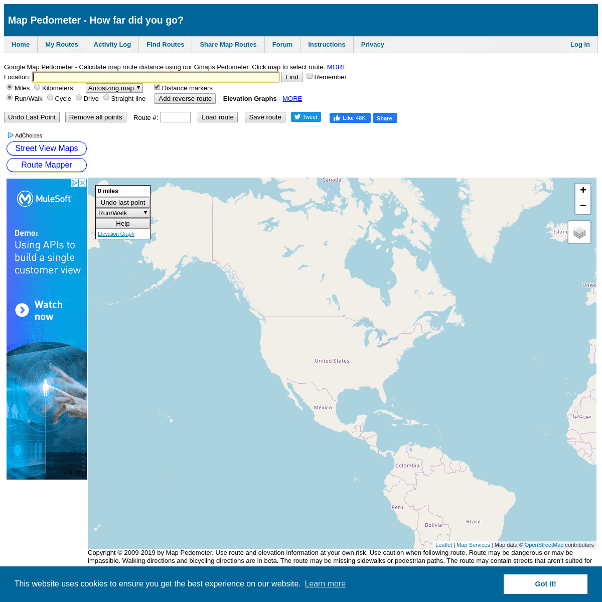
Google Map Pedometer - Calculate map route distance using our Gmaps Pedometer. Click map to select route. MORE Map Pedometer is a Google Maps Pedometer which allows you to calculate distance traveled for running, walking, cycling, or other activities. By marking points along the Google map, the google pedometer / map pedometer feature will compute the distance of your route. Route distance is displayed in miles or kilometers. * Enter a location in the location field and click find to locate a position on the map. The Google Pedometer will update the Google map to display your new location. * Click a location on the Map Pedometer map to mark your firstpoint.
* Click additional locations on the Map Pedometer map to draw your route. The Google Pedometer automatically computes your distance. * Click on the miles or kilometers radio box to switch the Google Pedometer between miles and kilometers. * Select Run/Walk, Cycle, Drive, or Straight line to modify the way the map route is computed between marked points. * Click and drag the last point marker to move point's location. The Google Pedometer will update with the new distance. * Routes, distances, map zoom level, and map units can be saved orretrieved.
* Click on the Street View button to see a street level view of the last selected point (when available). Once enabled, the street view window will be updated as you add new points to your route. The street view indicator (pegman) can also be dragged to any location with an available street view. * Save your route by clicking on the Save Route button on the Map Pedometer home page. Bookmark the saved route link so that the route can be loaded in the future. * After saving a route, the page will be refreshed and your Map Pedometer route link will be displayed in your browser's navigation bar. You can send this link to your friends to share your Google MapPedometer route.
* Load your route by entering the route number in the route number box and clicking on Load Route. Map Pedometer will display the route. * The Google Map Pedometer site uses Google maps technology to create a Gmaps Pedometer. * You may want to consult with your doctor before starting an exercise program, weight loss program, or diet. You should know your current fitness level. * Walking, biking/cycling, running, and hiking are all great exercises. But, be careful that you don't over do it. * Keeping a daily diet and exercise log is helpful in any exercise program. Record your walking, running, hiking, or biking/cycling distances. Calculate the number of calories burned during exercise. Some people find it very useful to record their daily calorie intake. Small changes in your diet in addition to your fitness program can make a huge difference. Try eating healthy low calorie snacks instead of high calorie sweets. Studies show that small changes in your diet and calorie intake can greatly help with weight loss. * Many experts recommend 30 to 45 minutes of exercise 3 to 5 days aweek.
* Start any exercise program slowly to avoid injuries. * Be sure you have the correct running shoes, walking shoes, hiking shoes, or biking/cycling shoes. Visit a specialty shoe store for expert advice on the proper shoes for your sport. Running, walking, cycling, and hiking use muscles in different ways. The experts at a shoe store can help determine if you have normal pronation, underpronation, or overpronation. The correct shoe will help support your foot and help minimize injuries. In addition to the correct shoes, orthotics can also be helpful. * A heart rate monitor can help you monitor your heart rate during exercise. You can calculate your target heart rate before you exercise and use the heart rate monitor to ensure your heart rate stays in a safe range while exercising. * A pedometer is a great way to keep track of how far you travel. You can find a good quality pedometer for sale at major online retailers for as little as $15. After exercising, you can compare your pedometer step count to the actual distance computed on the Map Pedometer / Google Pedometer website. * Set goals for yourself both in terms of weight loss and exercise milestones. If you are a runner and your doctor approves, you may want to run in a 5K, 10K, half marathon or even a full marathon. * Share the Map Pedometer site with your friends via Twitter or Facebook. For twitter users, you can easily cut and paste your map route and share the route with your friends. * As an Amazon Associate I earn from qualifying purchases. Location: Remember Miles Kilometers Autosizing map Very large map Large map Medium map Small map Very small map Distance markers Run/Walk Cycle Drive Straight line ELEVATION GRAPHS -MORE
Elevation graphs are now available on both the Map Pedometer home page and the My Routes page. Now you don't have to wonder whether you will encounter any large hills on your running, walking, cycling, or hiking route. The map elevation graph gives you a clear indication of where the hills are and the total elevation increase or elevation decrease along your route. The Elevation/Altitude graph displays the elevation in feet or meters for your selected route. A link which opens the Elevation Graph is located at the top left of the map. Clicking the "Elevation Graph" link opens the Elevation graph dialog box. If you have already added points to your route, an elevation graph will be displayed. You can update the elevation graph by clicking on the "Update" link the dialog box header. Clicking on the X in the dialog header will hide the elevation graph. Elevation graphs along with elevation statistics are available on the My Routes page. You must be a registered user to use the My Routes page. If you are not a registered user, you can become a Map Pedometer registered user for free. To log in or to register for a free Map Pedometer account, visit the Map Pedometer Forum page. Then click on the Register or Login link on the upper right corner of thepage.
Route #:0 miles
Undo last point
Run/WalkCycleDriveStraight lineHelp
Elevation Graph
+−
World map
World topo map
World map & sat
US satellite
US topo map
US topo satellite
Leaflet | Map Services | Map data © OpenStreetMap contributors Copyright © 2009-2019 by Map Pedometer (www.MapPedometer.com). Use route and elevation information at your own risk. Use caution when following route. Route may be dangerous or may be impassible. Walking directions and bicycling directions are in beta. The route may be missing sidewalks or pedestrian paths. The route may contain streets that aren't suited for bicycling. Elevation graphcloseDetails
1