5
More Annotations


2


6
Favourite Annotations


2


2
Text
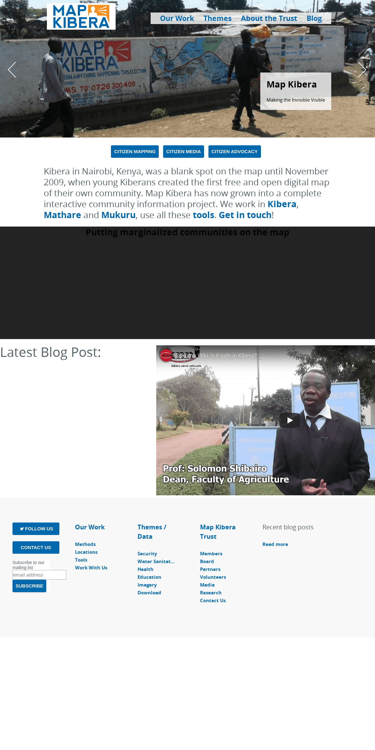
MAP KIBERA | MAP KIBERAOUR WORKBLOGTOOLSMETHODSWORK WITH USLOCATIONS Kibera in Nairobi, Kenya, was a blank spot on the map until November 2009, when young Kiberans created the first free and open digital map of their own community. Map Kibera has now grown into a complete interactive community information project. We work in Kibera,
MAP KIBERA DATA
Prepared Maps. Elections. Education. Education Atlas. Water/Sanitation. WatSan Atlas. Kenya Water for Health map. Water and Sanitation for the Urban Poor. Security Map.MAP KIBERA
Map Kibera designed an open, detailed yet simple Ushahidi Deployment map (Kenya Covid-19 tracker) that illustrates the extent of the infections of the corona virus per county, with help from individual donors through Global Giving. The site has tracked resources made available by many different organizations and the government to haltthe
MAP KIBERA | METHODS Map Kibera | Methods. Map Kibera works with a refined and impact-oriented methodology and theory of change in the Kenyan context. The objective of the organization is to use information to support community goals in our locations of operation. This means having a clear outline of how this will happen.TOOLS - MAP KIBERA
Map Kibera uses tools which we call “Voice” - because they are all about amplifying the voice of the community. Our programs currently use blogging with Wordpress and Ushahidi software to report on issues that affect the community. How it works: A team of reporters works in each slum, editing the sites and writing articles and reports as well as illustrating with photographs. MAP KIBERA | LOCATIONS Methods. Locations. Tools. Work With Us. Kibera Mathare Mukuru. Map Kibera was born in the Kibera slum of Nairobi, but we've grown to connect communities across Nairobi and Kenya. We work in marginalized communities across the country. MAP KIBERA :: GIRLS SECURITY Kibera's first complete free and open map November 2009 This will be a comprehensive look at Girls Security in Kibera: geographic data, and other data sets, interactive maps, videos media and writing, compendium of actors, active and possible web and SMS applications. SETTING UP A GPS UNIT AND BASIC GPS MAPPING TECHNIQUES MANUAL Setting up a GPS Unit and Basic GPS Mapping Techniques Manual 1 Introduction This manual is intended to provide users with a basic understanding of a Garmin eTrex GPSSECURITY MAP FINAL
Golf Course A B C D E F G H I 1 2 3 4 36°48'0"E 36°48'0"E 36°47'30"E 36°47'30"E 36°47'0"E 36°47'0"E 36°46'30"E 36°46'30"E 1°18'30"S 1°18'30"S 1°19'0"S 1 A B C D E F G H I MAP KIBERA EDUCATION HTTP://MAPKIBERA MAP KIBERA Education This map is an overlay of information obtained through a four-step process, which involved stakeholder meetings, data collection by 13 Kibera mappers, MAP KIBERA | MAP KIBERAOUR WORKBLOGTOOLSMETHODSWORK WITH USLOCATIONS Kibera in Nairobi, Kenya, was a blank spot on the map until November 2009, when young Kiberans created the first free and open digital map of their own community. Map Kibera has now grown into a complete interactive community information project. We work in Kibera,MAP KIBERA DATA
Prepared Maps. Elections. Education. Education Atlas. Water/Sanitation. WatSan Atlas. Kenya Water for Health map. Water and Sanitation for the Urban Poor. Security Map.MAP KIBERA
Map Kibera designed an open, detailed yet simple Ushahidi Deployment map (Kenya Covid-19 tracker) that illustrates the extent of the infections of the corona virus per county, with help from individual donors through Global Giving. The site has tracked resources made available by many different organizations and the government to haltthe
MAP KIBERA | METHODS Map Kibera | Methods. Map Kibera works with a refined and impact-oriented methodology and theory of change in the Kenyan context. The objective of the organization is to use information to support community goals in our locations of operation. This means having a clear outline of how this will happen.TOOLS - MAP KIBERA
Map Kibera uses tools which we call “Voice” - because they are all about amplifying the voice of the community. Our programs currently use blogging with Wordpress and Ushahidi software to report on issues that affect the community. How it works: A team of reporters works in each slum, editing the sites and writing articles and reports as well as illustrating with photographs. MAP KIBERA | LOCATIONS Methods. Locations. Tools. Work With Us. Kibera Mathare Mukuru. Map Kibera was born in the Kibera slum of Nairobi, but we've grown to connect communities across Nairobi and Kenya. We work in marginalized communities across the country. MAP KIBERA :: GIRLS SECURITY Kibera's first complete free and open map November 2009 This will be a comprehensive look at Girls Security in Kibera: geographic data, and other data sets, interactive maps, videos media and writing, compendium of actors, active and possible web and SMS applications. SETTING UP A GPS UNIT AND BASIC GPS MAPPING TECHNIQUES MANUAL Setting up a GPS Unit and Basic GPS Mapping Techniques Manual 1 Introduction This manual is intended to provide users with a basic understanding of a Garmin eTrex GPSSECURITY MAP FINAL
Golf Course A B C D E F G H I 1 2 3 4 36°48'0"E 36°48'0"E 36°47'30"E 36°47'30"E 36°47'0"E 36°47'0"E 36°46'30"E 36°46'30"E 1°18'30"S 1°18'30"S 1°19'0"S 1 A B C D E F G H I MAP KIBERA EDUCATION HTTP://MAPKIBERA MAP KIBERA Education This map is an overlay of information obtained through a four-step process, which involved stakeholder meetings, data collection by 13 Kibera mappers,MAP KIBERA
Map Kibera designed an open, detailed yet simple Ushahidi Deployment map (Kenya Covid-19 tracker) that illustrates the extent of the infections of the corona virus per county, with help from individual donors through Global Giving. The site has tracked resources made available by many different organizations and the government to haltthe
MAP KIBERA | LOCATIONS Methods. Locations. Tools. Work With Us. Kibera Mathare Mukuru. Map Kibera was born in the Kibera slum of Nairobi, but we've grown to connect communities across Nairobi and Kenya. We work in marginalized communities across the country.MAP KIBERA | WORK
Learn how we work and work with us Map Kibera does things differently. Centered in the community, technically sophisticated, open andconnected.
MAP KIBERA’S RESPONSE TO COVID-19 Please help Map Kibera’s Covid-19 efforts by donating now via Global Giving!. As cases of coronavirus continue to mount in Kenya, Map Kibera has launched the Kenya Covid-19 Tracker.The tracker uses Ushahidi’s platform to track cases throughout the country, related news, and key initiatives underway to help citizens. Map Kibera has details on many Kibera-related resources, and is working MAP KIBERA | WORK WITH US Map Kibera Trust. About Members Board Partners Volunteers Media Research Contact Us.GPS - MAP KIBERA
Unit Id Make/model Serial # Configuration Current location Future locations Notes Banner 1 3m x .75m User:Mikel: www.OpenStreetMap.org. We're making a map of your area today. MAP KIBERA | MAP KIBERA Map Kibera | Map Kibera2010 - MAP KIBERA
This page was last modified on 8 January 2010, at 15:44. This page has been accessed 12,450 times. Privacy policy; About Map Kibera;Disclaimers
MAPPING COUNTIES WITH PARTICIPATORY BUDGETING Mapping Counties with Participatory Budgeting. Kenya’s devolution process and constitutional reforms of 2010 means that Kenya’s counties, of which there are now 47, are directly responsible for a much greater amount of their local development. Some counties have integrated citizen participation in planning by embarking on anintensive
4 LONG-TERM CLASSROOM ACTIVITIES: BUILDING A GIS PROJECT The Use of GIS and ICT to Enhance School Geography 4. Long-term classroom activities: Building a GIS project - 156 - 4.3 Tutorials The tutorials presented in this section can be classified into threecategories.
MAP KIBERA | MAP KIBERAOUR WORKBLOGTOOLSMETHODSWORK WITH USLOCATIONS Kibera in Nairobi, Kenya, was a blank spot on the map until November 2009, when young Kiberans created the first free and open digital map of their own community. Map Kibera has now grown into a complete interactive community information project. We work in Kibera,MAP KIBERA DATA
Prepared Maps. Elections. Education. Education Atlas. Water/Sanitation. WatSan Atlas. Kenya Water for Health map. Water and Sanitation for the Urban Poor. Security Map. MAP KIBERA | METHODS Map Kibera | Methods. Map Kibera works with a refined and impact-oriented methodology and theory of change in the Kenyan context. The objective of the organization is to use information to support community goals in our locations of operation. This means having a clear outline of how this will happen. MAP KIBERA | LOCATIONS Methods. Locations. Tools. Work With Us. Kibera Mathare Mukuru. Map Kibera was born in the Kibera slum of Nairobi, but we've grown to connect communities across Nairobi and Kenya. We work in marginalized communities across the country.TOOLS - MAP KIBERA
Map Kibera uses tools which we call “Voice” - because they are all about amplifying the voice of the community. Our programs currently use blogging with Wordpress and Ushahidi software to report on issues that affect the community. How it works: A team of reporters works in each slum, editing the sites and writing articles and reports as well as illustrating with photographs. MAP KIBERA :: GIRLS SECURITY Kibera's first complete free and open map November 2009 This will be a comprehensive look at Girls Security in Kibera: geographic data, and other data sets, interactive maps, videos media and writing, compendium of actors, active and possible web and SMS applications. SETTING UP A GPS UNIT AND BASIC GPS MAPPING TECHNIQUES MANUAL Setting up a GPS Unit and Basic GPS Mapping Techniques Manual 1 Introduction This manual is intended to provide users with a basic understanding of a Garmin eTrex GPSSECURITY MAP FINAL
Golf Course A B C D E F G H I 1 2 3 4 36°48'0"E 36°48'0"E 36°47'30"E 36°47'30"E 36°47'0"E 36°47'0"E 36°46'30"E 36°46'30"E 1°18'30"S 1°18'30"S 1°19'0"S 1 MAP KIBERA | MAP KIBERA Map Kibera | Map Kibera A B C D E F G H I MAP KIBERA EDUCATION HTTP://MAPKIBERA MAP KIBERA Education This map is an overlay of information obtained through a four-step process, which involved stakeholder meetings, data collection by 13 Kibera mappers, MAP KIBERA | MAP KIBERAOUR WORKBLOGTOOLSMETHODSWORK WITH USLOCATIONS Kibera in Nairobi, Kenya, was a blank spot on the map until November 2009, when young Kiberans created the first free and open digital map of their own community. Map Kibera has now grown into a complete interactive community information project. We work in Kibera,MAP KIBERA DATA
Prepared Maps. Elections. Education. Education Atlas. Water/Sanitation. WatSan Atlas. Kenya Water for Health map. Water and Sanitation for the Urban Poor. Security Map. MAP KIBERA | METHODS Map Kibera | Methods. Map Kibera works with a refined and impact-oriented methodology and theory of change in the Kenyan context. The objective of the organization is to use information to support community goals in our locations of operation. This means having a clear outline of how this will happen. MAP KIBERA | LOCATIONS Methods. Locations. Tools. Work With Us. Kibera Mathare Mukuru. Map Kibera was born in the Kibera slum of Nairobi, but we've grown to connect communities across Nairobi and Kenya. We work in marginalized communities across the country.TOOLS - MAP KIBERA
Map Kibera uses tools which we call “Voice” - because they are all about amplifying the voice of the community. Our programs currently use blogging with Wordpress and Ushahidi software to report on issues that affect the community. How it works: A team of reporters works in each slum, editing the sites and writing articles and reports as well as illustrating with photographs. MAP KIBERA :: GIRLS SECURITY Kibera's first complete free and open map November 2009 This will be a comprehensive look at Girls Security in Kibera: geographic data, and other data sets, interactive maps, videos media and writing, compendium of actors, active and possible web and SMS applications. SETTING UP A GPS UNIT AND BASIC GPS MAPPING TECHNIQUES MANUAL Setting up a GPS Unit and Basic GPS Mapping Techniques Manual 1 Introduction This manual is intended to provide users with a basic understanding of a Garmin eTrex GPSSECURITY MAP FINAL
Golf Course A B C D E F G H I 1 2 3 4 36°48'0"E 36°48'0"E 36°47'30"E 36°47'30"E 36°47'0"E 36°47'0"E 36°46'30"E 36°46'30"E 1°18'30"S 1°18'30"S 1°19'0"S 1 MAP KIBERA | MAP KIBERA Map Kibera | Map Kibera A B C D E F G H I MAP KIBERA EDUCATION HTTP://MAPKIBERA MAP KIBERA Education This map is an overlay of information obtained through a four-step process, which involved stakeholder meetings, data collection by 13 Kibera mappers,MAP KIBERA | TOOLS
Map Kibera uses tools which we call “Voice” - because they are all about amplifying the voice of the community. Our programs currently use blogging with Wordpress and Ushahidi software to report on issues that affect the community. How it works: A team of reporters works in each slum, editing the sites and writing articles and reports as well as illustrating with photographs. MAP KIBERA’S RESPONSE TO COVID-19 Please help Map Kibera’s Covid-19 efforts by donating now via Global Giving!. As cases of coronavirus continue to mount in Kenya, Map Kibera has launched the Kenya Covid-19 Tracker.The tracker uses Ushahidi’s platform to track cases throughout the country, related news, and key initiatives underway to help citizens. Map Kibera has details on many Kibera-related resources, and is workingMAP KIBERA | WORK
Learn how we work and work with us Map Kibera does things differently. Centered in the community, technically sophisticated, open andconnected.
MAP KIBERA | LOCATIONS Methods. Locations. Tools. Work With Us. Kibera Mathare Mukuru. Map Kibera was born in the Kibera slum of Nairobi, but we've grown to connect communities across Nairobi and Kenya. We work in marginalized communities across the country. MAP KIBERA | WORK WITH US Map Kibera Trust. About Members Board Partners Volunteers Media Research Contact Us.MAP KIBERA
Map Kibera trained hundreds of young people and professionals last year, to contribute to OpenStreetMap and report on their communities. We created manuals, and as all of our work and outputs are shared in the commons, we’re releasing them here.. The single best consolidated open guide for teaching OpenStreetMap is definitely LearnOSM.If there’s any place I think the Map Kibera materialsMAP MATHARE DATA
Images. Map Mathare map; Shapefiles. Transport; Health; Security; Education; Watsan; Religion; Boundary; Polling Places; KML. mathare.kml; CSV. health.csv; education A B C D E F G H I MAP KIBERA EDUCATION HTTP://MAPKIBERA MAP KIBERA Education This map is an overlay of information obtained through a four-step process, which involved stakeholder meetings, data collection by 13 Kibera mappers, OUTCOMES AND LEARNINGS FROM OPEN SCHOOLS KENYA MAPPING IN Outcomes and Learnings from Open Schools Kenya mapping in Kangemi. The schools mapping of the Kangemi slum and associated surroundings was a very successful exercise, and provided much-needed information for everyone from Kangemi’s residents and parents to policy advisers and education experts to governmental education officials. MAPPING COUNTIES WITH PARTICIPATORY BUDGETING Mapping Counties with Participatory Budgeting. Kenya’s devolution process and constitutional reforms of 2010 means that Kenya’s counties, of which there are now 47, are directly responsible for a much greater amount of their local development. Some counties have integrated citizen participation in planning by embarking on anintensive
MAP KIBERA | MAP KIBERAOUR WORKBLOGTOOLSMETHODSWORK WITH USLOCATIONS Kibera in Nairobi, Kenya, was a blank spot on the map until November 2009, when young Kiberans created the first free and open digital map of their own community. Map Kibera has now grown into a complete interactive community information project. We work in Kibera,MAP KIBERA DATA
Prepared Maps. Elections. Education. Education Atlas. Water/Sanitation. WatSan Atlas. Kenya Water for Health map. Water and Sanitation for the Urban Poor. Security Map.TOOLS - MAP KIBERA
Map Kibera uses tools which we call “Voice” - because they are all about amplifying the voice of the community. Our programs currently use blogging with Wordpress and Ushahidi software to report on issues that affect the community. How it works: A team of reporters works in each slum, editing the sites and writing articles and reports as well as illustrating with photographs. MAP KIBERA | METHODS Map Kibera | Methods. Map Kibera works with a refined and impact-oriented methodology and theory of change in the Kenyan context. The objective of the organization is to use information to support community goals in our locations of operation. This means having a clear outline of how this will happen. MAP KIBERA | LOCATIONS Methods. Locations. Tools. Work With Us. Kibera Mathare Mukuru. Map Kibera was born in the Kibera slum of Nairobi, but we've grown to connect communities across Nairobi and Kenya. We work in marginalized communities across the country. MAP KIBERA :: GIRLS SECURITY Kibera's first complete free and open map November 2009 This will be a comprehensive look at Girls Security in Kibera: geographic data, and other data sets, interactive maps, videos media and writing, compendium of actors, active and possible web and SMS applications. SETTING UP A GPS UNIT AND BASIC GPS MAPPING TECHNIQUES MANUAL Setting up a GPS Unit and Basic GPS Mapping Techniques Manual 1 Introduction This manual is intended to provide users with a basic understanding of a Garmin eTrex GPSMAPPING KIBERA
1. Introduction. Kibera is one of the world’s largest slums. Its area of 225 hectares is split in half by a railway, and bordered by a dam, a golf course and housing complexes.SECURITY MAP FINAL
Golf Course A B C D E F G H I 1 2 3 4 36°48'0"E 36°48'0"E 36°47'30"E 36°47'30"E 36°47'0"E 36°47'0"E 36°46'30"E 36°46'30"E 1°18'30"S 1°18'30"S 1°19'0"S 1 A B C D E F G H I MAP KIBERA EDUCATION HTTP://MAPKIBERA MAP KIBERA Education This map is an overlay of information obtained through a four-step process, which involved stakeholder meetings, data collection by 13 Kibera mappers, MAP KIBERA | MAP KIBERAOUR WORKBLOGTOOLSMETHODSWORK WITH USLOCATIONS Kibera in Nairobi, Kenya, was a blank spot on the map until November 2009, when young Kiberans created the first free and open digital map of their own community. Map Kibera has now grown into a complete interactive community information project. We work in Kibera,MAP KIBERA DATA
Prepared Maps. Elections. Education. Education Atlas. Water/Sanitation. WatSan Atlas. Kenya Water for Health map. Water and Sanitation for the Urban Poor. Security Map.TOOLS - MAP KIBERA
Map Kibera uses tools which we call “Voice” - because they are all about amplifying the voice of the community. Our programs currently use blogging with Wordpress and Ushahidi software to report on issues that affect the community. How it works: A team of reporters works in each slum, editing the sites and writing articles and reports as well as illustrating with photographs. MAP KIBERA | METHODS Map Kibera | Methods. Map Kibera works with a refined and impact-oriented methodology and theory of change in the Kenyan context. The objective of the organization is to use information to support community goals in our locations of operation. This means having a clear outline of how this will happen. MAP KIBERA | LOCATIONS Methods. Locations. Tools. Work With Us. Kibera Mathare Mukuru. Map Kibera was born in the Kibera slum of Nairobi, but we've grown to connect communities across Nairobi and Kenya. We work in marginalized communities across the country. MAP KIBERA :: GIRLS SECURITY Kibera's first complete free and open map November 2009 This will be a comprehensive look at Girls Security in Kibera: geographic data, and other data sets, interactive maps, videos media and writing, compendium of actors, active and possible web and SMS applications. SETTING UP A GPS UNIT AND BASIC GPS MAPPING TECHNIQUES MANUAL Setting up a GPS Unit and Basic GPS Mapping Techniques Manual 1 Introduction This manual is intended to provide users with a basic understanding of a Garmin eTrex GPSMAPPING KIBERA
1. Introduction. Kibera is one of the world’s largest slums. Its area of 225 hectares is split in half by a railway, and bordered by a dam, a golf course and housing complexes.SECURITY MAP FINAL
Golf Course A B C D E F G H I 1 2 3 4 36°48'0"E 36°48'0"E 36°47'30"E 36°47'30"E 36°47'0"E 36°47'0"E 36°46'30"E 36°46'30"E 1°18'30"S 1°18'30"S 1°19'0"S 1 A B C D E F G H I MAP KIBERA EDUCATION HTTP://MAPKIBERA MAP KIBERA Education This map is an overlay of information obtained through a four-step process, which involved stakeholder meetings, data collection by 13 Kibera mappers,MAP KIBERA
Map Kibera designed an open, detailed yet simple Ushahidi Deployment map (Kenya Covid-19 tracker) that illustrates the extent of the infections of the corona virus per county, with help from individual donors through Global Giving. The site has tracked resources made available by many different organizations and the government to haltthe
MAP KIBERA | LOCATIONS Methods. Locations. Tools. Work With Us. Kibera Mathare Mukuru. Map Kibera was born in the Kibera slum of Nairobi, but we've grown to connect communities across Nairobi and Kenya. We work in marginalized communities across the country.MAP KIBERA | WORK
Learn how we work and work with us Map Kibera does things differently. Centered in the community, technically sophisticated, open andconnected.
MAP KIBERA | WORK WITH US Map Kibera Trust. About Members Board Partners Volunteers Media Research Contact Us.GPS BABEL MANUAL
Input > Garmin serial/USB protocol Translation Options > make sure the Waypoints, Routes, and Tracks are checked Output > File > GPX XML GPX, or GPS exchange format, is an XML file format for storing coordinate data.It can store waypoints, tracks, and routes in A B C D E F G H I MAP KIBERA EDUCATION HTTP://MAPKIBERA MAP KIBERA Education This map is an overlay of information obtained through a four-step process, which involved stakeholder meetings, data collection by 13 Kibera mappers, MAP KIBERA | MAP KIBERA Map Kibera | Map Kibera WATER AND SANITATION N¼ ëx ëx ëx ëx ëx ëx ëx ëx ëx ëx ëxëx ëx ëx ëx ëx ëx ëx ëx ëx ëx ëxëx ëxëx ëx ëxëx ëx ëx ëx ëx ëx ëx ëx ëx ëx ëx ëxëxëx 4 LONG-TERM CLASSROOM ACTIVITIES: BUILDING A GIS PROJECT The Use of GIS and ICT to Enhance School Geography 4. Long-term classroom activities: Building a GIS project - 156 - 4.3 Tutorials The tutorials presented in this section can be classified into threecategories.
INFER RING HUMAN DYNAMI CS IN SL UMS USI NG MO BI LE P HO Infer ring Human Dynami cs in Sl ums Usi ng Mo bi le P ho ne Data Am y P . W esolo wski Col lege of the A tlantic, 105 Eden St., Bar Harb or,ME 04069 and
MAP KIBERA | MAP KIBERAOUR WORKBLOGTOOLSMETHODSWORK WITH USLOCATIONS Kibera in Nairobi, Kenya, was a blank spot on the map until November 2009, when young Kiberans created the first free and open digital map of their own community. Map Kibera has now grown into a complete interactive community information project. We work in Kibera,MAP KIBERA DATA
Prepared Maps. Elections. Education. Education Atlas. Water/Sanitation. WatSan Atlas. Kenya Water for Health map. Water and Sanitation for the Urban Poor. Security Map. MAP KIBERA | METHODS Map Kibera | Methods. Map Kibera works with a refined and impact-oriented methodology and theory of change in the Kenyan context. The objective of the organization is to use information to support community goals in our locations of operation. This means having a clear outline of how this will happen.TOOLS - MAP KIBERA
Map Kibera uses tools which we call “Voice” - because they are all about amplifying the voice of the community. Our programs currently use blogging with Wordpress and Ushahidi software to report on issues that affect the community. How it works: A team of reporters works in each slum, editing the sites and writing articles and reports as well as illustrating with photographs. MAP KIBERA | LOCATIONS Methods. Locations. Tools. Work With Us. Kibera Mathare Mukuru. Map Kibera was born in the Kibera slum of Nairobi, but we've grown to connect communities across Nairobi and Kenya. We work in marginalized communities across the country. MAP KIBERA :: GIRLS SECURITY Kibera's first complete free and open map November 2009 This will be a comprehensive look at Girls Security in Kibera: geographic data, and other data sets, interactive maps, videos media and writing, compendium of actors, active and possible web and SMS applications.MAPPING KIBERA
1. Introduction. Kibera is one of the world’s largest slums. Its area of 225 hectares is split in half by a railway, and bordered by a dam, a golf course and housing complexes. SETTING UP A GPS UNIT AND BASIC GPS MAPPING TECHNIQUES MANUAL Setting up a GPS Unit and Basic GPS Mapping Techniques Manual 1 Introduction This manual is intended to provide users with a basic understanding of a Garmin eTrex GPSSECURITY MAP FINAL
Golf Course A B C D E F G H I 1 2 3 4 36°48'0"E 36°48'0"E 36°47'30"E 36°47'30"E 36°47'0"E 36°47'0"E 36°46'30"E 36°46'30"E 1°18'30"S 1°18'30"S 1°19'0"S 1 A B C D E F G H I MAP KIBERA EDUCATION HTTP://MAPKIBERA MAP KIBERA Education This map is an overlay of information obtained through a four-step process, which involved stakeholder meetings, data collection by 13 Kibera mappers, MAP KIBERA | MAP KIBERAOUR WORKBLOGTOOLSMETHODSWORK WITH USLOCATIONS Kibera in Nairobi, Kenya, was a blank spot on the map until November 2009, when young Kiberans created the first free and open digital map of their own community. Map Kibera has now grown into a complete interactive community information project. We work in Kibera,MAP KIBERA DATA
Prepared Maps. Elections. Education. Education Atlas. Water/Sanitation. WatSan Atlas. Kenya Water for Health map. Water and Sanitation for the Urban Poor. Security Map. MAP KIBERA | METHODS Map Kibera | Methods. Map Kibera works with a refined and impact-oriented methodology and theory of change in the Kenyan context. The objective of the organization is to use information to support community goals in our locations of operation. This means having a clear outline of how this will happen.TOOLS - MAP KIBERA
Map Kibera uses tools which we call “Voice” - because they are all about amplifying the voice of the community. Our programs currently use blogging with Wordpress and Ushahidi software to report on issues that affect the community. How it works: A team of reporters works in each slum, editing the sites and writing articles and reports as well as illustrating with photographs. MAP KIBERA | LOCATIONS Methods. Locations. Tools. Work With Us. Kibera Mathare Mukuru. Map Kibera was born in the Kibera slum of Nairobi, but we've grown to connect communities across Nairobi and Kenya. We work in marginalized communities across the country. MAP KIBERA :: GIRLS SECURITY Kibera's first complete free and open map November 2009 This will be a comprehensive look at Girls Security in Kibera: geographic data, and other data sets, interactive maps, videos media and writing, compendium of actors, active and possible web and SMS applications.MAPPING KIBERA
1. Introduction. Kibera is one of the world’s largest slums. Its area of 225 hectares is split in half by a railway, and bordered by a dam, a golf course and housing complexes. SETTING UP A GPS UNIT AND BASIC GPS MAPPING TECHNIQUES MANUAL Setting up a GPS Unit and Basic GPS Mapping Techniques Manual 1 Introduction This manual is intended to provide users with a basic understanding of a Garmin eTrex GPSSECURITY MAP FINAL
Golf Course A B C D E F G H I 1 2 3 4 36°48'0"E 36°48'0"E 36°47'30"E 36°47'30"E 36°47'0"E 36°47'0"E 36°46'30"E 36°46'30"E 1°18'30"S 1°18'30"S 1°19'0"S 1 A B C D E F G H I MAP KIBERA EDUCATION HTTP://MAPKIBERA MAP KIBERA Education This map is an overlay of information obtained through a four-step process, which involved stakeholder meetings, data collection by 13 Kibera mappers,MAP KIBERA
Map Kibera designed an open, detailed yet simple Ushahidi Deployment map (Kenya Covid-19 tracker) that illustrates the extent of the infections of the corona virus per county, with help from individual donors through Global Giving. The site has tracked resources made available by many different organizations and the government to haltthe
MAP KIBERA | LOCATIONS Methods. Locations. Tools. Work With Us. Kibera Mathare Mukuru. Map Kibera was born in the Kibera slum of Nairobi, but we've grown to connect communities across Nairobi and Kenya. We work in marginalized communities across the country.MAP KIBERA | WORK
Learn how we work and work with us Map Kibera does things differently. Centered in the community, technically sophisticated, open andconnected.
MAP KIBERA | WORK WITH US Map Kibera Trust. About Members Board Partners Volunteers Media Research Contact Us.GPS BABEL MANUAL
Input > Garmin serial/USB protocol Translation Options > make sure the Waypoints, Routes, and Tracks are checked Output > File > GPX XML GPX, or GPS exchange format, is an XML file format for storing coordinate data.It can store waypoints, tracks, and routes in MAP KIBERA | MAP KIBERA Map Kibera | Map Kibera WATER AND SANITATION N¼ ëx ëx ëx ëx ëx ëx ëx ëx ëx ëx ëxëx ëx ëx ëx ëx ëx ëx ëx ëx ëx ëxëx ëxëx ëx ëxëx ëx ëx ëx ëx ëx ëx ëx ëx ëx ëx ëxëxëx A B C D E F G H I MAP KIBERA EDUCATION HTTP://MAPKIBERA MAP KIBERA Education Evendebis nobis net omnim sitaspi stiatio om-nienimus aborera nobit quas modi volorio nec-tora tincipi enectiur sit, unt doluptaes dolupta 4 LONG-TERM CLASSROOM ACTIVITIES: BUILDING A GIS PROJECT The Use of GIS and ICT to Enhance School Geography 4. Long-term classroom activities: Building a GIS project - 156 - 4.3 Tutorials The tutorials presented in this section can be classified into threecategories.
INFER RING HUMAN DYNAMI CS IN SL UMS USI NG MO BI LE P HO Infer ring Human Dynami cs in Sl ums Usi ng Mo bi le P ho ne Data Am y P . W esolo wski Col lege of the A tlantic, 105 Eden St., Bar Harb or,ME 04069 and
MAP KIBERA | MAP KIBERAOUR WORKBLOGTOOLSMETHODSWORK WITH USLOCATIONS Kibera in Nairobi, Kenya, was a blank spot on the map until November 2009, when young Kiberans created the first free and open digital map of their own community. Map Kibera has now grown into a complete interactive community information project. We work in Kibera,MAP KIBERA DATA
Prepared Maps. Elections. Education. Education Atlas. Water/Sanitation. WatSan Atlas. Kenya Water for Health map. Water and Sanitation for the Urban Poor. Security Map. MAP KIBERA | METHODS Map Kibera | Methods. Map Kibera works with a refined and impact-oriented methodology and theory of change in the Kenyan context. The objective of the organization is to use information to support community goals in our locations of operation. This means having a clear outline of how this will happen. MAP KIBERA | LOCATIONS Methods. Locations. Tools. Work With Us. Kibera Mathare Mukuru. Map Kibera was born in the Kibera slum of Nairobi, but we've grown to connect communities across Nairobi and Kenya. We work in marginalized communities across the country.TOOLS - MAP KIBERA
Map Kibera uses tools which we call “Voice” - because they are all about amplifying the voice of the community. Our programs currently use blogging with Wordpress and Ushahidi software to report on issues that affect the community. How it works: A team of reporters works in each slum, editing the sites and writing articles and reports as well as illustrating with photographs. MAP KIBERA :: GIRLS SECURITY Kibera's first complete free and open map November 2009 This will be a comprehensive look at Girls Security in Kibera: geographic data, and other data sets, interactive maps, videos media and writing, compendium of actors, active and possible web and SMS applications. SETTING UP A GPS UNIT AND BASIC GPS MAPPING TECHNIQUES MANUAL Setting up a GPS Unit and Basic GPS Mapping Techniques Manual 1 Introduction This manual is intended to provide users with a basic understanding of a Garmin eTrex GPSSECURITY MAP FINAL
Golf Course A B C D E F G H I 1 2 3 4 36°48'0"E 36°48'0"E 36°47'30"E 36°47'30"E 36°47'0"E 36°47'0"E 36°46'30"E 36°46'30"E 1°18'30"S 1°18'30"S 1°19'0"S 1 A B C D E F G H I MAP KIBERA EDUCATION HTTP://MAPKIBERA MAP KIBERA Education This map is an overlay of information obtained through a four-step process, which involved stakeholder meetings, data collection by 13 Kibera mappers, MAP KIBERA | MAP KIBERA Map Kibera | Map Kibera MAP KIBERA | MAP KIBERAOUR WORKBLOGTOOLSMETHODSWORK WITH USLOCATIONS Kibera in Nairobi, Kenya, was a blank spot on the map until November 2009, when young Kiberans created the first free and open digital map of their own community. Map Kibera has now grown into a complete interactive community information project. We work in Kibera,MAP KIBERA DATA
Prepared Maps. Elections. Education. Education Atlas. Water/Sanitation. WatSan Atlas. Kenya Water for Health map. Water and Sanitation for the Urban Poor. Security Map. MAP KIBERA | METHODS Map Kibera | Methods. Map Kibera works with a refined and impact-oriented methodology and theory of change in the Kenyan context. The objective of the organization is to use information to support community goals in our locations of operation. This means having a clear outline of how this will happen. MAP KIBERA | LOCATIONS Methods. Locations. Tools. Work With Us. Kibera Mathare Mukuru. Map Kibera was born in the Kibera slum of Nairobi, but we've grown to connect communities across Nairobi and Kenya. We work in marginalized communities across the country.TOOLS - MAP KIBERA
Map Kibera uses tools which we call “Voice” - because they are all about amplifying the voice of the community. Our programs currently use blogging with Wordpress and Ushahidi software to report on issues that affect the community. How it works: A team of reporters works in each slum, editing the sites and writing articles and reports as well as illustrating with photographs. MAP KIBERA :: GIRLS SECURITY Kibera's first complete free and open map November 2009 This will be a comprehensive look at Girls Security in Kibera: geographic data, and other data sets, interactive maps, videos media and writing, compendium of actors, active and possible web and SMS applications. SETTING UP A GPS UNIT AND BASIC GPS MAPPING TECHNIQUES MANUAL Setting up a GPS Unit and Basic GPS Mapping Techniques Manual 1 Introduction This manual is intended to provide users with a basic understanding of a Garmin eTrex GPSSECURITY MAP FINAL
Golf Course A B C D E F G H I 1 2 3 4 36°48'0"E 36°48'0"E 36°47'30"E 36°47'30"E 36°47'0"E 36°47'0"E 36°46'30"E 36°46'30"E 1°18'30"S 1°18'30"S 1°19'0"S 1 A B C D E F G H I MAP KIBERA EDUCATION HTTP://MAPKIBERA MAP KIBERA Education This map is an overlay of information obtained through a four-step process, which involved stakeholder meetings, data collection by 13 Kibera mappers, MAP KIBERA | MAP KIBERA Map Kibera | Map KiberaTOOLS - MAP KIBERA
Map Kibera uses tools which we call “Voice” - because they are all about amplifying the voice of the community. Our programs currently use blogging with Wordpress and Ushahidi software to report on issues that affect the community. How it works: A team of reporters works in each slum, editing the sites and writing articles and reports as well as illustrating with photographs. MAP KIBERA | LOCATIONS Methods. Locations. Tools. Work With Us. Kibera Mathare Mukuru. Map Kibera was born in the Kibera slum of Nairobi, but we've grown to connect communities across Nairobi and Kenya. We work in marginalized communities across the country.MAP KIBERA
Map Kibera designed an open, detailed yet simple Ushahidi Deployment map (Kenya Covid-19 tracker) that illustrates the extent of the infections of the corona virus per county, with help from individual donors through Global Giving. The site has tracked resources made available by many different organizations and the government to haltthe
MAP KIBERA | WORK
Learn how we work and work with us Map Kibera does things differently. Centered in the community, technically sophisticated, open andconnected.
MAP KIBERA’S RESPONSE TO COVID-19 Please help Map Kibera’s Covid-19 efforts by donating now via Global Giving!. As cases of coronavirus continue to mount in Kenya, Map Kibera has launched the Kenya Covid-19 Tracker.The tracker uses Ushahidi’s platform to track cases throughout the country, related news, and key initiatives underway to help citizens. Map Kibera has details on many Kibera-related resources, and is working MAP KIBERA | WORK WITH US Map Kibera Trust. About Members Board Partners Volunteers Media Research Contact Us. RESEARCH - MAP KIBERA - MAP KIBERA Case Studies . Rising Voices Case Study; Getting on the Map; Stuff We've Written . By Erica Hagen: GIZ Social Media Political Participation; IKM Emergent: The Story of Map KiberaMAP KIBERA
Map Kibera trained hundreds of young people and professionals last year, to contribute to OpenStreetMap and report on their communities. We created manuals, and as all of our work and outputs are shared in the commons, we’re releasing them here.. The single best consolidated open guide for teaching OpenStreetMap is definitely LearnOSM.If there’s any place I think the Map Kibera materialsMAP MUKURU DATA
Prepared Maps. Mukuru Kayaba Education. Mukuru Kayaba Water/Sanitation. Mukuru Kayaba Health. Mukuru Kayaba Security. Mukuru Kwa Njenga Education. Mukuru Kwa Njenga Water/Sanitation. Mukuru Kwa Njenga Health. Mukuru Kwa Njenga Security. WATER AND SANITATION N¼ ëx ëx ëx ëx ëx ëx ëx ëx ëx ëx ëxëx ëx ëx ëx ëx ëx ëx ëx ëx ëx ëxëx ëxëx ëx ëxëx ëx ëx ëx ëx ëx ëx ëx ëx ëx ëx ëxëxëx MAP KIBERA | MAP KIBERAOUR WORKBLOGTOOLSMETHODSWORK WITH USLOCATIONS Kibera in Nairobi, Kenya, was a blank spot on the map until November 2009, when young Kiberans created the first free and open digital map of their own community. Map Kibera has now grown into a complete interactive community information project. We work in Kibera,MAP KIBERA DATA
Prepared Maps. Elections. Education. Education Atlas. Water/Sanitation. WatSan Atlas. Kenya Water for Health map. Water and Sanitation for the Urban Poor. Security Map. MAP KIBERA | METHODS Map Kibera | Methods. Map Kibera works with a refined and impact-oriented methodology and theory of change in the Kenyan context. The objective of the organization is to use information to support community goals in our locations of operation. This means having a clear outline of how this will happen. MAP KIBERA | LOCATIONS Methods. Locations. Tools. Work With Us. Kibera Mathare Mukuru. Map Kibera was born in the Kibera slum of Nairobi, but we've grown to connect communities across Nairobi and Kenya. We work in marginalized communities across the country.TOOLS - MAP KIBERA
Map Kibera uses tools which we call “Voice” - because they are all about amplifying the voice of the community. Our programs currently use blogging with Wordpress and Ushahidi software to report on issues that affect the community. How it works: A team of reporters works in each slum, editing the sites and writing articles and reports as well as illustrating with photographs. MAP KIBERA :: GIRLS SECURITY Kibera's first complete free and open map November 2009 This will be a comprehensive look at Girls Security in Kibera: geographic data, and other data sets, interactive maps, videos media and writing, compendium of actors, active and possible web and SMS applications. SETTING UP A GPS UNIT AND BASIC GPS MAPPING TECHNIQUES MANUAL Setting up a GPS Unit and Basic GPS Mapping Techniques Manual 1 Introduction This manual is intended to provide users with a basic understanding of a Garmin eTrex GPSSECURITY MAP FINAL
Golf Course A B C D E F G H I 1 2 3 4 36°48'0"E 36°48'0"E 36°47'30"E 36°47'30"E 36°47'0"E 36°47'0"E 36°46'30"E 36°46'30"E 1°18'30"S 1°18'30"S 1°19'0"S 1 A B C D E F G H I MAP KIBERA EDUCATION HTTP://MAPKIBERA MAP KIBERA Education This map is an overlay of information obtained through a four-step process, which involved stakeholder meetings, data collection by 13 Kibera mappers, MAP KIBERA | MAP KIBERA Map Kibera | Map Kibera MAP KIBERA | MAP KIBERAOUR WORKBLOGTOOLSMETHODSWORK WITH USLOCATIONS Kibera in Nairobi, Kenya, was a blank spot on the map until November 2009, when young Kiberans created the first free and open digital map of their own community. Map Kibera has now grown into a complete interactive community information project. We work in Kibera,MAP KIBERA DATA
Prepared Maps. Elections. Education. Education Atlas. Water/Sanitation. WatSan Atlas. Kenya Water for Health map. Water and Sanitation for the Urban Poor. Security Map. MAP KIBERA | METHODS Map Kibera | Methods. Map Kibera works with a refined and impact-oriented methodology and theory of change in the Kenyan context. The objective of the organization is to use information to support community goals in our locations of operation. This means having a clear outline of how this will happen. MAP KIBERA | LOCATIONS Methods. Locations. Tools. Work With Us. Kibera Mathare Mukuru. Map Kibera was born in the Kibera slum of Nairobi, but we've grown to connect communities across Nairobi and Kenya. We work in marginalized communities across the country.TOOLS - MAP KIBERA
Map Kibera uses tools which we call “Voice” - because they are all about amplifying the voice of the community. Our programs currently use blogging with Wordpress and Ushahidi software to report on issues that affect the community. How it works: A team of reporters works in each slum, editing the sites and writing articles and reports as well as illustrating with photographs. MAP KIBERA :: GIRLS SECURITY Kibera's first complete free and open map November 2009 This will be a comprehensive look at Girls Security in Kibera: geographic data, and other data sets, interactive maps, videos media and writing, compendium of actors, active and possible web and SMS applications. SETTING UP A GPS UNIT AND BASIC GPS MAPPING TECHNIQUES MANUAL Setting up a GPS Unit and Basic GPS Mapping Techniques Manual 1 Introduction This manual is intended to provide users with a basic understanding of a Garmin eTrex GPSSECURITY MAP FINAL
Golf Course A B C D E F G H I 1 2 3 4 36°48'0"E 36°48'0"E 36°47'30"E 36°47'30"E 36°47'0"E 36°47'0"E 36°46'30"E 36°46'30"E 1°18'30"S 1°18'30"S 1°19'0"S 1 A B C D E F G H I MAP KIBERA EDUCATION HTTP://MAPKIBERA MAP KIBERA Education This map is an overlay of information obtained through a four-step process, which involved stakeholder meetings, data collection by 13 Kibera mappers, MAP KIBERA | MAP KIBERA Map Kibera | Map KiberaTOOLS - MAP KIBERA
Map Kibera uses tools which we call “Voice” - because they are all about amplifying the voice of the community. Our programs currently use blogging with Wordpress and Ushahidi software to report on issues that affect the community. How it works: A team of reporters works in each slum, editing the sites and writing articles and reports as well as illustrating with photographs. MAP KIBERA | LOCATIONS Methods. Locations. Tools. Work With Us. Kibera Mathare Mukuru. Map Kibera was born in the Kibera slum of Nairobi, but we've grown to connect communities across Nairobi and Kenya. We work in marginalized communities across the country.MAP KIBERA | WORK
Learn how we work and work with us Map Kibera does things differently. Centered in the community, technically sophisticated, open andconnected.
MAP KIBERA’S RESPONSE TO COVID-19 Please help Map Kibera’s Covid-19 efforts by donating now via Global Giving!. As cases of coronavirus continue to mount in Kenya, Map Kibera has launched the Kenya Covid-19 Tracker.The tracker uses Ushahidi’s platform to track cases throughout the country, related news, and key initiatives underway to help citizens. Map Kibera has details on many Kibera-related resources, and is working MAP KIBERA | WORK WITH US Map Kibera Trust. About Members Board Partners Volunteers Media Research Contact Us.MAP KIBERA
Map Kibera trained hundreds of young people and professionals last year, to contribute to OpenStreetMap and report on their communities. We created manuals, and as all of our work and outputs are shared in the commons, we’re releasing them here.. The single best consolidated open guide for teaching OpenStreetMap is definitely LearnOSM.If there’s any place I think the Map Kibera materialsMAP MATHARE DATA
Images. Map Mathare map; Shapefiles. Transport; Health; Security; Education; Watsan; Religion; Boundary; Polling Places; KML. mathare.kml; CSV. health.csv; education WATER AND SANITATION N¼ ëx ëx ëx ëx ëx ëx ëx ëx ëx ëx ëxëx ëx ëx ëx ëx ëx ëx ëx ëx ëx ëxëx ëxëx ëx ëxëx ëx ëx ëx ëx ëx ëx ëx ëx ëx ëx ëxëxëx OUTCOMES AND LEARNINGS FROM OPEN SCHOOLS KENYA MAPPING IN Outcomes and Learnings from Open Schools Kenya mapping in Kangemi. The schools mapping of the Kangemi slum and associated surroundings was a very successful exercise, and provided much-needed information for everyone from Kangemi’s residents and parents to policy advisers and education experts to governmental education officials. MAPPING COUNTIES WITH PARTICIPATORY BUDGETING Mapping Counties with Participatory Budgeting. Kenya’s devolution process and constitutional reforms of 2010 means that Kenya’s counties, of which there are now 47, are directly responsible for a much greater amount of their local development. Some counties have integrated citizen participation in planning by embarking on anintensive
MAP KIBERA | MAP KIBERAOUR WORKBLOGTOOLSMETHODSWORK WITH USLOCATIONS Kibera in Nairobi, Kenya, was a blank spot on the map until November 2009, when young Kiberans created the first free and open digital map of their own community. Map Kibera has now grown into a complete interactive community information project. We work in Kibera,MAP KIBERA DATA
Prepared Maps. Elections. Education. Education Atlas. Water/Sanitation. WatSan Atlas. Kenya Water for Health map. Water and Sanitation for the Urban Poor. Security Map. MAP KIBERA | METHODS Map Kibera | Methods. Map Kibera works with a refined and impact-oriented methodology and theory of change in the Kenyan context. The objective of the organization is to use information to support community goals in our locations of operation. This means having a clear outline of how this will happen. MAP KIBERA | LOCATIONS Methods. Locations. Tools. Work With Us. Kibera Mathare Mukuru. Map Kibera was born in the Kibera slum of Nairobi, but we've grown to connect communities across Nairobi and Kenya. We work in marginalized communities across the country.TOOLS - MAP KIBERA
Map Kibera uses tools which we call “Voice” - because they are all about amplifying the voice of the community. Our programs currently use blogging with Wordpress and Ushahidi software to report on issues that affect the community. How it works: A team of reporters works in each slum, editing the sites and writing articles and reports as well as illustrating with photographs. MAP KIBERA :: GIRLS SECURITY Kibera's first complete free and open map November 2009 This will be a comprehensive look at Girls Security in Kibera: geographic data, and other data sets, interactive maps, videos media and writing, compendium of actors, active and possible web and SMS applications. SETTING UP A GPS UNIT AND BASIC GPS MAPPING TECHNIQUES MANUAL Setting up a GPS Unit and Basic GPS Mapping Techniques Manual 1 Introduction This manual is intended to provide users with a basic understanding of a Garmin eTrex GPSSECURITY MAP FINAL
Golf Course A B C D E F G H I 1 2 3 4 36°48'0"E 36°48'0"E 36°47'30"E 36°47'30"E 36°47'0"E 36°47'0"E 36°46'30"E 36°46'30"E 1°18'30"S 1°18'30"S 1°19'0"S 1 A B C D E F G H I MAP KIBERA EDUCATION HTTP://MAPKIBERA MAP KIBERA Education This map is an overlay of information obtained through a four-step process, which involved stakeholder meetings, data collection by 13 Kibera mappers, MAP KIBERA | MAP KIBERA Map Kibera | Map Kibera MAP KIBERA | MAP KIBERAOUR WORKBLOGTOOLSMETHODSWORK WITH USLOCATIONS Kibera in Nairobi, Kenya, was a blank spot on the map until November 2009, when young Kiberans created the first free and open digital map of their own community. Map Kibera has now grown into a complete interactive community information project. We work in Kibera,MAP KIBERA DATA
Prepared Maps. Elections. Education. Education Atlas. Water/Sanitation. WatSan Atlas. Kenya Water for Health map. Water and Sanitation for the Urban Poor. Security Map. MAP KIBERA | METHODS Map Kibera | Methods. Map Kibera works with a refined and impact-oriented methodology and theory of change in the Kenyan context. The objective of the organization is to use information to support community goals in our locations of operation. This means having a clear outline of how this will happen. MAP KIBERA | LOCATIONS Methods. Locations. Tools. Work With Us. Kibera Mathare Mukuru. Map Kibera was born in the Kibera slum of Nairobi, but we've grown to connect communities across Nairobi and Kenya. We work in marginalized communities across the country.TOOLS - MAP KIBERA
Map Kibera uses tools which we call “Voice” - because they are all about amplifying the voice of the community. Our programs currently use blogging with Wordpress and Ushahidi software to report on issues that affect the community. How it works: A team of reporters works in each slum, editing the sites and writing articles and reports as well as illustrating with photographs. MAP KIBERA :: GIRLS SECURITY Kibera's first complete free and open map November 2009 This will be a comprehensive look at Girls Security in Kibera: geographic data, and other data sets, interactive maps, videos media and writing, compendium of actors, active and possible web and SMS applications. SETTING UP A GPS UNIT AND BASIC GPS MAPPING TECHNIQUES MANUAL Setting up a GPS Unit and Basic GPS Mapping Techniques Manual 1 Introduction This manual is intended to provide users with a basic understanding of a Garmin eTrex GPSSECURITY MAP FINAL
Golf Course A B C D E F G H I 1 2 3 4 36°48'0"E 36°48'0"E 36°47'30"E 36°47'30"E 36°47'0"E 36°47'0"E 36°46'30"E 36°46'30"E 1°18'30"S 1°18'30"S 1°19'0"S 1 A B C D E F G H I MAP KIBERA EDUCATION HTTP://MAPKIBERA MAP KIBERA Education This map is an overlay of information obtained through a four-step process, which involved stakeholder meetings, data collection by 13 Kibera mappers, MAP KIBERA | MAP KIBERA Map Kibera | Map KiberaTOOLS - MAP KIBERA
Map Kibera uses tools which we call “Voice” - because they are all about amplifying the voice of the community. Our programs currently use blogging with Wordpress and Ushahidi software to report on issues that affect the community. How it works: A team of reporters works in each slum, editing the sites and writing articles and reports as well as illustrating with photographs. MAP KIBERA | LOCATIONS Methods. Locations. Tools. Work With Us. Kibera Mathare Mukuru. Map Kibera was born in the Kibera slum of Nairobi, but we've grown to connect communities across Nairobi and Kenya. We work in marginalized communities across the country.MAP KIBERA
Map Kibera designed an open, detailed yet simple Ushahidi Deployment map (Kenya Covid-19 tracker) that illustrates the extent of the infections of the corona virus per county, with help from individual donors through Global Giving. The site has tracked resources made available by many different organizations and the government to haltthe
MAP KIBERA | WORK
Learn how we work and work with us Map Kibera does things differently. Centered in the community, technically sophisticated, open andconnected.
MAP KIBERA’S RESPONSE TO COVID-19 Please help Map Kibera’s Covid-19 efforts by donating now via Global Giving!. As cases of coronavirus continue to mount in Kenya, Map Kibera has launched the Kenya Covid-19 Tracker.The tracker uses Ushahidi’s platform to track cases throughout the country, related news, and key initiatives underway to help citizens. Map Kibera has details on many Kibera-related resources, and is working MAP KIBERA | WORK WITH US Map Kibera Trust. About Members Board Partners Volunteers Media Research Contact Us. RESEARCH - MAP KIBERA - MAP KIBERA Case Studies . Rising Voices Case Study; Getting on the Map; Stuff We've Written . By Erica Hagen: GIZ Social Media Political Participation; IKM Emergent: The Story of Map KiberaMAP KIBERA
Map Kibera trained hundreds of young people and professionals last year, to contribute to OpenStreetMap and report on their communities. We created manuals, and as all of our work and outputs are shared in the commons, we’re releasing them here.. The single best consolidated open guide for teaching OpenStreetMap is definitely LearnOSM.If there’s any place I think the Map Kibera materialsMAP MUKURU DATA
Prepared Maps. Mukuru Kayaba Education. Mukuru Kayaba Water/Sanitation. Mukuru Kayaba Health. Mukuru Kayaba Security. Mukuru Kwa Njenga Education. Mukuru Kwa Njenga Water/Sanitation. Mukuru Kwa Njenga Health. Mukuru Kwa Njenga Security. WATER AND SANITATION N¼ ëx ëx ëx ëx ëx ëx ëx ëx ëx ëx ëxëx ëx ëx ëx ëx ëx ëx ëx ëx ëx ëxëx ëxëx ëx ëxëx ëx ëx ëx ëx ëx ëx ëx ëx ëx ëx ëxëxëx MAP KIBERA | MAP KIBERAOUR WORKBLOGTOOLSMETHODSWORK WITH USLOCATIONS Kibera in Nairobi, Kenya, was a blank spot on the map until November 2009, when young Kiberans created the first free and open digital map of their own community. Map Kibera has now grown into a complete interactive community information project. We work in Kibera,MAP KIBERA DATA
Prepared Maps. Elections. Education. Education Atlas. Water/Sanitation. WatSan Atlas. Kenya Water for Health map. Water and Sanitation for the Urban Poor. Security Map. MAP KIBERA | METHODS Map Kibera | Methods. Map Kibera works with a refined and impact-oriented methodology and theory of change in the Kenyan context. The objective of the organization is to use information to support community goals in our locations of operation. This means having a clear outline of how this will happen. MAP KIBERA | LOCATIONS Methods. Locations. Tools. Work With Us. Kibera Mathare Mukuru. Map Kibera was born in the Kibera slum of Nairobi, but we've grown to connect communities across Nairobi and Kenya. We work in marginalized communities across the country.TOOLS - MAP KIBERA
Map Kibera uses tools which we call “Voice” - because they are all about amplifying the voice of the community. Our programs currently use blogging with Wordpress and Ushahidi software to report on issues that affect the community. How it works: A team of reporters works in each slum, editing the sites and writing articles and reports as well as illustrating with photographs. MAP KIBERA :: GIRLS SECURITY Kibera's first complete free and open map November 2009 This will be a comprehensive look at Girls Security in Kibera: geographic data, and other data sets, interactive maps, videos media and writing, compendium of actors, active and possible web and SMS applications. SETTING UP A GPS UNIT AND BASIC GPS MAPPING TECHNIQUES MANUAL Setting up a GPS Unit and Basic GPS Mapping Techniques Manual 1 Introduction This manual is intended to provide users with a basic understanding of a Garmin eTrex GPSSECURITY MAP FINAL
Golf Course A B C D E F G H I 1 2 3 4 36°48'0"E 36°48'0"E 36°47'30"E 36°47'30"E 36°47'0"E 36°47'0"E 36°46'30"E 36°46'30"E 1°18'30"S 1°18'30"S 1°19'0"S 1 A B C D E F G H I MAP KIBERA EDUCATION HTTP://MAPKIBERA MAP KIBERA Education This map is an overlay of information obtained through a four-step process, which involved stakeholder meetings, data collection by 13 Kibera mappers, MAP KIBERA | MAP KIBERA Map Kibera | Map Kibera MAP KIBERA | MAP KIBERAOUR WORKBLOGTOOLSMETHODSWORK WITH USLOCATIONS Kibera in Nairobi, Kenya, was a blank spot on the map until November 2009, when young Kiberans created the first free and open digital map of their own community. Map Kibera has now grown into a complete interactive community information project. We work in Kibera,MAP KIBERA DATA
Prepared Maps. Elections. Education. Education Atlas. Water/Sanitation. WatSan Atlas. Kenya Water for Health map. Water and Sanitation for the Urban Poor. Security Map. MAP KIBERA | METHODS Map Kibera | Methods. Map Kibera works with a refined and impact-oriented methodology and theory of change in the Kenyan context. The objective of the organization is to use information to support community goals in our locations of operation. This means having a clear outline of how this will happen. MAP KIBERA | LOCATIONS Methods. Locations. Tools. Work With Us. Kibera Mathare Mukuru. Map Kibera was born in the Kibera slum of Nairobi, but we've grown to connect communities across Nairobi and Kenya. We work in marginalized communities across the country.TOOLS - MAP KIBERA
Map Kibera uses tools which we call “Voice” - because they are all about amplifying the voice of the community. Our programs currently use blogging with Wordpress and Ushahidi software to report on issues that affect the community. How it works: A team of reporters works in each slum, editing the sites and writing articles and reports as well as illustrating with photographs. MAP KIBERA :: GIRLS SECURITY Kibera's first complete free and open map November 2009 This will be a comprehensive look at Girls Security in Kibera: geographic data, and other data sets, interactive maps, videos media and writing, compendium of actors, active and possible web and SMS applications.TOOLS - MAP KIBERA
Map Kibera uses tools which we call “Voice” - because they are all about amplifying the voice of the community. Our programs currently use blogging with Wordpress and Ushahidi software to report on issues that affect the community. How it works: A team of reporters works in each slum, editing the sites and writing articles and reports as well as illustrating with photographs. MAP KIBERA | LOCATIONS Methods. Locations. Tools. Work With Us. Kibera Mathare Mukuru. Map Kibera was born in the Kibera slum of Nairobi, but we've grown to connect communities across Nairobi and Kenya. We work in marginalized communities across the country.MAP KIBERA
Map Kibera designed an open, detailed yet simple Ushahidi Deployment map (Kenya Covid-19 tracker) that illustrates the extent of the infections of the corona virus per county, with help from individual donors through Global Giving. The site has tracked resources made available by many different organizations and the government to haltthe
MAP KIBERA | WORK
Learn how we work and work with us Map Kibera does things differently. Centered in the community, technically sophisticated, open andconnected.
MAP KIBERA’S RESPONSE TO COVID-19 Please help Map Kibera’s Covid-19 efforts by donating now via Global Giving!. As cases of coronavirus continue to mount in Kenya, Map Kibera has launched the Kenya Covid-19 Tracker.The tracker uses Ushahidi’s platform to track cases throughout the country, related news, and key initiatives underway to help citizens. Map Kibera has details on many Kibera-related resources, and is working MAP KIBERA | WORK WITH US Map Kibera Trust. About Members Board Partners Volunteers Media Research Contact Us. RESEARCH - MAP KIBERA - MAP KIBERA Case Studies . Rising Voices Case Study; Getting on the Map; Stuff We've Written . By Erica Hagen: GIZ Social Media Political Participation; IKM Emergent: The Story of Map KiberaMAP KIBERA
Map Kibera trained hundreds of young people and professionals last year, to contribute to OpenStreetMap and report on their communities. We created manuals, and as all of our work and outputs are shared in the commons, we’re releasing them here.. The single best consolidated open guide for teaching OpenStreetMap is definitely LearnOSM.If there’s any place I think the Map Kibera materialsMAP MUKURU DATA
Prepared Maps. Mukuru Kayaba Education. Mukuru Kayaba Water/Sanitation. Mukuru Kayaba Health. Mukuru Kayaba Security. Mukuru Kwa Njenga Education. Mukuru Kwa Njenga Water/Sanitation. Mukuru Kwa Njenga Health. Mukuru Kwa Njenga Security. WATER AND SANITATION N¼ ëx ëx ëx ëx ëx ëx ëx ëx ëx ëx ëxëx ëx ëx ëx ëx ëx ëx ëx ëx ëx ëxëx ëxëx ëx ëxëx ëx ëx ëx ëx ëx ëx ëx ëx ëx ëx ëxëxëx MAP KIBERA | MAP KIBERAOUR WORKBLOGTOOLSMETHODSWORK WITH USLOCATIONS Kibera in Nairobi, Kenya, was a blank spot on the map until November 2009, when young Kiberans created the first free and open digital map of their own community. Map Kibera has now grown into a complete interactive community information project. We work in Kibera,MAP KIBERA DATA
Prepared Maps. Elections. Education. Education Atlas. Water/Sanitation. WatSan Atlas. Kenya Water for Health map. Water and Sanitation for the Urban Poor. Security Map. MAP KIBERA | METHODS Map Kibera | Methods. Map Kibera works with a refined and impact-oriented methodology and theory of change in the Kenyan context. The objective of the organization is to use information to support community goals in our locations of operation. This means having a clear outline of how this will happen. MAP KIBERA | LOCATIONS Methods. Locations. Tools. Work With Us. Kibera Mathare Mukuru. Map Kibera was born in the Kibera slum of Nairobi, but we've grown to connect communities across Nairobi and Kenya. We work in marginalized communities across the country.TOOLS - MAP KIBERA
Map Kibera uses tools which we call “Voice” - because they are all about amplifying the voice of the community. Our programs currently use blogging with Wordpress and Ushahidi software to report on issues that affect the community. How it works: A team of reporters works in each slum, editing the sites and writing articles and reports as well as illustrating with photographs.MAP KIBERA | WORK
Learn how we work and work with us Map Kibera does things differently. Centered in the community, technically sophisticated, open andconnected.
MAP KIBERA :: GIRLS SECURITY Kibera's first complete free and open map November 2009 This will be a comprehensive look at Girls Security in Kibera: geographic data, and other data sets, interactive maps, videos media and writing, compendium of actors, active and possible web and SMS applications.SECURITY MAP FINAL
Golf Course A B C D E F G H I 1 2 3 4 36°48'0"E 36°48'0"E 36°47'30"E 36°47'30"E 36°47'0"E 36°47'0"E 36°46'30"E 36°46'30"E 1°18'30"S 1°18'30"S 1°19'0"S 1 SETTING UP A GPS UNIT AND BASIC GPS MAPPING TECHNIQUES MANUAL Setting up a GPS Unit and Basic GPS Mapping Techniques Manual 1 Introduction This manual is intended to provide users with a basic understanding of a Garmin eTrex GPS A B C D E F G H I MAP KIBERA EDUCATION HTTP://MAPKIBERA MAP KIBERA Education This map is an overlay of information obtained through a four-step process, which involved stakeholder meetings, data collection by 13 Kibera mappers, MAP KIBERA | MAP KIBERAOUR WORKBLOGTOOLSMETHODSWORK WITH USLOCATIONS Kibera in Nairobi, Kenya, was a blank spot on the map until November 2009, when young Kiberans created the first free and open digital map of their own community. Map Kibera has now grown into a complete interactive community information project. We work in Kibera,MAP KIBERA DATA
Prepared Maps. Elections. Education. Education Atlas. Water/Sanitation. WatSan Atlas. Kenya Water for Health map. Water and Sanitation for the Urban Poor. Security Map. MAP KIBERA | METHODS Map Kibera | Methods. Map Kibera works with a refined and impact-oriented methodology and theory of change in the Kenyan context. The objective of the organization is to use information to support community goals in our locations of operation. This means having a clear outline of how this will happen. MAP KIBERA | LOCATIONS Methods. Locations. Tools. Work With Us. Kibera Mathare Mukuru. Map Kibera was born in the Kibera slum of Nairobi, but we've grown to connect communities across Nairobi and Kenya. We work in marginalized communities across the country.TOOLS - MAP KIBERA
Map Kibera uses tools which we call “Voice” - because they are all about amplifying the voice of the community. Our programs currently use blogging with Wordpress and Ushahidi software to report on issues that affect the community. How it works: A team of reporters works in each slum, editing the sites and writing articles and reports as well as illustrating with photographs.MAP KIBERA | WORK
Learn how we work and work with us Map Kibera does things differently. Centered in the community, technically sophisticated, open andconnected.
MAP KIBERA :: GIRLS SECURITY Kibera's first complete free and open map November 2009 This will be a comprehensive look at Girls Security in Kibera: geographic data, and other data sets, interactive maps, videos media and writing, compendium of actors, active and possible web and SMS applications.SECURITY MAP FINAL
Golf Course A B C D E F G H I 1 2 3 4 36°48'0"E 36°48'0"E 36°47'30"E 36°47'30"E 36°47'0"E 36°47'0"E 36°46'30"E 36°46'30"E 1°18'30"S 1°18'30"S 1°19'0"S 1 SETTING UP A GPS UNIT AND BASIC GPS MAPPING TECHNIQUES MANUAL Setting up a GPS Unit and Basic GPS Mapping Techniques Manual 1 Introduction This manual is intended to provide users with a basic understanding of a Garmin eTrex GPS A B C D E F G H I MAP KIBERA EDUCATION HTTP://MAPKIBERA MAP KIBERA Education This map is an overlay of information obtained through a four-step process, which involved stakeholder meetings, data collection by 13 Kibera mappers,MAP KIBERA
Map Kibera designed an open, detailed yet simple Ushahidi Deployment map (Kenya Covid-19 tracker) that illustrates the extent of the infections of the corona virus per county, with help from individual donors through Global Giving. The site has tracked resources made available by many different organizations and the government to haltthe
MAP KIBERA | WORK
Learn how we work and work with us Map Kibera does things differently. Centered in the community, technically sophisticated, open andconnected.
MAP KIBERA
Welcome to the MapKibera.org wiki. A wiki is a collaborative space for sharing ideas and coordinating our work. Login / Create an account to begin editing. Map Kibera . The first complete, free and open map ofKibera, Nairobi
MAP KIBERA’S RESPONSE TO COVID-19 Please help Map Kibera’s Covid-19 efforts by donating now via Global Giving!. As cases of coronavirus continue to mount in Kenya, Map Kibera has launched the Kenya Covid-19 Tracker.The tracker uses Ushahidi’s platform to track cases throughout the country, related news, and key initiatives underway to help citizens. Map Kibera has details on many Kibera-related resources, and is working MAP KIBERA | WORK WITH US Map Kibera Trust. About Members Board Partners Volunteers Media Research Contact Us. RESEARCH - MAP KIBERA - MAP KIBERA Case Studies . Rising Voices Case Study; Getting on the Map; Stuff We've Written . By Erica Hagen: GIZ Social Media Political Participation; IKM Emergent: The Story of Map KiberaMAP MUKURU DATA
Prepared Maps. Mukuru Kayaba Education. Mukuru Kayaba Water/Sanitation. Mukuru Kayaba Health. Mukuru Kayaba Security. Mukuru Kwa Njenga Education. Mukuru Kwa Njenga Water/Sanitation. Mukuru Kwa Njenga Health. Mukuru Kwa Njenga Security.MAPPING KIBERA
1. Introduction. Kibera is one of the world’s largest slums. Its area of 225 hectares is split in half by a railway, and bordered by a dam, a golf course and housing complexes.GPS BABEL MANUAL
Input > Garmin serial/USB protocol Translation Options > make sure the Waypoints, Routes, and Tracks are checked Output > File > GPX XML GPX, or GPS exchange format, is an XML file format for storing coordinate data.It can store waypoints, tracks, and routes in WATER AND SANITATION N¼ ëx ëx ëx ëx ëx ëx ëx ëx ëx ëx ëxëx ëx ëx ëx ëx ëx ëx ëx ëx ëx ëxëx ëxëx ëx ëxëx ëx ëx ëx ëx ëx ëx ëx ëx ëx ëx ëxëxëx MAP KIBERA | MAP KIBERAOUR WORKBLOGTOOLSMETHODSWORK WITH USLOCATIONS Kibera in Nairobi, Kenya, was a blank spot on the map until November 2009, when young Kiberans created the first free and open digital map of their own community. Map Kibera has now grown into a complete interactive community information project. We work in Kibera,MAP KIBERA DATA
Prepared Maps. Elections. Education. Education Atlas. Water/Sanitation. WatSan Atlas. Kenya Water for Health map. Water and Sanitation for the Urban Poor. Security Map. MAP KIBERA | METHODS Map Kibera | Methods. Map Kibera works with a refined and impact-oriented methodology and theory of change in the Kenyan context. The objective of the organization is to use information to support community goals in our locations of operation. This means having a clear outline of how this will happen. MAP KIBERA | LOCATIONS Methods. Locations. Tools. Work With Us. Kibera Mathare Mukuru. Map Kibera was born in the Kibera slum of Nairobi, but we've grown to connect communities across Nairobi and Kenya. We work in marginalized communities across the country.TOOLS - MAP KIBERA
Map Kibera uses tools which we call “Voice” - because they are all about amplifying the voice of the community. Our programs currently use blogging with Wordpress and Ushahidi software to report on issues that affect the community. How it works: A team of reporters works in each slum, editing the sites and writing articles and reports as well as illustrating with photographs.MAP KIBERA | WORK
Learn how we work and work with us Map Kibera does things differently. Centered in the community, technically sophisticated, open andconnected.
MAP KIBERA :: GIRLS SECURITY Kibera's first complete free and open map November 2009 This will be a comprehensive look at Girls Security in Kibera: geographic data, and other data sets, interactive maps, videos media and writing, compendium of actors, active and possible web and SMS applications.SECURITY MAP FINAL
Golf Course A B C D E F G H I 1 2 3 4 36°48'0"E 36°48'0"E 36°47'30"E 36°47'30"E 36°47'0"E 36°47'0"E 36°46'30"E 36°46'30"E 1°18'30"S 1°18'30"S 1°19'0"S 1 SETTING UP A GPS UNIT AND BASIC GPS MAPPING TECHNIQUES MANUAL Setting up a GPS Unit and Basic GPS Mapping Techniques Manual 1 Introduction This manual is intended to provide users with a basic understanding of a Garmin eTrex GPS A B C D E F G H I MAP KIBERA EDUCATION HTTP://MAPKIBERA MAP KIBERA Education This map is an overlay of information obtained through a four-step process, which involved stakeholder meetings, data collection by 13 Kibera mappers, MAP KIBERA | MAP KIBERAOUR WORKBLOGTOOLSMETHODSWORK WITH USLOCATIONS Kibera in Nairobi, Kenya, was a blank spot on the map until November 2009, when young Kiberans created the first free and open digital map of their own community. Map Kibera has now grown into a complete interactive community information project. We work in Kibera,MAP KIBERA DATA
Prepared Maps. Elections. Education. Education Atlas. Water/Sanitation. WatSan Atlas. Kenya Water for Health map. Water and Sanitation for the Urban Poor. Security Map. MAP KIBERA | METHODS Map Kibera | Methods. Map Kibera works with a refined and impact-oriented methodology and theory of change in the Kenyan context. The objective of the organization is to use information to support community goals in our locations of operation. This means having a clear outline of how this will happen. MAP KIBERA | LOCATIONS Methods. Locations. Tools. Work With Us. Kibera Mathare Mukuru. Map Kibera was born in the Kibera slum of Nairobi, but we've grown to connect communities across Nairobi and Kenya. We work in marginalized communities across the country.TOOLS - MAP KIBERA
Map Kibera uses tools which we call “Voice” - because they are all about amplifying the voice of the community. Our programs currently use blogging with Wordpress and Ushahidi software to report on issues that affect the community. How it works: A team of reporters works in each slum, editing the sites and writing articles and reports as well as illustrating with photographs.MAP KIBERA | WORK
Learn how we work and work with us Map Kibera does things differently. Centered in the community, technically sophisticated, open andconnected.
MAP KIBERA :: GIRLS SECURITY Kibera's first complete free and open map November 2009 This will be a comprehensive look at Girls Security in Kibera: geographic data, and other data sets, interactive maps, videos media and writing, compendium of actors, active and possible web and SMS applications.SECURITY MAP FINAL
Golf Course A B C D E F G H I 1 2 3 4 36°48'0"E 36°48'0"E 36°47'30"E 36°47'30"E 36°47'0"E 36°47'0"E 36°46'30"E 36°46'30"E 1°18'30"S 1°18'30"S 1°19'0"S 1 SETTING UP A GPS UNIT AND BASIC GPS MAPPING TECHNIQUES MANUAL Setting up a GPS Unit and Basic GPS Mapping Techniques Manual 1 Introduction This manual is intended to provide users with a basic understanding of a Garmin eTrex GPS A B C D E F G H I MAP KIBERA EDUCATION HTTP://MAPKIBERA MAP KIBERA Education This map is an overlay of information obtained through a four-step process, which involved stakeholder meetings, data collection by 13 Kibera mappers,MAP KIBERA
Map Kibera designed an open, detailed yet simple Ushahidi Deployment map (Kenya Covid-19 tracker) that illustrates the extent of the infections of the corona virus per county, with help from individual donors through Global Giving. The site has tracked resources made available by many different organizations and the government to haltthe
MAP KIBERA | WORK
Learn how we work and work with us Map Kibera does things differently. Centered in the community, technically sophisticated, open andconnected.
MAP KIBERA
Welcome to the MapKibera.org wiki. A wiki is a collaborative space for sharing ideas and coordinating our work. Login / Create an account to begin editing. Map Kibera . The first complete, free and open map ofKibera, Nairobi
MAP KIBERA’S RESPONSE TO COVID-19 Please help Map Kibera’s Covid-19 efforts by donating now via Global Giving!. As cases of coronavirus continue to mount in Kenya, Map Kibera has launched the Kenya Covid-19 Tracker.The tracker uses Ushahidi’s platform to track cases throughout the country, related news, and key initiatives underway to help citizens. Map Kibera has details on many Kibera-related resources, and is working MAP KIBERA | WORK WITH US Map Kibera Trust. About Members Board Partners Volunteers Media Research Contact Us. RESEARCH - MAP KIBERA - MAP KIBERA Case Studies . Rising Voices Case Study; Getting on the Map; Stuff We've Written . By Erica Hagen: GIZ Social Media Political Participation; IKM Emergent: The Story of Map KiberaMAP MUKURU DATA
Prepared Maps. Mukuru Kayaba Education. Mukuru Kayaba Water/Sanitation. Mukuru Kayaba Health. Mukuru Kayaba Security. Mukuru Kwa Njenga Education. Mukuru Kwa Njenga Water/Sanitation. Mukuru Kwa Njenga Health. Mukuru Kwa Njenga Security.MAPPING KIBERA
1. Introduction. Kibera is one of the world’s largest slums. Its area of 225 hectares is split in half by a railway, and bordered by a dam, a golf course and housing complexes.GPS BABEL MANUAL
Input > Garmin serial/USB protocol Translation Options > make sure the Waypoints, Routes, and Tracks are checked Output > File > GPX XML GPX, or GPS exchange format, is an XML file format for storing coordinate data.It can store waypoints, tracks, and routes in WATER AND SANITATION N¼ ëx ëx ëx ëx ëx ëx ëx ëx ëx ëx ëxëx ëx ëx ëx ëx ëx ëx ëx ëx ëx ëxëx ëxëx ëx ëxëx ëx ëx ëx ëx ëx ëx ëx ëx ëx ëx ëxëxëx MAP KIBERA | MAP KIBERAOUR WORKBLOGTOOLSMETHODSWORK WITH USLOCATIONSKIBERA MAPMAP KIBERAGOOGLE MAP NAIROBINAIROBI COUNTY MAPNAIROBI MAP PDFKISUMU COUNTY MAP Kibera in Nairobi, Kenya, was a blank spot on the map until November 2009, when young Kiberans created the first free and open digital map of their own community. Map Kibera has now grown into a complete interactive community information project. We work in Kibera,MAP KIBERA DATA
Prepared Maps. Elections. Education. Education Atlas. Water/Sanitation. WatSan Atlas. Kenya Water for Health map. Water and Sanitation for the Urban Poor. Security Map. MAP KIBERA | METHODS Map Kibera | Methods. Map Kibera works with a refined and impact-oriented methodology and theory of change in the Kenyan context. The objective of the organization is to use information to support community goals in our locations of operation. This means having a clear outline of how this will happen. MAP KIBERA | LOCATIONS Methods. Locations. Tools. Work With Us. Kibera Mathare Mukuru. Map Kibera was born in the Kibera slum of Nairobi, but we've grown to connect communities across Nairobi and Kenya. We work in marginalized communities across the country.TOOLS - MAP KIBERA
Map Kibera uses tools which we call “Voice” - because they are all about amplifying the voice of the community. Our programs currently use blogging with Wordpress and Ushahidi software to report on issues that affect the community. How it works: A team of reporters works in each slum, editing the sites and writing articles and reports as well as illustrating with photographs.MAP KIBERA | WORK
Learn how we work and work with us Map Kibera does things differently. Centered in the community, technically sophisticated, open andconnected.
MAP KIBERA :: GIRLS SECURITY Kibera's first complete free and open map November 2009 This will be a comprehensive look at Girls Security in Kibera: geographic data, and other data sets, interactive maps, videos media and writing, compendium of actors, active and possible web and SMS applications.SECURITY MAP FINAL
Golf Course A B C D E F G H I 1 2 3 4 36°48'0"E 36°48'0"E 36°47'30"E 36°47'30"E 36°47'0"E 36°47'0"E 36°46'30"E 36°46'30"E 1°18'30"S 1°18'30"S 1°19'0"S 1 SETTING UP A GPS UNIT AND BASIC GPS MAPPING TECHNIQUES MANUAL Setting up a GPS Unit and Basic GPS Mapping Techniques Manual 1 Introduction This manual is intended to provide users with a basic understanding of a Garmin eTrex GPS A B C D E F G H I MAP KIBERA EDUCATION HTTP://MAPKIBERA MAP KIBERA Education This map is an overlay of information obtained through a four-step process, which involved stakeholder meetings, data collection by 13 Kibera mappers, MAP KIBERA | MAP KIBERAOUR WORKBLOGTOOLSMETHODSWORK WITH USLOCATIONSKIBERA MAPMAP KIBERAGOOGLE MAP NAIROBINAIROBI COUNTY MAPNAIROBI MAP PDFKISUMU COUNTY MAP Kibera in Nairobi, Kenya, was a blank spot on the map until November 2009, when young Kiberans created the first free and open digital map of their own community. Map Kibera has now grown into a complete interactive community information project. We work in Kibera,MAP KIBERA DATA
Prepared Maps. Elections. Education. Education Atlas. Water/Sanitation. WatSan Atlas. Kenya Water for Health map. Water and Sanitation for the Urban Poor. Security Map. MAP KIBERA | METHODS Map Kibera | Methods. Map Kibera works with a refined and impact-oriented methodology and theory of change in the Kenyan context. The objective of the organization is to use information to support community goals in our locations of operation. This means having a clear outline of how this will happen. MAP KIBERA | LOCATIONS Methods. Locations. Tools. Work With Us. Kibera Mathare Mukuru. Map Kibera was born in the Kibera slum of Nairobi, but we've grown to connect communities across Nairobi and Kenya. We work in marginalized communities across the country.TOOLS - MAP KIBERA
Map Kibera uses tools which we call “Voice” - because they are all about amplifying the voice of the community. Our programs currently use blogging with Wordpress and Ushahidi software to report on issues that affect the community. How it works: A team of reporters works in each slum, editing the sites and writing articles and reports as well as illustrating with photographs.MAP KIBERA | WORK
Learn how we work and work with us Map Kibera does things differently. Centered in the community, technically sophisticated, open andconnected.
MAP KIBERA :: GIRLS SECURITY Kibera's first complete free and open map November 2009 This will be a comprehensive look at Girls Security in Kibera: geographic data, and other data sets, interactive maps, videos media and writing, compendium of actors, active and possible web and SMS applications.SECURITY MAP FINAL
Golf Course A B C D E F G H I 1 2 3 4 36°48'0"E 36°48'0"E 36°47'30"E 36°47'30"E 36°47'0"E 36°47'0"E 36°46'30"E 36°46'30"E 1°18'30"S 1°18'30"S 1°19'0"S 1 SETTING UP A GPS UNIT AND BASIC GPS MAPPING TECHNIQUES MANUAL Setting up a GPS Unit and Basic GPS Mapping Techniques Manual 1 Introduction This manual is intended to provide users with a basic understanding of a Garmin eTrex GPS A B C D E F G H I MAP KIBERA EDUCATION HTTP://MAPKIBERA MAP KIBERA Education This map is an overlay of information obtained through a four-step process, which involved stakeholder meetings, data collection by 13 Kibera mappers,MAP KIBERA
Map Kibera designed an open, detailed yet simple Ushahidi Deployment map (Kenya Covid-19 tracker) that illustrates the extent of the infections of the corona virus per county, with help from individual donors through Global Giving. The site has tracked resources made available by many different organizations and the government to haltthe
MAP KIBERA | WORK
Learn how we work and work with us Map Kibera does things differently. Centered in the community, technically sophisticated, open andconnected.
MAP KIBERA
Welcome to the MapKibera.org wiki. A wiki is a collaborative space for sharing ideas and coordinating our work. Login / Create an account to begin editing. Map Kibera . The first complete, free and open map ofKibera, Nairobi
MAP KIBERA’S RESPONSE TO COVID-19 Please help Map Kibera’s Covid-19 efforts by donating now via Global Giving!. As cases of coronavirus continue to mount in Kenya, Map Kibera has launched the Kenya Covid-19 Tracker.The tracker uses Ushahidi’s platform to track cases throughout the country, related news, and key initiatives underway to help citizens. Map Kibera has details on many Kibera-related resources, and is working MAP KIBERA | WORK WITH US Map Kibera Trust. About Members Board Partners Volunteers Media Research Contact Us. RESEARCH - MAP KIBERA - MAP KIBERA Case Studies . Rising Voices Case Study; Getting on the Map; Stuff We've Written . By Erica Hagen: GIZ Social Media Political Participation; IKM Emergent: The Story of Map KiberaMAP MUKURU DATA
Prepared Maps. Mukuru Kayaba Education. Mukuru Kayaba Water/Sanitation. Mukuru Kayaba Health. Mukuru Kayaba Security. Mukuru Kwa Njenga Education. Mukuru Kwa Njenga Water/Sanitation. Mukuru Kwa Njenga Health. Mukuru Kwa Njenga Security.MAPPING KIBERA
1. Introduction. Kibera is one of the world’s largest slums. Its area of 225 hectares is split in half by a railway, and bordered by a dam, a golf course and housing complexes.GPS BABEL MANUAL
Input > Garmin serial/USB protocol Translation Options > make sure the Waypoints, Routes, and Tracks are checked Output > File > GPX XML GPX, or GPS exchange format, is an XML file format for storing coordinate data.It can store waypoints, tracks, and routes in WATER AND SANITATION N¼ ëx ëx ëx ëx ëx ëx ëx ëx ëx ëx ëxëx ëx ëx ëx ëx ëx ëx ëx ëx ëx ëxëx ëxëx ëx ëxëx ëx ëx ëx ëx ëx ëx ëx ëx ëx ëx ëxëxëx MAP KIBERA | MAP KIBERAOUR WORKBLOGTOOLSMETHODSWORK WITH USLOCATIONSKIBERA MAPMAP KIBERAGOOGLE MAP NAIROBINAIROBI COUNTY MAPNAIROBI MAP PDFKISUMU COUNTY MAP Kibera in Nairobi, Kenya, was a blank spot on the map until November 2009, when young Kiberans created the first free and open digital map of their own community.MAP KIBERA DATA
Images. Map Kibera map; Shapefiles. Transport; Health; Security; Education; Watsan; Religion; Boundary; Polling Places; KML. kibera.kml; CSV. health.csv; education MAP KIBERA | METHODS Map Kibera works with a refined and impact-oriented methodology and theory of change in the Kenyan context. The objective of the organization is to use information to support community goals in our locations of operation. MAP KIBERA | LOCATIONS Map Kibera was born in the Kibera slum of Nairobi, but we've grown to connect communities across Nairobi and Kenya. We work in marginalized communities across the country.TOOLS - MAP KIBERA
Map Kibera uses tools which we call “Voice” - because they are all about amplifying the voice of the community. Our programs currently use blogging with Wordpress and Ushahidi software to report on issues that affect the community. How it works: A team of reporters works in each slum, editing the sites and writing articles and reports as well as illustrating with photographs.MAP KIBERA | WORK
Learn how we work and work with us Map Kibera does things differently. Centered in the community, technically sophisticated, open andconnected.
MAP KIBERA :: GIRLS SECURITY Kibera's first complete free and open map November 2009 This will be a comprehensive look at Girls Security in Kibera: geographic data, and other data sets, interactive maps, videos media and writing, compendium of actors, active and possible web and SMS applications.SECURITY MAP FINAL
Golf Course A B C D E F G H I 1 2 3 4 36°48'0"E 36°48'0"E 36°47'30"E 36°47'30"E 36°47'0"E 36°47'0"E 36°46'30"E 36°46'30"E 1°18'30"S 1°18'30"S 1°19'0"S 1 SETTING UP A GPS UNIT AND BASIC GPS MAPPING TECHNIQUES MANUAL Setting up a GPS Unit and Basic GPS Mapping Techniques Manual 1 Introduction This manual is intended to provide users with a basic understanding of a Garmin eTrex GPS A B C D E F G H I MAP KIBERA EDUCATION HTTP://MAPKIBERA MAP KIBERA Education This map is an overlay of information obtained through a four-step process, which involved stakeholder meetings, data collection by 13 Kibera mappers, MAP KIBERA | MAP KIBERAOUR WORKBLOGTOOLSMETHODSWORK WITH USLOCATIONSKIBERA MAPMAP KIBERAGOOGLE MAP NAIROBINAIROBI COUNTY MAPNAIROBI MAP PDFKISUMU COUNTY MAP Kibera in Nairobi, Kenya, was a blank spot on the map until November 2009, when young Kiberans created the first free and open digital map of their own community.MAP KIBERA DATA
Images. Map Kibera map; Shapefiles. Transport; Health; Security; Education; Watsan; Religion; Boundary; Polling Places; KML. kibera.kml; CSV. health.csv; education MAP KIBERA | METHODS Map Kibera works with a refined and impact-oriented methodology and theory of change in the Kenyan context. The objective of the organization is to use information to support community goals in our locations of operation. MAP KIBERA | LOCATIONS Map Kibera was born in the Kibera slum of Nairobi, but we've grown to connect communities across Nairobi and Kenya. We work in marginalized communities across the country.TOOLS - MAP KIBERA
Map Kibera uses tools which we call “Voice” - because they are all about amplifying the voice of the community. Our programs currently use blogging with Wordpress and Ushahidi software to report on issues that affect the community. How it works: A team of reporters works in each slum, editing the sites and writing articles and reports as well as illustrating with photographs.MAP KIBERA | WORK
Learn how we work and work with us Map Kibera does things differently. Centered in the community, technically sophisticated, open andconnected.
MAP KIBERA :: GIRLS SECURITY Kibera's first complete free and open map November 2009 This will be a comprehensive look at Girls Security in Kibera: geographic data, and other data sets, interactive maps, videos media and writing, compendium of actors, active and possible web and SMS applications.SECURITY MAP FINAL
Golf Course A B C D E F G H I 1 2 3 4 36°48'0"E 36°48'0"E 36°47'30"E 36°47'30"E 36°47'0"E 36°47'0"E 36°46'30"E 36°46'30"E 1°18'30"S 1°18'30"S 1°19'0"S 1 SETTING UP A GPS UNIT AND BASIC GPS MAPPING TECHNIQUES MANUAL Setting up a GPS Unit and Basic GPS Mapping Techniques Manual 1 Introduction This manual is intended to provide users with a basic understanding of a Garmin eTrex GPS A B C D E F G H I MAP KIBERA EDUCATION HTTP://MAPKIBERA MAP KIBERA Education This map is an overlay of information obtained through a four-step process, which involved stakeholder meetings, data collection by 13 Kibera mappers,MAP KIBERA
Humans of Kibera & Mathare. Kibera News Network (KNN) also started an initiative called Humans of Kibera and Mathare. In this case random people from both locations were interviewed and they shared their ordeal during the Coronavirus pandemic and how they made it through the tough season that was characterized by lockdowns and curfews.MAP KIBERA | WORK
Learn how we work and work with us Map Kibera does things differently. Centered in the community, technically sophisticated, open andconnected.
MAP KIBERA
Welcome to the MapKibera.org wiki. A wiki is a collaborative space for sharing ideas and coordinating our work. Login / Create an account to begin editing. Map Kibera . The first complete, free and open map ofKibera, Nairobi
MAP KIBERA’S RESPONSE TO COVID-19 Please help Map Kibera’s Covid-19 efforts by donating now via Global Giving!. As cases of coronavirus continue to mount in Kenya, Map Kibera has launched the Kenya Covid-19 Tracker.The tracker uses Ushahidi’s platform to track cases throughout the country, related news, and key initiatives underway to help citizens. Map Kibera has details on many Kibera-related resources, and is working MAP KIBERA | WORK WITH US Work With Us We love to discusss ideas. Read more about about we do, and if it resonates with your projects, please Get in touch. RESEARCH - MAP KIBERA - MAP KIBERA Case Studies . Rising Voices Case Study; Getting on the Map; Stuff We've Written . By Erica Hagen: GIZ Social Media Political Participation; IKM Emergent: The Story of Map KiberaMAP MUKURU DATA
Images. Shapefiles. Transport; Health; Security; Education; Watsan; Toilets; Religion; Boundary; Landuse; POI; waterway; Polling Places; KML. mukuru.kml; CSV. healthMAPPING KIBERA
1. Introduction. Kibera is one of the world’s largest slums. Its area of 225 hectares is split in half by a railway, and bordered by a dam, a golf course and housing complexes.GPS BABEL MANUAL
Input > Garmin serial/USB protocol Translation Options > make sure the Waypoints, Routes, and Tracks are checked Output > File > GPX XML GPX, or GPS exchange format, is an XML file format for storing coordinate data.It can store waypoints, tracks, and routes in WATER AND SANITATION N¼ ëx ëx ëx ëx ëx ëx ëx ëx ëx ëx ëxëx ëx ëx ëx ëx ëx ëx ëx ëx ëx ëxëx ëxëx ëx ëxëx ëx ëx ëx ëx ëx ëx ëx ëx ëx ëx ëxëxëx Toggle Nav Previous Next Our Work Themes About the Trust BlogMAP KIBERA
Making the Invisible Visible Our Work Themes About the Trust BlogCITIZEN JOURNALISM
Amplifying their voices Our Work Themes About the Trust Blog ENGAGING NAIROBI AND KENYA Demanding to be seen Our Work Themes About the Trust BlogWORK WITH US
We develop programs and train in new media technology citizen mapping citizen mediacitizen advocacy
KIBERA IN NAIROBI, KENYA, WAS A BLANK SPOT ON THE MAP UNTIL NOVEMBER 2009, WHEN YOUNG KIBERANS CREATED THE FIRST FREE AND OPEN DIGITAL MAP OF THEIR OWN COMMUNITY. MAP KIBERA HAS NOW GROWN INTO A COMPLETE INTERACTIVE COMMUNITY INFORMATION PROJECT. WE WORK IN KIBERA , MATHARE AND MUKURU , USE ALL THESE TOOLS . GET INTOUCH !
PUTTING MARGINALIZED COMMUNITIES ON THE MAP LATEST BLOG POST: VIEW RSS FEED Follow us Contact us Subscribe to our mailing listOUR WORK
Methods Locations ToolsWork With Us
THEMES / DATA
Security Water Sanitation HealthEducation Imagery
Download
MAP KIBERA TRUST
Members Board PartnersVolunteers Media
Research Contact UsRECENT BLOG POSTS
View RSS feed
Read more
Details
6