3
More Annotations


5


6
Favourite Annotations


5


6
Text
VENTANA WILDERNESS ALLIANCE OFFICIAL WEBSITETRAILSSTEWARDSHIPADVOCACYPLAN A TRIPABOUTFORUMS Ventana Wilderness Alliance. Founded in 1998, the Ventana Wilderness Alliance (VWA) is a California nonprofit corporation with IRS 501 (c) (3) tax-exempt status. It is dedicated to protecting the wildlands of California's northern Santa Lucia mountain range. VWA is composed of people from all walks of life who share a love of Wilderness and a BIG SUR COASTAL TRAILS Welcome to on-line Trail Conditions Reports for the Los Padres National Forest Monterey Ranger District and California State Parks on the Big Sur coast. These reports are provided as a public service by the Ventana Wilderness Alliance. Here you will find (and hopefully share) the most up-to-date information for trails within the public
lands of
SYKES CAMP | SYKES HOT SPRINGS IN THE VENTANA WILDERNESS More about the hot springs: Wildfire, winter storm damage, and deadfalls damaged the Pine Ridge Trail leading to its closure from 2016 to 2021. Since the natural hot springs at Sykes are in federally designated Wilderness and within a protected Wild & Scenic River corridor, the tubs that were built downstream from Sykes Camp wereillegal
PINE RIDGE TRAIL
Pine Ridge Trail. Lupines enhance the view towards the Church Creek drainage. Note: The trail and camps along the western section from Big Sur Station to Redwood Camp (including Terrace Creek, Barlow Flat and Sykes camps) are CLOSED. USFS Trail: #3E06. Parking: Big Sur Station,Tassajara Road.
BIG SUR RIVER
Home; Trails. Explore the Trails; Ventana Wilderness Trails; Silver Peak Wilderness Trails; State Parks Trails; Support the Trails; Stewardship. Trail Program TRIP SUGGESTIONS FOR THE BIG SUR BACKCOUNTRY With over 300 miles of trails and dozens of camps in the Big Sur backcountry, there is ample opportunity for recreation and solitude. Since we are so often asked for trip suggestions, we offer these five locales as a mere sampling of what the Ventana region has to offer. SILVER PEAK WILDERNESS TRAILS Silver Peak Wilderness Trails. List of articles in category Silver Peak Wilderness Trails. Title. Buckeye Trail. Cruikshank Trail. Dutra Trail (aka Three Peaks Trail) Lottie Potrero Trail (aka San Carpóforo Trail) Mansfield Ravine Trail (aka Willett Trail) Prewitt Loop Trail.VICENTE FLAT TRAIL
Vicente Flat Trail. Connects Cone Peak Road to Vicente Flat Camp. Note: Vicente Flat connects Cone Peak Road with Vicente Flat Camp; it should not be confused with Kirk Creek Trail, which connects Vicente Flat Camp with Highway 1. Cone Peak Road may be seasonally closed. Call the Monterey Ranger District to inquire- 831-385-5434.BUCKEYE TRAIL
Check the latest trail conditions and submit a trail report for Buckeye Trail in the Silver Peak Wilderness Trail network. VENTANA WILDERNESS FORUMS During one of our trips, we hiked down to Pine falls, and bumped into some people who asked me what was down the creek below the waterfall/swimming hole. I didn't know, so I decided to go check it out. After about 300 yards of walking downstream past the waterfall/swimming hole, I reached a point where the elevation droppedsignificantly.
VENTANA WILDERNESS ALLIANCE OFFICIAL WEBSITETRAILSSTEWARDSHIPADVOCACYPLAN A TRIPABOUTFORUMS Ventana Wilderness Alliance. Founded in 1998, the Ventana Wilderness Alliance (VWA) is a California nonprofit corporation with IRS 501 (c) (3) tax-exempt status. It is dedicated to protecting the wildlands of California's northern Santa Lucia mountain range. VWA is composed of people from all walks of life who share a love of Wilderness and a BIG SUR COASTAL TRAILS Welcome to on-line Trail Conditions Reports for the Los Padres National Forest Monterey Ranger District and California State Parks on the Big Sur coast. These reports are provided as a public service by the Ventana Wilderness Alliance. Here you will find (and hopefully share) the most up-to-date information for trails within the publiclands of
SYKES CAMP | SYKES HOT SPRINGS IN THE VENTANA WILDERNESS More about the hot springs: Wildfire, winter storm damage, and deadfalls damaged the Pine Ridge Trail leading to its closure from 2016 to 2021. Since the natural hot springs at Sykes are in federally designated Wilderness and within a protected Wild & Scenic River corridor, the tubs that were built downstream from Sykes Camp wereillegal
PINE RIDGE TRAIL
Pine Ridge Trail. Lupines enhance the view towards the Church Creek drainage. Note: The trail and camps along the western section from Big Sur Station to Redwood Camp (including Terrace Creek, Barlow Flat and Sykes camps) are CLOSED. USFS Trail: #3E06. Parking: Big Sur Station,Tassajara Road.
BIG SUR RIVER
Home; Trails. Explore the Trails; Ventana Wilderness Trails; Silver Peak Wilderness Trails; State Parks Trails; Support the Trails; Stewardship. Trail Program TRIP SUGGESTIONS FOR THE BIG SUR BACKCOUNTRY With over 300 miles of trails and dozens of camps in the Big Sur backcountry, there is ample opportunity for recreation and solitude. Since we are so often asked for trip suggestions, we offer these five locales as a mere sampling of what the Ventana region has to offer. SILVER PEAK WILDERNESS TRAILS Silver Peak Wilderness Trails. List of articles in category Silver Peak Wilderness Trails. Title. Buckeye Trail. Cruikshank Trail. Dutra Trail (aka Three Peaks Trail) Lottie Potrero Trail (aka San Carpóforo Trail) Mansfield Ravine Trail (aka Willett Trail) Prewitt Loop Trail.VICENTE FLAT TRAIL
Vicente Flat Trail. Connects Cone Peak Road to Vicente Flat Camp. Note: Vicente Flat connects Cone Peak Road with Vicente Flat Camp; it should not be confused with Kirk Creek Trail, which connects Vicente Flat Camp with Highway 1. Cone Peak Road may be seasonally closed. Call the Monterey Ranger District to inquire- 831-385-5434.BUCKEYE TRAIL
Check the latest trail conditions and submit a trail report for Buckeye Trail in the Silver Peak Wilderness Trail network. VENTANA WILDERNESS FORUMS During one of our trips, we hiked down to Pine falls, and bumped into some people who asked me what was down the creek below the waterfall/swimming hole. I didn't know, so I decided to go check it out. After about 300 yards of walking downstream past the waterfall/swimming hole, I reached a point where the elevation droppedsignificantly.
BIG SUR RIVER
Home; Trails. Explore the Trails; Ventana Wilderness Trails; Silver Peak Wilderness Trails; State Parks Trails; Support the Trails; Stewardship. Trail ProgramMAPS AND BOOKS
USFS - A Guide to the Ventana Wilderness & Silver Peak Wilderness. This item can be ordered from the National Forest Store via phone, mail or online. It is also available at the District office in King City (831) 385-5434 or at Big Sur Station (831) 667-2315. NationalForest Store.
MILL CREEK TRAIL
The Mill Creek Trail provides access to the old Diggs homestead south of Nacimiento Fergusson Road. USFS Trail: #5E12. Parking: Nacimiento-Fergusson Road. Cost: Free. Watershed: Mill Creek. Junctions: None. Connects: Nacimento-Fergusson Road with Mill Creek. Camps: None. Latest Trail Conditions. NATURAL RESOURCES OF THE NORTHERN SANTA LUCIA MOUNTAINS Natural Resources. From upland conifer forests and rolling, sunbaked grasslands to fog-shrouded redwood gulches and wave-beaten Pacific headlands, the northern Santa Lucia Mountains could be considered a “best of” compilation of California. The wide-variety of soil types, combined with elevations ranging from sea level to 5,862’atop
LOCAL AND REGIONAL WEATHER CONDITIONS Use these links and phone numbers to get the most recent road conditions: Caltrans Road Conditions website. Toll-free Big Sur Road Conditions Hotline: (888) 836-0866. Monterey County Public Works. Los Padres National Forest, Monterey Ranger District: (831) 385-5434. Fort Hunter Liggett: (831) 386-2513 orARROYO SECO TRAIL
Arroyo Seco Trail. Fall color between the Forks and Madrone Camps. Note: Trailhead is along the South Monterey County Sportsmens Cabin access road, a short spur from Indians Road. USFS Trail: #4E10. Parking: Santa Lucia Memorial Park. Cost: Free. Watershed: Arroyo Seco River. Junctions: Rodeo Flats Trail, North Coast Ridge Trail.Connects: The
VENTANA WILDERNESS FORUMS Effective January 22, 2021 U.S. Forest Service - Los Padres National Forest has re-opened most unburned areas of the Monterey Ranger District. In and around the northern Ventana Wilderness, most lands north of and including the Marble Peak Trail are open. The Pine Ridge Trail from Big Sur Station to Redwood Camp remains closed. CONE PEAK TRAIL (INCLUDING CONE PEAK SUMMIT TRAIL) Cone Peak Trail (including Cone Peak Summit Trail) A videographer takes in the scene from the summit. Note: Cone Peak Road may be seasonally closed. Call the Monterey Ranger District to inquire- 831-385-5434. USFS Trail: #4E12.CANOGAS FALLS TRAIL
Canogas Falls Trail. Note: This trailhead is at UC Landels-Hill Big Creek Reserve and is accessible by permit only. USFS Trail: Non-system trail. Parking: N/A. Cost: N/A. Watershed: Big Creek. Junctions: Highlands Road. Connects: Highlands Road with Devils Canyon.CRUIKSHANK TRAIL
Check the latest trail conditions and submit a trail report for Cruikshank Trail in the Silver Peak Wilderness Trail network. VENTANA WILDERNESS ALLIANCE OFFICIAL WEBSITETRAILSSTEWARDSHIPADVOCACYPLAN A TRIPABOUTFORUMS Ventana Wilderness Alliance. Founded in 1998, the Ventana Wilderness Alliance (VWA) is a California nonprofit corporation with IRS 501 (c) (3) tax-exempt status. It is dedicated to protecting the wildlands of California's northern Santa Lucia mountain range. VWA is composed of people from all walks of life who share a love of Wilderness and a BIG SUR COASTAL TRAILS Welcome to on-line Trail Conditions Reports for the Los Padres National Forest Monterey Ranger District and California State Parks on the Big Sur coast. These reports are provided as a public service by the Ventana Wilderness Alliance. Here you will find (and hopefully share) the most up-to-date information for trails within the publiclands of
PINE RIDGE TRAIL
Pine Ridge Trail. Lupines enhance the view towards the Church Creek drainage. Note: The trail and camps along the western section from Big Sur Station to Redwood Camp (including Terrace Creek, Barlow Flat and Sykes camps) are CLOSED. USFS Trail: #3E06. Parking: Big Sur Station,Tassajara Road.
VICENTE FLAT TRAIL
Vicente Flat Trail. Connects Cone Peak Road to Vicente Flat Camp. Note: Vicente Flat connects Cone Peak Road with Vicente Flat Camp; it should not be confused with Kirk Creek Trail, which connects Vicente Flat Camp with Highway 1. Cone Peak Road may be seasonally closed. Call the Monterey Ranger District to inquire- 831-385-5434. SILVER PEAK WILDERNESS TRAILS Silver Peak Wilderness Trails. List of articles in category Silver Peak Wilderness Trails. Title. Buckeye Trail. Cruikshank Trail. Dutra Trail (aka Three Peaks Trail) Lottie Potrero Trail (aka San Carpóforo Trail) Mansfield Ravine Trail (aka Willett Trail) Prewitt Loop Trail.MILL CREEK TRAIL
The Mill Creek Trail provides access to the old Diggs homestead south of Nacimiento Fergusson Road. USFS Trail: #5E12. Parking: Nacimiento-Fergusson Road. Cost: Free. Watershed: Mill Creek. Junctions: None. Connects: Nacimento-Fergusson Road with Mill Creek. Camps: None. Latest Trail Conditions.CARMEL RIVER TRAIL
Carmel River Trail. Photo by Leor Pantilat. USFS Trail: #3E03. Parking: Los Padres Dam (Access to the trailhead is currently CLOSED.) Cost: Free. Watershed: Carmel River. Junctions: Big Pines Trail, Miller Canyon Trail, Puerto Suelo Trail, Round Rock Camp Trail, Bear Basin Trail, Pine Ridge Trail. Connects: Los Padres Dam with ChurchCreek
BUCKEYE TRAIL
Check the latest trail conditions and submit a trail report for Buckeye Trail in the Silver Peak Wilderness Trail network. VENTANA WILDERNESS FORUMS During one of our trips, we hiked down to Pine falls, and bumped into some people who asked me what was down the creek below the waterfall/swimming hole. I didn't know, so I decided to go check it out. After about 300 yards of walking downstream past the waterfall/swimming hole, I reached a point where the elevation droppedsignificantly.
VENTANA WILDERNESS FORUMS Date Hiked: October 6, 2019. General Condition: Wilderness Freeway (Heavily used and well maintained) After many years and many work trips, the Horsepasture Trail is a freeway from end to end. There might remain a few sections with slumping tread, or a VENTANA WILDERNESS ALLIANCE OFFICIAL WEBSITETRAILSSTEWARDSHIPADVOCACYPLAN A TRIPABOUTFORUMS Ventana Wilderness Alliance. Founded in 1998, the Ventana Wilderness Alliance (VWA) is a California nonprofit corporation with IRS 501 (c) (3) tax-exempt status. It is dedicated to protecting the wildlands of California's northern Santa Lucia mountain range. VWA is composed of people from all walks of life who share a love of Wilderness and a BIG SUR COASTAL TRAILS Welcome to on-line Trail Conditions Reports for the Los Padres National Forest Monterey Ranger District and California State Parks on the Big Sur coast. These reports are provided as a public service by the Ventana Wilderness Alliance. Here you will find (and hopefully share) the most up-to-date information for trails within the publiclands of
PINE RIDGE TRAIL
Pine Ridge Trail. Lupines enhance the view towards the Church Creek drainage. Note: The trail and camps along the western section from Big Sur Station to Redwood Camp (including Terrace Creek, Barlow Flat and Sykes camps) are CLOSED. USFS Trail: #3E06. Parking: Big Sur Station,Tassajara Road.
VICENTE FLAT TRAIL
Vicente Flat Trail. Connects Cone Peak Road to Vicente Flat Camp. Note: Vicente Flat connects Cone Peak Road with Vicente Flat Camp; it should not be confused with Kirk Creek Trail, which connects Vicente Flat Camp with Highway 1. Cone Peak Road may be seasonally closed. Call the Monterey Ranger District to inquire- 831-385-5434. SILVER PEAK WILDERNESS TRAILS Silver Peak Wilderness Trails. List of articles in category Silver Peak Wilderness Trails. Title. Buckeye Trail. Cruikshank Trail. Dutra Trail (aka Three Peaks Trail) Lottie Potrero Trail (aka San Carpóforo Trail) Mansfield Ravine Trail (aka Willett Trail) Prewitt Loop Trail.MILL CREEK TRAIL
The Mill Creek Trail provides access to the old Diggs homestead south of Nacimiento Fergusson Road. USFS Trail: #5E12. Parking: Nacimiento-Fergusson Road. Cost: Free. Watershed: Mill Creek. Junctions: None. Connects: Nacimento-Fergusson Road with Mill Creek. Camps: None. Latest Trail Conditions.CARMEL RIVER TRAIL
Carmel River Trail. Photo by Leor Pantilat. USFS Trail: #3E03. Parking: Los Padres Dam (Access to the trailhead is currently CLOSED.) Cost: Free. Watershed: Carmel River. Junctions: Big Pines Trail, Miller Canyon Trail, Puerto Suelo Trail, Round Rock Camp Trail, Bear Basin Trail, Pine Ridge Trail. Connects: Los Padres Dam with ChurchCreek
BUCKEYE TRAIL
Check the latest trail conditions and submit a trail report for Buckeye Trail in the Silver Peak Wilderness Trail network. VENTANA WILDERNESS FORUMS During one of our trips, we hiked down to Pine falls, and bumped into some people who asked me what was down the creek below the waterfall/swimming hole. I didn't know, so I decided to go check it out. After about 300 yards of walking downstream past the waterfall/swimming hole, I reached a point where the elevation droppedsignificantly.
VENTANA WILDERNESS FORUMS Date Hiked: October 6, 2019. General Condition: Wilderness Freeway (Heavily used and well maintained) After many years and many work trips, the Horsepasture Trail is a freeway from end to end. There might remain a few sections with slumping tread, or aMILL CREEK TRAIL
The Mill Creek Trail provides access to the old Diggs homestead south of Nacimiento Fergusson Road. USFS Trail: #5E12. Parking: Nacimiento-Fergusson Road. Cost: Free. Watershed: Mill Creek. Junctions: None. Connects: Nacimento-Fergusson Road with Mill Creek. Camps: None. Latest Trail Conditions.ROCKY CREEK TRAIL
Rocky Creek Trail. Note: Trailhead is along paved Arroyo Seco Road, just east of Arroyo Seco River bridge. USFS Trail: #4E04. Parking: Arroyo Seco Picnic Area. Cost: Parking Fee. Watershed: Arroyo Seco River. Junctions: None. Connects: Arroyo Seco River with Rocky Creek Camp. Camps: Rocky Creek Camp. LOCAL AND REGIONAL WEATHER CONDITIONS Use these links and phone numbers to get the most recent road conditions: Caltrans Road Conditions website. Toll-free Big Sur Road Conditions Hotline: (888) 836-0866. Monterey County Public Works. Los Padres National Forest, Monterey Ranger District: (831) 385-5434. Fort Hunter Liggett: (831) 386-2513 or TRIP SUGGESTIONS FOR THE BIG SUR BACKCOUNTRY With over 300 miles of trails and dozens of camps in the Big Sur backcountry, there is ample opportunity for recreation and solitude. Since we are so often asked for trip suggestions, we offer these five locales as a mere sampling of what the Ventana region has to offer.MAPS AND BOOKS
USFS - A Guide to the Ventana Wilderness & Silver Peak Wilderness. This item can be ordered from the National Forest Store via phone, mail or online. It is also available at the District office in King City (831) 385-5434 or at Big Sur Station (831) 667-2315. NationalForest Store.
CARMEL RIVER TRAIL
Carmel River Trail. Photo by Leor Pantilat. USFS Trail: #3E03. Parking: Los Padres Dam (Access to the trailhead is currently CLOSED.) Cost: Free. Watershed: Carmel River. Junctions: Big Pines Trail, Miller Canyon Trail, Puerto Suelo Trail, Round Rock Camp Trail, Bear Basin Trail, Pine Ridge Trail. Connects: Los Padres Dam with ChurchCreek
COOK SPRING CAMP TRAIL Call the Monterey Ranger District at 831-385-5434. Please enjoy your public lands responsibly. When in place, abide by NO CAMPFIRE restrictions. Pack out everything you pack in (including toilet paper). Leave this special place better than you found it. Leave No Trace ethics are more important than ever with visitors concentratedin fewer
VENTANA WILDERNESS FORUMS 1 day ago · Date Hiked: May 6, 2020 General Condition: Passable (some brush and/or deadfalls, tread evident) I walked the Little Sur Trail from the Old Coast Road to the river crossing, this is an off forest trail but it is listed as a forest service trail (18S06).SALMON CREEK TRAIL
Check the latest trail conditions and submit a trail report for Salmon Creek Trail in the Silver Peak Wilderness Trail network. VENTANA WILDERNESS FORUMS Re: Access thru FHL Limited due to Training Activity. by riatch on Thu Mar 13, 2014 9:38 pm. According to this press release it does not appear that access will be limited to the Indians, but there will be increased training activity March 15-29. MarinesHOME
TRAILS
* Explore the Trails * Ventana Wilderness Trails * Silver Peak Wilderness Trails * State Parks Trails * Support the TrailsSTEWARDSHIP
* Trail Program
* Volunteer Wilderness Rangers * Archaeological Site Stewardship * Marijuana Grow Site Cleanups * Success Story: Willow Creek RestorationYOUTH IN WILDERNESS
* Program Overview
* YiW Team
* YiW Outings
* SHE HIKES
* Leadership Initiatives * Become a YiW Partner * Become a YiW FunderADVOCACY
* Accomplishments
* Wildfire Planning
* Milpitas Special Interest Area * Fort Hunter Liggett* NEPA & CEQA
* Grazing
PLAN A TRIP
* Trip Suggestions
* Maps & Books
* Weather, Road & Trail Conditions* Leave No Trace!
* Sykes Camp / Sykes Hot Springs * Arroyo Seco – Keep it WildABOUT
* Mission & Purpose
* Who We Are
* Newsletter
* Contact Us
* Careers & Jobs
ABOUT THE LAND
* Natural Resources
* Cultural Resources * Double Cone Register Natural History Journal * Lost & Invisible Camps* Maps & Books
FORUMS
SUPPORT US
* Join/ Renew/ Donate* Legacy Giving
* 2020 Film FestivalHome
Donate!
* Home
* Trails
* Stewardship
* Youth in Wilderness* Advocacy
* Plan a Trip
* About
* About the Land
* Forums
* Support Us
Search ... Find
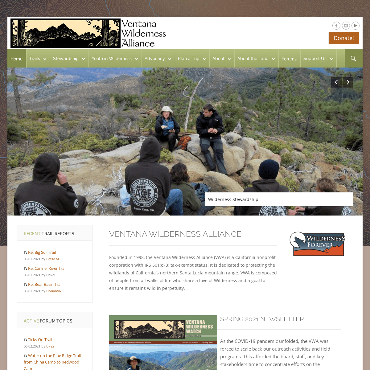
Wilderness Stewardship VENTANA WILDERNESS ALLIANCE Founded in 1998, the Ventana Wilderness Alliance (VWA) is a California nonprofit corporation with IRS 501(c)(3) tax-exempt status. It is dedicated to protecting the wildlands of California's northern Santa Lucia mountain range. VWA is composed of people from all walks of life who share a love of Wilderness and a goal to ensure it remains wild inperpetuity.
SPRING 2021 NEWSLETTER As the COVID-19 pandemic unfolded, the VWA was forced to scale back our outreach activities and field programs. This afforded the board, staff, and key stakeholders time to concentrate efforts on the completion of our Vision 2020 Strategic Plan, which will guide our actions over the next five years. This comprehensive document describes our goals for the next five years and how we will go about achieving them. This exhaustive and collaborative effort was facilitated by the VWA’s first Executive Director, Paul McFarland.Download a copy
Newsletter Archive
RECENT TRAIL REPORTSRe: Big Sur
Trail
06.01.2021 by Betsy MRe: Carmel
River Trail
06.01.2021 by DaveP
Re: Bear Basin
Trail
06.01.2021 by DorianVRACTIVE FORUM TOPICS
Ticks On Trail
06.02.2021 by BP22
Water on the Pine
Ridge Trail from China Camp to Redwood Cam06.01.2021 by BP22
What is below Pine
Falls?
05.27.2021 by Jim PowellCALENDAR OF EVENTS
WANT TO VOLUNTEER? JOIN THE VWA MEETUP GROUP HERE: VENTANA TRAILS FOREVER CAMPAIGN > For over a decade the Ventana Wilderness Alliance has led the > grassroots effort to protect the wilderness qualities of the Ventana > Region, along the Big Sur Coast. VWA volunteers also contribute > thousands of hours each year maintaining the public trails in the > Ventana back country. I support their conservation work and endorse > the Ventana Trails Forever campaign. - Robert Redford, Actor, Director, ConservationistFind Out More
Copyright © 1999-2021 Ventana Wilderness Alliance. Website By: TreeTop Web Design
* Privacy
* Terms
* Sitemap
* VWA Calendar
* Contact
Desktop Version
*
* Explore the Trails * Ventana Wilderness Trails * Silver Peak Wilderness Trails * State Parks Trails * Support the Trails*
* Trail Program
* Volunteer Wilderness Rangers * Archaeological Site Stewardship * Marijuana Grow Site Cleanups * Success Story: Willow Creek Restoration*
* Program Overview
* YiW Team
* YiW Outings
* SHE HIKES
* Leadership Initiatives * Become a YiW Partner * Become a YiW Funder*
* Accomplishments
* Wildfire Planning
* Milpitas Special Interest Area * Fort Hunter Liggett* NEPA & CEQA
* Grazing
*
* Trip Suggestions
* Maps & Books
* Weather, Road & Trail Conditions* Leave No Trace!
* Sykes Camp / Sykes Hot Springs * Arroyo Seco – Keep it Wild*
* Mission & Purpose
* Who We Are
* Newsletter
* Contact Us
* Careers & Jobs
*
* Natural Resources
* Cultural Resources * Double Cone Register Natural History Journal * Lost & Invisible Camps* Maps & Books
*
* Join/ Renew/ Donate* Legacy Giving
* 2020 Film FestivalDetails
1