4
More Annotations


6


4
Favourite Annotations


3


4
Text
U.S. TSUNAMI WARNING CENTERS Depth: 34 mi. Lat: 63.1° N Lon: 148.5° W. Location: 40 miles SE of Denali Park Hdqts., Alaska. Note: Times are local to your browser, unless otherwise indicated See the map or table below for more information. Alerts/Threats. Earthquakes. U.S. TSUNAMI WARNING CENTERS Depth: 7 mi. Lat: 42.3° N Lon: 126.1° W. Location: 145 miles NW of Eureka, California. Note: Times are local to your browser, unless otherwise indicated See the map or table below for more information. Alerts/Threats. Earthquakes. U.S. TSUNAMI WARNING CENTERS Magnitude: 4.7 Origin Time: 5/16/2021, 5:14:51 AM. Depth: 47 mi. Lat: 18.9° N Lon: 70.3° W. Location: ABOUT 160 MILES WEST OF ISLA MONA. Note: Times are local to your browser, unless otherwise indicated See the map or table below for more information. Alerts/Threats. U.S. TSUNAMI WARNING CENTERS Magnitude: 5.1 Origin Time: 10/20/2020, 1:37:13 AM. Depth: 11 mi. Lat: 54.7° N Lon: 159.7° W. Location: 55 miles SE of Sand Point, Alaska. Note: Times are local to your browser, unless otherwise indicated See the map or table below for more information. Alerts/Threats. U.S. TSUNAMI WARNING CENTERS Magnitude: 6.6 Origin Time: 4/30/2021, 6:27:26 PM. Depth: 35 mi. Lat: 38.1° N Lon: 141.8° E. Location: NEAR THE EAST COAST OF HONSHU JAPAN. Note: Times are local to your browser, unless otherwise indicated See the map or table below for more information. * Twitter
* Facebook
* Twitter
* Facebook
Alerts/Threats.
U.S. TSUNAMI WARNING CENTERS Location: 60 miles NE of Seward, Alaska. Note: Times are local to your browser, unless otherwise indicated See the map or table below for more information. Alerts/Threats. Earthquakes. Previous 40 Messages. Observations. Forecasts. U.S. TSUNAMI WARNING CENTERS Magnitude: 7.7 Origin Time: 2/10/2021, 5:19:56 AM. Depth: 21 mi. Lat: 23.1° S Lon: 171.5° E. Location: in the Loyalty Islands region. Note: Times are local to your browser, unless otherwise indicated See the map or table below for more information. Alerts/Threats. U.S. TSUNAMI WARNING CENTERS Depth: 34 mi. Lat: 63.1° N Lon: 148.5° W. Location: 40 miles SE of Denali Park Hdqts., Alaska. Note: Times are local to your browser, unless otherwise indicated See the map or table below for more information. Alerts/Threats. Earthquakes. U.S. TSUNAMI WARNING CENTERS Depth: 7 mi. Lat: 42.3° N Lon: 126.1° W. Location: 145 miles NW of Eureka, California. Note: Times are local to your browser, unless otherwise indicated See the map or table below for more information. Alerts/Threats. Earthquakes. U.S. TSUNAMI WARNING CENTERS Magnitude: 4.7 Origin Time: 5/16/2021, 5:14:51 AM. Depth: 47 mi. Lat: 18.9° N Lon: 70.3° W. Location: ABOUT 160 MILES WEST OF ISLA MONA. Note: Times are local to your browser, unless otherwise indicated See the map or table below for more information. Alerts/Threats. U.S. TSUNAMI WARNING CENTERS Magnitude: 5.1 Origin Time: 10/20/2020, 1:37:13 AM. Depth: 11 mi. Lat: 54.7° N Lon: 159.7° W. Location: 55 miles SE of Sand Point, Alaska. Note: Times are local to your browser, unless otherwise indicated See the map or table below for more information. Alerts/Threats. U.S. TSUNAMI WARNING CENTERS Magnitude: 6.6 Origin Time: 4/30/2021, 6:27:26 PM. Depth: 35 mi. Lat: 38.1° N Lon: 141.8° E. Location: NEAR THE EAST COAST OF HONSHU JAPAN. Note: Times are local to your browser, unless otherwise indicated See the map or table below for more information.Alerts/Threats.
U.S. TSUNAMI WARNING CENTERS Location: 60 miles NE of Seward, Alaska. Note: Times are local to your browser, unless otherwise indicated See the map or table below for more information. Alerts/Threats. Earthquakes. Previous 40 Messages. Observations. Forecasts. U.S. TSUNAMI WARNING CENTERS Magnitude: 7.7 Origin Time: 2/10/2021, 5:19:56 AM. Depth: 21 mi. Lat: 23.1° S Lon: 171.5° E. Location: in the Loyalty Islands region. Note: Times are local to your browser, unless otherwise indicated See the map or table below for more information. Alerts/Threats. U.S. TSUNAMI WARNING CENTERS Depth: 34 mi. Lat: 63.1° N Lon: 148.5° W. Location: 40 miles SE of Denali Park Hdqts., Alaska. Note: Times are local to your browser, unless otherwise indicated See the map or table below for more information. Alerts/Threats. Earthquakes. U.S. TSUNAMI WARNING CENTERS Your official U.S. government weather forecasts, warnings, meteorological products for forecasting the weather, tsunami hazards, and information about seismology. U.S. TSUNAMI WARNING CENTERS Magnitude: 6.6 Origin Time: 4/30/2021, 6:27:26 PM. Depth: 35 mi. Lat: 38.1° N Lon: 141.8° E. Location: NEAR THE EAST COAST OF HONSHU JAPAN. Note: Times are local to your browser, unless otherwise indicated See the map or table below for more information.Alerts/Threats.
U.S. TSUNAMI WARNING CENTERS Location: 110 miles SW of Haines, Alaska. Note: Times are local to your browser, unless otherwise indicated See the map or table below for more information. Alerts/Threats. Earthquakes. Previous 40 Messages. Observations. Forecasts. U.S. TSUNAMI WARNING CENTERS Depth: 90 mi. Lat: 51.7° N Lon: 178.3° E. Location: 30 miles NW of Amchitka, Alaska. Note: Times are local to your browser, unless otherwise indicated See the map or table below for more information. Alerts/Threats. Earthquakes. U.S. TSUNAMI WARNING CENTERS Magnitude: 6.5 Origin Time: 4/2/2021, 6:16:36 PM. Depth: 6 mi. Lat: 58.2° S Lon: 8.2° W. Location: in the southwestern Atlantic Ocean. Note: Times are local to your browser, unless otherwise indicated See the map or table below for more information. Alerts/Threats. U.S. TSUNAMI WARNING CENTERS Magnitude: 4.1 Origin Time: 4/3/2021, 2:15:22 PM. Depth: 5 mi. Lat: 19.2° N Lon: 155.5° W. Location: ON THE SOUTHEASTERN FLANK OF MAUNA LOA. Note: Times are local to your browser, unless otherwise indicated See the map or table below for more information. Alerts/Threats. U.S. TSUNAMI WARNING CENTERS Message Subscriptions: The National Tsunami Warning Center (NTWC) serves the continental United States, Alaska and Canada. The Pacific Tsunami Warning Center (PTWC) directly serves the Hawaiian Islands, the U.S. Pacific and Caribbean territories, and the British Virgin Islands and is the primary international forecast center for the warning systems of the Intergovernmental Oceanographic U.S. TSUNAMI WARNING CENTERS Magnitude: 6.8 Origin Time: 9/18/2020, 2:44:00 PM. Depth: 21 mi. Lat: 1.1° N Lon: 27° W. Location: near the central Mid-Atlantic Ridge. Note: Times are local to your browser, unless otherwise indicated See the map or table below for more information. Alerts/Threats. TSUNAMI EVENT OBSERVATIONS Location Country Lat Lon Obs Max Time (UTC) Obs Height Fcst Height Forecast Arrival Time (UTC) TWC; DART 46413: United States: 48 ° N: 174.2 ° W : n/a : 03-05-2021 05:35:00: NTWC: DART 46408: UnitedStates
U.S. TSUNAMI WARNING CENTERSEXERCISESNOAA TSUNAMI PROGRAMPREVIOUS MESSAGESMESSAGE SUBSCRIPTIONSMESSAGE DEFINITIONS Your official U.S. government weather forecasts, warnings, meteorological products for forecasting the weather, tsunami hazards, and information about seismology. U.S. TSUNAMI WARNING CENTERS Depth: 34 mi. Lat: 63.1° N Lon: 148.5° W. Location: 40 miles SE of Denali Park Hdqts., Alaska. Note: Times are local to your browser, unless otherwise indicated See the map or table below for more information. Alerts/Threats. Earthquakes. U.S. TSUNAMI WARNING CENTERS Magnitude: 4.7 Origin Time: 5/16/2021, 5:14:51 AM. Depth: 47 mi. Lat: 18.9° N Lon: 70.3° W. Location: ABOUT 160 MILES WEST OF ISLA MONA. Note: Times are local to your browser, unless otherwise indicated See the map or table below for more information. Alerts/Threats. U.S. TSUNAMI WARNING CENTERS Location: 60 miles NE of Seward, Alaska. Note: Times are local to your browser, unless otherwise indicated See the map or table below for more information. Alerts/Threats. Earthquakes. Previous 40 Messages. Observations. Forecasts. U.S. TSUNAMI WARNING CENTERS National Tsunami Warning Center (NTWC) The Palmer Observatory, under the auspices of the Coast and Geodetic Survey, was established in Palmer, Alaska in 1967 as a direct result of the great Alaskan earthquake that occurred in Prince William Sound on March 27, 1964. This earthquake alerted State and Federal officials that a facilitywas
U.S. TSUNAMI WARNING CENTERS Magnitude: 7.7 Origin Time: 2/10/2021, 5:19:56 AM. Depth: 21 mi. Lat: 23.1° S Lon: 171.5° E. Location: in the Loyalty Islands region. Note: Times are local to your browser, unless otherwise indicated See the map or table below for more information. Alerts/Threats. U.S. TSUNAMI WARNING CENTERS Message Subscriptions: The National Tsunami Warning Center (NTWC) serves the continental United States, Alaska and Canada. The Pacific Tsunami Warning Center (PTWC) directly serves the Hawaiian Islands, the U.S. Pacific and Caribbean territories, and the British Virgin Islands and is the primary international forecast center for the warning systems of the Intergovernmental Oceanographic U.S. TSUNAMI WARNING CENTERS Magnitude: 6.6 Origin Time: 2/2/2021, 9:23:42 PM. Depth: 6 mi. Lat: 36.4° S Lon: 98.1° W. Location: SOUTHEAST OF EASTER ISLAND. Note: Times are local to your browser, unless otherwise indicated See the map or table below for more information. Alerts/Threats. U.S. TSUNAMI WARNING CENTERSEXERCISESNOAA TSUNAMI PROGRAMPREVIOUS MESSAGESMESSAGE SUBSCRIPTIONSMESSAGE DEFINITIONS Your official U.S. government weather forecasts, warnings, meteorological products for forecasting the weather, tsunami hazards, and information about seismology. U.S. TSUNAMI WARNING CENTERS Depth: 34 mi. Lat: 63.1° N Lon: 148.5° W. Location: 40 miles SE of Denali Park Hdqts., Alaska. Note: Times are local to your browser, unless otherwise indicated See the map or table below for more information. Alerts/Threats. Earthquakes. U.S. TSUNAMI WARNING CENTERS Magnitude: 4.7 Origin Time: 5/16/2021, 5:14:51 AM. Depth: 47 mi. Lat: 18.9° N Lon: 70.3° W. Location: ABOUT 160 MILES WEST OF ISLA MONA. Note: Times are local to your browser, unless otherwise indicated See the map or table below for more information. Alerts/Threats. U.S. TSUNAMI WARNING CENTERS Location: 60 miles NE of Seward, Alaska. Note: Times are local to your browser, unless otherwise indicated See the map or table below for more information. Alerts/Threats. Earthquakes. Previous 40 Messages. Observations. Forecasts. U.S. TSUNAMI WARNING CENTERS National Tsunami Warning Center (NTWC) The Palmer Observatory, under the auspices of the Coast and Geodetic Survey, was established in Palmer, Alaska in 1967 as a direct result of the great Alaskan earthquake that occurred in Prince William Sound on March 27, 1964. This earthquake alerted State and Federal officials that a facilitywas
U.S. TSUNAMI WARNING CENTERS Magnitude: 7.7 Origin Time: 2/10/2021, 5:19:56 AM. Depth: 21 mi. Lat: 23.1° S Lon: 171.5° E. Location: in the Loyalty Islands region. Note: Times are local to your browser, unless otherwise indicated See the map or table below for more information. Alerts/Threats. U.S. TSUNAMI WARNING CENTERS Message Subscriptions: The National Tsunami Warning Center (NTWC) serves the continental United States, Alaska and Canada. The Pacific Tsunami Warning Center (PTWC) directly serves the Hawaiian Islands, the U.S. Pacific and Caribbean territories, and the British Virgin Islands and is the primary international forecast center for the warning systems of the Intergovernmental Oceanographic U.S. TSUNAMI WARNING CENTERS Magnitude: 6.6 Origin Time: 2/2/2021, 9:23:42 PM. Depth: 6 mi. Lat: 36.4° S Lon: 98.1° W. Location: SOUTHEAST OF EASTER ISLAND. Note: Times are local to your browser, unless otherwise indicated See the map or table below for more information. Alerts/Threats. U.S. TSUNAMI WARNING CENTERS Your official U.S. government weather forecasts, warnings, meteorological products for forecasting the weather, tsunami hazards, and information about seismology. U.S. TSUNAMI WARNING CENTERS Message Subscriptions: The National Tsunami Warning Center (NTWC) serves the continental United States, Alaska and Canada. The Pacific Tsunami Warning Center (PTWC) directly serves the Hawaiian Islands, the U.S. Pacific and Caribbean territories, and the British Virgin Islands and is the primary international forecast center for the warning systems of the Intergovernmental Oceanographic U.S. TSUNAMI WARNING CENTERS Location: 110 miles SW of Haines, Alaska. Note: Times are local to your browser, unless otherwise indicated See the map or table below for more information. Alerts/Threats. Earthquakes. Previous 40 Messages. Observations. Forecasts. U.S. TSUNAMI WARNING CENTERS Magnitude: 6.5 Origin Time: 4/2/2021, 6:16:36 PM. Depth: 6 mi. Lat: 58.2° S Lon: 8.2° W. Location: in the southwestern Atlantic Ocean. Note: Times are local to your browser, unless otherwise indicated See the map or table below for more information. Alerts/Threats. U.S. TSUNAMI WARNING CENTERS Magnitude: 4.1 Origin Time: 4/3/2021, 2:15:22 PM. Depth: 5 mi. Lat: 19.2° N Lon: 155.5° W. Location: ON THE SOUTHEASTERN FLANK OF MAUNA LOA. Note: Times are local to your browser, unless otherwise indicated See the map or table below for more information. Alerts/Threats. U.S. TSUNAMI WARNING CENTERS Magnitude: 6.6 Origin Time: 2/2/2021, 9:23:42 PM. Depth: 6 mi. Lat: 36.4° S Lon: 98.1° W. Location: SOUTHEAST OF EASTER ISLAND. Note: Times are local to your browser, unless otherwise indicated See the map or table below for more information. Alerts/Threats. U.S. TSUNAMI WARNING CENTERS Magnitude: 5.1 Origin Time: 10/20/2020, 1:37:13 AM. Depth: 11 mi. Lat: 54.7° N Lon: 159.7° W. Location: 55 miles SE of Sand Point, Alaska. Note: Times are local to your browser, unless otherwise indicated See the map or table below for more information. Alerts/Threats. U.S. TSUNAMI WARNING CENTERS Earthquake: Magnitude: 7.2 Origin Time: 3/20/2021, 2:09:00 AM. Depth: 37 mi. Lat: 38.4° N Lon: 141.7° E. Location: NEAR THE EAST COAST OF HONSHU JAPAN. Note: Times are local to your browser, unless otherwise indicated See the map or table below for more information.Alerts/Threats.
U.S. TSUNAMI WARNING CENTERS NOAA’s Pacific Tsunami Warning Center was established in response to this tsunami. November 1, 1755 Lisbon, Portugal (animation)—A magnitude 8.5 (estimated) earthquake in the Atlantic Ocean generated a tsunami that affected the coasts of Portugal, Spain, North Africa, andthe Caribbean.
U.S. TSUNAMI WARNING CENTERS The U.S. Tsunami Warning Centers issue tsunami messages to notify emergency managers, the public, and other partners about the potential for a tsunami following a possible tsunami-generating event. To provide messages as early as possible, the warning centers use preset criteria based on preliminary earthquake information, before a tsunamiis
U.S. TSUNAMI WARNING CENTERSTHE PACIFIC TSUNAMI WARNING CENTERTHE PACIFIC TSUNAMI WARNING CENTERTSUNAMI WARNING TODAYALASKA TSUNAMI WARNING CENTER PALMERNATIONAL TSUNAMI WARNING CENTER NWSNATIONAL WEATHER SERVICE TSUNAMI WARNING Your official U.S. government weather forecasts, warnings, meteorological products for forecasting the weather, tsunami hazards, and information about seismology. U.S. TSUNAMI WARNING CENTERSEARTHQUAKE WARNING TODAYNEW EARTHQUAKEWARNING
Your official U.S. government weather forecasts, warnings, meteorological products for forecasting the weather, tsunami hazards, and information about seismology. U.S. TSUNAMI WARNING CENTERS Message Subscriptions: The National Tsunami Warning Center (NTWC) serves the continental United States, Alaska and Canada. The Pacific Tsunami Warning Center (PTWC) directly serves the Hawaiian Islands, the U.S. Pacific and Caribbean territories, and the British Virgin Islands and is the primary international forecast center for the warning systems of the Intergovernmental Oceanographic U.S. TSUNAMI WARNING CENTERS Tsunami Warning Center History Pacific Tsunami Warning Center National Tsunami Warning Center Pacific Tsunami Warning Center (PTWC) The era of tsunami warnings began in the United States with Thomas Jaggar's (founder of the Hawaiian Volcano Observatory (HVO)) attempt to warn the Hilo harbormaster of the possibility of a tsunami generated by the 1923 Kamchatka earthquake. U.S. TSUNAMI WARNING CENTERS Travel Time Map: When a tsunami is expected, the Travel Time Map shows expected travel time (in hours) from the tsunami’s source to locations throughout the ocean basin, when available. Contours on the map represent 30-minute intervals. Each change in color shade of a contour line is a one-hour mark. See example below. U.S. TSUNAMI WARNING CENTERSTHE PACIFIC TSUNAMI WARNING CENTERTHE PACIFIC TSUNAMI WARNING CENTERTSUNAMI WARNING TODAYALASKA TSUNAMI WARNING CENTER PALMERNATIONAL TSUNAMI WARNING CENTER NWSNATIONAL WEATHER SERVICE TSUNAMI WARNING Your official U.S. government weather forecasts, warnings, meteorological products for forecasting the weather, tsunami hazards, and information about seismology. U.S. TSUNAMI WARNING CENTERSEARTHQUAKE WARNING TODAYNEW EARTHQUAKEWARNING
Your official U.S. government weather forecasts, warnings, meteorological products for forecasting the weather, tsunami hazards, and information about seismology. U.S. TSUNAMI WARNING CENTERS Message Subscriptions: The National Tsunami Warning Center (NTWC) serves the continental United States, Alaska and Canada. The Pacific Tsunami Warning Center (PTWC) directly serves the Hawaiian Islands, the U.S. Pacific and Caribbean territories, and the British Virgin Islands and is the primary international forecast center for the warning systems of the Intergovernmental Oceanographic U.S. TSUNAMI WARNING CENTERS Tsunami Warning Center History Pacific Tsunami Warning Center National Tsunami Warning Center Pacific Tsunami Warning Center (PTWC) The era of tsunami warnings began in the United States with Thomas Jaggar's (founder of the Hawaiian Volcano Observatory (HVO)) attempt to warn the Hilo harbormaster of the possibility of a tsunami generated by the 1923 Kamchatka earthquake. U.S. TSUNAMI WARNING CENTERS Travel Time Map: When a tsunami is expected, the Travel Time Map shows expected travel time (in hours) from the tsunami’s source to locations throughout the ocean basin, when available. Contours on the map represent 30-minute intervals. Each change in color shade of a contour line is a one-hour mark. See example below. U.S. TSUNAMI WARNING CENTERS Magnitude: 4 Origin Time: 6/2/2021, 9:44:32 PM. Depth: 6 mi. Lat: 18.9° N Lon: 155.2° W. Location: AT LOIHI SEAMOUNT SOUTH OF THE BIG ISLAND. Note: Times are local to your browser, unless otherwise indicated See the map or table below for more information.Alerts/Threats.
U.S. TSUNAMI WARNING CENTERS Travel Time Map: When a tsunami is expected, the Travel Time Map shows expected travel time (in hours) from the tsunami’s source to locations throughout the ocean basin, when available. Contours on the map represent 30-minute intervals. Each change in color shade of a contour line is a one-hour mark. See example below. U.S. TSUNAMI WARNING CENTERS Magnitude: 7.7 Origin Time: 2/10/2021, 5:19:56 AM. Depth: 21 mi. Lat: 23.1° S Lon: 171.5° E. Location: in the Loyalty Islands region. Note: Times are local to your browser, unless otherwise indicated See the map or table below for more information. Alerts/Threats. U.S. TSUNAMI WARNING CENTERS Magnitude: 6.6 Origin Time: 2/2/2021, 9:23:42 PM. Depth: 6 mi. Lat: 36.4° S Lon: 98.1° W. Location: SOUTHEAST OF EASTER ISLAND. Note: Times are local to your browser, unless otherwise indicated See the map or table below for more information. Alerts/Threats. U.S. TSUNAMI WARNING CENTERS Magnitude: 5.1 Origin Time: 10/20/2020, 1:37:13 AM. Depth: 11 mi. Lat: 54.7° N Lon: 159.7° W. Location: 55 miles SE of Sand Point, Alaska. Note: Times are local to your browser, unless otherwise indicated See the map or table below for more information. Alerts/Threats. U.S. TSUNAMI WARNING CENTERS 149.9° W. 35 miles SW of Palmer, Alaska. AK/BC/US West Coast Informational #1. Select Resource Obs/Forecasts TEX File CAP File English Message 1 Spanish Message 1. 04-27-2021 17:29:45. U.S. TSUNAMI WARNING CENTERS Depth: 34 mi. Lat: 63.1° N Lon: 148.5° W. Location: 40 miles SE of Denali Park Hdqts., Alaska. Note: Times are local to your browser, unless otherwise indicated See the map or table below for more information. Alerts/Threats. Earthquakes. U.S. TSUNAMI WARNING CENTERS Your official U.S. government weather forecasts, warnings, meteorological products for forecasting the weather, tsunami hazards, and information about seismology. U.S. TSUNAMI WARNING CENTERS Location: 30 miles E of Monterey, California. Note: Times are local to your browser, unless otherwise indicated See the map or table below for more information. Alerts/Threats. Earthquakes. Previous 40 Messages. Observations. Forecasts. U.S. TSUNAMI WARNING CENTERS NOAA’s Pacific Tsunami Warning Center was established in response to this tsunami. November 1, 1755 Lisbon, Portugal (animation)—A magnitude 8.5 (estimated) earthquake in the Atlantic Ocean generated a tsunami that affected the coasts of Portugal, Spain, North Africa, andthe Caribbean.
United States Department of Commerce NOAA / National Weather Service U.S. Tsunami Warning SystemHome
News
Organization
Search for: NWS All NOAA*
-------------------------* Products/Messages
* Previous Messages
* Message Subscriptions * Message Definitions* Product List
* Warning Criteria
* Atlantic
* Pacific
* CAP-TSU
* Tsunami Event XML (TEX) -------------------------* Tsunami Data
* Water-Level Data
* DART Systems
* NOAA Coastal Water-Level Stations* International
* Historical Tsunamis* Recent Tsunamis
------------------------- * Education/Outreach* Tsunami FAQ
* Tsunami Safety
* Tsunami Education and Outreach -------------------------* Exercises
------------------------- * NOAA Tsunami Program -------------------------* TsunamiReady
------------------------- * International Tsunami Information Center ------------------------- * Caribbean Tsunami Warning Program -------------------------* Tsunami Research
------------------------- * National Tsunami Hazard Mitigation Program ------------------------- * IOC/UNESCO Tsunami Program ------------------------- * Tsunami Warning Centers * About the Warning Centers* Warning Guides
* Canada/US except Hawaii* American Samoa
* Guam/CNMI
* Puerto Rico/Virgin Islands * International Pacific * International Caribbean * Visit a Warning Center -------------------------* Follow Us!
* National Tsunami Warning Center* Atom
* CAP File
* Pacific Tsunami Warning Center* YouTube
* Atom
* CAP File
Please enable JavaScript. This page needs Javascript to functionproperly.
Event Magnitude 5.9 (Mwp) Depth 11 (kilometers) Lat: 42.302 Lon: -126.102 Origin Time: 2021-06-04T08:17:01 UTCview bulletin
-------------------------INFORMATION
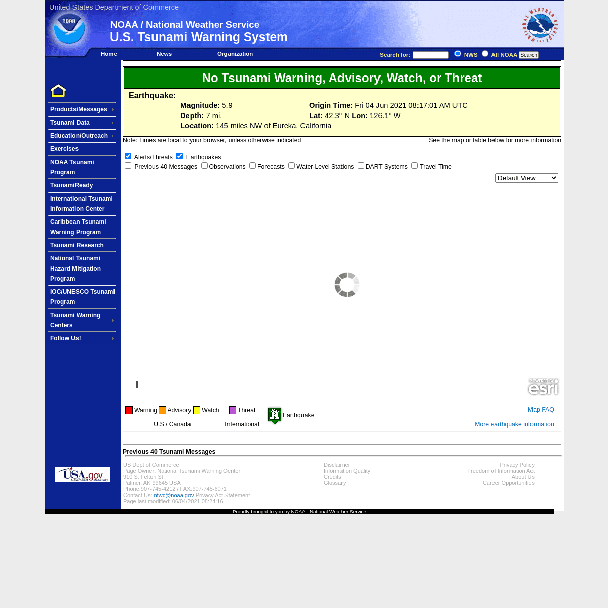
This is a Tsunami Information Statement. No Tsunami Warning, Advisory, Watch, or Threat There is No Tsunami Warning, Advisory, Watch, or Threat in effect.EARTHQUAKE:
MAGNITUDE: 5.9 ORIGIN TIME: Fri 04 Jun 2021 08:17:01 AM UTC DEPTH: 7 mi.LAT: 42.3° N LON: 126.1° W LOCATION: 145 miles NW of Eureka, California Note: Times are local to your browser, unless otherwise indicatedSee the map or table below formore information
Alerts/Threats
Earthquakes
Previous 40 MessagesObservations
Forecasts
Water-Level StationsDART Systems
Travel Time
Auto Update min
Topographic
Loading Earthquake LayerLoading Alert Layer
Earthquake Layer failed to load Alerts/Threats Layer failed to load Default View Alaska Hawaii Guam/CNMI American Samoa Caribbean North America South America Earthstar Geographics |Zoom to
+
–
3000km
2000mi
Warning
Advisory
Watch
-------------------------U.S / Canada
Threat
-------------------------International
Earthquake
Map FAQ
More earthquake information ------------------------- ------------------------- PREVIOUS 40 TSUNAMI MESSAGESISSUED *
ORIGIN TIME *
MAG
DEPTH
LAT
LON
LOCATION
MESSAGES
ADDITIONAL RESOURCES **06-04-2021 08:23:37
06-04-2021 08:17:01
5.9
7 Mi.
42.3° N
126.1° W
145 miles NW of Eureka, California AK/BC/US West Coast Informational #1 Select Resource Obs/Forecasts TEX File CAP File English Message 1Spanish Message 1
06-04-2021 07:57:29
06-04-2021 07:52:43
5.8
7 Mi.
42.3° N
126.1° W
145 miles NW of Eureka, California AK/BC/US West Coast Informational #1 Select Resource Obs/Forecasts TEX File CAP File English Message 1Spanish Message 1
06-03-2021 04:48:28
06-03-2021 04:44:32
4
6 Mi.
18.9° N
155.2° W
AT LOIHI SEAMOUNT SOUTH OF THE BIG ISLAND Hawaii Informational #1 Select Resource Obs/Forecasts TEX File CAP File English Message 105-31-2021 07:03:19
05-31-2021 06:59:55
5.8
37 Mi.
62.4° N
148.2° W
60 miles E of Talkeetna, Alaska AK/BC/US West Coast Informational #1 Select Resource Obs/Forecasts TEX File CAP File English Message 1Spanish Message 1
05-21-2021 22:23:24
05-21-2021 22:13:15
6.8
6 Mi.
16.4° S
177° W
FIJI REGION
Guam/CNMI Informational #1 Select Resource Obs/Forecasts TEX File CAP File English Message 105-21-2021 22:23:01
05-21-2021 22:13:15
6.8
6 Mi.
16.4° S
177° W
FIJI REGION
Hawaii Informational #1 Select Resource Obs/Forecasts TEX File CAP File English Message 105-21-2021 22:21:40
05-21-2021 22:13:15
6.8
6 Mi.
16.4° S
177° W
FIJI REGION
Non-US/Canada Pacific Informational #1 Select Resource Obs/Forecasts TEX File CAP File English Message 105-21-2021 22:21:01
05-21-2021 22:13:15
6.8
6 Mi.
16.4° S
177° W
FIJI REGION
American Samoa Informational #1 Select Resource Obs/Forecasts TEX File CAP File English Message 105-17-2021 20:33:03
05-17-2021 20:25:05
5
9 Mi.
50.9° N
179.2° E
45 miles S of Amchitka, Alaska AK/BC/US West Coast Informational #1 Select Resource Obs/Forecasts TEX File CAP File English Message 1Spanish Message 1
05-16-2021 12:24:31
05-16-2021 12:14:51
4.7
47 Mi.
18.9° N
70.3° W
ABOUT 160 MILES WEST OF ISLA MONA PR/Virgin Isl. Informational #1 Select Resource Obs/Forecasts TEX File CAP File English Message 1Spanish Message 1
05-12-2021 22:09:41
05-12-2021 22:00:30
5.1
25 Mi.
51.4° N
175.9° E
65 miles S of Buldir I., Alaska AK/BC/US West Coast Informational #1 Select Resource Obs/Forecasts TEX File CAP File English Message 1Spanish Message 1
05-01-2021 15:28:19
05-01-2021 15:23:23
4.7
16 Mi.
58.3° N
137.9° W
110 miles SW of Haines, Alaska AK/BC/US West Coast Informational #1 Select Resource Obs/Forecasts TEX File CAP File English Message 1Spanish Message 1
05-01-2021 01:36:13
05-01-2021 01:27:30
6.6
35 Mi.
38.1° N
141.8° E
near the east coast of Honshu, Japan AK/BC/US West Coast Informational #1 Select Resource Obs/Forecasts Travel Time MapTEX File CAP File English Message 1 Spanish Message 105-01-2021 01:35:30
05-01-2021 01:27:30
6.6
35 Mi.
38.1° N
141.8° E
NEAR THE EAST COAST OF HONSHU JAPAN Guam/CNMI Informational #1 Select Resource Obs/Forecasts TEX File CAP File English Message 105-01-2021 01:35:18
05-01-2021 01:27:30
6.6
35 Mi.
38.1° N
141.8° E
NEAR THE EAST COAST OF HONSHU JAPAN American Samoa Informational #1 Select Resource Obs/Forecasts TEX File CAP File English Message 105-01-2021 01:34:32
05-01-2021 01:27:30
6.6
35 Mi.
38.1° N
141.8° E
NEAR THE EAST COAST OF HONSHU JAPAN Hawaii Informational #1 Select Resource Obs/Forecasts TEX File CAP File English Message 105-01-2021 01:34:10
05-01-2021 01:27:30
6.6
35 Mi.
38.1° N
141.8° E
NEAR THE EAST COAST OF HONSHU JAPAN Non-US/Canada Pacific Informational #1 Select Resource Obs/Forecasts TEX File CAP File English Message 104-29-2021 11:02:42
04-29-2021 10:58:38
5.4
7 Mi.
44° N
128° W
off the coast of Oregon AK/BC/US West Coast Informational #1 Select Resource Obs/Forecasts TEX File CAP File English Message 1Spanish Message 1
04-29-2021 10:40:56
04-29-2021 10:35:51
5.2
7 Mi.
44° N
128.1° W
off the coast of Oregon AK/BC/US West Coast Informational #1 Select Resource Obs/Forecasts TEX File CAP File English Message 1Spanish Message 1
04-28-2021 21:45:30
04-28-2021 21:36:39
4.6
9 Mi.
44° N
126.9° W
195 miles W of Eugene, Oregon AK/BC/US West Coast Informational #1 Select Resource Obs/Forecasts TEX File CAP File English Message 1Spanish Message 1
04-27-2021 17:58:11
04-27-2021 17:54:35
4.7
16 Mi.
61.3° N
149.9° W
35 miles SW of Palmer, Alaska AK/BC/US West Coast Informational #1 Select Resource Obs/Forecasts TEX File CAP File English Message 1Spanish Message 1
04-27-2021 17:29:45
04-27-2021 17:25:59
4.2
2 Mi.
60.3° N
147.8° W
60 miles NE of Seward, Alaska AK/BC/US West Coast Informational #1 Select Resource Obs/Forecasts TEX File CAP File English Message 1Spanish Message 1
04-24-2021 09:36:41
04-24-2021 09:30:42
5.3
90 Mi.
51.7° N
178.3° E
30 miles NW of Amchitka, Alaska AK/BC/US West Coast Informational #1 Select Resource Obs/Forecasts TEX File CAP File English Message 1Spanish Message 1
04-15-2021 08:44:28
04-15-2021 08:33:42
5.4
20 Mi.
53.4° N
171.6° E
75 miles NW of Attu I., Alaska AK/BC/US West Coast Informational #1 Select Resource Obs/Forecasts TEX File CAP File English Message 1Spanish Message 1
04-08-2021 17:13:34
04-08-2021 17:10:19
5.7
34 Mi.
63.1° N
148.5° W
40 miles SE of Denali Park Hdqts., Alaska AK/BC/US West Coast Informational #1 Select Resource Obs/Forecasts TEX File CAP File English Message 1Spanish Message 1
04-05-2021 11:46:13
04-05-2021 11:44:01
4.3
5 Mi.
33.9° N
118.3° W
100 miles SW of Barstow, California AK/BC/US West Coast Informational #1 Select Resource Obs/Forecasts TEX File CAP File English Message 1Spanish Message 1
04-03-2021 21:18:39
04-03-2021 21:15:22
4.1
5 Mi.
19.2° N
155.5° W
ON THE SOUTHEASTERN FLANK OF MAUNA LOA Hawaii Informational #1 Select Resource Obs/Forecasts TEX File CAP File English Message 104-03-2021 01:36:56
04-03-2021 01:16:41
6.5
6 Mi.
58.2° S
8.2° W
EAST OF THE SOUTH SANDWICH ISLANDS PR/Virgin Isl. Informational #1 Select Resource Obs/Forecasts TEX File CAP File English Message 1Spanish Message 1
04-03-2021 01:34:33
04-03-2021 01:16:41
6.5
6 Mi.
58.2° S
8.2° W
in the southwestern Atlantic Ocean GoM/East Coast Info #1 Select Resource Obs/Forecasts Travel Time MapTEX File CAP File English Message 1 Spanish Message 104-03-2021 01:33:23
04-03-2021 01:16:41
6.5
6 Mi.
58.2° S
8.2° W
EAST OF THE SOUTH SANDWICH ISLANDS Non-US Caribe Informational #1 Select Resource Obs/Forecasts TEX File CAP File English Message 104-01-2021 10:19:56
04-01-2021 09:56:37
6.6
65 Mi.
30.1° S
176.4° W
KERMADEC ISLANDS REGION Guam/CNMI Informational #1 Select Resource Obs/Forecasts TEX File CAP File English Message 104-01-2021 10:12:23
04-01-2021 09:56:37
6.6
65 Mi.
30.1° S
176.4° W
KERMADEC ISLANDS REGION American Samoa Informational #1 Select Resource Obs/Forecasts TEX File CAP File English Message 104-01-2021 10:09:53
04-01-2021 09:56:37
6.6
65 Mi.
30.1° S
176.4° W
KERMADEC ISLANDS REGION Hawaii Informational #1 Select Resource Obs/Forecasts TEX File CAP File English Message 104-01-2021 10:09:33
04-01-2021 09:56:37
6.6
65 Mi.
30.1° S
176.4° W
in the Kermadec Islands region, north of New Zealand AK/BC/US West Coast Informational #1 Select Resource Obs/Forecasts Travel Time MapTEX File CAP File English Message 1 Spanish Message 104-01-2021 10:07:06
04-01-2021 09:56:37
6.6
65 Mi.
30.1° S
176.4° W
KERMADEC ISLANDS REGION Non-US/Canada Pacific Informational #1 Select Resource Obs/Forecasts TEX File CAP File English Message 103-30-2021 00:14:35
03-30-2021 00:06:09
5.4
21 Mi.
72.3° N
133.1° W
in the Beaufort Sea, north of Alaska AK/BC/US West Coast Informational #1 Select Resource Obs/Forecasts TEX File CAP File English Message 1Spanish Message 1
03-22-2021 17:44:55
03-22-2021 17:41:46
4.4
84 Mi.
59.8° N
153.4° W
55 miles E of Iliamna, Alaska AK/BC/US West Coast Informational #1 Select Resource Obs/Forecasts TEX File CAP File English Message 1Spanish Message 1
03-20-2021 10:25:07
03-20-2021 09:09:00
7.2
37 Mi.
38.4° N
141.7° E
NEAR THE EAST COAST OF HONSHU JAPAN Non-US/Canada Pacific Threat #2 Select Resource Obs/Forecasts TEX File CAP File English Message 203-20-2021 09:26:25
03-20-2021 09:09:00
7.2
37 Mi.
38.4° N
141.7° E
NEAR THE EAST COAST OF HONSHU JAPAN Guam/CNMI Informational #1 Select Resource Obs/Forecasts TEX File CAP File English Message 103-20-2021 09:25:10
03-20-2021 09:09:00
7.2
37 Mi.
38.4° N
141.7° E
NEAR THE EAST COAST OF HONSHU JAPAN American Samoa Informational #1 Select Resource Obs/Forecasts TEX File CAP File English Message 1 * Dates/Times in table are UTC ** Pop-up blockers may need to be disabled to access AdditionalResources
-------------------------US Dept of Commerce
Page Owner: National Tsunami Warning Center910 S. Felton St.
Palmer, AK 99645 USA Phone:907-745-4212 / FAX:907-745-6071 Contact Us: ntwc@noaa.gov Privacy Act Statement Page last modified: 06/04/2021 08:24:16* Disclaimer
* Information Quality* Credits
* Glossary
* Privacy Policy
* Freedom of Information Act* About Us
* Career Opportunities Proudly brought to you by NOAA - National Weather ServiceDetails
1