2
More Annotations


5


2
Favourite Annotations


6


6
Text
SPACE DATA – RELIABLE AND SECURE WIRELESS COMMUNICATIONSABOUT USGOVERNMENTSPECTRUMINDUSTRIESRESOURCESBOARD OF DIRECTORS SPACE DATA. SkySite® Platform. Stratospheric platform for cost-effective communications. High-altitude balloon-borne transceivers launch every 8 to 12 hours. Launches in 20 minutes and rises to 60000-100000 ft. altitude. Communications in remote areas with coverage circle >400 miles. GET STARTED WITH SkySite®. UTILITIES – SPACE DATA A remote terminal unit (RTU) is a microprocessor-controlled electronic device that interfaces objects in the physical world to a Supervisory Control and Data Acquisition (SCADA) system by transmitting telemetry data to a master system, and by using messages from the master supervisory system to control connected objects. ABOUT US – SPACE DATA About Us. Space Data delivers wireless services and solutions for commercial and government users in locations and geographies that are not served or are poorly served by existing wireless technologies and service providers. Using balloon-borne technologies, our SkySite ® and SkySat ™ stratospheric wireless communications platforms can be MILITARY – SPACE DATA Currently in use by the U.S. military, Space Data’s SkySat™ stratospheric platform extends the range of standard issue military two-way radios from 10 miles to nearly 500 miles. The balloon-borne system is easily transportable and can be launched by a one- or
two-man team.
SPECTRUM – SPACE DATA Space Data’s 900 MHz NPCS, Private, Licensed Spectrum Provides Guaranteed Scalable, Interference-Free, Flexible-Use, Secure Communications for CII. The NCPS frequency bands are 901, 930 and 940 MHz and, per FCC Part 24, are deemed ‘flexible-use’ allowing for data, video, or voice transmission. Space Data has continuously heldNCPS
GOVERNMENT – SPACE DATA It is highly effective for a wide range of government programs, including border monitoring and disaster response applications. Space Data has flown more than 25,000 missions lifting wireless communications systems to stratospheric altitudes using military-grade balloon technology. U.S. and international governments have trustedSpace Data
CONTACT US – SPACE DATA Physical Address. Space Data Corporation 2535 W. Fairview St. Ste. 101 Chandler, AZ 85224 Phone Number: (480) 722-2100. Mailing Address. Space Data CorporationSMART NETWORKS
901 MHz licenses are device band and have a 7W ERP limit based on 12.5 kHz spacing. You own call signs when licenses are transferred, and the asset can go into your rate base. At Space Data, we have a history of helping to build Smart Networks that meet the stringent reliability expectations using military-grade communication technologies. RESOURCES – SPACE DATA 2535 W. Fairview St. Ste. 101 Chandler, AZ 85224 480.722.2100 Email: info@secure.thinkdesignsllc.comBOARD OF DIRECTORS
2535 W. Fairview St. Ste. 101 Chandler, AZ 85224 480.722.2100 Email: info@secure.thinkdesignsllc.com SPACE DATA – RELIABLE AND SECURE WIRELESS COMMUNICATIONSABOUT USGOVERNMENTSPECTRUMINDUSTRIESRESOURCESBOARD OF DIRECTORS SPACE DATA. SkySite® Platform. Stratospheric platform for cost-effective communications. High-altitude balloon-borne transceivers launch every 8 to 12 hours. Launches in 20 minutes and rises to 60000-100000 ft. altitude. Communications in remote areas with coverage circle >400 miles. GET STARTED WITH SkySite®. UTILITIES – SPACE DATA A remote terminal unit (RTU) is a microprocessor-controlled electronic device that interfaces objects in the physical world to a Supervisory Control and Data Acquisition (SCADA) system by transmitting telemetry data to a master system, and by using messages from the master supervisory system to control connected objects. ABOUT US – SPACE DATA About Us. Space Data delivers wireless services and solutions for commercial and government users in locations and geographies that are not served or are poorly served by existing wireless technologies and service providers. Using balloon-borne technologies, our SkySite ® and SkySat ™ stratospheric wireless communications platforms can be MILITARY – SPACE DATA Currently in use by the U.S. military, Space Data’s SkySat™ stratospheric platform extends the range of standard issue military two-way radios from 10 miles to nearly 500 miles. The balloon-borne system is easily transportable and can be launched by a one- ortwo-man team.
SPECTRUM – SPACE DATA Space Data’s 900 MHz NPCS, Private, Licensed Spectrum Provides Guaranteed Scalable, Interference-Free, Flexible-Use, Secure Communications for CII. The NCPS frequency bands are 901, 930 and 940 MHz and, per FCC Part 24, are deemed ‘flexible-use’ allowing for data, video, or voice transmission. Space Data has continuously heldNCPS
GOVERNMENT – SPACE DATA It is highly effective for a wide range of government programs, including border monitoring and disaster response applications. Space Data has flown more than 25,000 missions lifting wireless communications systems to stratospheric altitudes using military-grade balloon technology. U.S. and international governments have trustedSpace Data
CONTACT US – SPACE DATA Physical Address. Space Data Corporation 2535 W. Fairview St. Ste. 101 Chandler, AZ 85224 Phone Number: (480) 722-2100. Mailing Address. Space Data CorporationSMART NETWORKS
901 MHz licenses are device band and have a 7W ERP limit based on 12.5 kHz spacing. You own call signs when licenses are transferred, and the asset can go into your rate base. At Space Data, we have a history of helping to build Smart Networks that meet the stringent reliability expectations using military-grade communication technologies. RESOURCES – SPACE DATA 2535 W. Fairview St. Ste. 101 Chandler, AZ 85224 480.722.2100 Email: info@secure.thinkdesignsllc.comBOARD OF DIRECTORS
2535 W. Fairview St. Ste. 101 Chandler, AZ 85224 480.722.2100 Email: info@secure.thinkdesignsllc.com GOVERNMENT – SPACE DATA It is highly effective for a wide range of government programs, including border monitoring and disaster response applications. Space Data has flown more than 25,000 missions lifting wireless communications systems to stratospheric altitudes using military-grade balloon technology. U.S. and international governments have trustedSpace Data
INDUSTRIES – SPACE DATA Industries. Many industries rely on telecommunications networks to support their critical objectives. Space Data’s technology has applications across a broad spectrum of industries including public- and private-sector commercial uses. Safety, resiliency, reliability, and efficiency are key performance indicators in many industries thatSpace
TRANSPORTATION
Some transportation applications that use Space Data Spectrum include: Truck and Trailer Tracking. Track your vehicles and your staff for improved safety, security, and accountability. These applications allow you to make the most of GPS capabilities, such as tracking vehicle data, location and speed, to ensure route adherence,deliveryagility
FORESTRY – SPACE DATA The responsive nature of Space Data’s SkySat™ platform and related SkySite® technologies are well-suited to U.S. Forest Service needs, such as communications support for combating wildfires and monitoringforest health.
GLOSSARY OF TERMS
Glossary of Terms. Balloon: an un-powered lighter-than-air vehicle. Balloons can derive their buoyancy from the confinement of hydrogen or helium. Balloons can be free (un-tethered and free to drift with the wind) or tethered to the ground. Balloon-borne Communications: wireless communications platform launched via military-gradestratospheric
PUBLIC SAFETY
Public Safety. Local governments rely on wireless technology to dispatch emergency, police and fire personnel to crisis locations. Space Data can provide wireless communication services to fill-in where other networks have gaps, as well as wireless access thatBORDER PATROL
Border Patrol. Space Data’s SkySat™ communications platform and related SkySite® technologies will provide an economical solution to filling gaps within existing terrestrial wireless communications coverage along the northern and southern international borders of the United States. A proven capability, Space Data’s SkySite®technology
STRATOSPHERIC WIRELESS COMMUNICATIONS NETWORK PHYSICAL ADDRESS 2535 W. Fairview St., Suite 101 Chandler, AZ 85224 MAILING ADDRESS P.O. Box 1866 Chandler, AZ 85244 Phone: 480.722.2100 Web: spacedata.net Email: info@spacedata.net SKYSAT & SKYSITE Some key applications for this type of system cross multiple industries andinclude
OIL & GAS – SPACE DATA According to The Bureau of Transportation, four states are responsible for nearly 75 percent of domestic oil production. Texas was the largest oil producing state at 1.6 billion barrels in 2018, accounting for 47.8 percent of total U.S. oil production, while North Dakota was a distance second at 461.5 million barrels (13.7 percent), followed by New Mexico’s 249.0 million barrels (7.4 percentWWW.SPACEDATA.NET
www.spacedata.net
SPACE DATA – RELIABLE AND SECURE WIRELESS COMMUNICATIONSABOUT USGOVERNMENTSPECTRUMINDUSTRIESRESOURCESBOARD OF DIRECTORS SPACE DATA. SkySite® Platform. Stratospheric platform for cost-effective communications. High-altitude balloon-borne transceivers launch every 8 to 12 hours. Launches in 20 minutes and rises to 60000-100000 ft. altitude. Communications in remote areas with coverage circle >400 miles. GET STARTED WITH SkySite®. GOVERNMENT – SPACE DATA It is highly effective for a wide range of government programs, including border monitoring and disaster response applications. Space Data has flown more than 25,000 missions lifting wireless communications systems to stratospheric altitudes using military-grade balloon technology. U.S. and international governments have trustedSpace Data
UTILITIES – SPACE DATA A remote terminal unit (RTU) is a microprocessor-controlled electronic device that interfaces objects in the physical world to a Supervisory Control and Data Acquisition (SCADA) system by transmitting telemetry data to a master system, and by using messages from the master supervisory system to control connected objects. MILITARY – SPACE DATA Currently in use by the U.S. military, Space Data’s SkySat™ stratospheric platform extends the range of standard issue military two-way radios from 10 miles to nearly 500 miles. The balloon-borne system is easily transportable and can be launched by a one- ortwo-man team.
CONTACT US – SPACE DATA Physical Address. Space Data Corporation 2535 W. Fairview St. Ste. 101 Chandler, AZ 85224 Phone Number: (480) 722-2100. Mailing Address. Space Data Corporation SPECTRUM – SPACE DATA Space Data’s 900 MHz NPCS, Private, Licensed Spectrum Provides Guaranteed Scalable, Interference-Free, Flexible-Use, Secure Communications for CII. The NCPS frequency bands are 901, 930 and 940 MHz and, per FCC Part 24, are deemed ‘flexible-use’ allowing for data, video, or voice transmission. Space Data has continuously heldNCPS
SMART NETWORKS
901 MHz licenses are device band and have a 7W ERP limit based on 12.5 kHz spacing. You own call signs when licenses are transferred, and the asset can go into your rate base. At Space Data, we have a history of helping to build Smart Networks that meet the stringent reliability expectations using military-grade communication technologies.TRANSPORTATION
Some transportation applications that use Space Data Spectrum include: Truck and Trailer Tracking. Track your vehicles and your staff for improved safety, security, and accountability. These applications allow you to make the most of GPS capabilities, such as tracking vehicle data, location and speed, to ensure route adherence,deliveryagility
RESOURCES – SPACE DATA 2535 W. Fairview St. Ste. 101 Chandler, AZ 85224 480.722.2100 Email: info@secure.thinkdesignsllc.comBOARD OF DIRECTORS
2535 W. Fairview St. Ste. 101 Chandler, AZ 85224 480.722.2100 Email: info@secure.thinkdesignsllc.com SPACE DATA – RELIABLE AND SECURE WIRELESS COMMUNICATIONSABOUT USGOVERNMENTSPECTRUMINDUSTRIESRESOURCESBOARD OF DIRECTORS SPACE DATA. SkySite® Platform. Stratospheric platform for cost-effective communications. High-altitude balloon-borne transceivers launch every 8 to 12 hours. Launches in 20 minutes and rises to 60000-100000 ft. altitude. Communications in remote areas with coverage circle >400 miles. GET STARTED WITH SkySite®. GOVERNMENT – SPACE DATA It is highly effective for a wide range of government programs, including border monitoring and disaster response applications. Space Data has flown more than 25,000 missions lifting wireless communications systems to stratospheric altitudes using military-grade balloon technology. U.S. and international governments have trustedSpace Data
UTILITIES – SPACE DATA A remote terminal unit (RTU) is a microprocessor-controlled electronic device that interfaces objects in the physical world to a Supervisory Control and Data Acquisition (SCADA) system by transmitting telemetry data to a master system, and by using messages from the master supervisory system to control connected objects. MILITARY – SPACE DATA Currently in use by the U.S. military, Space Data’s SkySat™ stratospheric platform extends the range of standard issue military two-way radios from 10 miles to nearly 500 miles. The balloon-borne system is easily transportable and can be launched by a one- ortwo-man team.
CONTACT US – SPACE DATA Physical Address. Space Data Corporation 2535 W. Fairview St. Ste. 101 Chandler, AZ 85224 Phone Number: (480) 722-2100. Mailing Address. Space Data Corporation SPECTRUM – SPACE DATA Space Data’s 900 MHz NPCS, Private, Licensed Spectrum Provides Guaranteed Scalable, Interference-Free, Flexible-Use, Secure Communications for CII. The NCPS frequency bands are 901, 930 and 940 MHz and, per FCC Part 24, are deemed ‘flexible-use’ allowing for data, video, or voice transmission. Space Data has continuously heldNCPS
SMART NETWORKS
901 MHz licenses are device band and have a 7W ERP limit based on 12.5 kHz spacing. You own call signs when licenses are transferred, and the asset can go into your rate base. At Space Data, we have a history of helping to build Smart Networks that meet the stringent reliability expectations using military-grade communication technologies.TRANSPORTATION
Some transportation applications that use Space Data Spectrum include: Truck and Trailer Tracking. Track your vehicles and your staff for improved safety, security, and accountability. These applications allow you to make the most of GPS capabilities, such as tracking vehicle data, location and speed, to ensure route adherence,deliveryagility
RESOURCES – SPACE DATA 2535 W. Fairview St. Ste. 101 Chandler, AZ 85224 480.722.2100 Email: info@secure.thinkdesignsllc.comBOARD OF DIRECTORS
2535 W. Fairview St. Ste. 101 Chandler, AZ 85224 480.722.2100 Email: info@secure.thinkdesignsllc.comSMART NETWORKS
901 MHz licenses are device band and have a 7W ERP limit based on 12.5 kHz spacing. You own call signs when licenses are transferred, and the asset can go into your rate base. At Space Data, we have a history of helping to build Smart Networks that meet the stringent reliability expectations using military-grade communication technologies. UTILITIES – SPACE DATA 2535 W. Fairview St. Ste. 101 Chandler, AZ 85224 480.722.2100 Email: info@secure.thinkdesignsllc.com INDUSTRIES – SPACE DATA Industries. Many industries rely on telecommunications networks to support their critical objectives. Space Data’s technology has applications across a broad spectrum of industries including public- and private-sector commercial uses. Safety, resiliency, reliability, and efficiency are key performance indicators in many industries thatSpace
SPACE DATA – RELIABLE AND SECURE WIRELESS COMMUNICATIONS Space Data – Reliable and Secure Wireless Communications FORESTRY – SPACE DATA 2535 W. Fairview St. Ste. 101 Chandler, AZ 85224 480.722.2100 Email: info@secure.thinkdesignsllc.comGLOSSARY OF TERMS
Glossary of Terms. Balloon: an un-powered lighter-than-air vehicle. Balloons can derive their buoyancy from the confinement of hydrogen or helium. Balloons can be free (un-tethered and free to drift with the wind) or tethered to the ground. Balloon-borne Communications: wireless communications platform launched via military-gradestratospheric
PUBLIC SAFETY
Public Safety. Local governments rely on wireless technology to dispatch emergency, police and fire personnel to crisis locations. Space Data can provide wireless communication services to fill-in where other networks have gaps, as well as wireless access thatSPACEDATA.NET
spacedata.net
OIL & GAS – SPACE DATA According to The Bureau of Transportation, four states are responsible for nearly 75 percent of domestic oil production. Texas was the largest oil producing state at 1.6 billion barrels in 2018, accounting for 47.8 percent of total U.S. oil production, while North Dakota was a distance second at 461.5 million barrels (13.7 percent), followed by New Mexico’s 249.0 million barrels (7.4 percentWWW.SPACEDATA.NET
www.spacedata.net
SPACE DATA – RELIABLE AND SECURE WIRELESS COMMUNICATIONSABOUT USGOVERNMENTSPECTRUMINDUSTRIESRESOURCESBOARD OF DIRECTORS SPACE DATA. SkySite® Platform. Stratospheric platform for cost-effective communications. High-altitude balloon-borne transceivers launch every 8 to 12 hours. Launches in 20 minutes and rises to 60000-100000 ft. altitude. Communications in remote areas with coverage circle >400 miles. GET STARTED WITH SkySite®. GOVERNMENT – SPACE DATAINDUSTRIAL DATA SPACESPACE DATA ASSOCIATIONSPACE DATA CENTER It is highly effective for a wide range of government programs, including border monitoring and disaster response applications. Space Data has flown more than 25,000 missions lifting wireless communications systems to stratospheric altitudes using military-grade balloon technology. U.S. and international governments have trustedSpace Data
MILITARY – SPACE DATAINDUSTRIAL DATA SPACESPACE DATA ASSOCIATIONSPACE DATA CENTER Currently in use by the U.S. military, Space Data’s SkySat™ stratospheric platform extends the range of standard issue military two-way radios from 10 miles to nearly 500 miles. The balloon-borne system is easily transportable and can be launched by a one- ortwo-man team.
UTILITIES – SPACE DATASPACE DATA CORPORATIONSPACE BIG DATASPAC RESEARCH DATAINDUSTRIAL DATA SPACESPACE DATA CENTER A remote terminal unit (RTU) is a microprocessor-controlled electronic device that interfaces objects in the physical world to a Supervisory Control and Data Acquisition (SCADA) system by transmitting telemetry data to a master system, and by using messages from the master supervisory system to control connected objects. INDUSTRIES – SPACE DATAINDUSTRIAL DATA SPACESPACE DATA ASSOCIATIONSPACE DATA CENTER Industries. Many industries rely on telecommunications networks to support their critical objectives. Space Data’s technology has applications across a broad spectrum of industries including public- and private-sector commercial uses. Safety, resiliency, reliability, and efficiency are key performance indicators in many industries thatSpace
SMART NETWORKS
901 MHz licenses are device band and have a 7W ERP limit based on 12.5 kHz spacing. You own call signs when licenses are transferred, and the asset can go into your rate base. At Space Data, we have a history of helping to build Smart Networks that meet the stringent reliability expectations using military-grade communication technologies.TRANSPORTATION
Some transportation applications that use Space Data Spectrum include: Truck and Trailer Tracking. Track your vehicles and your staff for improved safety, security, and accountability. These applications allow you to make the most of GPS capabilities, such as tracking vehicle data, location and speed, to ensure route adherence,deliveryagility
RESOURCES – SPACE DATA 2535 W. Fairview St. Ste. 101 Chandler, AZ 85224 480.722.2100 Email: info@secure.thinkdesignsllc.comGLOSSARY OF TERMS
Glossary of Terms. Balloon: an un-powered lighter-than-air vehicle. Balloons can derive their buoyancy from the confinement of hydrogen or helium. Balloons can be free (un-tethered and free to drift with the wind) or tethered to the ground. Balloon-borne Communications: wireless communications platform launched via military-gradestratospheric
BOARD OF DIRECTORS
2535 W. Fairview St. Ste. 101 Chandler, AZ 85224 480.722.2100 Email: info@secure.thinkdesignsllc.com SPACE DATA – RELIABLE AND SECURE WIRELESS COMMUNICATIONSABOUT USGOVERNMENTSPECTRUMINDUSTRIESRESOURCESBOARD OF DIRECTORS SPACE DATA. SkySite® Platform. Stratospheric platform for cost-effective communications. High-altitude balloon-borne transceivers launch every 8 to 12 hours. Launches in 20 minutes and rises to 60000-100000 ft. altitude. Communications in remote areas with coverage circle >400 miles. GET STARTED WITH SkySite®. GOVERNMENT – SPACE DATAINDUSTRIAL DATA SPACESPACE DATA ASSOCIATIONSPACE DATA CENTER It is highly effective for a wide range of government programs, including border monitoring and disaster response applications. Space Data has flown more than 25,000 missions lifting wireless communications systems to stratospheric altitudes using military-grade balloon technology. U.S. and international governments have trustedSpace Data
MILITARY – SPACE DATAINDUSTRIAL DATA SPACESPACE DATA ASSOCIATIONSPACE DATA CENTER Currently in use by the U.S. military, Space Data’s SkySat™ stratospheric platform extends the range of standard issue military two-way radios from 10 miles to nearly 500 miles. The balloon-borne system is easily transportable and can be launched by a one- ortwo-man team.
UTILITIES – SPACE DATASPACE DATA CORPORATIONSPACE BIG DATASPAC RESEARCH DATAINDUSTRIAL DATA SPACESPACE DATA CENTER A remote terminal unit (RTU) is a microprocessor-controlled electronic device that interfaces objects in the physical world to a Supervisory Control and Data Acquisition (SCADA) system by transmitting telemetry data to a master system, and by using messages from the master supervisory system to control connected objects. INDUSTRIES – SPACE DATAINDUSTRIAL DATA SPACESPACE DATA ASSOCIATIONSPACE DATA CENTER Industries. Many industries rely on telecommunications networks to support their critical objectives. Space Data’s technology has applications across a broad spectrum of industries including public- and private-sector commercial uses. Safety, resiliency, reliability, and efficiency are key performance indicators in many industries thatSpace
SMART NETWORKS
901 MHz licenses are device band and have a 7W ERP limit based on 12.5 kHz spacing. You own call signs when licenses are transferred, and the asset can go into your rate base. At Space Data, we have a history of helping to build Smart Networks that meet the stringent reliability expectations using military-grade communication technologies.TRANSPORTATION
Some transportation applications that use Space Data Spectrum include: Truck and Trailer Tracking. Track your vehicles and your staff for improved safety, security, and accountability. These applications allow you to make the most of GPS capabilities, such as tracking vehicle data, location and speed, to ensure route adherence,deliveryagility
RESOURCES – SPACE DATA 2535 W. Fairview St. Ste. 101 Chandler, AZ 85224 480.722.2100 Email: info@secure.thinkdesignsllc.comGLOSSARY OF TERMS
Glossary of Terms. Balloon: an un-powered lighter-than-air vehicle. Balloons can derive their buoyancy from the confinement of hydrogen or helium. Balloons can be free (un-tethered and free to drift with the wind) or tethered to the ground. Balloon-borne Communications: wireless communications platform launched via military-gradestratospheric
BOARD OF DIRECTORS
2535 W. Fairview St. Ste. 101 Chandler, AZ 85224 480.722.2100 Email: info@secure.thinkdesignsllc.comTRANSPORTATION
Some transportation applications that use Space Data Spectrum include: Truck and Trailer Tracking. Track your vehicles and your staff for improved safety, security, and accountability. These applications allow you to make the most of GPS capabilities, such as tracking vehicle data, location and speed, to ensure route adherence,deliveryagility
CONTACT US – SPACE DATA Physical Address. Space Data Corporation 2535 W. Fairview St. Ste. 101 Chandler, AZ 85224 Phone Number: (480) 722-2100. Mailing Address. Space Data Corporation RESOURCES – SPACE DATA 2535 W. Fairview St. Ste. 101 Chandler, AZ 85224 480.722.2100 Email: info@secure.thinkdesignsllc.comWWW.SPACEDATA.NET
www.spacedata.net
SPECTRUM – SPACE DATA Space Data Spectrum Holdings LLC (SDSH) and Space Data Radio LLC (SDR) Space Data is a nationwide licensee of 1.8 MHz (60% of the NCPS band). In some areas Space Data has transferred some of its licenses to other mission critical users such as electric utilities or AMI companies foruse by utilities.
FORESTRY – SPACE DATA 2535 W. Fairview St. Ste. 101 Chandler, AZ 85224 480.722.2100 Email: info@secure.thinkdesignsllc.comGLOSSARY OF TERMS
Glossary of Terms. Balloon: an un-powered lighter-than-air vehicle. Balloons can derive their buoyancy from the confinement of hydrogen or helium. Balloons can be free (un-tethered and free to drift with the wind) or tethered to the ground. Balloon-borne Communications: wireless communications platform launched via military-gradestratospheric
SPACEDATA.NET
spacedata.net
PUBLIC SAFETY
Public Safety. Local governments rely on wireless technology to dispatch emergency, police and fire personnel to crisis locations. Space Data can provide wireless communication services to fill-in where other networks have gaps, as well as wireless access thatBORDER PATROL
Border Patrol. Space Data’s SkySat™ communications platform and related SkySite® technologies will provide an economical solution to filling gaps within existing terrestrial wireless communications coverage along the northern and southern international borders of the United States. A proven capability, Space Data’s SkySite®technology
__ 2535 W. Fairview St. Ste. 101 Chandler, AZ 85224 __ 480.722.2100__ Email: info@secure.thinkdesignsllc.com* __
* __
* Home
* About Us
* Board of Directors* Contact Us
* Government
* Military
* Disaster Response
* Public Safety
* Border Patrol
* Forestry
* SPECTRUM
* FCC Licensed Bands* Smart Networks
* Industries
* Utilities
* Transportation
* Oil & Gas
* Resources
* Glossary of Terms
* FCC Licensed Bands & Maps* __ __
__
*
* Home
* About Us
* Board of Directors* Contact Us
* Government
* Military
* Disaster Response
* Public Safety
* Border Patrol
* Forestry
* SPECTRUM
* FCC Licensed Bands* Smart Networks
* Industries
* Utilities
* Transportation
* Oil & Gas
* Resources
* Glossary of Terms
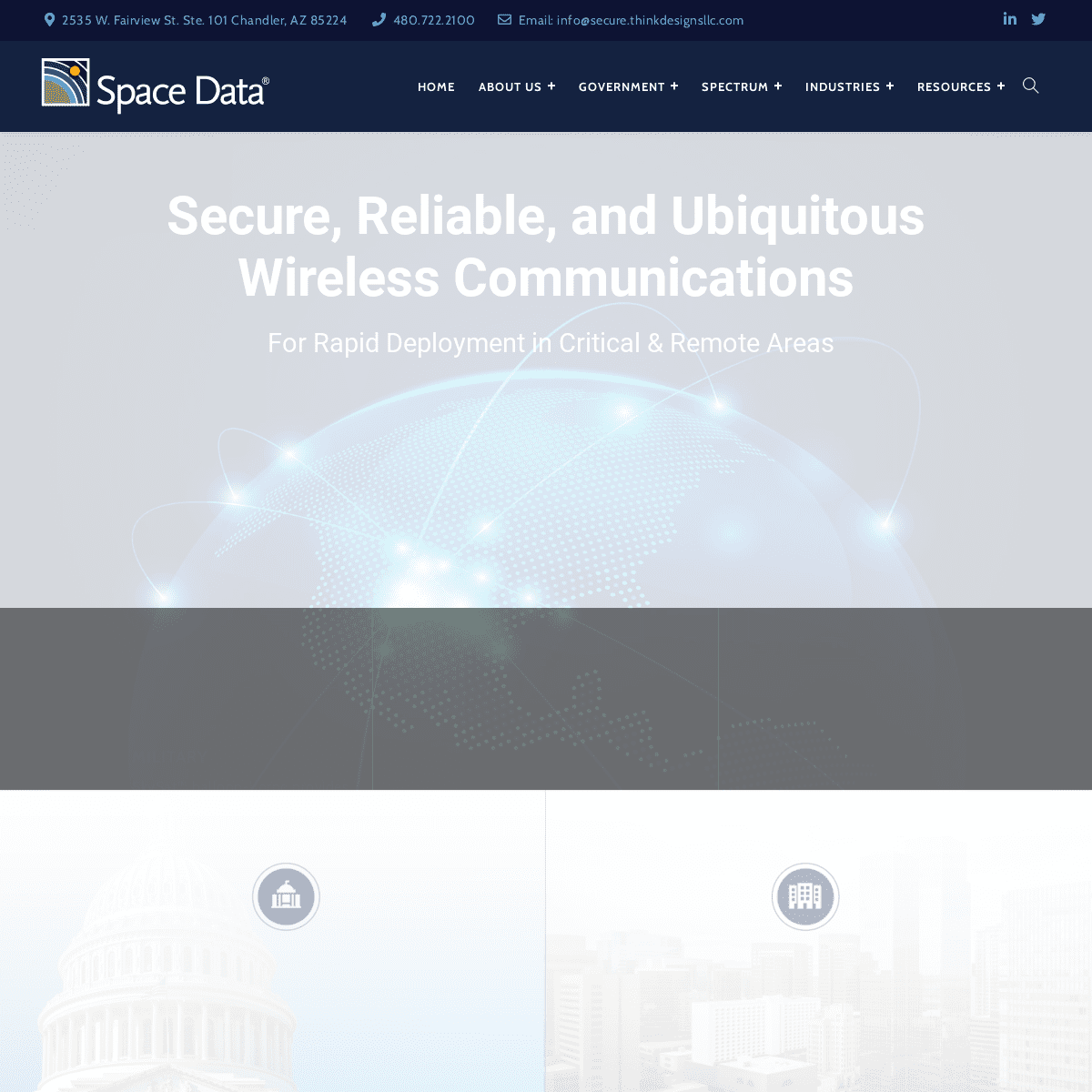
* FCC Licensed Bands & Maps Secure, Reliable, and Ubiquitous Wireless Communications For Rapid Deployment in Critical & Remote Areas__
Military
SkySat™ balloon-borne provides critical combat voice and data communications quickly__
UTILITIES
SkySites® low-cost solution for data communications in remote areasquickly
__
Spectrum
Licensed, flexible-use 900 MHz spectrum available nationwide for saleor lease
GOVERNMENT USE
Space Data’s SkySat™ Platform provides cutting-edge communications technology for coverage quickly in remote areas.LERAN MORE
COMMERCIAL USE
Space Data’s SkySite® offers a cost-effective solution for data, voice and video communications over private, flexible-use 900 MHzspectrum.
LEARN MORE
SPACE DATA
FCC LICENSED 900 MHZ SPECTRUM * __ Secure Flexible-use Spectrum Available Nationwide * __ Scalability to Meet Current and Future Needs * __ 1.8 MHz Total Spectrum * __ Six Contiguous Spectrum Blocks from 100 to 400 kHz * __ Protection from Interference Get Started with Spectrum LEARN MORE ABOUT SPACE DATA SPECTRUM Space Data leases and sells licensed Narrowband Personal Communications Service (NPCS) spectrum in the 900 MHz band for Critical Infrastructure Industries (CII) Subscribe newsletterSingle Line Text
Email Address
reCAPTCHA
Submit
INDUSTRIES WE SERVE
RELIABLE, SECURE, FLEXIBLE WIRELESS COMMUNICATIONS SERVICESUtilities
Wireless communications to support safe, reliable transmission and distribution networks.Learn More
Transportation
Fleet operators use wireless technology to locate and manage themovement of trucks.
Learn More
Oil & Gas
Monitoring, alarming and control of remote O&G equipment is crucial inremote areas.
Learn More
SPACE DATA
SKYSAT™ REPEATER PLATFORM * __ Extends the range of standard issue military two-way radios from 10 miles to nearly 500 miles * __ Uses high-altitude radio repeaters to relay critical combat voice information and data * __ Operates as a military-UHF repeater covering 225-375 MHz * __ Cutting-edge technology is currently supporting a variety of U.S. military missions GET STARTED WITH SKYSAT™SPACE DATA
SKYSITE® PLATFORM
* __ Stratospheric platform for cost-effective communications * __ High-altitude balloon-borne transceivers launch every 8 to 12hours
* __ Launches in 20 minutes and rises to 60000-100000 ft. altitude * __ Communications in remote areas with coverage circle >400 miles GET STARTED WITH SkySite®ABOUT US
Space Data delivers wireless services and solutions for commercial and government users in locations and geographies that are not served or are poorly served by existing wireless technologies and serviceproviders.
OUR SERVICES
* Home
* About Us
* Government
* Spectrum
* Industries
* Resources
* Contact Us
CONTACT INFO
* Address: 2535 W. Fairview St.Ste. 101
Chandler, AZ 85224
* Phone: 480.722.2100 * Email: info@secure.thinkdesignsllc.comKEEP IN TOUCH
keeptouch footerformSingle Line Text
Email Address
Paragraph Text
reCAPTCHA
Submit
� 2020 All Rights Reserved · Space Data Corporation Chandler AZ ·Privacy Policy
__
Details
1