6
More Annotations


5


6
Favourite Annotations


6


2
Text
LA RUTA DE LOS PARQUESTRANSLATE THIS PAGEQUIÉNES SOMOSLOS PARQUESCOMUNIDADESVIAJES SUGERIDOSTOUR OPERADORESNOTICIAS La ruta más espectacular del mundo con 17 Parques Nacionales y más de 60 comunidades. 2800 kilómetros de belleza escénica entre Puerto Montt y Cabo de Hornos. ¡Bienvenidos a LA RUTA DE LOS PARQUES » KAWÉSQAR Stay the night in Punta Arenas. 30 minutes in car from the airport to the center of Punta Arenas. 2. Take Route 9 north until you arrive at Puerto Natales, passing through Villa Tehuelches along the way. After 2.5 hours on the paved road, you’ll be in Puerto Natales, where you’ll find various options for lodging, food, and tourist
excursions.
LA RUTA DE LOS PARQUES » PUMALÍN DOUGLAS TOMPKINS NATIONAL The deep forests of Pumalín reach all the way to the fjords, creating one of the most spectacular coastlines on the planet. Hundreds of waterfalls cascade down from glaciers, falling over steep granite walls, as the Michinmahuida and Chaitén Volcanoes crown the landscape. The park’s most notable feature is the threatened Alerce(Fitzroya
LA RUTA DE LOS PARQUES » HORNOPIREN NATIONAL PARK Los Lagos region. Hornopirén National Park, “snow oven” in Mapudungún, forms part of the regional ecosystem of evergreen temperate rainforests. It is known for its rich biodiversity, high levels of endemic species, and thousands-of-years-old trees. This park is part of the World Biosphere Reserve of Temperate Rainforests of theAustral Andes.
LA RUTA DE LOS PARQUES » BERNARDO O’HIGGINS NATIONAL PARK Magallanes region. Bernardo O’Higgins is Chile’s largest park––and one of the largest in the world. Around a quarter of the park lies in the Aysén region, with the rest in Magallanes. The park’s central feature are its 49 glaciers, part of Chile’s Southern Icefields. They form part of the third-longest expanse ofcontinental ice on
LA RUTA DE LOS PARQUES » LAGUNA SAN RAFAEL NATIONAL PARK Drive Route X-78, which reaches the park 32 miles west of Puerto Tranquilo and offers gorgeous views of forests, rivers, dozens of waterfalls, hanging glaciers, and snowy peaks. Take Route X-78 to Monte San Valentín (12,830 feet above sea level), the highest peak in Patagonia. Cross Laguna San Rafael in boat to see the glacier andobserve
LA RUTA DE LOS PARQUES » TRAPANANDA 1. Go south from Coyhaique. After you pass Villa El Blanco, take a right to continue toward Cerro Castillo along the Carretera Austral. After a short while, you’ll enter Cerro Castillo National Park. Drive slowly; it’s common to see Huemules (South Andean Deer) along the side of the road. LA RUTA DE LOS PARQUES » LOS ALERCES One can’t-miss hike is the Los Alerces trail, which allows you to get an up-close view of ancient Alerce trees and take in the evergreen forest in all its magnitude and splendor. 1.5 hours in car from Caleta Gonzalo to Chaitén. 20 minutes in car from Chaitén to El Amarillo.5.
LA RUTA DE LOS PARQUES » CERRO SOMBRERO To get to Cerro Sombrero, you’ll need to cross the Strait of Magellan at Punta Delgada, which is located 106 miles from Punta Arenas along Route CH-225. The voyage across the strait takes around 20 minutes. You can also cross the Strait of Magellan at Tres Puentes, located around 3 miles from Punta Arenas. The crossing takes around 2hours.
LA RUTA DE LOS PARQUES » PARQUE NACIONAL YENDEGAIA Yendegaia means «Deep Bay» in the Yagan language. This park in Tierra del Fuego, declared a Biosphere Reserve, was formed thanks to the donation of more than 93,900 acres by the Yendegaia Foundation, led by Douglas and Kristine Tompkins, as well as the incorporation of more than 274,287 acres of parklands by the Chilean government. LA RUTA DE LOS PARQUESTRANSLATE THIS PAGEQUIÉNES SOMOSLOS PARQUESCOMUNIDADESVIAJES SUGERIDOSTOUR OPERADORESNOTICIAS La ruta más espectacular del mundo con 17 Parques Nacionales y más de 60 comunidades. 2800 kilómetros de belleza escénica entre Puerto Montt y Cabo de Hornos. ¡Bienvenidos a LA RUTA DE LOS PARQUES » KAWÉSQAR Stay the night in Punta Arenas. 30 minutes in car from the airport to the center of Punta Arenas. 2. Take Route 9 north until you arrive at Puerto Natales, passing through Villa Tehuelches along the way. After 2.5 hours on the paved road, you’ll be in Puerto Natales, where you’ll find various options for lodging, food, and touristexcursions.
LA RUTA DE LOS PARQUES » PUMALÍN DOUGLAS TOMPKINS NATIONAL The deep forests of Pumalín reach all the way to the fjords, creating one of the most spectacular coastlines on the planet. Hundreds of waterfalls cascade down from glaciers, falling over steep granite walls, as the Michinmahuida and Chaitén Volcanoes crown the landscape. The park’s most notable feature is the threatened Alerce(Fitzroya
LA RUTA DE LOS PARQUES » HORNOPIREN NATIONAL PARK Los Lagos region. Hornopirén National Park, “snow oven” in Mapudungún, forms part of the regional ecosystem of evergreen temperate rainforests. It is known for its rich biodiversity, high levels of endemic species, and thousands-of-years-old trees. This park is part of the World Biosphere Reserve of Temperate Rainforests of theAustral Andes.
LA RUTA DE LOS PARQUES » BERNARDO O’HIGGINS NATIONAL PARK Magallanes region. Bernardo O’Higgins is Chile’s largest park––and one of the largest in the world. Around a quarter of the park lies in the Aysén region, with the rest in Magallanes. The park’s central feature are its 49 glaciers, part of Chile’s Southern Icefields. They form part of the third-longest expanse ofcontinental ice on
LA RUTA DE LOS PARQUES » LAGUNA SAN RAFAEL NATIONAL PARK Drive Route X-78, which reaches the park 32 miles west of Puerto Tranquilo and offers gorgeous views of forests, rivers, dozens of waterfalls, hanging glaciers, and snowy peaks. Take Route X-78 to Monte San Valentín (12,830 feet above sea level), the highest peak in Patagonia. Cross Laguna San Rafael in boat to see the glacier andobserve
LA RUTA DE LOS PARQUES » TRAPANANDA 1. Go south from Coyhaique. After you pass Villa El Blanco, take a right to continue toward Cerro Castillo along the Carretera Austral. After a short while, you’ll enter Cerro Castillo National Park. Drive slowly; it’s common to see Huemules (South Andean Deer) along the side of the road. LA RUTA DE LOS PARQUES » LOS ALERCES One can’t-miss hike is the Los Alerces trail, which allows you to get an up-close view of ancient Alerce trees and take in the evergreen forest in all its magnitude and splendor. 1.5 hours in car from Caleta Gonzalo to Chaitén. 20 minutes in car from Chaitén to El Amarillo.5.
LA RUTA DE LOS PARQUES » CERRO SOMBRERO To get to Cerro Sombrero, you’ll need to cross the Strait of Magellan at Punta Delgada, which is located 106 miles from Punta Arenas along Route CH-225. The voyage across the strait takes around 20 minutes. You can also cross the Strait of Magellan at Tres Puentes, located around 3 miles from Punta Arenas. The crossing takes around 2hours.
LA RUTA DE LOS PARQUES » PARQUE NACIONAL YENDEGAIA Yendegaia means «Deep Bay» in the Yagan language. This park in Tierra del Fuego, declared a Biosphere Reserve, was formed thanks to the donation of more than 93,900 acres by the Yendegaia Foundation, led by Douglas and Kristine Tompkins, as well as the incorporation of more than 274,287 acres of parklands by the Chilean government. LA RUTA DE LOS PARQUES La ruta más espectacular del mundo con 17 Parques Nacionales y más de 60 comunidades. 2800 kilómetros de belleza escénica entre Puerto Montt y Cabo de Hornos. ¡Bienvenidos a LA RUTA DE LOS PARQUES » WHO WE ARE The Route of Parks is a vision for the conservation of Chilean Patagonia from Tompkins Conservation Chile. This scenic route runs 1,700 miles between Puerto Montt and Cape Horn, spanning 17 national parks. Protecting 28 million acres, it’s also an economic impulse for more than 60 surrounding communities to benefit from conservation. LA RUTA DE LOS PARQUES » PARKS La ruta más espectacular del mundo con 17 Parques Nacionales y más de 60 comunidades. 2800 kilómetros de belleza escénica entre Puerto Montt y Cabo de Hornos. ¡Bienvenidos a LA RUTA DE LOS PARQUES » PATAGONIA NATIONAL PARK Patagonia National Park is located approximately 196 miles south of Coyhaique along the Carretera Austral. Eleven miles before arriving to Cochrane, you’ll come to the crossing that will take you to the Baker entrance. Turn left to follow this road east for 7 miles, until you arrive at the park offices. LA RUTA DE LOS PARQUES » PARQUE NACIONAL YENDEGAIA Yendegaia means «Deep Bay» in the Yagan language. This park in Tierra del Fuego, declared a Biosphere Reserve, was formed thanks to the donation of more than 93,900 acres by the Yendegaia Foundation, led by Douglas and Kristine Tompkins, as well as the incorporation of more than 274,287 acres of parklands by the Chilean government. LA RUTA DE LOS PARQUES » MELIMOYU NATIONAL PARK Flora. Melimoyu is the nexus point between the southern edge of Chile’s temperate rainforests and the far north of the Patagonian subantarctic forest. Its dense forests mix species from the Valdivian rainforests with temperate resinous forests made up of Ciprés de la Guaitecas (Pilgerodendron) and Tepú. Coigües, Cipreses, and Canelosare
LA RUTA DE LOS PARQUES » KAWÉSQAR NATIONAL PARK Kawésqar National Park is one of the largest parks in the world and the second-largest in Chile. It includes large swaths of the archipelagos in the provinces of Magallanes and Última Esperanza, as well as half of Isla Riesco. Its landscapes are a mosaic of cordilleras, forests, glaciers, fjords, lakes, wetlands, andvalleys––virgin
LA RUTA DE LOS PARQUES » PUERTO GUADALTRANSLATE THIS PAGE Parque Nacional Patagonia. Ubicado al suroeste del Lago General Carrera, a 297 kms. de Coyhaique y a 115 kms. de Chile Chico, Puerto Guadal destaca por la belleza de sus alrededores. Con vistas panorámicas a los cordones montañosos que rodean al lago más grande de Chile, denominado por los Tehuelches como Chelenko, es ademásdestino
LA RUTA DE LOS PARQUES » LANZAN CAMPAÑA PARA …TRANSLATE THIS PAGE Que Chile sea reconocido como un ejemplo mundial de turismo basado en la conservación. Esa es la ambición detrás de la campaña Ruta de los Parques de la Patagonia, lanzada por Tompkins Conservation e Imagen de Chile.El proyecto busca posicionar el recorrido de 2.800 kilómetros ubicados entre Puerto Montt y Cabo de Hornos, con sus 17 Parques Nacionales y más de 60 comunidades aledañas LA RUTA DE LOS PARQUES » ALTO PALENATRANSLATE THIS PAGE La cultura cordillerana se respira a destajo en Palena. Tierra de mates, caballos y gauchos, posee además un rico patrimonio natural, cuyo símbolo es el cristalino y caudaloso río Palena, navegable desde esta localidad hasta su desembocadura al mar en Raúl MarínBalmaceda.
* Inicio
* Quiénes Somos
* Parques
* Comunidades
* Viajes
* Tour Operadores
* Noticias
* FAQ’s
* Planifica
* Videos
*
* EN ▾
* Inicio
* Quiénes Somos
* Parques
* Comunidades
* Viajes
* Tour Operadores
* Noticias
* FAQ’s
* Planifica
* Videos
*
* EN ▾
*
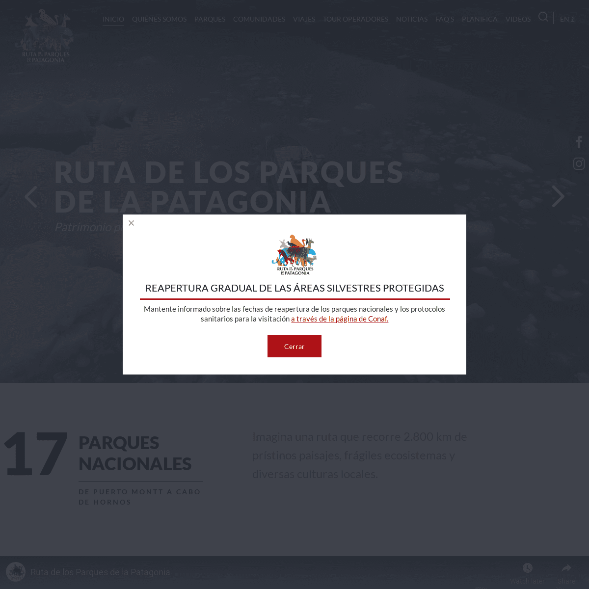
RECORRE
2.800 KM
DESDE PUERTO MONTT A CABO DE HORNOSPLANIFICA TU VIAJE
*
RUTA DE LOS PARQUES DE LA PATAGONIA PATRIMONIO PROTEGIDO DE TODOS LOS CHILENOS*
PROTEGE
11,8 MILLONES
DE HECTÁREAS
*
CONSERVA
17 PARQUES NACIONALES*
DESCUBRE
MÁS DE 60 COMUNIDADES*
RECORRE
2.800 KM
DESDE PUERTO MONTT A CABO DE HORNOSPLANIFICA TU VIAJE
*
RUTA DE LOS PARQUES DE LA PATAGONIA PATRIMONIO PROTEGIDO DE TODOS LOS CHILENOS* Previous
* Next
*
*
17
PARQUES
NACIONALES
De Puerto Montt a Cabo de Hornos Imagina una ruta que recorre 2.800 km de prístinos paisajes, frágiles ecosistemas y diversas culturas locales. Imagina que la ruta escénica más bella del mundo ya existe y estáen Chile.
CONOCE MÁS SOBRE LA RUTA*
RESGUARDA 24 ECOSISTEMAS, REFUGIO DE 140 ESPECIES DE AVES Y 46 DEMAMÍFEROS
PARQUE NACIONAL TORRES DEL PAINE, Región de Magallanes ©Tompkins Conservation Chile*
CONCENTRA MÁS DEL 90% DEL TERRITORIO PROTEGIDO BAJO CATEGORÍAPARQUES NACIONALES
PARQUE NACIONAL KAWÉSQAR, Región de Magallanes ©Antonio Vizcaíno*
PROTEGE 11,8 MILLONES DE HECTÁREAS DE PRÍSTINOS ECOSISTEMAS PARQUE NACIONAL PUMALÍN DOUGLAS TOMPKINS, Región de Los Lagos ©Augusto Dominguez*
CONECTA 17 PARQUES NACIONALES DESDE PUERTO MONTT A CABO DE HORNOS PARQUE NACIONAL PATAGONIA, Región de Aysén ©Tompkins Conservation Chile*
RECORRE 2.800 KM DE RUTAS MARÍTIMAS Y TERRESTRES PARQUE NACIONAL CERRO CASTILLO, Región de Aysén ©Tompkins Conservation Chile*
RESGUARDA 24 ECOSISTEMAS, REFUGIO DE 140 ESPECIES DE AVES Y 46 DEMAMÍFEROS
PARQUE NACIONAL TORRES DEL PAINE, Región de Magallanes ©Tompkins Conservation Chile*
CONCENTRA MÁS DEL 90% DEL TERRITORIO PROTEGIDO BAJO CATEGORÍAPARQUES NACIONALES
PARQUE NACIONAL KAWÉSQAR, Región de Magallanes ©Antonio Vizcaíno* Previous
* Next
RECORRE LOS PARQUES
REGIÓN DE LOS LAGOS PARQUE NACIONAL PUMALÍN DOUGLAS TOMPKINS Ubicado al sur de Puerto Montt, Pumalín conserva Alerces de casi 3 mil años y ofrece más de una decena de senderos para explorar el bosque templado lluvioso.REGIÓN DE AYSÉN
PARQUE NACIONAL PATAGONIA Valles inmensos, moldeados por el río Chacabuco, forman un corredor natural transitado desde tiempos ancestrales por etnias nómades y una gran diversidad de fauna.REGIÓN DE AYSÉN
PARQUE NACIONAL CERRO CASTILLO El magnífico Cerro Castillo se eleva 2.318 metros sobre las comunas de Coyhaique y Río Ibañez, y en su alrededor se despliega un circuito de trekking que ha sido catalogado como uno de los másbellos de Chile.
REGIÓN DE MAGALLANES PARQUE NACIONAL TORRES DEL PAINE Declarado como la Octava Maravilla del Mundo y Reserva de la Biósfera por Unesco, el macizo Paine es conocido como una de las montañas másbellas del planeta.
VER TODOS LOS PARQUES+ 60
COMUNIDADES
La Ruta de los Parques es una nueva manera de interpretar la inmensidad de nuestra Patagonia: una visión de desarrollo económico basada en la conservación y el turismo de naturaleza. POR QUÉ ES IMPORTANTE LA RUTA*
EL 2017 LA LLEGADA DE TURISTAS SE INCREMENTÓ EN UN 14%Palena
*
LA RUTA BENEFICIA A MÁS DE 60 COMUNIDADES LOCALESRegión de Aysén
*
POR CADA DÓLAR INVERTIDO EN PARQUES NACIONALES, ENTRE 6 A 10 RETORNAN A LA ECONOMÍA LOCALIsla Magdalena
*
MÁS DEL 50% DEL TURISTA EXTRANJERO QUE VISITÓ CHILE DURANTE EL 2016, LLEGÓ ATRAÍDO POR EL TURISMO DE NATURALEZARío Baker
*
EN LA ÚLTIMA DÉCADA SE HA TRIPLICADO LA VISITA A LOS PARQUESNACIONALES DE CHILE
Chaitén
*
EL 2017 LA LLEGADA DE TURISTAS SE INCREMENTÓ EN UN 14%Palena
*
LA RUTA BENEFICIA A MÁS DE 60 COMUNIDADES LOCALESRegión de Aysén
* Previous
* Next
VIAJES
SUGERIDOS
5 - 6 DÍAS
GLACIARES Y LAGOS DE AYSÉN Dirígete desde Coyhaique hacia el sur por la Carretera Austral hasta Puerto Tranquilo, puerta de entrada al Parque Nacional Laguna San Rafael, visitando las formaciones de mármol del Lago General Carrera desde Puerto Sánchez. Retorna hacia el norte para explorar el Parque Nacional Cerro Castillo.11- 13 DÍAS
TRAPANANDA
Descubre una de las zonas más prístinas de la Patagonia, visitando el Parque Nacional Cerro Castillo, para luego dirigirte hacia Puerto Tranquilo, puerta de entrada al Parque Nacional Laguna San Rafael. Continúa rumbo sur para explorar las maravillas del Parque Nacional Patagonia, Tortel y Villa O´Higgins.11- 13 DÍAS
ESTEPAS Y CANALES
Cruza el lago más grande de Chile desde Puerto Ibáñez hasta Chile Chico para recorrer Jeinimeni y luego cruzar la frontera hasta el Paso Roballos. Desde ahí retorna a Chile para atravesar el impresionante Valle Chacabuco, y luego continuar hasta Puerto Yungay para navegar por los canales Kawésqar hasta Puerto Natales, puerta de entrada aTorres del Paine.
VER TODAS LAS RUTAS
@RUTADELOSPARQUESDELAPATAGONIA En este Día Mundial del Medio Ambiente el llamado En otoño, los bosques de Nothofagus -lenga, ñire Los parques nacionales salvan hábitats y también Las Ranitas de Darwin y su vulnerabilidad ante la NOTICIAS Y PUBLICACIONES25 MAYO, 2021
PUBLICAN LIBRO DIGITAL SOBRE RESTAURACIÓN DE EL AMARILLO Tompkins Conservation Chile junto a la comunidad de El Amarillo, en la región de Los Lagos, impulsó un proyecto de embellecimiento en esta localidad que es portal de entrada del Parque Pumalín Douglas Tompkins. Nuevo libro digital relata la historia.29 ABRIL, 2021
�RECORRIDO POR LA RUTA DE LOS PARQUES EN LA REGIÓN DE AYSÉN!* Noticias
* Descargas
* Contacto
* Galería de fotos
QUIERO RECIBIR INFORMACIÓN Copyright 2018 Ruta de los Parques de la Patagonia hecho en puerto varas por 2litros REAPERTURA GRADUAL DE LAS ÁREAS SILVESTRES PROTEGIDAS Mantente informado sobre las fechas de reapertura de los parques nacionales y los protocolos sanitarios para la visitación a través de la página de Conaf.Cerrar
Details
1