2
More Annotations


6


3
Favourite Annotations


1


1
Text
HOME - ICPRB - POTOMAC RIVERABOUT ICPRBPOTOMAC BASIN FACTSFOCUS AREASRESOURCESPOTOMAC JURISDICTIONS ICPRB's mission is to protect and enhance the waters and related resources of the Potomac River basin through science, regional cooperation, and education. POTOMAC BASIN COMPREHENSIVE WATER RESOURCES PLAN COOPERATIVE WATER SUPPLY OPERATIONS ON THE POTOMAC Water Supply Management. ICPRB’s Section for Cooperative Water Supply Operations on the Potomac (CO-OP) was established in 1979 to serve as a cooperative technical center RECREATIONAL MAPS OF THE LOWER POTOMAC RIVER These maps span 92 miles of the most popular part of the Potomac river and C&O Canal above Washington, D.C. Each map is conveniently available for downloading and printing in a PDF format. Each one shows a portion of the C&O Canal in the Lower Potomac River area. UPPER POTOMAC MAP SETS Maps of the Upper Potomac River The companion to the Interstate Commission on the Potomac River Basin’s popular “Potomac River and C&O Canal” map set is now available, covering the upper half of the area from Shepherdstown, W.Va., to just upstream of Cumberland, Md. ABOUT THE BASIN: GRAVELLY POINT Gravelly Point Park About the Basin—August 24, 2018. Gravelly Point Park is a favorite spot for kids of all ages for one main reason: the * Facebook
* LinkedIn
* Twitter
* Instagram
* Facebook
* LinkedIn
* Twitter
* Instagram
love of airplanes.
"CHESSIE BIBI" STREAM HEALTH INDICATOR Chessie BIBI. The Chesapeake basin-wide index of biotic integrity for stream macroinvertebrates, or “Chessie BIBI,” is a multi-metric index of stream health applicable to freshwater streams and small rivers across the Chesapeake Bay watershed. JOBS - ICPRB - POTOMAC RIVER Find current employment opportunities at the Interstate Commision on the Potomac River Basin. PHASE 2 EVALUATION OF TRAVILAH QUARRY FOR WATER … PHASE 2 ‐ EVALUATION OF TRAVILAH QUARRY FOR WATER SUPPLY STORAGE Final Report Prepared for: Interstate Commission on the Potomac RiverBasin (ICPRB)
HOME - ICPRB - POTOMAC RIVERABOUT ICPRBPOTOMAC BASIN FACTSFOCUS AREASRESOURCESPOTOMAC JURISDICTIONS ICPRB's mission is to protect and enhance the waters and related resources of the Potomac River basin through science, regional cooperation, and education. POTOMAC BASIN COMPREHENSIVE WATER RESOURCES PLAN COOPERATIVE WATER SUPPLY OPERATIONS ON THE POTOMAC Water Supply Management. ICPRB’s Section for Cooperative Water Supply Operations on the Potomac (CO-OP) was established in 1979 to serve as a cooperative technical center RECREATIONAL MAPS OF THE LOWER POTOMAC RIVER These maps span 92 miles of the most popular part of the Potomac river and C&O Canal above Washington, D.C. Each map is conveniently available for downloading and printing in a PDF format. Each one shows a portion of the C&O Canal in the Lower Potomac River area. UPPER POTOMAC MAP SETS Maps of the Upper Potomac River The companion to the Interstate Commission on the Potomac River Basin’s popular “Potomac River and C&O Canal” map set is now available, covering the upper half of the area from Shepherdstown, W.Va., to just upstream of Cumberland, Md. ABOUT THE BASIN: GRAVELLY POINT Gravelly Point Park About the Basin—August 24, 2018. Gravelly Point Park is a favorite spot for kids of all ages for one main reason: thelove of airplanes.
"CHESSIE BIBI" STREAM HEALTH INDICATOR Chessie BIBI. The Chesapeake basin-wide index of biotic integrity for stream macroinvertebrates, or “Chessie BIBI,” is a multi-metric index of stream health applicable to freshwater streams and small rivers across the Chesapeake Bay watershed. JOBS - ICPRB - POTOMAC RIVER Find current employment opportunities at the Interstate Commision on the Potomac River Basin. PHASE 2 EVALUATION OF TRAVILAH QUARRY FOR WATER … PHASE 2 ‐ EVALUATION OF TRAVILAH QUARRY FOR WATER SUPPLY STORAGE Final Report Prepared for: Interstate Commission on the Potomac RiverBasin (ICPRB)
RECREATIONAL MAPS OF THE LOWER POTOMAC RIVER These maps span 92 miles of the most popular part of the Potomac river and C&O Canal above Washington, D.C. Each map is conveniently available for downloading and printing in a PDF format. Each one shows a portion of the C&O Canal in the Lower Potomac River area. POTOMAC NEWS RESERVOIR, JUNE 10, 2021 Anacostia River, Mattawoman Creek, microplastics, PFAS, and more in the Potomac News Reservoir. POTOMAC BASIN COMPREHENSIVE WATER RESOURCES PLAN One Basin, One Future. The Potomac Basin Comprehensive Water Resources Plan, adopted by the ICPRB Commissioners in June 2018, is the culmination of a multi-year, collaborative process that engaged diverse stakeholders.The plan describes a shared vision for the basin, identifies water resources issues of interstate and/or basin wide significance, and recommends actions for achieving the sharedIS IT SAFE TO SWIM?
Is it safe to swim or boat in the Potomac? Bacterial levels and current may create a safety concern, depending on time of year, weather, and other factors. TREE ID HIKE AT SENECA CREEK STATE PARK 3 p.m. at the Park Office Join the park naturalist in a leisurely walk through the Woodlands area to discover a variety of tree species. They will also discuss trees commonly found in the park to look for on future hikes. A field identification guide is recommended, but notrequired.
WATER SUPPLY OUTLOOK INTERSTATE COMMISSION ON THE POTOMAC 1 Water Supply Outlook June 4, 2021 To subscribe: please email coop@icprb.org Interstate Commission on the Potomac River Basin (ICPRB) 30 W. Gude Drive, Suite 450NEWS ARCHIVE
While a winter snow can lead to warm and cozy day at home, the de-icing materials used to keep traffic flowing can be negatively affecting water quality.MINDFUL BIRDING
Did you know that birding can have a positive impact on your mental health? Take a little time for self-care and join this weekly birding hike, where you and fellow birders will look to the skies and see the beauty of the birds found in Rock Creek Regional Park. A- ICPRB
Spotted Lanternfly Program 12 p.m. at the Tire Playground Learn all about this insect invader coming to our area and the threat it poses to Maryland’s crops! Learn how to identify a spotted lanternfly, what to do if you find one, and pick up some spotted lanternfly-themedgoodies!
WATER WORKS
Water quality is an important factor in the health of humans and animals alike. Participants will test the water quality of Brookside Nature Center’s creek water identifying if it is safe for humans and animals. Participants will also have an opportunity to cool down in Montgomery Parks mobile spray park HOME - ICPRB - POTOMAC RIVERABOUT ICPRBPOTOMAC BASIN FACTSFOCUS AREASRESOURCESPOTOMAC JURISDICTIONS Resources & Maps. ICPRB provides maps, reports, and newsletters to support the public's understanding of the Potomac River and watershed. Calendar of Events. Newsletters, Publications, and Library Resources. Map of the Potomac River Basin. Map of USGS Potomac Watershed StreamGages. Report a
RECREATIONAL MAPS OF THE LOWER POTOMAC RIVER These maps span 92 miles of the most popular part of the Potomac river and C&O Canal above Washington, D.C. Each map is conveniently available for downloading and printing in a PDF format. Each one shows a portion of the C&O Canal in the Lower Potomac River area. POTOMAC BASIN COMPREHENSIVE WATER RESOURCES PLAN COOPERATIVE WATER SUPPLY OPERATIONS ON THE POTOMAC Water Supply Management. ICPRB’s Section for Cooperative Water Supply Operations on the Potomac (CO-OP) was established in 1979 to serve as a cooperative technical center on water resources in the Potomac basin. The Section consists of ICPRB’s District of Columbia, Maryland, Virginia, West Virginia, and Federal Commissioners. UPPER POTOMAC MAP SETS Maps of the Upper Potomac River The companion to the Interstate Commission on the Potomac River Basin’s popular “Potomac River and C&O Canal” map set is now available, covering the upper half of the area from Shepherdstown, W.Va., to just upstream of Cumberland, Md. JOBS - ICPRB - POTOMAC RIVER There are no job postings at this time. Sign up for our newsletter, like us on Facebook, or follow us on Twitter to receive updates on job postings and other news at ICPRB. Contact us for more information. Strategic Plan. Commissioners. Business Meetings. Annual Reports.Staff. Jobs.
CARLINGTON W. WALLACE ARCHIVES A SWAT-based optimization tool for obtaining cost-effective strategies for agricultural conservation practice implementation at watershed scales. The report was published in the November 2019 edition of the Journal of Science of The Total Environment. FILAMENTOUS ALGAE MONITORING PROGRAM: POTOMAC RIVER BASIN Filamentous Algae Monitoring Program: Potomac River Basin . Report to the West Virginia Department of Environmental Protection, Division of Water and Waste Management GROUP OF FRESHWATER MUSSELS FROM SITE #51, GREAT FALLS At upper left is a large Lampilis (complex), the rest are all Eastern Elliptio . Biological Surveys of Three Potomac River Mainstem Reaches . 2014 Summary Report ICPRB # ICP14-8 FISHING AND BOATING SERVICE NORTH BRANCH POTOMAC RIVER Fingerling Trout Stocking –FY17 A total of 104,000 fingerling trout were stocked in the NBPR in FY17. This figure includes 9,000 cutthroat trout, 45,000 brown trout, and 50,000 rainbow trout. Areas stocked were the C&R Areas and the Zero Creel Limit Trout Fishing Area. HOME - ICPRB - POTOMAC RIVERABOUT ICPRBPOTOMAC BASIN FACTSFOCUS AREASRESOURCESPOTOMAC JURISDICTIONS Resources & Maps. ICPRB provides maps, reports, and newsletters to support the public's understanding of the Potomac River and watershed. Calendar of Events. Newsletters, Publications, and Library Resources. Map of the Potomac River Basin. Map of USGS Potomac Watershed StreamGages. Report a
RECREATIONAL MAPS OF THE LOWER POTOMAC RIVER These maps span 92 miles of the most popular part of the Potomac river and C&O Canal above Washington, D.C. Each map is conveniently available for downloading and printing in a PDF format. Each one shows a portion of the C&O Canal in the Lower Potomac River area. POTOMAC BASIN COMPREHENSIVE WATER RESOURCES PLAN COOPERATIVE WATER SUPPLY OPERATIONS ON THE POTOMAC Water Supply Management. ICPRB’s Section for Cooperative Water Supply Operations on the Potomac (CO-OP) was established in 1979 to serve as a cooperative technical center on water resources in the Potomac basin. The Section consists of ICPRB’s District of Columbia, Maryland, Virginia, West Virginia, and Federal Commissioners. UPPER POTOMAC MAP SETS Maps of the Upper Potomac River The companion to the Interstate Commission on the Potomac River Basin’s popular “Potomac River and C&O Canal” map set is now available, covering the upper half of the area from Shepherdstown, W.Va., to just upstream of Cumberland, Md. JOBS - ICPRB - POTOMAC RIVER There are no job postings at this time. Sign up for our newsletter, like us on Facebook, or follow us on Twitter to receive updates on job postings and other news at ICPRB. Contact us for more information. Strategic Plan. Commissioners. Business Meetings. Annual Reports.Staff. Jobs.
CARLINGTON W. WALLACE ARCHIVES A SWAT-based optimization tool for obtaining cost-effective strategies for agricultural conservation practice implementation at watershed scales. The report was published in the November 2019 edition of the Journal of Science of The Total Environment. FILAMENTOUS ALGAE MONITORING PROGRAM: POTOMAC RIVER BASIN Filamentous Algae Monitoring Program: Potomac River Basin . Report to the West Virginia Department of Environmental Protection, Division of Water and Waste Management GROUP OF FRESHWATER MUSSELS FROM SITE #51, GREAT FALLS At upper left is a large Lampilis (complex), the rest are all Eastern Elliptio . Biological Surveys of Three Potomac River Mainstem Reaches . 2014 Summary Report ICPRB # ICP14-8 FISHING AND BOATING SERVICE NORTH BRANCH POTOMAC RIVER Fingerling Trout Stocking –FY17 A total of 104,000 fingerling trout were stocked in the NBPR in FY17. This figure includes 9,000 cutthroat trout, 45,000 brown trout, and 50,000 rainbow trout. Areas stocked were the C&R Areas and the Zero Creel Limit Trout Fishing Area.RESOURCES - ICPRB
Educator Resources. ICPRB staff facilitate workshops and activities to support educators in the Potomac basin. Learn more about current offerings. Score Four: Students, Schools, Streams, and the Bay. Water Ways: Stream Ecology and Monitoring. Watershed Connections Land Use Models. Environmental Resource Directory.IS IT SAFE TO SWIM?
of time, but getting enough of the virus through water is highly unlikely. The primary route of transmission of COVID-19 is through aerosols inhaled. from other people. The short answer is that being out on the water or in the water is a pretty safe. activity, and ismore
POTOMAC BASIN COMPREHENSIVE WATER RESOURCES PLAN One Basin, One Future. The Potomac Basin Comprehensive Water Resources Plan, adopted by the ICPRB Commissioners in June 2018, is the culmination of a multi-year, collaborative process that engaged diverse stakeholders.The plan describes a shared vision for the basin, identifies water resources issues of interstate and/or basin wide significance, and recommends actions for achieving the shared POTOMAC NEWS RESERVOIR, JUNE 10, 2021 1 day ago · Anacostia River, Mattawoman Creek, microplastics, PFAS, and more in the Potomac News Reservoir. PLANTING TREES FROM CONTAINERS OR BALL AND BURLAP Place mulch, soil amendment and trees near the planting site. Dig the hole for the tree – as a rule the width of the hole should be 2-3 times the width of the root ball and the depth should be 1-2 inches less than the height of the root ball. Prune dead branches and crossing or low branches as necessary. Place the dirt from the hole toone side.
NEWS ARCHIVE
While a winter snow can lead to warm and cozy day at home, the de-icing materials used to keep traffic flowing can be negatively affecting water quality. TREE ID HIKE AT SENECA CREEK STATE PARK 1 day ago · 3 p.m. at the Park Office Join the park naturalist in a leisurely walk through the Woodlands area to discover a variety of tree species. They will also discuss trees commonly found in the park to look for on future hikes. A field identification guide is recommended, but not required. WATER SUPPLY OUTLOOK INTERSTATE COMMISSION ON THE POTOMAC 1 Water Supply Outlook June 4, 2021 To subscribe: please email coop@icprb.org Interstate Commission on the Potomac River Basin (ICPRB) 30 W. Gude Drive, Suite 450WATER WORKS
Water quality is an important factor in the health of humans and animals alike. Participants will test the water quality of Brookside Nature Center’s creek water identifying if it is safe for humans and animals. Participants will also have an opportunity to cool down in Montgomery Parks mobile spray parkLAKE TOUR BY KAYAK
Want to watch wildlife or just enjoy a peaceful paddle? Then join us for a leisurely tour of Little Seneca Lake. We could see beaver, herons, maybe even a bald eagle. Basic paddling experience is necessary (this is not a lesson), and you can expect to get a bitdamp.
HOME - ICPRB - POTOMAC RIVERABOUT ICPRBPOTOMAC BASIN FACTSFOCUS AREASRESOURCESPOTOMAC JURISDICTIONS Resources & Maps. ICPRB provides maps, reports, and newsletters to support the public's understanding of the Potomac River and watershed. Calendar of Events. Newsletters, Publications, and Library Resources. Map of the Potomac River Basin. Map of USGS Potomac Watershed StreamGages. Report a
RECREATIONAL MAPS OF THE LOWER POTOMAC RIVER These maps span 92 miles of the most popular part of the Potomac river and C&O Canal above Washington, D.C. Each map is conveniently available for downloading and printing in a PDF format. Each one shows a portion of the C&O Canal in the Lower Potomac River area. POTOMAC BASIN COMPREHENSIVE WATER RESOURCES PLAN COOPERATIVE WATER SUPPLY OPERATIONS ON THE POTOMAC Water Supply Management. ICPRB’s Section for Cooperative Water Supply Operations on the Potomac (CO-OP) was established in 1979 to serve as a cooperative technical center on water resources in the Potomac basin. The Section consists of ICPRB’s District of Columbia, Maryland, Virginia, West Virginia, and Federal Commissioners. UPPER POTOMAC MAP SETS Maps of the Upper Potomac River The companion to the Interstate Commission on the Potomac River Basin’s popular “Potomac River and C&O Canal” map set is now available, covering the upper half of the area from Shepherdstown, W.Va., to just upstream of Cumberland, Md. JOBS - ICPRB - POTOMAC RIVER There are no job postings at this time. Sign up for our newsletter, like us on Facebook, or follow us on Twitter to receive updates on job postings and other news at ICPRB. Contact us for more information. Strategic Plan. Commissioners. Business Meetings. Annual Reports.Staff. Jobs.
CARLINGTON W. WALLACE ARCHIVES A SWAT-based optimization tool for obtaining cost-effective strategies for agricultural conservation practice implementation at watershed scales. The report was published in the November 2019 edition of the Journal of Science of The Total Environment. FILAMENTOUS ALGAE MONITORING PROGRAM: POTOMAC RIVER BASIN Filamentous Algae Monitoring Program: Potomac River Basin . Report to the West Virginia Department of Environmental Protection, Division of Water and Waste Management GROUP OF FRESHWATER MUSSELS FROM SITE #51, GREAT FALLS At upper left is a large Lampilis (complex), the rest are all Eastern Elliptio . Biological Surveys of Three Potomac River Mainstem Reaches . 2014 Summary Report ICPRB # ICP14-8 FISHING AND BOATING SERVICE NORTH BRANCH POTOMAC RIVER Fingerling Trout Stocking –FY17 A total of 104,000 fingerling trout were stocked in the NBPR in FY17. This figure includes 9,000 cutthroat trout, 45,000 brown trout, and 50,000 rainbow trout. Areas stocked were the C&R Areas and the Zero Creel Limit Trout Fishing Area. HOME - ICPRB - POTOMAC RIVERABOUT ICPRBPOTOMAC BASIN FACTSFOCUS AREASRESOURCESPOTOMAC JURISDICTIONS Resources & Maps. ICPRB provides maps, reports, and newsletters to support the public's understanding of the Potomac River and watershed. Calendar of Events. Newsletters, Publications, and Library Resources. Map of the Potomac River Basin. Map of USGS Potomac Watershed StreamGages. Report a
RECREATIONAL MAPS OF THE LOWER POTOMAC RIVER These maps span 92 miles of the most popular part of the Potomac river and C&O Canal above Washington, D.C. Each map is conveniently available for downloading and printing in a PDF format. Each one shows a portion of the C&O Canal in the Lower Potomac River area. POTOMAC BASIN COMPREHENSIVE WATER RESOURCES PLAN COOPERATIVE WATER SUPPLY OPERATIONS ON THE POTOMAC Water Supply Management. ICPRB’s Section for Cooperative Water Supply Operations on the Potomac (CO-OP) was established in 1979 to serve as a cooperative technical center on water resources in the Potomac basin. The Section consists of ICPRB’s District of Columbia, Maryland, Virginia, West Virginia, and Federal Commissioners. UPPER POTOMAC MAP SETS Maps of the Upper Potomac River The companion to the Interstate Commission on the Potomac River Basin’s popular “Potomac River and C&O Canal” map set is now available, covering the upper half of the area from Shepherdstown, W.Va., to just upstream of Cumberland, Md. JOBS - ICPRB - POTOMAC RIVER There are no job postings at this time. Sign up for our newsletter, like us on Facebook, or follow us on Twitter to receive updates on job postings and other news at ICPRB. Contact us for more information. Strategic Plan. Commissioners. Business Meetings. Annual Reports.Staff. Jobs.
CARLINGTON W. WALLACE ARCHIVES A SWAT-based optimization tool for obtaining cost-effective strategies for agricultural conservation practice implementation at watershed scales. The report was published in the November 2019 edition of the Journal of Science of The Total Environment. FILAMENTOUS ALGAE MONITORING PROGRAM: POTOMAC RIVER BASIN Filamentous Algae Monitoring Program: Potomac River Basin . Report to the West Virginia Department of Environmental Protection, Division of Water and Waste Management GROUP OF FRESHWATER MUSSELS FROM SITE #51, GREAT FALLS At upper left is a large Lampilis (complex), the rest are all Eastern Elliptio . Biological Surveys of Three Potomac River Mainstem Reaches . 2014 Summary Report ICPRB # ICP14-8 FISHING AND BOATING SERVICE NORTH BRANCH POTOMAC RIVER Fingerling Trout Stocking –FY17 A total of 104,000 fingerling trout were stocked in the NBPR in FY17. This figure includes 9,000 cutthroat trout, 45,000 brown trout, and 50,000 rainbow trout. Areas stocked were the C&R Areas and the Zero Creel Limit Trout Fishing Area.POTOMAC BASIN FACTS
Map of the Potomac Basin. Based on information from the NLCD 2011 database, the majority of the basin’s land area is covered by forests at 54.6 percent of the land area. Developed land makes up 14.1 percent of the basin’s land area, while agriculture covers 26.0 percent. Water and wetlands make up 5.9 percent of the basin’s landarea.
IS IT SAFE TO SWIM?
of time, but getting enough of the virus through water is highly unlikely. The primary route of transmission of COVID-19 is through aerosols inhaled. from other people. The short answer is that being out on the water or in the water is a pretty safe. activity, and ismore
POTOMAC BASIN COMPREHENSIVE WATER RESOURCES PLAN One Basin, One Future. The Potomac Basin Comprehensive Water Resources Plan, adopted by the ICPRB Commissioners in June 2018, is the culmination of a multi-year, collaborative process that engaged diverse stakeholders.The plan describes a shared vision for the basin, identifies water resources issues of interstate and/or basin wide significance, and recommends actions for achieving the shared POTOMAC NEWS RESERVOIR, JUNE 10, 2021 1 day ago · Anacostia River, Mattawoman Creek, microplastics, PFAS, and more in the Potomac News Reservoir. UPPER POTOMAC MAP SETS Maps of the Upper Potomac River The companion to the Interstate Commission on the Potomac River Basin’s popular “Potomac River and C&O Canal” map set is now available, covering the upper half of the area from Shepherdstown, W.Va., to just upstream of Cumberland, Md. BLOCKHOUSE POINT PARK Blockhouse Point Park is a little-known park that played a large part in history. The park is just north of Great Falls in the western part of Montgomery County on the Maryland side of the Potomac River. To keep an eye on the Confederate troops across the river, Union soldiers used it as a camp and lookout. From high vistas, the C&O Canal andWATER WORKS
Water quality is an important factor in the health of humans and animals alike. Participants will test the water quality of Brookside Nature Center’s creek water identifying if it is safe for humans and animals. Participants will also have an opportunity to cool down in Montgomery Parks mobile spray park TREE ID HIKE AT SENECA CREEK STATE PARK 1 day ago · 3 p.m. at the Park Office Join the park naturalist in a leisurely walk through the Woodlands area to discover a variety of tree species. They will also discuss trees commonly found in the park to look for on future hikes. A field identification guide is recommended, but not required.LAKE TOUR BY KAYAK
Want to watch wildlife or just enjoy a peaceful paddle? Then join us for a leisurely tour of Little Seneca Lake. We could see beaver, herons, maybe even a bald eagle. Basic paddling experience is necessary (this is not a lesson), and you can expect to get a bitdamp.
WATER SUPPLY OUTLOOK INTERSTATE COMMISSION ON THE POTOMAC 1 Water Supply Outlook June 4, 2021 To subscribe: please email coop@icprb.org Interstate Commission on the Potomac River Basin (ICPRB) 30 W. Gude Drive, Suite 450 HOME - ICPRB - POTOMAC RIVERABOUT ICPRBPOTOMAC BASIN FACTSFOCUS AREASRESOURCESPOTOMAC JURISDICTIONS Resources & Maps. ICPRB provides maps, reports, and newsletters to support the public's understanding of the Potomac River and watershed. Calendar of Events. Newsletters, Publications, and Library Resources. Map of the Potomac River Basin. Map of USGS Potomac Watershed StreamGages. Report a
RECREATIONAL MAPS OF THE LOWER POTOMAC RIVER These maps span 92 miles of the most popular part of the Potomac river and C&O Canal above Washington, D.C. Each map is conveniently available for downloading and printing in a PDF format. Each one shows a portion of the C&O Canal in the Lower Potomac River area. POTOMAC BASIN COMPREHENSIVE WATER RESOURCES PLAN COOPERATIVE WATER SUPPLY OPERATIONS ON THE POTOMAC Water Supply Management. ICPRB’s Section for Cooperative Water Supply Operations on the Potomac (CO-OP) was established in 1979 to serve as a cooperative technical center on water resources in the Potomac basin. The Section consists of ICPRB’s District of Columbia, Maryland, Virginia, West Virginia, and Federal Commissioners. UPPER POTOMAC MAP SETS Maps of the Upper Potomac River The companion to the Interstate Commission on the Potomac River Basin’s popular “Potomac River and C&O Canal” map set is now available, covering the upper half of the area from Shepherdstown, W.Va., to just upstream of Cumberland, Md. JOBS - ICPRB - POTOMAC RIVER There are no job postings at this time. Sign up for our newsletter, like us on Facebook, or follow us on Twitter to receive updates on job postings and other news at ICPRB. Contact us for more information. Strategic Plan. Commissioners. Business Meetings. Annual Reports.Staff. Jobs.
"CHESSIE BIBI" STREAM HEALTH INDICATOR Chessie BIBI. The Chesapeake basin-wide index of biotic integrity for stream macroinvertebrates, or “Chessie BIBI,” is a multi-metric index of stream health applicable to freshwater streams and small rivers across the Chesapeake Bay watershed. It is composed of family-level macroinvertebrate metrics (indicators) that areespecially
FILAMENTOUS ALGAE MONITORING PROGRAM: POTOMAC RIVER BASIN Filamentous Algae Monitoring Program: Potomac River Basin . Report to the West Virginia Department of Environmental Protection, Division of Water and Waste Management GROUP OF FRESHWATER MUSSELS FROM SITE #51, GREAT FALLS At upper left is a large Lampilis (complex), the rest are all Eastern Elliptio . Biological Surveys of Three Potomac River Mainstem Reaches . 2014 Summary Report ICPRB # ICP14-8 FISHING AND BOATING SERVICE NORTH BRANCH POTOMAC RIVER Fingerling Trout Stocking –FY17 A total of 104,000 fingerling trout were stocked in the NBPR in FY17. This figure includes 9,000 cutthroat trout, 45,000 brown trout, and 50,000 rainbow trout. Areas stocked were the C&R Areas and the Zero Creel Limit Trout Fishing Area. HOME - ICPRB - POTOMAC RIVERABOUT ICPRBPOTOMAC BASIN FACTSFOCUS AREASRESOURCESPOTOMAC JURISDICTIONS Resources & Maps. ICPRB provides maps, reports, and newsletters to support the public's understanding of the Potomac River and watershed. Calendar of Events. Newsletters, Publications, and Library Resources. Map of the Potomac River Basin. Map of USGS Potomac Watershed StreamGages. Report a
RECREATIONAL MAPS OF THE LOWER POTOMAC RIVER These maps span 92 miles of the most popular part of the Potomac river and C&O Canal above Washington, D.C. Each map is conveniently available for downloading and printing in a PDF format. Each one shows a portion of the C&O Canal in the Lower Potomac River area. POTOMAC BASIN COMPREHENSIVE WATER RESOURCES PLAN COOPERATIVE WATER SUPPLY OPERATIONS ON THE POTOMAC Water Supply Management. ICPRB’s Section for Cooperative Water Supply Operations on the Potomac (CO-OP) was established in 1979 to serve as a cooperative technical center on water resources in the Potomac basin. The Section consists of ICPRB’s District of Columbia, Maryland, Virginia, West Virginia, and Federal Commissioners. UPPER POTOMAC MAP SETS Maps of the Upper Potomac River The companion to the Interstate Commission on the Potomac River Basin’s popular “Potomac River and C&O Canal” map set is now available, covering the upper half of the area from Shepherdstown, W.Va., to just upstream of Cumberland, Md. JOBS - ICPRB - POTOMAC RIVER There are no job postings at this time. Sign up for our newsletter, like us on Facebook, or follow us on Twitter to receive updates on job postings and other news at ICPRB. Contact us for more information. Strategic Plan. Commissioners. Business Meetings. Annual Reports.Staff. Jobs.
"CHESSIE BIBI" STREAM HEALTH INDICATOR Chessie BIBI. The Chesapeake basin-wide index of biotic integrity for stream macroinvertebrates, or “Chessie BIBI,” is a multi-metric index of stream health applicable to freshwater streams and small rivers across the Chesapeake Bay watershed. It is composed of family-level macroinvertebrate metrics (indicators) that areespecially
FILAMENTOUS ALGAE MONITORING PROGRAM: POTOMAC RIVER BASIN Filamentous Algae Monitoring Program: Potomac River Basin . Report to the West Virginia Department of Environmental Protection, Division of Water and Waste Management GROUP OF FRESHWATER MUSSELS FROM SITE #51, GREAT FALLS At upper left is a large Lampilis (complex), the rest are all Eastern Elliptio . Biological Surveys of Three Potomac River Mainstem Reaches . 2014 Summary Report ICPRB # ICP14-8 FISHING AND BOATING SERVICE NORTH BRANCH POTOMAC RIVER Fingerling Trout Stocking –FY17 A total of 104,000 fingerling trout were stocked in the NBPR in FY17. This figure includes 9,000 cutthroat trout, 45,000 brown trout, and 50,000 rainbow trout. Areas stocked were the C&R Areas and the Zero Creel Limit Trout Fishing Area.POTOMAC BASIN FACTS
Map of the Potomac Basin. Based on information from the NLCD 2011 database, the majority of the basin’s land area is covered by forests at 54.6 percent of the land area. Developed land makes up 14.1 percent of the basin’s land area, while agriculture covers 26.0 percent. Water and wetlands make up 5.9 percent of the basin’s landarea.
POTOMAC BASIN COMPREHENSIVE WATER RESOURCES PLAN One Basin, One Future. The Potomac Basin Comprehensive Water Resources Plan, adopted by the ICPRB Commissioners in June 2018, is the culmination of a multi-year, collaborative process that engaged diverse stakeholders.The plan describes a shared vision for the basin, identifies water resources issues of interstate and/or basin wide significance, and recommends actions for achieving the sharedIS IT SAFE TO SWIM?
of time, but getting enough of the virus through water is highly unlikely. The primary route of transmission of COVID-19 is through aerosols inhaled. from other people. The short answer is that being out on the water or in the water is a pretty safe. activity, and ismore
WATER SUPPLY OUTLOOK INTERSTATE COMMISSION ON THE POTOMAC 1 Water Supply Outlook June 4, 2021 To subscribe: please email coop@icprb.org Interstate Commission on the Potomac River Basin (ICPRB) 30 W. Gude Drive, Suite 450 UPPER POTOMAC MAP SETS Maps of the Upper Potomac River The companion to the Interstate Commission on the Potomac River Basin’s popular “Potomac River and C&O Canal” map set is now available, covering the upper half of the area from Shepherdstown, W.Va., to just upstream of Cumberland, Md.WATER WORKS
Water quality is an important factor in the health of humans and animals alike. Participants will test the water quality of Brookside Nature Center’s creek water identifying if it is safe for humans and animals. Participants will also have an opportunity to cool down in Montgomery Parks mobile spray parkLAKE TOUR BY KAYAK
Want to watch wildlife or just enjoy a peaceful paddle? Then join us for a leisurely tour of Little Seneca Lake. We could see beaver, herons, maybe even a bald eagle. Basic paddling experience is necessary (this is not a lesson), and you can expect to get a bitdamp.
BLOCKHOUSE POINT PARK Blockhouse Point Park is a little-known park that played a large part in history. The park is just north of Great Falls in the western part of Montgomery County on the Maryland side of the Potomac River. To keep an eye on the Confederate troops across the river, Union soldiers used it as a camp and lookout. From high vistas, the C&O Canal andMINDFUL BIRDING
Did you know that birding can have a positive impact on your mental health? Take a little time for self-care and join this weekly birding hike, where you and fellow birders will look to the skies and see the beauty of the birds found in Rock Creek Regional Park. A POTOMAC BASIN BASICS Potomac Basin Basics THE BASIN: Drainage area includes 14,670 square miles in the District of Columbia, Maryland, Pennsylvania, Virginia, and West Virginia. MAINSTEM HOME - ICPRB - POTOMAC RIVERABOUT ICPRBPOTOMAC BASIN FACTSFOCUS AREASRESOURCESPOTOMAC JURISDICTIONS Resources & Maps. ICPRB provides maps, reports, and newsletters to support the public's understanding of the Potomac River and watershed. Calendar of Events. Newsletters, Publications, and Library Resources. Map of the Potomac River Basin. Map of USGS Potomac Watershed StreamGages. Report a
POTOMAC BASIN COMPREHENSIVE WATER RESOURCES PLAN UPPER POTOMAC MAP SETS Maps of the Upper Potomac River The companion to the Interstate Commission on the Potomac River Basin’s popular “Potomac River and C&O Canal” map set is now available, covering the upper half of the area from Shepherdstown, W.Va., to just upstream of Cumberland, Md. COOPERATIVE WATER SUPPLY OPERATIONS ON THE POTOMAC Water Supply Management. ICPRB’s Section for Cooperative Water Supply Operations on the Potomac (CO-OP) was established in 1979 to serve as a cooperative technical center on water resources in the Potomac basin. The Section consists of ICPRB’s District of Columbia, Maryland, Virginia, West Virginia, and Federal Commissioners. JOBS - ICPRB - POTOMAC RIVER There are no job postings at this time. Sign up for our newsletter, like us on Facebook, or follow us on Twitter to receive updates on job postings and other news at ICPRB. Contact us for more information. Strategic Plan. Commissioners. Business Meetings. Annual Reports.Staff. Jobs.
"CHESSIE BIBI" STREAM HEALTH INDICATOR Chessie BIBI. The Chesapeake basin-wide index of biotic integrity for stream macroinvertebrates, or “Chessie BIBI,” is a multi-metric index of stream health applicable to freshwater streams and small rivers across the Chesapeake Bay watershed. It is composed of family-level macroinvertebrate metrics (indicators) that areespecially
POTOMAC BASIN UNREPORTED WATER USE Pta ain nrerte Water e 4 Overall, self-supplied domestic water use represents almost half (47.6%) of the unreported water uses in the basin, followed by agricultural irrigation and livestock uses (23.3% and 28.5%, respectively) (Figure 3). FILAMENTOUS ALGAE MONITORING PROGRAM: POTOMAC RIVER BASIN Filamentous Algae Monitoring Program: Potomac River Basin . Report to the West Virginia Department of Environmental Protection, Division of Water and Waste Management METHODS FOR ESTIMATING FILAMENTOUS ALGAE COVER Methods for Estimating Filamentous Algae Cover in Streams and Rivers of the Shenandoah River Basin Final Report May 20, 2015 Adam N. Griggs Gordon Michael Selckmann FISHING AND BOATING SERVICE NORTH BRANCH POTOMAC RIVER Fingerling Trout Stocking –FY17 A total of 104,000 fingerling trout were stocked in the NBPR in FY17. This figure includes 9,000 cutthroat trout, 45,000 brown trout, and 50,000 rainbow trout. Areas stocked were the C&R Areas and the Zero Creel Limit Trout Fishing Area. HOME - ICPRB - POTOMAC RIVERABOUT ICPRBPOTOMAC BASIN FACTSFOCUS AREASRESOURCESPOTOMAC JURISDICTIONS Resources & Maps. ICPRB provides maps, reports, and newsletters to support the public's understanding of the Potomac River and watershed. Calendar of Events. Newsletters, Publications, and Library Resources. Map of the Potomac River Basin. Map of USGS Potomac Watershed StreamGages. Report a
POTOMAC BASIN COMPREHENSIVE WATER RESOURCES PLAN UPPER POTOMAC MAP SETS Maps of the Upper Potomac River The companion to the Interstate Commission on the Potomac River Basin’s popular “Potomac River and C&O Canal” map set is now available, covering the upper half of the area from Shepherdstown, W.Va., to just upstream of Cumberland, Md. COOPERATIVE WATER SUPPLY OPERATIONS ON THE POTOMAC Water Supply Management. ICPRB’s Section for Cooperative Water Supply Operations on the Potomac (CO-OP) was established in 1979 to serve as a cooperative technical center on water resources in the Potomac basin. The Section consists of ICPRB’s District of Columbia, Maryland, Virginia, West Virginia, and Federal Commissioners. JOBS - ICPRB - POTOMAC RIVER There are no job postings at this time. Sign up for our newsletter, like us on Facebook, or follow us on Twitter to receive updates on job postings and other news at ICPRB. Contact us for more information. Strategic Plan. Commissioners. Business Meetings. Annual Reports.Staff. Jobs.
"CHESSIE BIBI" STREAM HEALTH INDICATOR Chessie BIBI. The Chesapeake basin-wide index of biotic integrity for stream macroinvertebrates, or “Chessie BIBI,” is a multi-metric index of stream health applicable to freshwater streams and small rivers across the Chesapeake Bay watershed. It is composed of family-level macroinvertebrate metrics (indicators) that areespecially
POTOMAC BASIN UNREPORTED WATER USE Pta ain nrerte Water e 4 Overall, self-supplied domestic water use represents almost half (47.6%) of the unreported water uses in the basin, followed by agricultural irrigation and livestock uses (23.3% and 28.5%, respectively) (Figure 3). FILAMENTOUS ALGAE MONITORING PROGRAM: POTOMAC RIVER BASIN Filamentous Algae Monitoring Program: Potomac River Basin . Report to the West Virginia Department of Environmental Protection, Division of Water and Waste Management METHODS FOR ESTIMATING FILAMENTOUS ALGAE COVER Methods for Estimating Filamentous Algae Cover in Streams and Rivers of the Shenandoah River Basin Final Report May 20, 2015 Adam N. Griggs Gordon Michael Selckmann FISHING AND BOATING SERVICE NORTH BRANCH POTOMAC RIVER Fingerling Trout Stocking –FY17 A total of 104,000 fingerling trout were stocked in the NBPR in FY17. This figure includes 9,000 cutthroat trout, 45,000 brown trout, and 50,000 rainbow trout. Areas stocked were the C&R Areas and the Zero Creel Limit Trout Fishing Area. WATER SUPPLY OUTLOOK INTERSTATE COMMISSION ON THE POTOMAC 1 Water Supply Outlook June 4, 2021 To subscribe: please email coop@icprb.org Interstate Commission on the Potomac River Basin (ICPRB) 30 W. Gude Drive, Suite 450IS IT SAFE TO SWIM?
of time, but getting enough of the virus through water is highly unlikely. The primary route of transmission of COVID-19 is through aerosols inhaled. from other people. The short answer is that being out on the water or in the water is a pretty safe. activity, and ismore
RECREATIONAL MAPS OF THE LOWER POTOMAC RIVER These maps span 92 miles of the most popular part of the Potomac river and C&O Canal above Washington, D.C. Each map is conveniently available for downloading and printing in a PDF format. Each one shows a portion of the C&O Canal in the Lower Potomac River area. ABOUT THE BASIN: GRAVELLY POINT Gravelly Point is located alongside the 18-mile Mount Vernon Trail, which runs from Theodore Roosevelt Island to George Washington’s Mount Vernon Estate. This trail is a favorite of bicyclists, runners, and walkers for its smooth surface and beautiful views. The rocky shoreline is a prime spot for anglers. Kayaking on the Potomac River. STAFF - ICPRB - POTOMAC RIVER For general information, contact 301-984-1908 or email us. For more information about staff expertise, visit the ICPRB Staff Education and Project Expertise page. ADMINISTRATION. Mike Nardolilli. Executive Director. Robert Bolle. General Counsel. Harold Hodges. Director,Administration.
CO-OP HISTORY
Coordinated Operation. Negotiations in the mid 1970s among the utilities, Maryland, and Virginia, took several years as the Corps of Engineers sought a drought allocation scheme that would protect the District of Columbia’s access to water and provide for the growing suburbs in Maryland and Virginia. The 1978 Potomac River Low FlowAllocation
DROUGHT MONITORING AND OPERATIONS ON THE POTOMAC RIVER CO-OP begins drought operations when flow in the Potomac River at the U.S. Geological Survey gage at Little Falls dam drops below the total metropolitan area supplier daily withdrawals plus the 100 million gallons per day flow-by, or when CO-OP flow forecasts indicate that there is a significant chance that releases from Jennings Randolph and/or Little Seneca reservoirs will be needed within STENCILING STORM DRAINS Here is a comparison between the costs associated with stenciling 100 storm drains and the costs associated with placing pre-made markers: Pre-made Markers. Stencil. Pre-made markers – $150-$450 (depending on size, quality, and if a custom message is added) Wire brushes (3) – $9.00. Door hangers – $25.00. Glue – $50.00. 2020 WASHINGTON METROPOLITAN AREA WATER SUPPLY STUDY WMA Demand and Resource Availability Forecast for 2050 ICPRB CO-OP, Sep 2020 vi Table 3-25: Forecast of average annual water production, by supplier customers, 2020-2050 (MGD). 3-41 FAQ ON THE UPPER POTOMAC SPILL FAQ on the Upper Potomac Spill. September 30, 2015 ICPRB News. Below are some of the most frequently asked questions ICPRB has received regarding the September 23, 2015, spill in Luke, Md. If you have additional questions, please feel free to contact us. We will continue to update this page as more information is available. INTERSTATE COMMISSION ON THE POTOMAC RIVER BASINMenu
NAVIGATION
* About ICPRB
* Strategic Plan
* Commissioners
* Annual Reports
* Staff
* Jobs
* Directions
* Sitemap
* Potomac Basin Facts * Potomac Jurisdictions* Potomac Timeline
* Focus Areas
* Drinking Water and Water Resources* Water Quality
* Aquatic Life
* Communication & Education * ICPRB and the Chesapeake Bay* Resources
* Maps
* Publications
* Educator Resources* Get Involved
* Home
* Contact Us
* Sitemap
< >
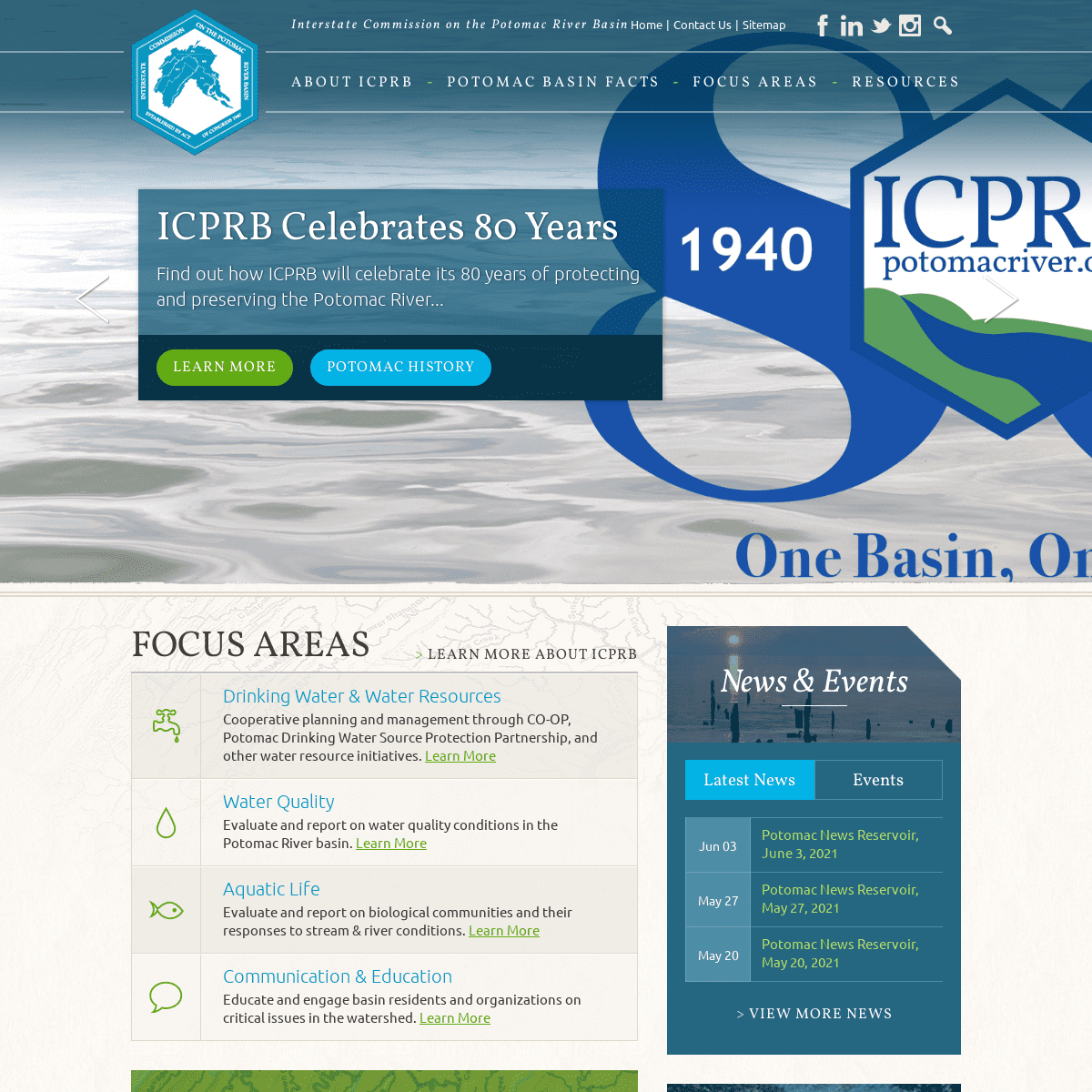
ICPRB CELEBRATES 80 YEARS Find out how ICPRB will celebrate its 80 years of protecting and preserving the Potomac River...Learn More Potomac
History
ICPRB CELEBRATES 80 YEARS Find out how ICPRB will celebrate its 80 years of protecting and preserving the Potomac River...Learn More Potomac
History
REPORTING A SPILL?
Suspected pollution incidents should be quickly reported to the authorities. ICPRB provides contact details for who to call and what information you need to report a spill.Report a Spill
Emergency River Spill Model BASIN-WIDE COMPREHENSIVE PLAN Working towards a roadmap to achieving our shared vision that the Potomac River Basin will serve as a national model for water resources management that fulfills human and ecological needs for current andfuture generations.
Learn More
Advisory Committee
SECTION FOR COOPERATIVE WATER SUPPLY OPERATIONS ON THE POTOMAC ICPRB’s CO-OP Section is the leader for cooperative water supply management for the metro Washington, D.C., area.Learn More
Most Recent Water Supply Outlook< >
FOCUS AREAS
Learn More About ICPRB DRINKING WATER & WATER RESOURCES Cooperative planning and management through CO-OP, Potomac Drinking Water Source Protection Partnership, and other water resource initiatives. Learn MoreWATER QUALITY
Evaluate and report on water quality conditions in the Potomac Riverbasin. Learn More
AQUATIC LIFE
Evaluate and report on biological communities and their responses to stream & river conditions. Learn More COMMUNICATION & EDUCATION Educate and engage basin residents and organizations on critical issues in the watershed. Learn MoreRESOURCES & MAPS
ICPRB provides maps, reports, and newsletters to support the public's understanding of the Potomac River and watershed. * Calendar of Events * Newsletters, Publications, and Library Resources * Map of the Potomac River Basin* Report a Spill
Explore All ICPRB ResourcesNEWS & EVENTS
* Latest News
* Upcoming Events
Jun 03
POTOMAC NEWS RESERVOIR, JUNE 3, 2021May 27
POTOMAC NEWS RESERVOIR, MAY 27, 2021May 20
POTOMAC NEWS RESERVOIR, MAY 20, 2021View More News
View More Events
BASIN-WIDE COMPREHENSIVE PLAN A National Model for Water Resources Management Over 6 million people and diverse ecosystems depend on the interstate water resources of the Potomac river basin. Responsible management of this resource will require collaborative planning that bridges political boundaries. An adaptive basin-wide comprehensive water resources plan serves as a roadmap for the sustainable use of this interstate resource now and into the future. ICPRB has teamed up with state, federal, and local agencies, and private citizens to work towards a plan that will serve as a national model for water resources management. Learn more…Read More
SIGN UP FOR OUR MAILING LISTABOUT US
* About ICPRB
* Strategic Plan
* Commissioners
* Business Meetings
* Annual Reports
* Staff
* Jobs
* Contact Us
* Sitemap
POTOMAC BASIN FACTS
* Potomac Timeline
* Potomac JurisdictionsFOCUS AREAS
* Drinking Water and Water Resources* Water Quality
* Aquatic Life
* Communication & EducationRESOURCES
* Maps
* Publications
* Educator Resources* Get Involved
* News
* Report a Spill
ICPRB, 30 West Gude Drive, Suite 450, Rockville, MD 20850301.984.1908
Copyright © ICPRB 2021 / Privacy Policy/ Website Design
by Wood Street, Inc.Details
1