4
More Annotations


2


2
Favourite Annotations


4


6
Text
EMLID – RTK GNSS/GPS RECEIVERS WITH CENTIMETER ACCURACYREACH RS2REACH RSREACH M2/MCONTACTSBLOGCOMMUNITY Emlid produces affordable GNSS modules and receivers suitable for RTK and PPK. Highly accurate Reach receivers can work with signals from all the main satellite systems: GPS, GLONASS. They also accept data from BeiDou, QZSS, Galileo. Emlid RTK receivers and modules obtain corrections over LoRa radio, Bluetooth, or NTRIP.
REACH M2 AND M+
Reach solves the problem of positioning by connecting directly to the camera hot shoe port, which is synced with the shutter. The time and coordinates of each photo are logged with a resolution of less than a microsecond. This method allows GCPs to be used only to check your accuracy. 1. Connect Reach to a hot shoe port on a camera. REACH FIRMWARE 26 UPDATE: LEGACY RTCM3 MESSAGES AND NMEA Access to Reach Panel from ReachView 3. In the Reach Panel, open the Position Output tab, select the NMEA format, and then set up a Talker ID, the required messages, and their frequency. Keep in mind that the NMEA output rate should be equal to or lower than the RTK Settings rate. NMEA output configuration in Reach Panel. REACH RS2 – MULTI-BAND RTK GNSS RECEIVER FOR NAVIGATION Reach RS2 gets a fixed solution in just seconds and maintains robust performance even in challenging conditions. Centimeter accuracy can be achieved on distances up to 60 km in RTK, and 100 km in PPK mode. GPS, GLONASS, BeiDou, Galileo, and QZSS. L1OF, L2OF, L1C/A, L2C, GETTING STARTED WITH REACHVIEW 3 Get ReachView 3 Today. ReachView 3 is an entirely new mobile app by Emlid. Familiar point collection and stakeout tools are now powered with the completely new user interface, coordinate system support, and ability to manage big projects. GETTING STARTED WITH REACH RS2 Connect to RS2 like to a usual Wi-Fi network. By default login and password are these: Login. reach:xx:xx. Password. emlidreach. Then open ReachView app. Search for ReachView in App Store or Google Play, or scan the QR code on the sticker on top of Reach. In ReachView you'll see a list of Reach receivers in the same Wi-Fi network as yourdevice
HOW TO PLACE GROUND CONTROL POINTS: TUTORIAL BY EMLID by Kseniia Volodina. Ground Control Points are vital when it comes to accurate drone mapping and surveying. GCPs are known points placed on the survey site to act as reference points in post-processing. When “stitching” the drone pictures together, GCPs are the markers that help you make the final model more accurate.EMLID NTRIP CASTER
Emlid NTRIP Caster. Pass corrections between your RTK GNSS receivers over the Internet. Emlid Caster is an easy way to pass RTK corrections between your receivers through the Internet. Our caster works with Reach and any other receivers with NTRIP support. STAKE OUT POINTS WITH REACHVIEW V2.16 Stake out Points with ReachView v2.16. ReachView v2.16 introduces one of the most awaited surveying features–point stakeout. Any point you have in your project now has the stakeout button active. Import geo data in CSV, GeoJSON, DXF! Reach M+ now officially supports LoRa radio. Plug the LoRa module to your M+ and get corrections from RS+.INTRODUCTION
Introduction. This is a documentation for Navio2 - autopilot HAT for Raspberry Pi. Documentation for Navio+ can be found here. EMLID – RTK GNSS/GPS RECEIVERS WITH CENTIMETER ACCURACYREACH RS2REACH RSREACH M2/MCONTACTSBLOGCOMMUNITY Emlid produces affordable GNSS modules and receivers suitable for RTK and PPK. Highly accurate Reach receivers can work with signals from all the main satellite systems: GPS, GLONASS. They also accept data from BeiDou, QZSS, Galileo. Emlid RTK receivers and modules obtain corrections over LoRa radio, Bluetooth, or NTRIP.REACH M2 AND M+
Reach solves the problem of positioning by connecting directly to the camera hot shoe port, which is synced with the shutter. The time and coordinates of each photo are logged with a resolution of less than a microsecond. This method allows GCPs to be used only to check your accuracy. 1. Connect Reach to a hot shoe port on a camera. REACH FIRMWARE 26 UPDATE: LEGACY RTCM3 MESSAGES AND NMEA Access to Reach Panel from ReachView 3. In the Reach Panel, open the Position Output tab, select the NMEA format, and then set up a Talker ID, the required messages, and their frequency. Keep in mind that the NMEA output rate should be equal to or lower than the RTK Settings rate. NMEA output configuration in Reach Panel. REACH RS2 – MULTI-BAND RTK GNSS RECEIVER FOR NAVIGATION Reach RS2 gets a fixed solution in just seconds and maintains robust performance even in challenging conditions. Centimeter accuracy can be achieved on distances up to 60 km in RTK, and 100 km in PPK mode. GPS, GLONASS, BeiDou, Galileo, and QZSS. L1OF, L2OF, L1C/A, L2C, GETTING STARTED WITH REACHVIEW 3 Get ReachView 3 Today. ReachView 3 is an entirely new mobile app by Emlid. Familiar point collection and stakeout tools are now powered with the completely new user interface, coordinate system support, and ability to manage big projects. GETTING STARTED WITH REACH RS2 Connect to RS2 like to a usual Wi-Fi network. By default login and password are these: Login. reach:xx:xx. Password. emlidreach. Then open ReachView app. Search for ReachView in App Store or Google Play, or scan the QR code on the sticker on top of Reach. In ReachView you'll see a list of Reach receivers in the same Wi-Fi network as yourdevice
HOW TO PLACE GROUND CONTROL POINTS: TUTORIAL BY EMLID by Kseniia Volodina. Ground Control Points are vital when it comes to accurate drone mapping and surveying. GCPs are known points placed on the survey site to act as reference points in post-processing. When “stitching” the drone pictures together, GCPs are the markers that help you make the final model more accurate.EMLID NTRIP CASTER
Emlid NTRIP Caster. Pass corrections between your RTK GNSS receivers over the Internet. Emlid Caster is an easy way to pass RTK corrections between your receivers through the Internet. Our caster works with Reach and any other receivers with NTRIP support. STAKE OUT POINTS WITH REACHVIEW V2.16 Stake out Points with ReachView v2.16. ReachView v2.16 introduces one of the most awaited surveying features–point stakeout. Any point you have in your project now has the stakeout button active. Import geo data in CSV, GeoJSON, DXF! Reach M+ now officially supports LoRa radio. Plug the LoRa module to your M+ and get corrections from RS+.INTRODUCTION
Introduction. This is a documentation for Navio2 - autopilot HAT for Raspberry Pi. Documentation for Navio+ can be found here. IT'S TIME TO MIGRATE TO REACHVIEW 3: QUICK GUIDE Then you need to go back to ReachView 3 and import the file. Please follow the steps below: Go to the Survey tab and tap + button.; Enter Name, Author, and Description of your project (if needed). Please ensure that you have selected WGS84 as a Coordinate system and Ellipsoidal height as a Vertical datum.; Tap Save.; Tap the arrow at the bottom of the app to open the Project dashboard. A COMPLETE GUIDE TO PPK MAPPING WITH REACH The Reach UAV kit is a complete solution for PPK mapping with a drone. It contains a Reach RS2 base station, Reach M2 module with GNSS antenna, and a hot-shoe adapter for a camera. The Reach M2 onboard a drone records positioning data during the flight, allowing you to georeference aerial photos with centimeter accuracy. Order Now. HOW TO PLACE GROUND CONTROL POINTS: TUTORIAL BY EMLID by Kseniia Volodina. Ground Control Points are vital when it comes to accurate drone mapping and surveying. GCPs are known points placed on the survey site to act as reference points in post-processing. When “stitching” the drone pictures together, GCPs are the markers that help you make the final model more accurate. GETTING STARTED VIDEOS FOR REACH RS2: FIRST TIME SETUP Getting Started Videos for Reach RS2: First Time Setup, RTK over NTRIP and LoRa. To make sure you have a pleasant start with your Reach RS2 we’ve worked on the getting started video series. More tutorials to come, stay tuned! In the meantime, join Emlid forum to discuss our newvideos.
EMLID NTRIP CASTER: FREE AND EASY WAY TO PASS RTK Emlid Caster is an easy and free way to pass corrections between your receivers over the Internet. You can connect one base and up to five rovers in any place in the world—the Caster is available worldwide. The Сaster implements the NTRIP protocol, so it should be working not only with Reach receivers but any other NTRIP-capable devices as well. USE REACH WITH MICROSURVEY FIELDGENIUS. NOW ON ANDROID Reach RS2 with FieldGenius for Android. Another amazing news for Reach and MicroSurvey customers is that now you can use FieldGenius on your Android smartphone or tablet! Get a demo on the MicroSurvey website. To get started with Reach and FieldGenius for Android, take a look at our guide on how to connect Reach with Android devices via Bluetooth. THE NEW REACHVIEW 3 SIMPLIFIES RTK DATA COLLECTION ReachView 3 is an entirely new mobile app by Emlid. Familiar point collection and stakeout tools are now powered with the completely new user interface, coordinate system support, and ability to manage big projects. The app is already available in multiple languages for Android (English, German, Italian, Russian, Spanish, and Turkish INTRODUCING POINT COLLECTION TOOL IN REACHVIEW A new version of ReachView is out for both Reach and Reach RS! This one goes by the name of v2.3.1 and enables highly demanded point collection tool.. Features. Project-based point collection; Collection screen with a realtime progress indicator, RTK, and averaging statusesINTRODUCTION
Package contents#. In the box: 1 x Reach M+ module. 1 x USB cable. 1 x USB-OTG cable. 1 x JST-GH 6-pin to jumper pin cable. 1 x JST-GH 5-pin to jumper pin cable. Optionally: 1 x NAVIO: GETTING STARTED Navio: Getting started. Recent articles and latest news about Emlid products in Emlid Blog. EMLID – RTK GNSS/GPS RECEIVERS WITH CENTIMETER ACCURACYREACH RS2REACH RSREACH M2/MCONTACTSBLOGCOMMUNITY Reach for Industries. Emlid products are designed to work right out of the box and are suitable for experienced and beginner surveyors. Reach receivers are used for RTK and PPK in such industries as land surveying, precise agriculture, bathymetry, machinery guidance, drone REACH FIRMWARE 26 UPDATE: LEGACY RTCM3 MESSAGES AND NMEA Seamless compatibility with PPP services and more. Another functional improvement is the additional fields in RINEX files for Reach RS2. Now, RINEX logs contain Antenna and Receiver header fields so that you can import the raw files into PPP services without any changes.. We have also added configurable RINEX logging in ReachView 3, which allows you to filter out some satellite systems (e.gREACH M2 AND M+
Why camera synchronization is so important. Usually autopilot triggers the camera and records the coordinate it has at that moment. When the drone is flying at 20 m/s and GPS works at 5 Hz, that means your autopilot will have position readings only each 4 m, which is not suitable for precise georeferencing. GETTING STARTED WITH REACHVIEW 3 Get ReachView 3 Today. ReachView 3 is an entirely new mobile app by Emlid. Familiar point collection and stakeout tools are now powered with the completely new user interface, coordinate system support, and ability to manage big projects. REACH RS2 – MULTI-BAND RTK GNSS RECEIVER FOR NAVIGATION Engineered to be tough. Reach RS2 is designed to work even in the most challenging environments. IP67. RS2 is waterproof up to 1 m depth. All connectors are completely sealed and protected from water and dust with silicone plugs. HOW TO PLACE GROUND CONTROL POINTS: TUTORIAL BY EMLID Reach receivers for placing GCPs. Both Reach RS+ and Reach RS2 are a great fit for setting the GCPs in RTK mode. Control points locations are recorded with the ReachView app available for iOS and Android.If you want to choose a receiver that’ll fit your GETTING STARTED WITH REACH RS2 USB. Fastest way to charge Reach is to use a USB-C to USB-C cable with a laptop 5V 3A charger. Standard USB-C to USB Type A cable, that comes with Reach, is a bit slower, but is compatible with a huge range ofpower sources.
STAKE OUT POINTS WITH REACHVIEW V2.16 Stake out Points with ReachView v2.16. Recent articles and latest news about Emlid products in Emlid Blog.EMLID NTRIP CASTER
Emlid NTRIP Caster Pass corrections between your RTK GNSS receivers over the Internet. Emlid Caster is an easy way to pass RTK corrections between your receivers through the Internet.INTRODUCTION
This is a documentation for Navio2 - autopilot HAT for Raspberry Pi. Documentation for Navio+ can be found here.. Discussion#. We are happy to answer any questions at community.emlid.com. EMLID – RTK GNSS/GPS RECEIVERS WITH CENTIMETER ACCURACYREACH RS2REACH RSREACH M2/MCONTACTSBLOGCOMMUNITY Reach for Industries. Emlid products are designed to work right out of the box and are suitable for experienced and beginner surveyors. Reach receivers are used for RTK and PPK in such industries as land surveying, precise agriculture, bathymetry, machinery guidance, drone REACH FIRMWARE 26 UPDATE: LEGACY RTCM3 MESSAGES AND NMEA Seamless compatibility with PPP services and more. Another functional improvement is the additional fields in RINEX files for Reach RS2. Now, RINEX logs contain Antenna and Receiver header fields so that you can import the raw files into PPP services without any changes.. We have also added configurable RINEX logging in ReachView 3, which allows you to filter out some satellite systems (e.gREACH M2 AND M+
Why camera synchronization is so important. Usually autopilot triggers the camera and records the coordinate it has at that moment. When the drone is flying at 20 m/s and GPS works at 5 Hz, that means your autopilot will have position readings only each 4 m, which is not suitable for precise georeferencing. GETTING STARTED WITH REACHVIEW 3 Get ReachView 3 Today. ReachView 3 is an entirely new mobile app by Emlid. Familiar point collection and stakeout tools are now powered with the completely new user interface, coordinate system support, and ability to manage big projects. REACH RS2 – MULTI-BAND RTK GNSS RECEIVER FOR NAVIGATION Engineered to be tough. Reach RS2 is designed to work even in the most challenging environments. IP67. RS2 is waterproof up to 1 m depth. All connectors are completely sealed and protected from water and dust with silicone plugs. HOW TO PLACE GROUND CONTROL POINTS: TUTORIAL BY EMLID Reach receivers for placing GCPs. Both Reach RS+ and Reach RS2 are a great fit for setting the GCPs in RTK mode. Control points locations are recorded with the ReachView app available for iOS and Android.If you want to choose a receiver that’ll fit your GETTING STARTED WITH REACH RS2 USB. Fastest way to charge Reach is to use a USB-C to USB-C cable with a laptop 5V 3A charger. Standard USB-C to USB Type A cable, that comes with Reach, is a bit slower, but is compatible with a huge range ofpower sources.
GETTING STARTED VIDEOS FOR REACH RS2: FIRST TIME SETUP Getting Started Videos for Reach RS2: First Time Setup, RTK over NTRIP and LoRa. Recent articles and latest news about Emlid products inEmlid Blog.
EMLID NTRIP CASTER
Emlid NTRIP Caster Pass corrections between your RTK GNSS receivers over the Internet. Emlid Caster is an easy way to pass RTK corrections between your receivers through the Internet.INTRODUCTION
This is a documentation for Navio2 - autopilot HAT for Raspberry Pi. Documentation for Navio+ can be found here.. Discussion#. We are happy to answer any questions at community.emlid.com. A COMPLETE GUIDE TO PPK MAPPING WITH REACH Reach for Drone Mapping. The Reach UAV kit is a complete solution for PPK mapping with a drone. It contains a Reach RS2 base station, Reach M2 module with GNSS antenna, and a hot-shoe adapter for a camera.The Reach M2 onboard a drone records positioning data during the flight, allowing you to georeference aerial photos with centimeter accuracy. HOW TO PLACE GROUND CONTROL POINTS: TUTORIAL BY EMLID Reach receivers for placing GCPs. Both Reach RS+ and Reach RS2 are a great fit for setting the GCPs in RTK mode. Control points locations are recorded with the ReachView app available for iOS and Android.If you want to choose a receiver that’ll fit yourEMLID STORE
Choose your Emlid device RTK receivers. Emlid offers single-band receiver Reach RS+ and multi-band receiver Reach RS2.Both units are suitable for working in RTK and PPK modes, allow to perform PPP and use NTRIP for correction output. EMLID NTRIP CASTER: FREE AND EASY WAY TO PASS RTK How to Get Started. Emlid Caster is extremely straightforward and handy to use. Just sign up or reuse your Community Forum account to log in, and your NTRIP credentials will be generated automatically for both base and rover. You can start using the Caster immediately. All you need to do is connect your receivers to the Internet and enter the access point’s credentials on your base and rover. GETTING STARTED VIDEOS FOR REACH RS2: FIRST TIME SETUP Getting Started Videos for Reach RS2: First Time Setup, RTK over NTRIP and LoRa. Recent articles and latest news about Emlid products inEmlid Blog.
DOCS – MANUALS, SPECIFICATIONS AND TUTORIALS Useful information on Emlid GNSS RTK recievers and other products: quickstart guides, tutorials, specifications. INTRODUCING POINT COLLECTION TOOL IN REACHVIEW A new version of ReachView is out for both Reach and Reach RS! This one goes by the name of v2.3.1 and enables highly demanded point collection tool.. Features. Project-based point collection; Collection screen with a realtime progress indicator, RTK, and averaging statuses THE NEW REACHVIEW 3 SIMPLIFIES RTK DATA COLLECTION Get ReachView 3 Today. ReachView 3 is an entirely new mobile app by Emlid. Familiar point collection and stakeout tools are now powered with the completely new user interface, coordinate system support, and ability to manage big projects.INTRODUCTION
Package contents#. In the box: 1 x Reach M+ module; 1 x USB cable; 1 x USB-OTG cable; 1 x JST-GH 6-pin to jumper pin cable; 1 x JST-GH 5-pinto jumper pin cable
NAVIO: GETTING STARTED Navio: Getting started. Recent articles and latest news about Emlid products in Emlid Blog.* Reach RS2
* Reach RS+
* Reach M2/M+
* Industries
* PPK mapping
* Archaeology
* GCPs for drone mapping* Contacts
* Blog
* Community
* Docs
* Store
REACH RS2
* Anchor link name
* Anchor link name
* A third one
Contact us
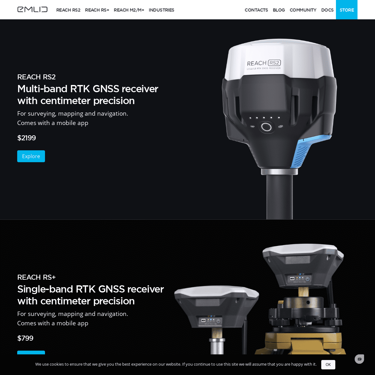
REACH RS2
Multi-band
RTK GNSS receiver
with centimeter
precision
For surveying, mapping and navigation. Comes with a mobile app$2199
Explore
REACH RS+
Single-band
RTK GNSS receiver
with centimeter
precision
For surveying, mapping and navigation. Comes with a mobile app$799
Explore
RTK GNSS modules
for UAV mapping
Positioning with centimeter accuracyin RTK and PPK
Explore
REACH M+
Single-band
Baseline up to 20 km$265
REACH M2
Multi-band
Baseline up to 60 km$499
EMLID NTRIP CASTER
CORRECTIONS OVER THE INTERNET FOR RTK GNSS RECEIVERS Emlid Caster is an easy way to pass RTK corrections between your receivers through the Internet. Our caster works with Reach and any other receivers with NTRIP support. The service is available for free and works worldwide.caster.emlid.com
AUTOPILOT HAT FOR RASPBERRY PI POWERED BY ARDUPILOT AND ROS Navio2 has a great community of experienced engineers, so it’s time to create a special space for it. Check out our new website.navio2.emlid.com
RELIABLE SOLUTION
FOR QUALITY SURVEYING Emlid produces affordable GNSS modules and receivers suitable for RTK and PPK. Highly accurate Reach receivers can work with signals from all the main satellite systems: GPS, GLONASS. They also accept data from BeiDou, QZSS, Galileo. Emlid RTK receivers and modules obtain corrections over LoRa radio, Bluetooth, or NTRIP. Collect points, use the stakeout option, and export data in industry-standard formats. -------------------------REACH
FOR INDUSTRIES
Emlid products are designed to work right out of the box and are suitable for experienced and beginner surveyors. Reach receivers are used for RTK and PPK in such industries as land surveying, precise agriculture, bathymetry, machinery guidance, drone mapping, archaeology, and many others. Our products provide the users with centimeter precision and high accuracy in their collected data with a stable fix solution. Emlid receivers come with a handy app to perform the survey, as well as they are easily integrated with other major surveying apps. ------------------------- ORDER ONLINE IN EMLID STORE For simple, reliable and comfortable purchases, order your Emlid units in the official Emlid store .FIND IN THE STORE
* Reach RS+ and Reach RS2 flagship RTK receivers for a high-accuracy survey * Reach M+/M2 GNSS modules for drone mappingin RTK or PPK modes
* Adapters, hot-shoes, extension pole and other accessories for comfortable surveying * Navio 2 autopilot module for Raspberry Piand ArduPilot
-------------------------HAVE
A QUESTION?
If you have questions about Emlid’s GNSS receivers, contact the Support team or surf theCommunity Forum .
Industries
PPK Mapping Archaeology GCPs fordrone mapping
Products
Reach RS2 Reach RS+ Reach M2/M+Caster
Shop
Online Store Dealers Education Program Affiliate ProgramSupport
Documentation CommunityCorporate
Blog Events Contact UsSubscribe
Get news about Emlid devices, features, events, new services, anddiscounts
� 2021 Emlid Ltd
Privacy policy info@emlid.com We use cookies to ensure that we give you the best experience on our website. If you continue to use this site we will assume that you arehappy with it.Ok
Details
2