3
More Annotations


2


3
Favourite Annotations


6


2
Text
BIVOUAC HOMEROADSARTICLESJUSTIN BROWNMOUNT WADDINGTON SUMMIT IN
WINTERCONTACT US
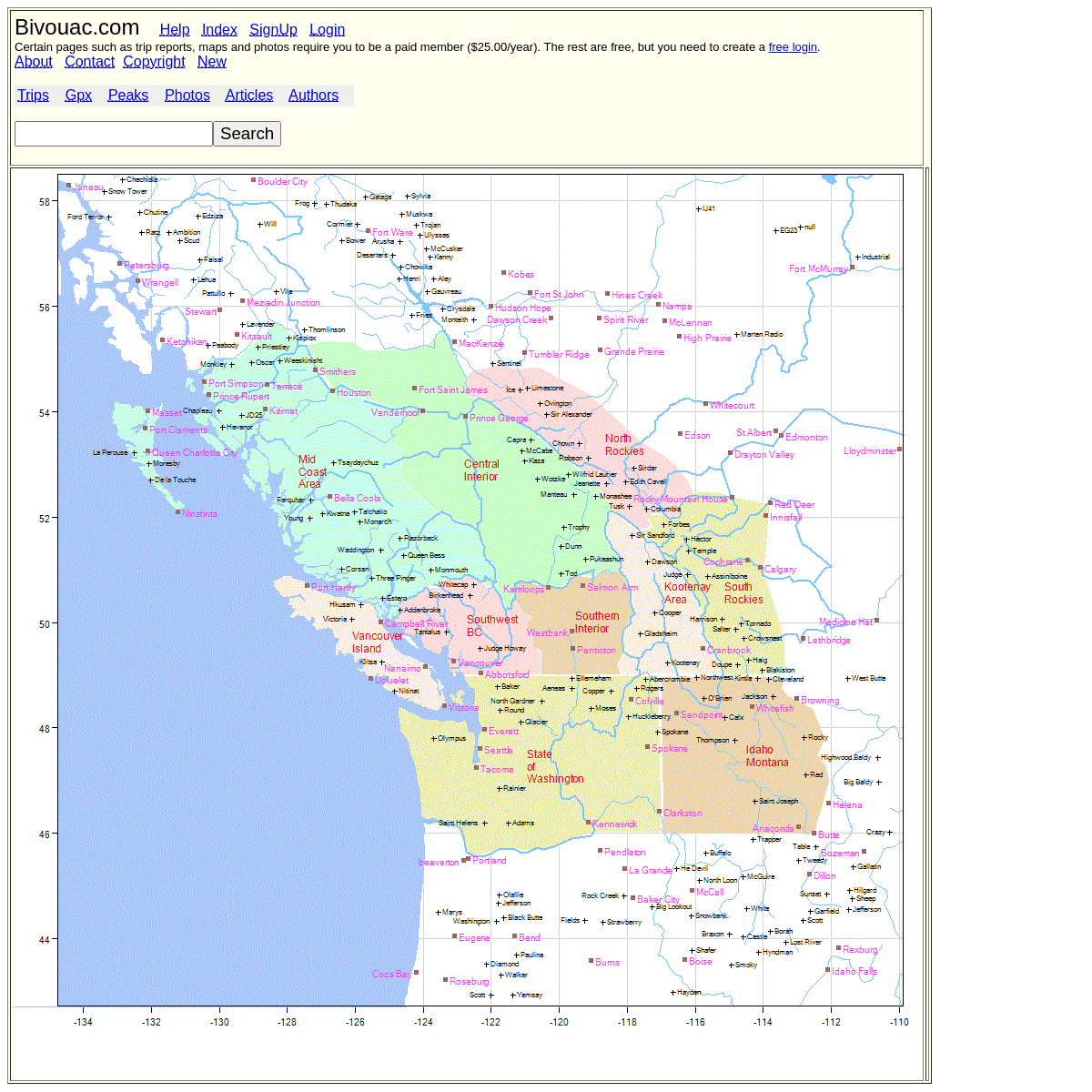
Bivouac.com Help Index SignUp Login Certain pages such as trip reports, maps and photos require you to be a paid member ($25.00/year). The rest are free, but you needFTRPG.ASP - BIVOUAC
Bivouac.com Home Help Index SignUp Login Chek Canyon Recreation Site #4406 (Check Canyon) Type: Camp_Car Elevation: 460 m (1509 ft) Location: 49.91017,-123.15594 49:54:37, -123:09:21 10U 488803 5528654 (10 km W of Garibaldi Lake). (16 km N of Brackendale). (6 km SE of Cloudburst Mountain).TSXLIST.ASP
9. Anything to do with cars and mountain driving. Tire Chains, etc. Avalanche. 28. Any article related to avalanches, including avalanche prevention. Avalanche Beacons. 2. WRONG LAKES DID EXIST IN PAST Bivouac.com Home Help Index SignUp Login Wrong lakes did exist in past Date: 2021.05.13. Back To Trip: Seed and Gilespie Peaks from Mamquam Roads Inserted by: Klaus Haring Added link to my photo Mount Gillespie and the migrating lake with comments about shifting lake locations.Mount Gillespie and the migrating lake with comments aboutshifting lake
TRIO CREEK ROAD #2095 Bivouac.com Home Help Index SignUp Login Trio Creek Road #2095 Length: 7.30 km Class:Spur1 General Route: Around Km 50 on the Harrison West FSR, Trio Creek road heads up the valley on the north side of GraingerPeak.
MOUNT ROACH
Located at the far eastern reaches of the Stein Valley Ecological Reserve. It sits north of Nikaia Mountain and between the two forks of Stryen Creek. The area surrounding Mount Roach was of great mining interest over a century ago and there are supposedly remains of a few old settlements and a mining camp strewn about the MOUNT JIMMY JIMMY AND SIGURD LAKE # 10252 Mount Jimmy Jimmy and Sigurd Lake # 10252. Below is a description of the photograph you were looking for, and the circumstances surrounding the photo. Date: 2007.09.08. Vantage Point: From a subsummit (Regin Peak) 1 km southwest of Sigurd Peak. Caption: The massif of Mt. Jimmy Jimmy makes a nice backdrop for Sigurd Lake. LECKIE PEAK FROM NE # 16095 Leckie Peak from NE # 16095. Below is a description of the photograph you were looking for, and the circumstances surrounding the photo. Date: 1991.10.12. Vantage Point: Valley south of Leckie Cr. Caption: Leckie Peak from beginning of hanging valley. PhotoDescr: This was my first view of Leckie Peak from the beginning of the hanging valley VIBRAM SOLE REPLACEMENT Vibram Sole Replacement - Reference Manual. Trail Hiking ($200-400) A lighter boot (800g in size 11), to be used mostly on day trips on trails. The main distinction here is these boots are lighter, and a bit lower, and very flexible, and inexpensive. They often have anupper made of
ERNIE MCEACHERN
Bivouac.com Home Help Index SignUp Login Ernie McEachern #3467 (white rock, British Columbia, Canada) BIVOUAC HOMEROADSARTICLESJUSTIN BROWNMOUNT WADDINGTON SUMMIT INWINTERCONTACT US
Bivouac.com Help Index SignUp Login Certain pages such as trip reports, maps and photos require you to be a paid member ($25.00/year). The rest are free, but you need CHEAM RANGE (FOUR SISTERS) Bivouac.com Home Help Index SignUp Login Cheam Range (Four Sisters) Parent Area: Skagit Range Area: 113 sq km. Location: The Cheam range starts on the southeast side of the Fraser Valley near Bridal Falls and continues east to the headwaters of Foley Creek.FTRPG.ASP - BIVOUAC
Bivouac.com Home Help Index SignUp Login Chek Canyon Recreation Site #4406 (Check Canyon) Type: Camp_Car Elevation: 460 m (1509 ft) Location: 49.91017,-123.15594 49:54:37, -123:09:21 10U 488803 5528654 (10 km W of Garibaldi Lake). (16 km N of Brackendale). (6 km SE of Cloudburst Mountain). WRONG LAKES DID EXIST IN PAST Bivouac.com Home Help Index SignUp Login Wrong lakes did exist in past Date: 2021.05.13. Back To Trip: Seed and Gilespie Peaks from Mamquam Roads Inserted by: Klaus Haring Added link to my photo Mount Gillespie and the migrating lake with comments about shifting lake locations.Mount Gillespie and the migrating lake with comments aboutshifting lake
TRIO CREEK ROAD #2095 Bivouac.com Home Help Index SignUp Login Trio Creek Road #2095 Length: 7.30 km Class:Spur1 General Route: Around Km 50 on the Harrison West FSR, Trio Creek road heads up the valley on the north side of GraingerPeak.
MOUNT ROACH
Located at the far eastern reaches of the Stein Valley Ecological Reserve. It sits north of Nikaia Mountain and between the two forks of Stryen Creek. The area surrounding Mount Roach was of great mining interest over a century ago and there are supposedly remains of a few old settlements and a mining camp strewn about the VIBRAM SOLE REPLACEMENT Vibram Sole Replacement - Reference Manual. Trail Hiking ($200-400) A lighter boot (800g in size 11), to be used mostly on day trips on trails. The main distinction here is these boots are lighter, and a bit lower, and very flexible, and inexpensive. They often have anupper made of
LECKIE PEAK FROM NE # 16095 Leckie Peak from NE # 16095. Below is a description of the photograph you were looking for, and the circumstances surrounding the photo. Date: 1991.10.12. Vantage Point: Valley south of Leckie Cr. Caption: Leckie Peak from beginning of hanging valley. PhotoDescr: This was my first view of Leckie Peak from the beginning of the hanging valley MOUNT JIMMY JIMMY AND SIGURD LAKE # 10252 Mount Jimmy Jimmy and Sigurd Lake # 10252. Below is a description of the photograph you were looking for, and the circumstances surrounding the photo. Date: 2007.09.08. Vantage Point: From a subsummit (Regin Peak) 1 km southwest of Sigurd Peak. Caption: The massif of Mt. Jimmy Jimmy makes a nice backdrop for Sigurd Lake.ERNIE MCEACHERN
Bivouac.com Home Help Index SignUp Login Ernie McEachern #3467 (white rock, British Columbia, Canada) NEW2.ASP - BIVOUAC.COM InsertDate RbDate RoadName Bulletin Title; Jun 04: 2021.05.31 #9697 Old Cabin Trail Howe Sound Group: Please support the website by becoming a paid member to see bulletin infoTSXLIST.ASP
9. Anything to do with cars and mountain driving. Tire Chains, etc. Avalanche. 28. Any article related to avalanches, including avalanche prevention. Avalanche Beacons. 2. WRONG LAKES DID EXIST IN PAST Bivouac.com Home Help Index SignUp Login Wrong lakes did exist in past Date: 2021.05.13. Back To Trip: Seed and Gilespie Peaks from Mamquam Roads Inserted by: Klaus Haring Added link to my photo Mount Gillespie and the migrating lake with comments about shifting lake locations.Mount Gillespie and the migrating lake with comments aboutshifting lake
FTRPG.ASP - BIVOUAC
Bivouac.com Home Help Index SignUp Login Olive Hut #187 (Catamount Hut) Type: Building_Hut Elevation: 2670 m (8760 ft) Location: 50.63165,-116.55769 50:37:54, -116:33:28 11U 531282 5608958 (31 km W of Edgewater). (2 km N of Gwendoline Mountain). Club maintained cabin, fully equipped. Stone hut HOWE SOUND - BIVOUAC Howe Sound. From Horseshoe bay, up the east side of Howe Sound to Squamish, then up the Mamquam and over a short pass to Boise Creek and down to the Pitt River and to Alvin. Then down the Pitt to the Fraser, and down to Port Coquitlam. Then over a low pass to Port Moody and along the north shore of Burrard Inlet and back to Horseshoe bay.HALT.ASP - BIVOUAC
Bivouac.com Home Help Index SignUp Login. Message Rstr5: Must be a paid user to use the AuthorMenu3.asp module. Create a free login record, then convert it to paid. Return to original page CRANBERRY MOUNTAIN NORTHEAST FACE # 7510 Bivouac.com Home Help Index SignUp Login Cranberry Mountain Northeast Face # 7510. Below is a description of the photograph you were looking for, and the circumstances surrounding the photo.NORTH FROM SUN GOD
Bivouac.com Home Help Index SignUp Login North From Sun God - Cadwallader Range # 3306. Below is a description of the photograph you were looking for, and the circumstances surrounding the photo. PEAKS ABOVE THE APPA GLACIER # 11875 Bivouac.com Home Help Index SignUp Login Peaks Above the Appa Glacier # 11875. Below is a description of the photograph you were looking for, and the circumstances surrounding the photo. PEARSON RIDGE LOOKING SW TO MOUNT SLOAN Bivouac.com Home Help Index SignUp Login Pearson Ridge looking SW to Mount Sloan # 17607. Below is a description of the photograph you were looking for, and the circumstances surrounding the photo. Bivouac.com Help IndexSignUp Login
Certain pages such as trip reports, maps and photos require you to be a paid member ($25.00/year). The rest are free, but you need to createa free login .
About Contact CopyrightNew
Trips Gpx Peaks Photos ArticlesAuthors
Details
1