6
More Annotations


5


6
Favourite Annotations


4


1
Text
ANTONINE WALL
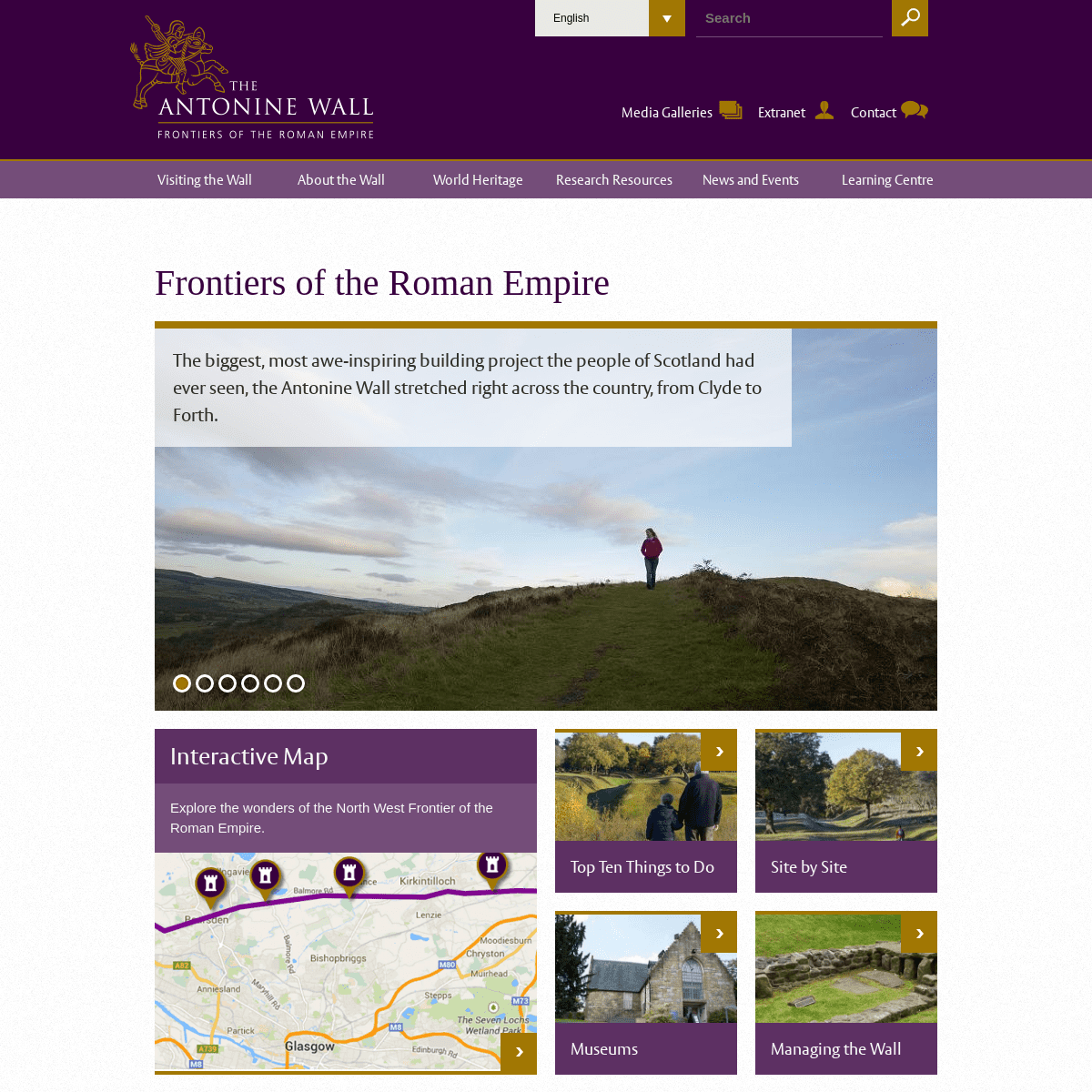
The biggest, most awe-inspiring building project the people of Scotland had ever seen, the Antonine Wall stretched right across the country, from Clyde to Forth. Constructed around 142 AD by the Romans to mark the north-west frontier of their empire, the Wall was a mighty symbol of their power and authority. The route made the most oflandscape
SITE BY SITE
On a high plateau on the east side of Croy Hill, North Lanarkshire, is the site of a Roman fort, fortlet, and probable temporary camp on the Antonine Wall. Two Roman temporary camps were located at Dullatur about 400m south of the Antonine Wall, between the forts at Croy Hilland Westerwood.
SITE BY SITE
Continuing Professional Development . Hazard Planning . Use the interactive map to explore the surviving sites along the line of the Antonine Wall, or discover some of its incredible objects in one of the many museum collections. + -. TOP TEN THINGS TO DO If you can only visit one Antonine Wall location, make it Rough Castle. This site features the best-preserved fort, with defences and an annexe, as well as the tallest surviving portion of Antonine Wall Rampart, excellent Ditch profiles, and the only known example of liliadefensive pits.
PEEL PARK, KIRKINTILLOCH Peel Park in Kirkintilloch marks the site of a Roman fort on the Antonine Wall. Nothing of the fort is clearly visible on the ground today, but the site is well worth a visit because of the nearby Auld Kirk Museum.. Within Peel Park are the visible remains of a later medieval motte, known as the Peel and the stone Kirkintilloch Castle which were constructed over the remains of the AntonineROMAN FRONTIERS
The Antonine Wall is just one small part of this extensive system of frontiers across the edges of the former Roman empire. Sections of this vast system of frontiers can still be seen across Europe, in Austria, Belgium, Bulgaria, Croatia, Germany, Hungary, the Netherlands, Romania, Serbia, Slovakia, Slovenia, Switzerland, and theUnited Kingdom.
ROUGH CASTLE, BONNYBRIDGE Rough Castle is signposted at Bonnybridge, and then along a quiet side road from the B816 between Bonnybridge and High Bonnybridge. There is a small car park at the end of this road. Alternatively, park at the Falkirk Wheel, then follow the signposted path up from the visitor centre, a walk of about 15 minutes.POLMONT WOODS
At the north end of Polmont Woods lies a section of Antonine Wall ditch and outer mound. The line of the wall is accessible through the woods a short distance south of the car park and is somewhat obscured by trees. The ditch is relatively easy to trace as a hollow running north-west from the east end of the wood toward the Millhall Burn. CASTLECARY | ANTONINE WALL The site of a Roman fort and annexe can be visited at Castlecary. It is one of only two forts along the wall to have featured stone ramparts. Visible remains include a low mound and portions of exposed stonework from the fort’s east rampart, small portions of the headquarters building near a cluster of trees within the centre of the fort, and, depending on the current height of grass, traces NETHERCROY ROMAN HEAD SCULPTURE: ARTIST COMMISSION The development of designs for the sculpture will be subject to design approval by the key stakeholders, client and LUC. 1. The piece should have a commanding presence at the path junction above the small car parking area. It will become an iconic image promoting the presence of the Antonine Wall in the Nethercroy area. 2.ANTONINE WALL
The biggest, most awe-inspiring building project the people of Scotland had ever seen, the Antonine Wall stretched right across the country, from Clyde to Forth. Constructed around 142 AD by the Romans to mark the north-west frontier of their empire, the Wall was a mighty symbol of their power and authority. The route made the most oflandscape
SITE BY SITE
On a high plateau on the east side of Croy Hill, North Lanarkshire, is the site of a Roman fort, fortlet, and probable temporary camp on the Antonine Wall. Two Roman temporary camps were located at Dullatur about 400m south of the Antonine Wall, between the forts at Croy Hilland Westerwood.
SITE BY SITE
Continuing Professional Development . Hazard Planning . Use the interactive map to explore the surviving sites along the line of the Antonine Wall, or discover some of its incredible objects in one of the many museum collections. + -. TOP TEN THINGS TO DO If you can only visit one Antonine Wall location, make it Rough Castle. This site features the best-preserved fort, with defences and an annexe, as well as the tallest surviving portion of Antonine Wall Rampart, excellent Ditch profiles, and the only known example of liliadefensive pits.
PEEL PARK, KIRKINTILLOCH Peel Park in Kirkintilloch marks the site of a Roman fort on the Antonine Wall. Nothing of the fort is clearly visible on the ground today, but the site is well worth a visit because of the nearby Auld Kirk Museum.. Within Peel Park are the visible remains of a later medieval motte, known as the Peel and the stone Kirkintilloch Castle which were constructed over the remains of the AntonineROMAN FRONTIERS
The Antonine Wall is just one small part of this extensive system of frontiers across the edges of the former Roman empire. Sections of this vast system of frontiers can still be seen across Europe, in Austria, Belgium, Bulgaria, Croatia, Germany, Hungary, the Netherlands, Romania, Serbia, Slovakia, Slovenia, Switzerland, and theUnited Kingdom.
ROUGH CASTLE, BONNYBRIDGE Rough Castle is signposted at Bonnybridge, and then along a quiet side road from the B816 between Bonnybridge and High Bonnybridge. There is a small car park at the end of this road. Alternatively, park at the Falkirk Wheel, then follow the signposted path up from the visitor centre, a walk of about 15 minutes.POLMONT WOODS
At the north end of Polmont Woods lies a section of Antonine Wall ditch and outer mound. The line of the wall is accessible through the woods a short distance south of the car park and is somewhat obscured by trees. The ditch is relatively easy to trace as a hollow running north-west from the east end of the wood toward the Millhall Burn. CASTLECARY | ANTONINE WALL The site of a Roman fort and annexe can be visited at Castlecary. It is one of only two forts along the wall to have featured stone ramparts. Visible remains include a low mound and portions of exposed stonework from the fort’s east rampart, small portions of the headquarters building near a cluster of trees within the centre of the fort, and, depending on the current height of grass, traces NETHERCROY ROMAN HEAD SCULPTURE: ARTIST COMMISSION The development of designs for the sculpture will be subject to design approval by the key stakeholders, client and LUC. 1. The piece should have a commanding presence at the path junction above the small car parking area. It will become an iconic image promoting the presence of the Antonine Wall in the Nethercroy area. 2.SITE BY SITE
On a high plateau on the east side of Croy Hill, North Lanarkshire, is the site of a Roman fort, fortlet, and probable temporary camp on the Antonine Wall. Two Roman temporary camps were located at Dullatur about 400m south of the Antonine Wall, between the forts at Croy Hilland Westerwood.
TOP TEN THINGS TO DO If you can only visit one Antonine Wall location, make it Rough Castle. This site features the best-preserved fort, with defences and an annexe, as well as the tallest surviving portion of Antonine Wall Rampart, excellent Ditch profiles, and the only known example of liliadefensive pits.
HISTORY | ANTONINE WALL The Antonine Wall’s history is part of a much broader story that includes at least four phases: The Roman invasions and occupation of Britain; the late Roman Iron Age and medieval era in which people (including local inhabitants) were at least partially aware of the Roman remains and attempted to account for them within their own contemporary contexts; the antiquarian era in which the Wall CASTLECARY | ANTONINE WALL The site of a Roman fort and annexe can be visited at Castlecary. It is one of only two forts along the wall to have featured stone ramparts. Visible remains include a low mound and portions of exposed stonework from the fort’s east rampart, small portions of the headquarters building near a cluster of trees within the centre of the fort, and, depending on the current height of grass, traces SUGGESTED ROUTES ALONG THE WALL Download one of our suggested trips below which have details on how to get from site to site, as well as some background information on each location. Show. Driving Guide EAST. A driving guide to the east end of the Wall, in the Falkirk area. Download file.WATLING LODGE
Near this portion of ditch, in the garden of Watling Lodge was an Antonine Wall fortlet, but no visible traces survive. A short distance to the south, in an open field between the Union Canal and Tamfourhill Wood, is the site of a Roman temporary camp, which is sometimes visible in aerial photographs, but which cannot be seen on the groundtoday.
CROY HILL | ANTONINE WALL On a high plateau on the east side of Croy Hill, North Lanarkshire, is the site of a Roman fort, fortlet, and probable temporary camp on the Antonine Wall. The fort, fortlet, and temporary camp are not visible on the ground today, but the Antonine Wall ditch is easily identifiable across much of Croy Hill. You can see where the Romanshad to
KIDS AND FAMILY ZONE The kids can let off some steam and get close to nature as you investigate Scotland’s Roman past together. Discover your inner Roman: march like a legionary; play Roman I-spy as you while away the hours on lookout duty; and creep up on each other without being caught by the Roman watchman. Download our helmet and sword beforehand to addto
LEGIONS & AUXILIARY UNITS The Second Cohort of Thracians (cohors II Thracum) was an infantry and cavalry auxiliary unit of about 500 men from modern-day Bulgaria. The unit is known from a tombstone at Mumrills on the Antonine Wall which commemorates the life and death of Nectovelius, son of Vindex, a Brigantian (from modern-day northern England) who died after nine NORTH LANARKSHIRE COUNCIL The Council is responsible for a wide range of services which contribute to the wider management of the Antonine Wall WHS. These include planning, regeneration, tourism, roads and education. Archaeology services are provided to the Council by Rathmell Archaeology. North Lanarkshire Council are also partial landowners ofthe Site with
ANTONINE WALL
The biggest, most awe-inspiring building project the people of Scotland had ever seen, the Antonine Wall stretched right across the country, from Clyde to Forth. Constructed around 142 AD by the Romans to mark the north-west frontier of their empire, the Wall was a mighty symbol of their power and authority. The route made the most oflandscape
TOP TEN THINGS TO DO If you can only visit one Antonine Wall location, make it Rough Castle. This site features the best-preserved fort, with defences and an annexe, as well as the tallest surviving portion of Antonine Wall Rampart, excellent Ditch profiles, and the only known example of liliadefensive pits.
SITE BY SITE
Continuing Professional Development . Hazard Planning . Use the interactive map to explore the surviving sites along the line of the Antonine Wall, or discover some of its incredible objects in one of the many museum collections. + -. PEEL PARK, KIRKINTILLOCH Peel Park in Kirkintilloch marks the site of a Roman fort on the Antonine Wall. Nothing of the fort is clearly visible on the ground today, but the site is well worth a visit because of the nearby Auld Kirk Museum.. Within Peel Park are the visible remains of a later medieval motte, known as the Peel and the stone Kirkintilloch Castle which were constructed over the remains of the AntoninePOLMONT WOODS
At the north end of Polmont Woods lies a section of Antonine Wall ditch and outer mound. The line of the wall is accessible through the woods a short distance south of the car park and is somewhat obscured by trees. The ditch is relatively easy to trace as a hollow running north-west from the east end of the wood toward the Millhall Burn. KIDS AND FAMILY ZONE The kids can let off some steam and get close to nature as you investigate Scotland’s Roman past together. Discover your inner Roman: march like a legionary; play Roman I-spy as you while away the hours on lookout duty; and creep up on each other without being caught by the Roman watchman. Download our helmet and sword beforehand to addto
ROUGH CASTLE, BONNYBRIDGE Rough Castle is signposted at Bonnybridge, and then along a quiet side road from the B816 between Bonnybridge and High Bonnybridge. There is a small car park at the end of this road. Alternatively, park at the Falkirk Wheel, then follow the signposted path up from the visitor centre, a walk of about 15 minutes. CASTLECARY | ANTONINE WALL The site of a Roman fort and annexe can be visited at Castlecary. It is one of only two forts along the wall to have featured stone ramparts. Visible remains include a low mound and portions of exposed stonework from the fort’s east rampart, small portions of the headquarters building near a cluster of trees within the centre of the fort, and, depending on the current height of grass, traces WESTERWOOD | ANTONINE WALL Beyond the west end of the Cumbernauld Airport runway is the site of a Roman fort, where the Westerwood farm lies today. Very little is visible on the ground now, but sections of the fort’s southern defensive ditches may be traced as subtle hollows within the field. An altar, now in Kinneil Museum, was found west of the fort site,dedicated
KIRKINTILLOCH
West Dunbartonshire Council . Managing the FRE . Hadrian's Wall . Upper German-Raetian Limes . Other World Heritage Sites in Scotland . Heart of Neolithic Orkney . New Lanark . St Kilda . The Old and New Towns of Edinburgh .ANTONINE WALL
The biggest, most awe-inspiring building project the people of Scotland had ever seen, the Antonine Wall stretched right across the country, from Clyde to Forth. Constructed around 142 AD by the Romans to mark the north-west frontier of their empire, the Wall was a mighty symbol of their power and authority. The route made the most oflandscape
TOP TEN THINGS TO DO If you can only visit one Antonine Wall location, make it Rough Castle. This site features the best-preserved fort, with defences and an annexe, as well as the tallest surviving portion of Antonine Wall Rampart, excellent Ditch profiles, and the only known example of liliadefensive pits.
SITE BY SITE
Continuing Professional Development . Hazard Planning . Use the interactive map to explore the surviving sites along the line of the Antonine Wall, or discover some of its incredible objects in one of the many museum collections. + -. PEEL PARK, KIRKINTILLOCH Peel Park in Kirkintilloch marks the site of a Roman fort on the Antonine Wall. Nothing of the fort is clearly visible on the ground today, but the site is well worth a visit because of the nearby Auld Kirk Museum.. Within Peel Park are the visible remains of a later medieval motte, known as the Peel and the stone Kirkintilloch Castle which were constructed over the remains of the AntoninePOLMONT WOODS
At the north end of Polmont Woods lies a section of Antonine Wall ditch and outer mound. The line of the wall is accessible through the woods a short distance south of the car park and is somewhat obscured by trees. The ditch is relatively easy to trace as a hollow running north-west from the east end of the wood toward the Millhall Burn. KIDS AND FAMILY ZONE The kids can let off some steam and get close to nature as you investigate Scotland’s Roman past together. Discover your inner Roman: march like a legionary; play Roman I-spy as you while away the hours on lookout duty; and creep up on each other without being caught by the Roman watchman. Download our helmet and sword beforehand to addto
ROUGH CASTLE, BONNYBRIDGE Rough Castle is signposted at Bonnybridge, and then along a quiet side road from the B816 between Bonnybridge and High Bonnybridge. There is a small car park at the end of this road. Alternatively, park at the Falkirk Wheel, then follow the signposted path up from the visitor centre, a walk of about 15 minutes. CASTLECARY | ANTONINE WALL The site of a Roman fort and annexe can be visited at Castlecary. It is one of only two forts along the wall to have featured stone ramparts. Visible remains include a low mound and portions of exposed stonework from the fort’s east rampart, small portions of the headquarters building near a cluster of trees within the centre of the fort, and, depending on the current height of grass, traces WESTERWOOD | ANTONINE WALL Beyond the west end of the Cumbernauld Airport runway is the site of a Roman fort, where the Westerwood farm lies today. Very little is visible on the ground now, but sections of the fort’s southern defensive ditches may be traced as subtle hollows within the field. An altar, now in Kinneil Museum, was found west of the fort site,dedicated
KIRKINTILLOCH
West Dunbartonshire Council . Managing the FRE . Hadrian's Wall . Upper German-Raetian Limes . Other World Heritage Sites in Scotland . Heart of Neolithic Orkney . New Lanark . St Kilda . The Old and New Towns of Edinburgh . TOP TEN THINGS TO DO If you can only visit one Antonine Wall location, make it Rough Castle. This site features the best-preserved fort, with defences and an annexe, as well as the tallest surviving portion of Antonine Wall Rampart, excellent Ditch profiles, and the only known example of liliadefensive pits.
SITE BY SITE
On a high plateau on the east side of Croy Hill, North Lanarkshire, is the site of a Roman fort, fortlet, and probable temporary camp on the Antonine Wall. Two Roman temporary camps were located at Dullatur about 400m south of the Antonine Wall, between the forts at Croy Hilland Westerwood.
PEEL PARK, KIRKINTILLOCH Peel Park in Kirkintilloch marks the site of a Roman fort on the Antonine Wall. Nothing of the fort is clearly visible on the ground today, but the site is well worth a visit because of the nearby Auld Kirk Museum.. Within Peel Park are the visible remains of a later medieval motte, known as the Peel and the stone Kirkintilloch Castle which were constructed over the remains of the AntonineROMAN FRONTIERS
The Antonine Wall is just one small part of this extensive system of frontiers across the edges of the former Roman empire. Sections of this vast system of frontiers can still be seen across Europe, in Austria, Belgium, Bulgaria, Croatia, Germany, Hungary, the Netherlands, Romania, Serbia, Slovakia, Slovenia, Switzerland, and theUnited Kingdom.
ROUGH CASTLE, BONNYBRIDGE Rough Castle is signposted at Bonnybridge, and then along a quiet side road from the B816 between Bonnybridge and High Bonnybridge. There is a small car park at the end of this road. Alternatively, park at the Falkirk Wheel, then follow the signposted path up from the visitor centre, a walk of about 15 minutes. KIDS AND FAMILY ZONE The kids can let off some steam and get close to nature as you investigate Scotland’s Roman past together. Discover your inner Roman: march like a legionary; play Roman I-spy as you while away the hours on lookout duty; and creep up on each other without being caught by the Roman watchman. Download our helmet and sword beforehand to addto
LEGIONS & AUXILIARY UNITS The Second Cohort of Thracians (cohors II Thracum) was an infantry and cavalry auxiliary unit of about 500 men from modern-day Bulgaria. The unit is known from a tombstone at Mumrills on the Antonine Wall which commemorates the life and death of Nectovelius, son of Vindex, a Brigantian (from modern-day northern England) who died after nine TWECHAR | ANTONINE WALL It lies about 300m south of the line of the Antonine Wall. The camp was probably used as a temporary base for the legions who were constructing the Antonine Wall. It has never been excavated. The site lies immediately east of the village of Twechar, in an open field between the church, leisure centre, and the houses on Burnbrae Road. CASTLECARY | ANTONINE WALL The site of a Roman fort and annexe can be visited at Castlecary. It is one of only two forts along the wall to have featured stone ramparts. Visible remains include a low mound and portions of exposed stonework from the fort’s east rampart, small portions of the headquarters building near a cluster of trees within the centre of the fort, and, depending on the current height of grass, tracesWATLING LODGE
Near this portion of ditch, in the garden of Watling Lodge was an Antonine Wall fortlet, but no visible traces survive. A short distance to the south, in an open field between the Union Canal and Tamfourhill Wood, is the site of a Roman temporary camp, which is sometimes visible in aerial photographs, but which cannot be seen on the groundtoday.
SEARCH FORM
Search
EnglishDeutschGàidhlig* Media Galleries
* Extranet
* Contact
x
* Visiting the Wall * Interactive Map * Things to See and Do * Top Ten Things to Do* Site by Site
* Museums and Heritage Centres * Download the App * Suggested Routes Along the Wall * Walking & Cycling Guides* Get Involved
* Playparks
* About the Wall
* The Romans in Scotland * Roman Frontiers * Building the Wall* Materials
* Transport
* Structures
* Legions & Auxiliary Units * Living on the Wall* Soldier
* Civilian
* Child
* Beyond the Wall* Key Artefacts
* The Wall After the Romans* World Heritage
* UNESCO World Heritage Sites * Nomination and Inscription* SOUV
* Buffer Zone
* Managing the Antonine Wall * East Dunbartonshire Council * Falkirk Council * Glasgow City Council * Historic Scotland * North Lanarkshire Council * West Dunbartonshire Council * Managing the FRE* Hadrian's Wall
* Upper German-Raetian Limes * Other World Heritage Sites in Scotland * Heart of Neolithic Orkney* New Lanark
* St Kilda
* The Old and New Towns of Edinburgh * The Forth Bridge* Documents
* Reports
* Glossary of WHS Terms * Research Resources * Objects Database* Bibliography
* Publications
* History
* Archaeological Sites * News and Events * Learning Centre * Kids and Family Zone * Fun Stuff to Download * Links to Other Resources* Digital Game
* Early Years
* Ideas for the Classroom * On Site Activities * Downloadable Resources* Digital Game
* Handling Boxes
* Links to Other Resources* Primary
* Ideas for the Classroom * On Site Activities * Downloadable Resources * Links to Other Resources* Digital Game
* Handling Boxes
* Secondary Education * Ideas for the Classroom * On Site Activities * Downloadable Resources * Links to Other Resources* Digital Game
* Handling Boxes
* Universities and Further Education * Continuing Professional Development * Hazard Planning* Media Galleries
* Extranet
* Contact
YOU ARE HERE
FRONTIERS OF THE ROMAN EMPIRE*
Today, you can explore the traces of ramparts, steep ditches, and the remains of forts and bathhouses – and imagine what life was like for the Romans posted on this remote frontier.*
The biggest, most awe-inspiring building project the people of Scotland had ever seen, the Antonine Wall stretched right across the country, from Clyde to Forth.*
Constructed around 142 AD by the Romans to mark the north-west frontier of their empire, the Wall was a mighty symbol of their powerand authority.
*
The route made the most of landscape features such as ridges, crests and escarpments to create a forbidding and very visible barrier.*
Built, occupied and then abandoned by the Romans in the space of twenty years, the Wall has left its mark on Scotland’s landscape.*
Since 2008, the Antonine Wall has been part of the Frontiers of the Roman Empire World Heritage Site alongside Hadrian’s Wall and theGerman Limes.
*
Today, you can explore the traces of ramparts, steep ditches, and the remains of forts and bathhouses – and imagine what life was like for the Romans posted on this remote frontier.*
The biggest, most awe-inspiring building project the people of Scotland had ever seen, the Antonine Wall stretched right across the country, from Clyde to Forth.* 1
* 2
* 3
* 4
* 5
* 6
* Previous
* Next
*
INTERACTIVE MAP
Explore the wonders of the North West Frontier of the Roman Empire.*
TOP TEN THINGS TO DO*
SITE BY SITE
*
MUSEUMS
*
MANAGING THE WALL
*
OBJECTS DATABASE
*
NEWS & EVENTS
*
BUILDING THE WALL
*
PRIMARY
SOCIAL FEED OF THE @HERITAGEFUNDSCO"REDISCOVERING THE ANTONINE WALL"PROJECT.
ABOUT THE WALL
* The Romans in Scotland* Roman Frontiers
* Building the Wall
* Living on the Wall* Beyond the Wall
* Key Artefacts
* The Wall After the RomansLEARNING CENTRE
* Kids and Family Zone* Early Years
* Primary
* Secondary Education * Universities and Further Education * Continuing Professional Development* Hazard Planning
VISITING THE WALL
* Interactive Map
* Things to See and Do* Download the App
* Suggested Routes Along the Wall * Walking & Cycling Guides* Get Involved
* Playparks
WORLD HERITAGE
* UNESCO World Heritage Sites * Nomination and Inscription * Managing the Antonine Wall* Managing the FRE
* Other World Heritage Sites in Scotland* Documents
* Reports
* Glossary of WHS Terms*
*
*
*
*
*
* Terms & Conditions* Privacy
* SIte Map
Details
4