3
More Annotations


2


5
Favourite Annotations


5


1
Text
GIS LOUNGE - MAPPING AND GEOSPATIAL TECHNOLOGIESLEARN GISMAPSUSING GISJOBSEVENTSSUBSCRIBE GIS Lounge covers research and case studies about geographic information systems, geospatial technologies, maps, and cartography. GIS JOB DESCRIPTIONS GIS is used across a multitude of industries and subject areas. Find user submitted job descriptions for a range of GIS job levels organized by industry. HIGHLIGHT YOUR SKILLS WITH A GIS PORTFOLIO The end product of most GIS projects is a visual output such as a map or an online app. Since most of the work in developing a map or a geospatial application remains hidden to the casual observer, a spatial portfolio is a great way to highlight your geospatial accomplishments, including all the work you did to create that map or
application.
QGIS AND FREE MOBILE APPLICATIONS HOW GIS IS HELPING ELECTRIC CARS ON THE ROAD The use of GIS is becoming of paramount importance in creating infrastructure for electric cars to become more feasible for more people traveling on road. For one, unlike normal vehicles, simply mapping the shortest or fastest route to a destination might not be feasible for an electric car, as it may need to recharge along theway.
THE NEED FOR ETHICS IN GIS The Need For Ethics in GIS. We don’t often think that GIS could have specific ethical issues as an application of objective study or simply for use to understand our world around us. However, critical elements emerge when developing and deploying GIS. For Crampton (1995), GIS should be evaluated based on how information is commoditized or it USING GIS TO ANALYZE PEDESTRIAN ACCESSIBILITY Using GIS to Analyze Pedestrian Accessibility. Generating a talented workforce is not only a goal for corporations but also cities around the world that want to increase their economic potential and contribute a viable tax base to build exciting places. This has also meant using GIS tools to see how well their cities are able to attractyoung
MAPPING AUSTRALIA’S BUSHFIRES Mapping Australia’s Bushfires. Disaster monitoring using GIS tools has been long-utilized. Now, as the recent Australian bushfires highlight, monitoring wildfires using spatial tools and data is of great importance not only to life and property but also to be able to understand how global change will affect such events in the future. USING GIS TO MONITOR THE WEST COAST WILDFIRES FORECASTING FIRE: EARTH OBSERVATION AND GIS GIS LOUNGE - MAPPING AND GEOSPATIAL TECHNOLOGIESLEARN GISMAPSUSING GISJOBSEVENTSSUBSCRIBE GIS Lounge covers research and case studies about geographic information systems, geospatial technologies, maps, and cartography. GIS JOB DESCRIPTIONS GIS is used across a multitude of industries and subject areas. Find user submitted job descriptions for a range of GIS job levels organized by industry. HIGHLIGHT YOUR SKILLS WITH A GIS PORTFOLIO The end product of most GIS projects is a visual output such as a map or an online app. Since most of the work in developing a map or a geospatial application remains hidden to the casual observer, a spatial portfolio is a great way to highlight your geospatial accomplishments, including all the work you did to create that map orapplication.
QGIS AND FREE MOBILE APPLICATIONS HOW GIS IS HELPING ELECTRIC CARS ON THE ROAD The use of GIS is becoming of paramount importance in creating infrastructure for electric cars to become more feasible for more people traveling on road. For one, unlike normal vehicles, simply mapping the shortest or fastest route to a destination might not be feasible for an electric car, as it may need to recharge along theway.
THE NEED FOR ETHICS IN GIS The Need For Ethics in GIS. We don’t often think that GIS could have specific ethical issues as an application of objective study or simply for use to understand our world around us. However, critical elements emerge when developing and deploying GIS. For Crampton (1995), GIS should be evaluated based on how information is commoditized or it USING GIS TO ANALYZE PEDESTRIAN ACCESSIBILITY Using GIS to Analyze Pedestrian Accessibility. Generating a talented workforce is not only a goal for corporations but also cities around the world that want to increase their economic potential and contribute a viable tax base to build exciting places. This has also meant using GIS tools to see how well their cities are able to attractyoung
MAPPING AUSTRALIA’S BUSHFIRES Mapping Australia’s Bushfires. Disaster monitoring using GIS tools has been long-utilized. Now, as the recent Australian bushfires highlight, monitoring wildfires using spatial tools and data is of great importance not only to life and property but also to be able to understand how global change will affect such events in the future. USING GIS TO MONITOR THE WEST COAST WILDFIRES FORECASTING FIRE: EARTH OBSERVATION AND GIS GIS LOUNGE - MAPPING AND GEOSPATIAL TECHNOLOGIES GIS Lounge covers research and case studies about geographic information systems, geospatial technologies, maps, and cartography.DATACUBES IN GIS
Increasingly, Earth observation (EO) data are stored as datacubes, helping to assist the analytical process. In particular, as satellite data often deal with a temporal attributes, datacubes make an ideal way in which data are stored and processed for different analyses, including in machine learning algorithms or statistical procedures operating matrix algebraic equations. GIS DATA OF THE WORLD'S WETLANDS GIS Database of the World’s Wetlands. There are currently 2,185 sites worldwide that the Ramsar Convention considers to be wetlands of international importance representing over 208,597,750 hectares. The United Kingdom has the highest number of Ramsar Sites with 170. The country with the highest collective area of wetlands is Bolivia with OPEN GEOSPATIAL STANDARDS Open Geospatial Standards. Geospatial standards are critical to solving many problems. Standards allow us to share and use data. Standards are likely to evolve to allow new tools such as Spatial Internet of Things (IoT) and spaces such as indoor mapping. The main hurdle to creating and using standards are social than technical. THE GEOGRAPHY NETWORK The Geography Network serves data built with ArcIMS and SDE technology on remote servers. The street map of the Netherlands you can view is actually being served from Rotterdam. The primary component of the Geography Network is an interconnected network of individual agencies hosting data and geoprocessing services. QGIS AND FREE MOBILE APPLICATIONS QGIS, currently the QGIS 3.x series, is a leading open source tool that has become a powerful tool used by researchers, governments, and others. Allows a wide range of spatial analysis with hundreds of plugins to add additional capability. This includes popular plugins for model development, integration with Google Maps, and PostgreSQL.HYDROLOGY AND GIS
Hydrology and GIS. Articles, case studies and online tutorials in the application of GIS in hydrology. With the widespread availability of global and regional datasets, GIS has become a powerful tool in delineating watersheds, analyzing runoff and other applications in hydrology. American Water Resources Association. HOW TO VOLUNTEER YOUR GIS AND CARTOGRAPHY SKILLS This open-source mobile app helps to fill in critical geographic data for the Missing Maps project. Users can swipe through satellite imagery on their mobile devices which provides data to the Missing Maps project so vulnerable areas can be mapped in more detail. These mapped areas are then used to coordinate humanitarian efforts. USING GIS TO MONITOR THE WEST COAST WILDFIRES Using GIS to Monitor the West Coast Wildfires. With fires raging in California, Oregon, and Washington, scientists, activists, geospatial companies, and others are using GIS and spatial data to better inform and protect communities. Data changes quickly and there are a variety of needs that GIS can fulfill during the crisis. USING GIS IN LANDSCAPE ARCHAEOLOGY Using GIS in Landscape Archaeology. Archaeologists were enthusiastic adopters of GIS starting as early as the 1980s, when tools were still relatively difficult to use. Not surprisingly, a discipline where space is critical to understanding ancient settlements and human use of ancient space, GIS has become popular in the field. GIS LOUNGE - MAPPING AND GEOSPATIAL TECHNOLOGIESLEARN GISMAPSUSING GISJOBSEVENTSSUBSCRIBE GIS Lounge covers research and case studies about geographic information systems, geospatial technologies, maps, and cartography. GIS JOB DESCRIPTIONS GIS is used across a multitude of industries and subject areas. Find user submitted job descriptions for a range of GIS job levels organized by industry. OPEN GEOSPATIAL STANDARDS Geospatial standards are critical to solving many problems; Standards allow us to share and use data; Standards are likely to evolve to allow new tools such as Spatial Internet of Things (IoT) and spaces such as indoor mapping; The main hurdle to creating HIGHLIGHT YOUR SKILLS WITH A GIS PORTFOLIO The end product of most GIS projects is a visual output such as a map or an online app. Since most of the work in developing a map or a geospatial application remains hidden to the casual observer, a spatial portfolio is a great way to highlight your geospatial accomplishments, including all the work you did to create that map orapplication.
HOW TO VOLUNTEER YOUR GIS AND CARTOGRAPHY SKILLS Those with GIS and cartography skills that want to volunteer to help out can do so remotely with these calls for actions as mapping non-profits respond to the coronavirus pandemic. HOW GIS IS HELPING ELECTRIC CARS ON THE ROAD The use of GIS is becoming of paramount importance in creating infrastructure for electric cars to become more feasible for more people traveling on road. THE NEED FOR ETHICS IN GIS We don’t often think that GIS could have specific ethical issues as an application of objective study or simply for use to understand our world around us. However, critical elements emerge when developing and deploying GIS. For Crampton (1995), GIS should be evaluated based on how information is commoditized or it is used for surveillance activities that may monitor individuals or USING GIS TO ANALYZE PEDESTRIAN ACCESSIBILITY Nearest school walking distance in Casablanca. Source: Nick Jones, 2018 The assessment of how friendly to walking places are is not new. In fact, among the earliest people to see the benefits of calculating walkability for urban environments were healthcare researchers and those researching the built environment, who were interested in seeing how easy it was to walk in different regions. MAPPING AUSTRALIA’S BUSHFIRES MyFireWatch lets users see where fire hotspots are occurring as well as historic burn areas from the past two years.. Similar to MyFireWatch, Digital Earth Hotspots Australia (https://hotspots.dea.ga.gov.au/) allows users to monitor near real-time events. The online map tools also allows users to layer data, including vegetation or built-up data, to enable one to monitorwhere the
USING GIS TO MONITOR THE WEST COAST WILDFIRES GIS LOUNGE - MAPPING AND GEOSPATIAL TECHNOLOGIESLEARN GISMAPSUSING GISJOBSEVENTSSUBSCRIBE GIS Lounge covers research and case studies about geographic information systems, geospatial technologies, maps, and cartography. GIS JOB DESCRIPTIONS GIS is used across a multitude of industries and subject areas. Find user submitted job descriptions for a range of GIS job levels organized by industry. OPEN GEOSPATIAL STANDARDS Geospatial standards are critical to solving many problems; Standards allow us to share and use data; Standards are likely to evolve to allow new tools such as Spatial Internet of Things (IoT) and spaces such as indoor mapping; The main hurdle to creating HIGHLIGHT YOUR SKILLS WITH A GIS PORTFOLIO The end product of most GIS projects is a visual output such as a map or an online app. Since most of the work in developing a map or a geospatial application remains hidden to the casual observer, a spatial portfolio is a great way to highlight your geospatial accomplishments, including all the work you did to create that map orapplication.
HOW TO VOLUNTEER YOUR GIS AND CARTOGRAPHY SKILLS Those with GIS and cartography skills that want to volunteer to help out can do so remotely with these calls for actions as mapping non-profits respond to the coronavirus pandemic. THE NEED FOR ETHICS IN GIS We don’t often think that GIS could have specific ethical issues as an application of objective study or simply for use to understand our world around us. However, critical elements emerge when developing and deploying GIS. For Crampton (1995), GIS should be evaluated based on how information is commoditized or it is used for surveillance activities that may monitor individuals or HOW GIS IS HELPING ELECTRIC CARS ON THE ROAD The use of GIS is becoming of paramount importance in creating infrastructure for electric cars to become more feasible for more people traveling on road. USING GIS TO ANALYZE PEDESTRIAN ACCESSIBILITY Nearest school walking distance in Casablanca. Source: Nick Jones, 2018 The assessment of how friendly to walking places are is not new. In fact, among the earliest people to see the benefits of calculating walkability for urban environments were healthcare researchers and those researching the built environment, who were interested in seeing how easy it was to walk in different regions. MAPPING AUSTRALIA’S BUSHFIRES MyFireWatch lets users see where fire hotspots are occurring as well as historic burn areas from the past two years.. Similar to MyFireWatch, Digital Earth Hotspots Australia (https://hotspots.dea.ga.gov.au/) allows users to monitor near real-time events. The online map tools also allows users to layer data, including vegetation or built-up data, to enable one to monitorwhere the
USING GIS TO MONITOR THE WEST COAST WILDFIRESDATACUBES IN GIS
Increasingly, Earth observation (EO) data are stored as datacubes, helping to assist the analytical process. In particular, as satellite data often deal with a temporal attributes, datacubes make an ideal way in which data are stored and processed for different analyses, including in machine learning algorithms or statistical procedures operating matrix algebraic equations. GIS DATA OF THE WORLD'S WETLANDS There are currently 2,185 sites worldwide that the Ramsar Convention considers to be wetlands of international importance representing over 208,597,750 hectares. GIS Data for Ramsar sites is available from Wetlands International. QGIS AND FREE MOBILE APPLICATIONS The rise of QGIS has been significant in the last few years as this software, an open source project that started in 2002, has been developed by a broad community.. In a podcast episode on QGIS, Kurt Menke, an expert and author of books on QGIS, highlights its advantages and evolution.. Back in 2005, the tool was mostly a visualization aid for spatial data. UNDERSTANDING LIDAR TECHNOLOGIES LiDAR technologies and markets are rapidly evolving, and IDTechEx are tracking more than one hundred 3D LiDAR companiesworldwide. Each company claims to offer a highly innovative, next-generation product that is superior to competing technologies.Following a period of dedicated research, IDTechEx published a comprehensive analysis of theLiDAR market.
THE NEED FOR ETHICS IN GIS We don’t often think that GIS could have specific ethical issues as an application of objective study or simply for use to understand our world around us. However, critical elements emerge when developing and deploying GIS. For Crampton (1995), GIS should be evaluated based on how information is commoditized or it is used for surveillance activities that may monitor individuals or BIM - INFORMATION AND MANAGEMENT - GIS LOUNGE Building information modeling (BIM) is a managed approach to the collection, creation, collation and exchange of shared intelligent and structured data and information across a project. Its use is growing exponentially across the spectrum and governments are adapting BIM standards into their management systems. SPATIAL DATABASE ENGINES Spatial Database Engines help manage spatial data to provide a quicker retrieval of that data from database engines such as Oracle, SQLSever and Informix. ArcSDE ArcSDE is ESRI's gateway between ArcGIS softwareand IBM DB2,
I'M A.... THE GIS PROFESSION IN ONE WORD When I think about the debate about whether or not GIS is a profession, one aspect that pokes at me is the inability to succinctly sum up the answer to the question, “What do you do?” in one word. When I think about professions, I think about the one HOW TO MAP A SINGLE SET OF COORDINATES USING QGIS If you have a single set of coordinates that you want to map using QGIS, here are step-by-step instructions on how to do that. Point Nemo is a pole of inaccessibility that marks the further location from landin the ocean.
PREPARING FOR A GIS JOB INTERVIEW Having sat on both sides of the table, I know that the interview process can sometimes be an uncomfortable and even painful process. To make matters more difficult, the GIS field requires a broad range of skills ranging from cartographic techniques to programming to relational database management. Acquiring enough depth in any of these areas can seem impossible especially when the GIS LOUNGE - MAPPING AND GEOSPATIAL TECHNOLOGIESLEARN GISMAPSUSING GISJOBSEVENTSSUBSCRIBE GIS Lounge covers research and case studies about geographic information systems, geospatial technologies, maps, and cartography.GIS TIMELINE
GIS Timeline. The early beginnings of GIS occurred in Canada in the 1960s. Roger Tomlinson (1933-2014), commonly referred to as the father of GIS, introduced the concept of geographic information systems to the Canada Land Inventory (CLI) in 1962. Tomlinson was a pioneer in the field of GIS, stating, “The early days of GIS were very lonely. GIS AND UNDERGROUND MINING GIS and Underground Mining. Among areas where GIS has grown to be an effective monitoring and planning tool is in underground mining of mineral resources. In particular, mines can be dangerous places where unexpected gas pockets or collapse could lead to major safety issues. GIS has been utilized to monitor tunnels and areas explored, as it OVERVIEW OF FUZZY LOGIC SITE SELECTION IN GIS Site selection is a type of GIS analysis that is used to determine the best site for something and fuzzy logic is one site selection method. It assigns membership values to locations that range from 0 to 1 and is commonly used to find ideal habitat for plants and animals. This article examines fuzzy logic and explains how and when to use it. THE NEED FOR ETHICS IN GIS The Need For Ethics in GIS. We don’t often think that GIS could have specific ethical issues as an application of objective study or simply for use to understand our world around us. However, critical elements emerge when developing and deploying GIS. For Crampton (1995), GIS should be evaluated based on how information is commoditized or it HOW GIS IS HELPING ELECTRIC CARS ON THE ROAD The use of GIS is becoming of paramount importance in creating infrastructure for electric cars to become more feasible for more people traveling on road. For one, unlike normal vehicles, simply mapping the shortest or fastest route to a destination might not be feasible for an electric car, as it may need to recharge along theway.
WHERE TO FIND GIS DATA FOR HISTORICAL COUNTRY BOUNDARIES Download: NHGIS data. The Atlas of Historical Country Boundaries provides shapefiles and KMZ files for download cover historical country boundaries for the entire US and by state. The data was created in 2010 by the project of the William M. Scholl Center for American History and Culture at The Newberry Library in Chicago. SPATIAL DATA QUALITY: AN INTRODUCTION Spatial Data Quality: An Introduction. Data quality is the degree of data excellency that satisfy the given objective. In other words, completeness of attributes in order to achieve the given task can be termed as Data Quality. Production of data by private sector as well as by various mapping agencies assesses the data quality standards in HOW TO MAP A SINGLE SET OF COORDINATES USING QGIS If you have a single set of coordinates that you want to map using QGIS, here are step-by-step instructions on how to do that. Point Nemo is a pole of inaccessibility that marks the further location from landin the ocean.
MAPPING AUSTRALIA’S BUSHFIRES Mapping Australia’s Bushfires. Disaster monitoring using GIS tools has been long-utilized. Now, as the recent Australian bushfires highlight, monitoring wildfires using spatial tools and data is of great importance not only to life and property but also to be able to understand how global change will affect such events in the future. GIS LOUNGE - MAPPING AND GEOSPATIAL TECHNOLOGIESLEARN GISMAPSUSING GISJOBSEVENTSSUBSCRIBE GIS Lounge covers research and case studies about geographic information systems, geospatial technologies, maps, and cartography.GIS TIMELINE
GIS Timeline. The early beginnings of GIS occurred in Canada in the 1960s. Roger Tomlinson (1933-2014), commonly referred to as the father of GIS, introduced the concept of geographic information systems to the Canada Land Inventory (CLI) in 1962. Tomlinson was a pioneer in the field of GIS, stating, “The early days of GIS were very lonely. GIS AND UNDERGROUND MINING GIS and Underground Mining. Among areas where GIS has grown to be an effective monitoring and planning tool is in underground mining of mineral resources. In particular, mines can be dangerous places where unexpected gas pockets or collapse could lead to major safety issues. GIS has been utilized to monitor tunnels and areas explored, as it OVERVIEW OF FUZZY LOGIC SITE SELECTION IN GIS Site selection is a type of GIS analysis that is used to determine the best site for something and fuzzy logic is one site selection method. It assigns membership values to locations that range from 0 to 1 and is commonly used to find ideal habitat for plants and animals. This article examines fuzzy logic and explains how and when to use it. THE NEED FOR ETHICS IN GIS The Need For Ethics in GIS. We don’t often think that GIS could have specific ethical issues as an application of objective study or simply for use to understand our world around us. However, critical elements emerge when developing and deploying GIS. For Crampton (1995), GIS should be evaluated based on how information is commoditized or it HOW GIS IS HELPING ELECTRIC CARS ON THE ROAD The use of GIS is becoming of paramount importance in creating infrastructure for electric cars to become more feasible for more people traveling on road. For one, unlike normal vehicles, simply mapping the shortest or fastest route to a destination might not be feasible for an electric car, as it may need to recharge along theway.
WHERE TO FIND GIS DATA FOR HISTORICAL COUNTRY BOUNDARIES Download: NHGIS data. The Atlas of Historical Country Boundaries provides shapefiles and KMZ files for download cover historical country boundaries for the entire US and by state. The data was created in 2010 by the project of the William M. Scholl Center for American History and Culture at The Newberry Library in Chicago. SPATIAL DATA QUALITY: AN INTRODUCTION Spatial Data Quality: An Introduction. Data quality is the degree of data excellency that satisfy the given objective. In other words, completeness of attributes in order to achieve the given task can be termed as Data Quality. Production of data by private sector as well as by various mapping agencies assesses the data quality standards in HOW TO MAP A SINGLE SET OF COORDINATES USING QGIS If you have a single set of coordinates that you want to map using QGIS, here are step-by-step instructions on how to do that. Point Nemo is a pole of inaccessibility that marks the further location from landin the ocean.
MAPPING AUSTRALIA’S BUSHFIRES Mapping Australia’s Bushfires. Disaster monitoring using GIS tools has been long-utilized. Now, as the recent Australian bushfires highlight, monitoring wildfires using spatial tools and data is of great importance not only to life and property but also to be able to understand how global change will affect such events in the future.DATACUBES IN GIS
Increasingly, Earth observation (EO) data are stored as datacubes, helping to assist the analytical process. In particular, as satellite data often deal with a temporal attributes, datacubes make an ideal way in which data are stored and processed for different analyses, including in machine learning algorithms or statistical procedures operating matrix algebraic equations. GIS AND UNDERGROUND MINING GIS and Underground Mining. Among areas where GIS has grown to be an effective monitoring and planning tool is in underground mining of mineral resources. In particular, mines can be dangerous places where unexpected gas pockets or collapse could lead to major safety issues. GIS has been utilized to monitor tunnels and areas explored, as it FREE ONLINE GEOCODER The online geocoder is built using open GIS data from OpenStreetMap , OpenAdressess, and Who’s on first. Pelias, an open-source geocoder, is used to generate the lat/long coordinates from addresses. To use the geocoder, simply copy and paste a list of locations in the designated box. If the locations for a specific country, select itfrom the
FREE WAYS TO LEARN QGIS Frank Donnelly, Geospatial Data Librarian, offers his materials to his one-day workshop under a Creative Commons license. The main component is a manual, Introduction to GIS Using Open Source Software, as well as exercise data and slides. All materials are free to OPEN GEOSPATIAL STANDARDS Open Geospatial Standards. Geospatial standards are critical to solving many problems. Standards allow us to share and use data. Standards are likely to evolve to allow new tools such as Spatial Internet of Things (IoT) and spaces such as indoor mapping. The main hurdle to creating and using standards are social than technical.QUANTARCTICA
Quantarctica – Free GIS Data for QGIS. Update: January 30, 2021: Version 3.2 of Quantarctica was released today. Quantarctica is a collection of freely downloadable GIS data for Antartica which includes “ community-contributed, peer-reviewed data from ten different scientific themes and a professionally-designed basemap.“.
HIGHLIGHT YOUR SKILLS WITH A GIS PORTFOLIO The end product of most GIS projects is a visual output such as a map or an online app. Since most of the work in developing a map or a geospatial application remains hidden to the casual observer, a spatial portfolio is a great way to highlight your geospatial accomplishments, including all the work you did to create that map orapplication.
GIS AND SUSTAINABLE ENERGY GIS has become a critical planning and management tool for addressing where and how to enable sustainable energy efforts. One persistent problem with developing sustainable energy sources that utilize wind, water, solar, biomass, and thermal energy is FREE SPREADSHEET GEOCODING If you have a spreadsheet such as a Microsoft Excel file containing address or x,y coordinates and you want to make a quick map, BatchGeo is a free and easy online application that will convert your location data and geocode it onto Google Maps. HOW GIS IS HELPING ELECTRIC CARS ON THE ROAD The use of GIS is becoming of paramount importance in creating infrastructure for electric cars to become more feasible for more people traveling on road. For one, unlike normal vehicles, simply mapping the shortest or fastest route to a destination might not be feasible for an electric car, as it may need to recharge along theway.
GIS LOUNGE - MAPPING AND GEOSPATIAL TECHNOLOGIESLEARN GISMAPSUSING GISJOBSEVENTSSUBSCRIBE GIS Lounge covers research and case studies about geographic information systems, geospatial technologies, maps, and cartography.GIS TIMELINE
GIS Timeline. The early beginnings of GIS occurred in Canada in the 1960s. Roger Tomlinson (1933-2014), commonly referred to as the father of GIS, introduced the concept of geographic information systems to the Canada Land Inventory (CLI) in 1962. Tomlinson was a pioneer in the field of GIS, stating, “The early days of GIS were very lonely. GIS AND UNDERGROUND MINING GIS and Underground Mining. Among areas where GIS has grown to be an effective monitoring and planning tool is in underground mining of mineral resources. In particular, mines can be dangerous places where unexpected gas pockets or collapse could lead to major safety issues. GIS has been utilized to monitor tunnels and areas explored, as it OVERVIEW OF FUZZY LOGIC SITE SELECTION IN GIS Site selection is a type of GIS analysis that is used to determine the best site for something and fuzzy logic is one site selection method. It assigns membership values to locations that range from 0 to 1 and is commonly used to find ideal habitat for plants and animals. This article examines fuzzy logic and explains how and when to use it. THE NEED FOR ETHICS IN GIS The Need For Ethics in GIS. We don’t often think that GIS could have specific ethical issues as an application of objective study or simply for use to understand our world around us. However, critical elements emerge when developing and deploying GIS. For Crampton (1995), GIS should be evaluated based on how information is commoditized or it HOW GIS IS HELPING ELECTRIC CARS ON THE ROAD The use of GIS is becoming of paramount importance in creating infrastructure for electric cars to become more feasible for more people traveling on road. For one, unlike normal vehicles, simply mapping the shortest or fastest route to a destination might not be feasible for an electric car, as it may need to recharge along theway.
SPATIAL DATA QUALITY: AN INTRODUCTION Spatial Data Quality: An Introduction. Data quality is the degree of data excellency that satisfy the given objective. In other words, completeness of attributes in order to achieve the given task can be termed as Data Quality. Production of data by private sector as well as by various mapping agencies assesses the data quality standards in WHERE TO FIND GIS DATA FOR HISTORICAL COUNTRY BOUNDARIES Download: NHGIS data. The Atlas of Historical Country Boundaries provides shapefiles and KMZ files for download cover historical country boundaries for the entire US and by state. The data was created in 2010 by the project of the William M. Scholl Center for American History and Culture at The Newberry Library in Chicago. HOW TO MAP A SINGLE SET OF COORDINATES USING QGIS If you have a single set of coordinates that you want to map using QGIS, here are step-by-step instructions on how to do that. Point Nemo is a pole of inaccessibility that marks the further location from landin the ocean.
MAPPING AUSTRALIA’S BUSHFIRES Mapping Australia’s Bushfires. Disaster monitoring using GIS tools has been long-utilized. Now, as the recent Australian bushfires highlight, monitoring wildfires using spatial tools and data is of great importance not only to life and property but also to be able to understand how global change will affect such events in the future. GIS LOUNGE - MAPPING AND GEOSPATIAL TECHNOLOGIESLEARN GISMAPSUSING GISJOBSEVENTSSUBSCRIBE GIS Lounge covers research and case studies about geographic information systems, geospatial technologies, maps, and cartography.GIS TIMELINE
GIS Timeline. The early beginnings of GIS occurred in Canada in the 1960s. Roger Tomlinson (1933-2014), commonly referred to as the father of GIS, introduced the concept of geographic information systems to the Canada Land Inventory (CLI) in 1962. Tomlinson was a pioneer in the field of GIS, stating, “The early days of GIS were very lonely. GIS AND UNDERGROUND MINING GIS and Underground Mining. Among areas where GIS has grown to be an effective monitoring and planning tool is in underground mining of mineral resources. In particular, mines can be dangerous places where unexpected gas pockets or collapse could lead to major safety issues. GIS has been utilized to monitor tunnels and areas explored, as it OVERVIEW OF FUZZY LOGIC SITE SELECTION IN GIS Site selection is a type of GIS analysis that is used to determine the best site for something and fuzzy logic is one site selection method. It assigns membership values to locations that range from 0 to 1 and is commonly used to find ideal habitat for plants and animals. This article examines fuzzy logic and explains how and when to use it. THE NEED FOR ETHICS IN GIS The Need For Ethics in GIS. We don’t often think that GIS could have specific ethical issues as an application of objective study or simply for use to understand our world around us. However, critical elements emerge when developing and deploying GIS. For Crampton (1995), GIS should be evaluated based on how information is commoditized or it HOW GIS IS HELPING ELECTRIC CARS ON THE ROAD The use of GIS is becoming of paramount importance in creating infrastructure for electric cars to become more feasible for more people traveling on road. For one, unlike normal vehicles, simply mapping the shortest or fastest route to a destination might not be feasible for an electric car, as it may need to recharge along theway.
SPATIAL DATA QUALITY: AN INTRODUCTION Spatial Data Quality: An Introduction. Data quality is the degree of data excellency that satisfy the given objective. In other words, completeness of attributes in order to achieve the given task can be termed as Data Quality. Production of data by private sector as well as by various mapping agencies assesses the data quality standards in WHERE TO FIND GIS DATA FOR HISTORICAL COUNTRY BOUNDARIES Download: NHGIS data. The Atlas of Historical Country Boundaries provides shapefiles and KMZ files for download cover historical country boundaries for the entire US and by state. The data was created in 2010 by the project of the William M. Scholl Center for American History and Culture at The Newberry Library in Chicago. HOW TO MAP A SINGLE SET OF COORDINATES USING QGIS If you have a single set of coordinates that you want to map using QGIS, here are step-by-step instructions on how to do that. Point Nemo is a pole of inaccessibility that marks the further location from landin the ocean.
MAPPING AUSTRALIA’S BUSHFIRES Mapping Australia’s Bushfires. Disaster monitoring using GIS tools has been long-utilized. Now, as the recent Australian bushfires highlight, monitoring wildfires using spatial tools and data is of great importance not only to life and property but also to be able to understand how global change will affect such events in the future.DATACUBES IN GIS
Increasingly, Earth observation (EO) data are stored as datacubes, helping to assist the analytical process. In particular, as satellite data often deal with a temporal attributes, datacubes make an ideal way in which data are stored and processed for different analyses, including in machine learning algorithms or statistical procedures operating matrix algebraic equations. GIS AND UNDERGROUND MINING GIS and Underground Mining. Among areas where GIS has grown to be an effective monitoring and planning tool is in underground mining of mineral resources. In particular, mines can be dangerous places where unexpected gas pockets or collapse could lead to major safety issues. GIS has been utilized to monitor tunnels and areas explored, as it FREE ONLINE GEOCODER The online geocoder is built using open GIS data from OpenStreetMap , OpenAdressess, and Who’s on first. Pelias, an open-source geocoder, is used to generate the lat/long coordinates from addresses. To use the geocoder, simply copy and paste a list of locations in the designated box. If the locations for a specific country, select itfrom the
FREE WAYS TO LEARN QGIS Frank Donnelly, Geospatial Data Librarian, offers his materials to his one-day workshop under a Creative Commons license. The main component is a manual, Introduction to GIS Using Open Source Software, as well as exercise data and slides. All materials are free to OPEN GEOSPATIAL STANDARDS Open Geospatial Standards. Geospatial standards are critical to solving many problems. Standards allow us to share and use data. Standards are likely to evolve to allow new tools such as Spatial Internet of Things (IoT) and spaces such as indoor mapping. The main hurdle to creating and using standards are social than technical.QUANTARCTICA
Quantarctica – Free GIS Data for QGIS. Update: January 30, 2021: Version 3.2 of Quantarctica was released today. Quantarctica is a collection of freely downloadable GIS data for Antartica which includes “ community-contributed, peer-reviewed data from ten different scientific themes and a professionally-designed basemap.“.
GIS AND SUSTAINABLE ENERGY GIS has become a critical planning and management tool for addressing where and how to enable sustainable energy efforts. One persistent problem with developing sustainable energy sources that utilize wind, water, solar, biomass, and thermal energy is FREE SPREADSHEET GEOCODING If you have a spreadsheet such as a Microsoft Excel file containing address or x,y coordinates and you want to make a quick map, BatchGeo is a free and easy online application that will convert your location data and geocode it onto Google Maps. WORKING WITH GIS DATA USING PYTHON Adding a background map to plots by using geopandas. Image: Adding a background map to plots, Geopandas.org Spatial Data Analysis. Esri’s python library arcpy enables users to both handle and analyze spatial data by calling some built-in tools which ArcGIS users are familiar with.For someone who would like to start with arcpy, Python Scripting for ArcGIS (Amazon affiliate link) is a HOW GIS IS HELPING ELECTRIC CARS ON THE ROAD The use of GIS is becoming of paramount importance in creating infrastructure for electric cars to become more feasible for more people traveling on road. For one, unlike normal vehicles, simply mapping the shortest or fastest route to a destination might not be feasible for an electric car, as it may need to recharge along theway.
GIS LOUNGE - MAPPING AND GEOSPATIAL TECHNOLOGIESLEARN GISMAPSUSING GISJOBSEVENTSSUBSCRIBE GIS Lounge covers research and case studies about geographic information systems, geospatial technologies, maps, and cartography. GIS JOB LISTING SITES Probably the most well known job posting site. GIS only jobs worldwide (most from USA) are posted daily to this site. GoGeomatics. GoGeomatics is a job site for jobs in GIS (or geomatics as the field is commonly known in Canada). There are separate portals GIS JOB DESCRIPTIONS GIS is used across a multitude of industries and subject areas. Find user submitted job descriptions for a range of GIS job levels organized by industry. FREE ONLINE GEOCODER The online geocoder is built using open GIS data from OpenStreetMap , OpenAdressess, and Who’s on first. Pelias, an open-source geocoder, is used to generate the lat/long coordinates from addresses. To use the geocoder, simply copy and paste a list of locations in the designated box. If the locations for a specific country, select itfrom the
OPEN GEOSPATIAL STANDARDS Open Geospatial Standards. Geospatial standards are critical to solving many problems. Standards allow us to share and use data. Standards are likely to evolve to allow new tools such as Spatial Internet of Things (IoT) and spaces such as indoor mapping. The main hurdle to creating and using standards are social than technical.DATA CAPTURE IN GIS
THE NEED FOR ETHICS IN GIS The Need For Ethics in GIS. We don’t often think that GIS could have specific ethical issues as an application of objective study or simply for use to understand our world around us. However, critical elements emerge when developing and deploying GIS. For Crampton (1995), GIS should be evaluated based on how information is commoditized or it HOW TO CITE GIS MATERIALS How to Cite GIS Materials. When writing a research paper or an article that contains references to GIS data, maps, or other geospatial material, it’s important to include a proper citation crediting the author of the GIS work. Citations vary depending on if the map is a single piece of work, part of a map series, an atlas, or a map that isGIS FILE FORMATS
FORECASTING FIRE: EARTH OBSERVATION AND GIS GIS LOUNGE - MAPPING AND GEOSPATIAL TECHNOLOGIESLEARN GISMAPSUSING GISJOBSEVENTSSUBSCRIBE GIS Lounge covers research and case studies about geographic information systems, geospatial technologies, maps, and cartography. GIS JOB LISTING SITES Probably the most well known job posting site. GIS only jobs worldwide (most from USA) are posted daily to this site. GoGeomatics. GoGeomatics is a job site for jobs in GIS (or geomatics as the field is commonly known in Canada). There are separate portals GIS JOB DESCRIPTIONS GIS is used across a multitude of industries and subject areas. Find user submitted job descriptions for a range of GIS job levels organized by industry. FREE ONLINE GEOCODER The online geocoder is built using open GIS data from OpenStreetMap , OpenAdressess, and Who’s on first. Pelias, an open-source geocoder, is used to generate the lat/long coordinates from addresses. To use the geocoder, simply copy and paste a list of locations in the designated box. If the locations for a specific country, select itfrom the
OPEN GEOSPATIAL STANDARDS Open Geospatial Standards. Geospatial standards are critical to solving many problems. Standards allow us to share and use data. Standards are likely to evolve to allow new tools such as Spatial Internet of Things (IoT) and spaces such as indoor mapping. The main hurdle to creating and using standards are social than technical.DATA CAPTURE IN GIS
THE NEED FOR ETHICS IN GIS The Need For Ethics in GIS. We don’t often think that GIS could have specific ethical issues as an application of objective study or simply for use to understand our world around us. However, critical elements emerge when developing and deploying GIS. For Crampton (1995), GIS should be evaluated based on how information is commoditized or it HOW TO CITE GIS MATERIALS How to Cite GIS Materials. When writing a research paper or an article that contains references to GIS data, maps, or other geospatial material, it’s important to include a proper citation crediting the author of the GIS work. Citations vary depending on if the map is a single piece of work, part of a map series, an atlas, or a map that isGIS FILE FORMATS
FORECASTING FIRE: EARTH OBSERVATION AND GISDATACUBES IN GIS
Increasingly, Earth observation (EO) data are stored as datacubes, helping to assist the analytical process. In particular, as satellite data often deal with a temporal attributes, datacubes make an ideal way in which data are stored and processed for different analyses, including in machine learning algorithms or statistical procedures operating matrix algebraic equations. SUPER-RESOLUTION IMAGING Super-resolutions work by applying deep learning techniques, typically forms of convolution neural networks (CNNs), which are trained with sampling data and can then apply learned models to using existing resolution of pixels.The algorithm can then resample those pixels to FREE ONLINE GEOCODER The online geocoder is built using open GIS data from OpenStreetMap , OpenAdressess, and Who’s on first. Pelias, an open-source geocoder, is used to generate the lat/long coordinates from addresses. To use the geocoder, simply copy and paste a list of locations in the designated box. If the locations for a specific country, select itfrom the
GIS FILE FORMATS
GIS File Formats. There are well over 100 GIS, CAD and Remote Sensing applications on the market. Listed here are some of the more common file formats along with associated file extension (the last 3 charcters after the period in the file name). File formats are categorized as vector, raster, imagery, and legacy GIS file formats. HOW TO CITE GIS MATERIALS How to Cite GIS Materials. When writing a research paper or an article that contains references to GIS data, maps, or other geospatial material, it’s important to include a proper citation crediting the author of the GIS work. Citations vary depending on if the map is a single piece of work, part of a map series, an atlas, or a map that is BIM - INFORMATION AND MANAGEMENT - GIS LOUNGE BIM – Information and Management. Building information modeling (BIM) is a managed approach to the collection, creation, collation and exchange of shared intelligent and structured data and information across a project. Its use is growing exponentially across the spectrum and governments are adapting BIM standards into their managementsystems.
LINE OF SIGHT IN GIS Line of sight in GIS is a phrase used to described the unimpeded view or access from one point to another point across a terrain or surface. Visibility analysis is a spatial analysis of the portions of a line that are visible as opposed to not visible from a starting point. GIS AND SUSTAINABLE ENERGY GIS has become a critical planning and management tool for addressing where and how to enable sustainable energy efforts. One persistent problem with developing sustainable energy sources that utilize wind, water, solar, biomass, and thermal energy is OVERVIEW OF ELEVATION DATA Hypsography, topography, elevation, TINS, and contours. There are many different terms for data relating to elevation. This article reviews some of terminology and types of elevation based datasets available to GIS.Digital elevation data are sets of elevation measurements for locations distributed over the land surface. HOW GIS IS USED IN ALL PHASES OF EMERGENCY MANAGEMENT In this guest article, Brian Sekita discusses how GIS is vital to all phases of the emergency management process. Natural disasters such as hurricanes, floods, tornadoes, earthquakes, and volcanic eruptions have impacted the globe since the beginning of time.__ __
__
__
__
__
* Contact
* Subscribe
* GIS Learning
* GIS Software
* GIS Data
* Maps and Cartography* GPS
* GIS Career and Jobs* Spatial Analysis
* Resources
* Free GIS offerings* GIS Career
* Free Technical Magazines__
* Learn GIS
* What is GIS?
* Learn GIS for Free* GIS Programs
* GIS MOOC and Training List * Programming in GIS* GIS Books
* Maps
* Cartography
* Spatial Analysis
* Using GIS
* Software
* Commercial GIS
* Open Source GIS
* Programming in GIS* Data
* Geospatial Industry * Free Technical Magazines* Free GIS Books
* Free GIS
* GIS Jobs
* GIS Job Listings
* GIS Career Resources* GIS Internships
* GIS Conferences
* Subscribe
* Contact/About
* About
* Contact
* Privacy Policy
* Disclaimer
* Copyright
* Terms of Service
* Advertise
* Submit
__
__ __
__
__
__
Search for: __
*
HOW GIS IS USED IN ALL PHASES OF EMERGENCY MANAGEMENTRead More
In this guest article, Brian Sekita discusses how GIS is vital to all phases of the emergency management process.*
CORONAVIRUS MAP AND DATA HUB DEVELOPED BY ESRIRead More
Esri has launched the COVID-19 GIS Hub to centralize access to maps and GIS data relating to the novel coronavirus.*
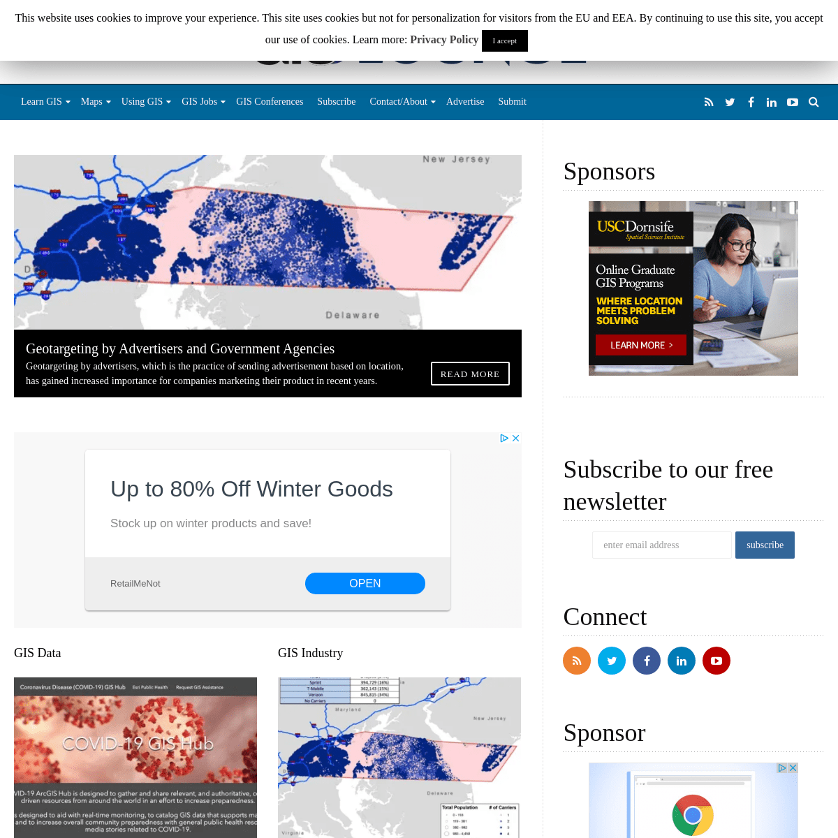
GEOTARGETING BY ADVERTISERS AND GOVERNMENT AGENCIESRead More
Geotargeting by advertisers, which is the practice of sending advertisement based on location, has gained increased importance for companies marketing their product in recent years.*
HOW GIS IS USED IN ALL PHASES OF EMERGENCY MANAGEMENTRead More
In this guest article, Brian Sekita discusses how GIS is vital to all phases of the emergency management process.*
CORONAVIRUS MAP AND DATA HUB DEVELOPED BY ESRIRead More
Esri has launched the COVID-19 GIS Hub to centralize access to maps and GIS data relating to the novel coronavirus.* 1
* 2
* 3
* Previous
* Next
GIS DATA
CORONAVIRUS MAP AND DATA HUB DEVELOPED BY ESRI __February 29, 2020By Caitlin Dempsey__GIS Data
Esri has launched the COVID-19 GIS Hub to centralize access to maps and GIS data relating to the novel coronavirus.Read More »
Read More »
__coronavirus
, epidemic mapping
GIS INDUSTRY
GEOTARGETING BY ADVERTISERS AND GOVERNMENT AGENCIES __February 25, 2020By Mark Altaweel__GIS Industry
Geotargeting by advertisers, which is the practice of sending advertisement based on location, has gained increased importance for companies marketing their product in recent years.Read More »
Read More »
__geomarketing
, geotargeting
GIS INDUSTRY
HOW GIS IS USED IN ALL PHASES OF EMERGENCY MANAGEMENT __February 20, 2020By GIS Contributor__GIS Industry
In this guest article, Brian Sekita discusses how GIS is vital to all phases of the emergency management process.Read More »
Read More »
__emergency
management ,
flood mapping
SPATIAL ANALYSIS
MAPPING THE UNIVERSE __February 18, 2020By Mark Altaweel__Spatial Analysis
New satellite technology achieved in in the last decade are helping scientist to more accurately map the universe.Read More »
Read More » __remotesensing , satellite
data
GIS INDUSTRY
USING GIS TO MAP AND TRACK VANDALISM __February 11, 2020By Mark Altaweel__GIS Industry
GIS is being used to better understand current and potentially future patterns of vandalism.Read More »
Read More »
__Crime
Mapping
GIS INDUSTRY
USING GIS TO ASSESS THE IMPACT OF ELECTRIC CARS __February 5, 2020By Mark Altaweel__GIS Industry
GIS and spatial analysis may help find some practical solutions for electric vehicle charging.Read More »
Read More »
__decision
analysis ,
Multi-criteria modelingGIS INDUSTRY
GIS AND MAP CONTESTS ROUNDUP __February 5, 2020By Caitlin Dempsey__GIS Industry
Current map and GIS related competitions listed in order of the competition deadline.Read More »
Read More »
__geospatial
, GIS competition
, GIS contest
, map competition
, map contest
, remote sensing
SPATIAL ANALYSIS
USING GIS TO ASSESS URBAN TREE CANOPY __February 3, 2020By Caitlin Dempsey__Spatial Analysis
The University of Vermont Spatial Analysis Lab used spatial analysis to map out how the city of Philadelphia’s tree canopy changed between 2008 and 2018.Read More »
Read More »
__urban
foresty
GIS LEARNING
HOW TO ADD LEADER LINES TO LABELS IN QGIS 3.10 __January 30, 2020By Caitlin Dempsey__GIS Learning
The release of QGIS version 3.10 brought with it the native capability to add leader lines to labels.Read More »
Read More »
__GIS
tutorial , QGIS
, QGIS tutorial
SPATIAL ANALYSIS
CLOUD-BASED GEOSPATIAL ANALYSIS __January 29, 2020By Mark Altaweel__Spatial Analysis
We will see more migration of spatial and GIS work to cloud-based platforms in the near future.Read More »
Read More »
__cloud
computing , geospatialanalysis
← Older Posts
SPONSORS
------------------------- SUBSCRIBE TO OUR FREE NEWSLETTERCONNECT
__ __
__
__
__
SPONSOR
-------------------------MAP COLORING BOOK
_CITY MAPS: A COLORING BOOK FOR ADULTS _ is a 94-page book containing 44 maps covering cities from around the world by Gretchen Peterson GEOSPATIAL BOOK PICK _THE LOOK OF MAPS: AN EXAMINATION OF CARTOGRAPHIC DESIGN_
is a cartographic classic by Arthur H. Robinson originally published in 1952. The book was based on Robinson’s doctoral research “which investigated the relationship between science and art in cartography and the resultant refinement of graphic techniques in mapmaking to present dynamic geographic information.” SPONSORED RELATED CONTENT LATEST ON GIS LOUNGE * Coronavirus Map and Data Hub Developed by Esri * Geotargeting by Advertisers and Government Agencies * How GIS is Used in All Phases of Emergency Management * Mapping the Universe * Using GIS to Map and Track Vandalism * Using GIS to Assess the Impact of Electric Cars * GIS and Map Contests Roundup * Using GIS to Assess Urban Tree Canopy * How to Add Leader Lines to Labels in QGIS 3.10 * Cloud-based Geospatial Analysis__ __
__
__
__
* Contact
* About
* Privacy Policy
* Disclaimer
* Submit an Article
* Advertise
* Site Map
� GIS Lounge, 2001-2020 . All rights reserved. No content on this site may be reproduced without prior writtenpermission.
This website uses cookies to improve your experience. This site uses cookies but not for personalization for visitors from the EU and EEA. By continuing to use this site, you accept our use of cookies. Learn more: Privacy Policy Iaccept Reject
Privacy & Cookies PolicyClose
Necessary Always Enabled__
Details
6