3
More Annotations


1


1
Favourite Annotations


4


5
Text
GIS, DRONE MAPPING, LAND SURVEY AND REMOTE SENSING COMPANY No 1 Industry leader in GIS, Drone mapping and land survey, Geospatial Information Tech in Nigeria. We provide GIS service, Drone Inspection, Aerial Surveying, land survey, mapping, Satellite data processing, web solutions associated with geospatial development ONLINE TRAINING AND CERTIFICATE ON GIS PYTHON DRONE PILOT Online Training to get started making maps and apps, apply advanced analysis tools, or automate your GIS and Drone workflows? We’ve got Email
Email
you covered
GIS BENEFIT TO LOGISTICS GIS benefit to Logistics involves the process of planning and executing the efficient transportation and storage of goods from the point of origin to the point of consumption.. Pre-planning:. At Geoinfotech developing system design based on GIS, is what we encourage, to maximize the integration of grid information, providing a more accurate and diversified decision-making basis for LAND SURFACE PROCESS AND REMOTE SENSING Remote sensing offers key tools for the earth and environment observation as well as assessments of effects caused by climate change or global change processes related to urbanization, migrations, or land-use change. It is needed in all environmental disciplines. Remote sensing is a methodology for data collection, analysis and the parameterization of environmental models. TRAINING ON GIS APPLICATIONS IN MARITIME/OCEAN/MARINE 1) GEOGRAPHIC INFORMATION SYSTEM (GIS) 2) DRONE OPERATION AND MAPPING. 3) REMOTE SENSING. 4) DRONE TRAINING FOR BEGINNERS. SELECT TRAINING VENUE *. LAGOS STATE, 1a Akin Osiyemi St, Allen, Ikeja. OSUN STATE, Local Govt Studies, Old Building, OAU, Rd 1 Ife. ABUJA FCT, Work and connect 50 Ebitu Ukiwe St Jabi. Divider. BIODIVERSITY MAPPING Biodiversity Mapping of Galve was carried out 5th of April 2021 and was concluded on the 9th of June 2021. LAND SURVEYING COST IN NIGERIA “”. LAND SURVEY COST IN NIGERIA “We do not intend to provide a survey for just today, but for years to come”. “Better yet, what if I showed you how to leverage cost for surveying your land in Nigeria”. INTRODUCTION TO GEOGRAPHIC INFORMATION SYSTEM GIS Introduction to Geographic Information System GIS ». GIS principles and ArcGIS techniques are implemented in this course to simulate real-world features, explore patterns, and make better decisions. Using ArcMap as you learn fundamental principles that are in GIS technology, you can work with GIS maps, explore data, andanalyze maps
APPLICATION OF GIS IN AGRICULTURE. Application of Gis in agriculture has been playing an increasingly important role in crop production throughout the world.. It has helped farmers in increasing production, reducing costs, and managing their land resources more efficiently. GIS in agriculture helps farmers to achieve increased productivity and reduced costs by enabling better management of land resources. BENEFITS OF GIS IN URBAN PLANNING AND DEVELOPMENT One of the reasons why GIS is important in urban planning is the ability to better understand the current needs of a city, and then design to fulfil those needs, processing geospatial data from satellite imaging, aerial photography and remote sensors, users gain GIS, DRONE MAPPING, LAND SURVEY AND REMOTE SENSING COMPANY No 1 Industry leader in GIS, Drone mapping and land survey, Geospatial Information Tech in Nigeria. We provide GIS service, Drone Inspection, Aerial Surveying, land survey, mapping, Satellite data processing, web solutions associated with geospatial development ONLINE TRAINING AND CERTIFICATE ON GIS PYTHON DRONE PILOT Online Training to get started making maps and apps, apply advanced analysis tools, or automate your GIS and Drone workflows? We’ve gotyou covered
GIS BENEFIT TO LOGISTICS GIS benefit to Logistics involves the process of planning and executing the efficient transportation and storage of goods from the point of origin to the point of consumption.. Pre-planning:. At Geoinfotech developing system design based on GIS, is what we encourage, to maximize the integration of grid information, providing a more accurate and diversified decision-making basis for LAND SURFACE PROCESS AND REMOTE SENSING Remote sensing offers key tools for the earth and environment observation as well as assessments of effects caused by climate change or global change processes related to urbanization, migrations, or land-use change. It is needed in all environmental disciplines. Remote sensing is a methodology for data collection, analysis and the parameterization of environmental models. TRAINING ON GIS APPLICATIONS IN MARITIME/OCEAN/MARINE 1) GEOGRAPHIC INFORMATION SYSTEM (GIS) 2) DRONE OPERATION AND MAPPING. 3) REMOTE SENSING. 4) DRONE TRAINING FOR BEGINNERS. SELECT TRAINING VENUE *. LAGOS STATE, 1a Akin Osiyemi St, Allen, Ikeja. OSUN STATE, Local Govt Studies, Old Building, OAU, Rd 1 Ife. ABUJA FCT, Work and connect 50 Ebitu Ukiwe St Jabi. Divider. BIODIVERSITY MAPPING Biodiversity Mapping of Galve was carried out 5th of April 2021 and was concluded on the 9th of June 2021. LAND SURVEYING COST IN NIGERIA “”. LAND SURVEY COST IN NIGERIA “We do not intend to provide a survey for just today, but for years to come”. “Better yet, what if I showed you how to leverage cost for surveying your land in Nigeria”. INTRODUCTION TO GEOGRAPHIC INFORMATION SYSTEM GIS Introduction to Geographic Information System GIS ». GIS principles and ArcGIS techniques are implemented in this course to simulate real-world features, explore patterns, and make better decisions. Using ArcMap as you learn fundamental principles that are in GIS technology, you can work with GIS maps, explore data, andanalyze maps
APPLICATION OF GIS IN AGRICULTURE. Application of Gis in agriculture has been playing an increasingly important role in crop production throughout the world.. It has helped farmers in increasing production, reducing costs, and managing their land resources more efficiently. GIS in agriculture helps farmers to achieve increased productivity and reduced costs by enabling better management of land resources. BENEFITS OF GIS IN URBAN PLANNING AND DEVELOPMENT One of the reasons why GIS is important in urban planning is the ability to better understand the current needs of a city, and then design to fulfil those needs, processing geospatial data from satellite imaging, aerial photography and remote sensors, users gain COVID-19 | NIGERIA DATA VISUALISATION COVID-19’s effect in Nigeria.The data is from Local Media Coverage, NCDC, WHO. Updates made in real time, using reputable sources fromaround the world.
ONLINE TRAINING AND CERTIFICATE ON GIS PYTHON DRONE PILOT Online Training to get started making maps and apps, apply advanced analysis tools, or automate your GIS and Drone workflows? We’ve gotyou covered
A GEOGRAPHIC DATABASE A geographic database is a database that is associated with a location on the earth in some way. In addition to this data, there is usually data called attribute data. Generally, attribute data is defined as other information that can be associated with spatial data. Divided into two categories: georeferenced data expressed in vector and raster LAND SURVEY IN NIGERIA Land Survey Service At Geoinfotech, the services we provide in Nigeria combine professional staff, advanced equipment, to ensure that we provide comprehensive land survey, topographic survey, engineering survey, hydrological survey, cadastral survey and control survey software.Land Survey in Nigeria GeoinfotechEVOLUTION OF GIS.
GIS has evolved from a concept to a science. The phenomenal evolution of GIS from a crude tool to a modern, powerful platform for understanding and planning ourLAND SURVEYING
Land surveying is the science and profession of determining the positions of points on the surface of the earth and measuring the distances, directions, angles, and elevations between them. LAND SURVEYING COST IN NIGERIA “”. LAND SURVEY COST IN NIGERIA “We do not intend to provide a survey for just today, but for years to come”. “Better yet, what if I showed you how to leverage cost for surveying your land in Nigeria”. WHAT'S NEW ABOUT QGIS QGIS is a desktop geographic information system (GIS) application that supports viewing, editing, and analysis of geospatial data.. QGIS functions as geographic information system (GIS) software, allowing users to analyze and edit spatial information, in APPLICATION OF GIS IN AGRICULTURE. Application of Gis in agriculture has been playing an increasingly important role in crop production throughout the world.. It has helped farmers in increasing production, reducing costs, and managing their land resources more efficiently. GIS in agriculture helps farmers to achieve increased productivity and reduced costs by enabling better management of land resources. MAPPING WITH GIS FOR MARITIME BOUNDARY The course is for those who want to improve and expand their opportunities in geospatial designs and analysis. ESRI ArcGIS pro is the most sourced for Remote sensing and GIS software in the Geospatial industry. Data management analyst has being a very lucrative work in this century with average GIS salary ranging from $40,000 to over$100,000.
GIS, DRONE MAPPING, LAND SURVEY AND REMOTE SENSING COMPANY No 1 Industry leader in GIS, Drone mapping and land survey, Geospatial Information Tech in Nigeria. We provide GIS service, Drone Inspection, Aerial Surveying, land survey, mapping, Satellite data processing, web solutions associated with geospatial development ONLINE TRAINING AND CERTIFICATE ON GIS PYTHON DRONE PILOT Online Training to get started making maps and apps, apply advanced analysis tools, or automate your GIS and Drone workflows? We’ve gotyou covered
GIS BENEFIT TO LOGISTICS GIS benefit to Logistics involves the process of planning and executing the efficient transportation and storage of goods from the point of origin to the point of consumption.. Pre-planning:. At Geoinfotech developing system design based on GIS, is what we encourage, to maximize the integration of grid information, providing a more accurate and diversified decision-making basis for LAND SURFACE PROCESS AND REMOTE SENSING Remote sensing offers key tools for the earth and environment observation as well as assessments of effects caused by climate change or global change processes related to urbanization, migrations, or land-use change. It is needed in all environmental disciplines. Remote sensing is a methodology for data collection, analysis and the parameterization of environmental models. TRAINING ON GIS APPLICATIONS IN MARITIME/OCEAN/MARINE 1) GEOGRAPHIC INFORMATION SYSTEM (GIS) 2) DRONE OPERATION AND MAPPING. 3) REMOTE SENSING. 4) DRONE TRAINING FOR BEGINNERS. SELECT TRAINING VENUE *. LAGOS STATE, 1a Akin Osiyemi St, Allen, Ikeja. OSUN STATE, Local Govt Studies, Old Building, OAU, Rd 1 Ife. ABUJA FCT, Work and connect 50 Ebitu Ukiwe St Jabi. Divider. BIODIVERSITY MAPPING Biodiversity Mapping of Galve was carried out 5th of April 2021 and was concluded on the 9th of June 2021. LAND SURVEYING COST IN NIGERIA “”. LAND SURVEY COST IN NIGERIA “We do not intend to provide a survey for just today, but for years to come”. “Better yet, what if I showed you how to leverage cost for surveying your land in Nigeria”. INTRODUCTION TO GEOGRAPHIC INFORMATION SYSTEM GIS Introduction to Geographic Information System GIS ». GIS principles and ArcGIS techniques are implemented in this course to simulate real-world features, explore patterns, and make better decisions. Using ArcMap as you learn fundamental principles that are in GIS technology, you can work with GIS maps, explore data, andanalyze maps
APPLICATION OF GIS IN AGRICULTURE. Application of Gis in agriculture has been playing an increasingly important role in crop production throughout the world.. It has helped farmers in increasing production, reducing costs, and managing their land resources more efficiently. GIS in agriculture helps farmers to achieve increased productivity and reduced costs by enabling better management of land resources. BENEFITS OF GIS IN URBAN PLANNING AND DEVELOPMENT One of the reasons why GIS is important in urban planning is the ability to better understand the current needs of a city, and then design to fulfil those needs, processing geospatial data from satellite imaging, aerial photography and remote sensors, users gain GIS, DRONE MAPPING, LAND SURVEY AND REMOTE SENSING COMPANY No 1 Industry leader in GIS, Drone mapping and land survey, Geospatial Information Tech in Nigeria. We provide GIS service, Drone Inspection, Aerial Surveying, land survey, mapping, Satellite data processing, web solutions associated with geospatial development ONLINE TRAINING AND CERTIFICATE ON GIS PYTHON DRONE PILOT Online Training to get started making maps and apps, apply advanced analysis tools, or automate your GIS and Drone workflows? We’ve gotyou covered
GIS BENEFIT TO LOGISTICS GIS benefit to Logistics involves the process of planning and executing the efficient transportation and storage of goods from the point of origin to the point of consumption.. Pre-planning:. At Geoinfotech developing system design based on GIS, is what we encourage, to maximize the integration of grid information, providing a more accurate and diversified decision-making basis for LAND SURFACE PROCESS AND REMOTE SENSING Remote sensing offers key tools for the earth and environment observation as well as assessments of effects caused by climate change or global change processes related to urbanization, migrations, or land-use change. It is needed in all environmental disciplines. Remote sensing is a methodology for data collection, analysis and the parameterization of environmental models. TRAINING ON GIS APPLICATIONS IN MARITIME/OCEAN/MARINE 1) GEOGRAPHIC INFORMATION SYSTEM (GIS) 2) DRONE OPERATION AND MAPPING. 3) REMOTE SENSING. 4) DRONE TRAINING FOR BEGINNERS. SELECT TRAINING VENUE *. LAGOS STATE, 1a Akin Osiyemi St, Allen, Ikeja. OSUN STATE, Local Govt Studies, Old Building, OAU, Rd 1 Ife. ABUJA FCT, Work and connect 50 Ebitu Ukiwe St Jabi. Divider. BIODIVERSITY MAPPING Biodiversity Mapping of Galve was carried out 5th of April 2021 and was concluded on the 9th of June 2021. LAND SURVEYING COST IN NIGERIA “”. LAND SURVEY COST IN NIGERIA “We do not intend to provide a survey for just today, but for years to come”. “Better yet, what if I showed you how to leverage cost for surveying your land in Nigeria”. INTRODUCTION TO GEOGRAPHIC INFORMATION SYSTEM GIS Introduction to Geographic Information System GIS ». GIS principles and ArcGIS techniques are implemented in this course to simulate real-world features, explore patterns, and make better decisions. Using ArcMap as you learn fundamental principles that are in GIS technology, you can work with GIS maps, explore data, andanalyze maps
APPLICATION OF GIS IN AGRICULTURE. Application of Gis in agriculture has been playing an increasingly important role in crop production throughout the world.. It has helped farmers in increasing production, reducing costs, and managing their land resources more efficiently. GIS in agriculture helps farmers to achieve increased productivity and reduced costs by enabling better management of land resources. BENEFITS OF GIS IN URBAN PLANNING AND DEVELOPMENT One of the reasons why GIS is important in urban planning is the ability to better understand the current needs of a city, and then design to fulfil those needs, processing geospatial data from satellite imaging, aerial photography and remote sensors, users gain COVID-19 | NIGERIA DATA VISUALISATION COVID-19’s effect in Nigeria.The data is from Local Media Coverage, NCDC, WHO. Updates made in real time, using reputable sources fromaround the world.
ONLINE TRAINING AND CERTIFICATE ON GIS PYTHON DRONE PILOT GEOLOGIST, National Boundary Commission, Program: GIS in maritime. The training has been very informative, the tutors took the time to explain especially more A GEOGRAPHIC DATABASE A geographic database is a database that is associated with a location on the earth in some way. In addition to this data, there is usually data called attribute data. Generally, attribute data is defined as other information that can be associated with spatial data. Divided into two categories: georeferenced data expressed in vector and rasterLAND SURVEYING
Land surveying is the science and profession of determining the positions of points on the surface of the earth and measuring the distances, directions, angles, and elevations between them. CAREERS - GEOINFOTECH Administrative Officer (Abuja) Provide support and ensuring accurate records, appointment scheduling, registration, data entry and billing. Duties: Create awareness of products and services. Track and keep records on database. Outspoken – Communicate fluently in Hausa and English. Respond to mails and request. Proficient in the use ofEVOLUTION OF GIS.
GIS has evolved from a concept to a science. The phenomenal evolution of GIS from a crude tool to a modern, powerful platform for understanding and planning our APPLICATION OF GIS IN AGRICULTURE. Application of Gis in agriculture has been playing an increasingly important role in crop production throughout the world.. It has helped farmers in increasing production, reducing costs, and managing their land resources more efficiently. GIS in agriculture helps farmers to achieve increased productivity and reduced costs by enabling better management of land resources. LAND SURVEYING COST IN NIGERIA “”. LAND SURVEY COST IN NIGERIA “We do not intend to provide a survey for just today, but for years to come”. “Better yet, what if I showed you how to leverage cost for surveying your land in Nigeria”. WHAT'S NEW ABOUT QGIS QGIS is a desktop geographic information system (GIS) application that supports viewing, editing, and analysis of geospatial data.. QGIS functions as geographic information system (GIS) software, allowing users to analyze and edit spatial information, in MAPPING WITH GIS FOR MARITIME BOUNDARY The course is for those who want to improve and expand their opportunities in geospatial designs and analysis. ESRI ArcGIS pro is the most sourced for Remote sensing and GIS software in the Geospatial industry. Data management analyst has being a very lucrative work in this century with average GIS salary ranging from $40,000 to over$100,000.
GIS, DRONE MAPPING, LAND SURVEY AND REMOTE SENSING COMPANY No 1 Industry leader in GIS, Drone mapping and land survey, Geospatial Information Tech in Nigeria. We provide GIS service, Drone Inspection, Aerial Surveying, land survey, mapping, Satellite data processing, web solutions associated with geospatial development COVID-19 | NIGERIA DATA VISUALISATION COVID-19’s effect in Nigeria.The data is from Local Media Coverage, NCDC, WHO. Updates made in real time, using reputable sources fromaround the world.
ONLINE TRAINING AND CERTIFICATE ON GIS PYTHON DRONE PILOT Online Training to get started making maps and apps, apply advanced analysis tools, or automate your GIS and Drone workflows? We’ve gotyou covered
GIS BENEFIT TO LOGISTICS GIS benefit to Logistics involves the process of planning and executing the efficient transportation and storage of goods from the point of origin to the point of consumption.. Pre-planning:. At Geoinfotech developing system design based on GIS, is what we encourage, to maximize the integration of grid information, providing a more accurate and diversified decision-making basis forGIS IN BUSINESS
Yes, we provide services to run your Diary farm at Geoinfotech. The dairy industry uses GIS data for distribution, production, and identifying the location of shops. It is a useful tool for planning in the field of dairy farm management and allows for better decision making. Manufacturing industry; At Geoinfotech, incorporating GIS datahas
LAND SURFACE PROCESS AND REMOTE SENSING Remote sensing offers key tools for the earth and environment observation as well as assessments of effects caused by climate change or global change processes related to urbanization, migrations, or land-use change. It is needed in all environmental disciplines. Remote sensing is a methodology for data collection, analysis and the parameterization of environmental models. BIODIVERSITY MAPPING Biodiversity Mapping of Galve was carried out 5th of April 2021 and was concluded on the 9th of June 2021. GIS IN CADASTRAL MAPPING Introduction. A cadastral map is a map that provides detailed information about real property within a specific area. Cadastral mapping services also enable to user to study additional details, such as survey district names, unique identifying numbers for parcels, certificate of title numbers, positions of existing structures, section or lot numbers and their respective areas, adjoining street TRAINING ON GIS APPLICATIONS IN MARITIME/OCEAN/MARINE 1) GEOGRAPHIC INFORMATION SYSTEM (GIS) 2) DRONE OPERATION AND MAPPING. 3) REMOTE SENSING. 4) DRONE TRAINING FOR BEGINNERS. SELECT TRAINING VENUE *. LAGOS STATE, 1a Akin Osiyemi St, Allen, Ikeja. OSUN STATE, Local Govt Studies, Old Building, OAU, Rd 1 Ife. ABUJA FCT, Work and connect 50 Ebitu Ukiwe St Jabi. Divider. INTRODUCTION TO GEOGRAPHIC INFORMATION SYSTEM GIS Introduction to Geographic Information System GIS ». GIS principles and ArcGIS techniques are implemented in this course to simulate real-world features, explore patterns, and make better decisions. Using ArcMap as you learn fundamental principles that are in GIS technology, you can work with GIS maps, explore data, andanalyze maps
GIS, DRONE MAPPING, LAND SURVEY AND REMOTE SENSING COMPANY No 1 Industry leader in GIS, Drone mapping and land survey, Geospatial Information Tech in Nigeria. We provide GIS service, Drone Inspection, Aerial Surveying, land survey, mapping, Satellite data processing, web solutions associated with geospatial development ONLINE TRAINING AND CERTIFICATE ON GIS PYTHON DRONE PILOT Online Training to get started making maps and apps, apply advanced analysis tools, or automate your GIS and Drone workflows? We’ve gotyou covered
GIS BENEFIT TO LOGISTICS GIS benefit to Logistics involves the process of planning and executing the efficient transportation and storage of goods from the point of origin to the point of consumption.. Pre-planning:. At Geoinfotech developing system design based on GIS, is what we encourage, to maximize the integration of grid information, providing a more accurate and diversified decision-making basis for LAND SURFACE PROCESS AND REMOTE SENSING Remote sensing offers key tools for the earth and environment observation as well as assessments of effects caused by climate change or global change processes related to urbanization, migrations, or land-use change. It is needed in all environmental disciplines. Remote sensing is a methodology for data collection, analysis and the parameterization of environmental models. LAND SURVEYING COST IN NIGERIA “”. LAND SURVEY COST IN NIGERIA “We do not intend to provide a survey for just today, but for years to come”. “Better yet, what if I showed you how to leverage cost for surveying your land in Nigeria”. BIODIVERSITY MAPPING Biodiversity Mapping of Galve was carried out 5th of April 2021 and was concluded on the 9th of June 2021. GIS IN CADASTRAL MAPPING Introduction. A cadastral map is a map that provides detailed information about real property within a specific area. Cadastral mapping services also enable to user to study additional details, such as survey district names, unique identifying numbers for parcels, certificate of title numbers, positions of existing structures, section or lot numbers and their respective areas, adjoining street TRAINING ON GIS APPLICATIONS IN MARITIME/OCEAN/MARINE 1) GEOGRAPHIC INFORMATION SYSTEM (GIS) 2) DRONE OPERATION AND MAPPING. 3) REMOTE SENSING. 4) DRONE TRAINING FOR BEGINNERS. SELECT TRAINING VENUE *. LAGOS STATE, 1a Akin Osiyemi St, Allen, Ikeja. OSUN STATE, Local Govt Studies, Old Building, OAU, Rd 1 Ife. ABUJA FCT, Work and connect 50 Ebitu Ukiwe St Jabi. Divider. INTRODUCTION TO GEOGRAPHIC INFORMATION SYSTEM GIS Introduction to Geographic Information System GIS ». GIS principles and ArcGIS techniques are implemented in this course to simulate real-world features, explore patterns, and make better decisions. Using ArcMap as you learn fundamental principles that are in GIS technology, you can work with GIS maps, explore data, andanalyze maps
APPLICATION OF GIS IN AGRICULTURE. Application of Gis in agriculture has been playing an increasingly important role in crop production throughout the world.. It has helped farmers in increasing production, reducing costs, and managing their land resources more efficiently. GIS in agriculture helps farmers to achieve increased productivity and reduced costs by enabling better management of land resources. COVID-19 | NIGERIA DATA VISUALISATION COVID-19’s effect in Nigeria.The data is from Local Media Coverage, NCDC, WHO. Updates made in real time, using reputable sources fromaround the world.
ONLINE TRAINING AND CERTIFICATE ON GIS PYTHON DRONE PILOT GEOLOGIST, National Boundary Commission, Program: GIS in maritime. The training has been very informative, the tutors took the time to explain especially more ABOUT - GEOINFOTECH GIS, REMOTE SENSING AND DRONE MAPPING We bring art and science together to build innovative entrepreneurship and technology at Geoinfotech. We create geospatial products, GIS, Drone Surveying, Mapping, Remote Sensing, Web Application, and full drone services for data processing, analysis, mapping. Providing accurate and precise data and maps to achieve your strategic goals. A GEOGRAPHIC DATABASE A geographic database is a database that is associated with a location on the earth in some way. In addition to this data, there is usually data called attribute data. Generally, attribute data is defined as other information that can be associated with spatial data. Divided into two categories: georeferenced data expressed in vector and rasterLAND SURVEYING
Land surveying is the science and profession of determining the positions of points on the surface of the earth and measuring the distances, directions, angles, and elevations between them. CAREERS - GEOINFOTECH Administrative Officer (Abuja) Provide support and ensuring accurate records, appointment scheduling, registration, data entry and billing. Duties: Create awareness of products and services. Track and keep records on database. Outspoken – Communicate fluently in Hausa and English. Respond to mails and request. Proficient in the use of WHAT'S NEW ABOUT QGIS QGIS is a desktop geographic information system (GIS) application that supports viewing, editing, and analysis of geospatial data.. QGIS functions as geographic information system (GIS) software, allowing users to analyze and edit spatial information, in TOP 7 DRONE MANUFACTURING COMPANIES There are some fantastic drone producers, companies from across the globe, those drone agencies produce quadcopters, hexacopters and extra out of the whole lot from foam to high-grade substances like carbon fibre in expert gear. BENEFITS OF GIS IN URBAN PLANNING AND DEVELOPMENT Urban planning is the process of both developing and designing open land, urban areas, and the built environment. Urban planners, sometimes known as city planners, design cities and create plans for future improvements and growth, which includes much of what you see when moving through an urban environment: streets, parks, publicspaces, and more.
LAGOS, IKEJA ROAD NETWORK MAP LAGOS, IKEJA ROAD NETWORK MAP. Location: Lagos, Nigeria. In 2019 Geoinfotech conducted a project with the acquisition of satellite data (Landsat 8 oli) and analysis of road Network. ERDAS Imagine remote sensing software was used for processing and the image was saved in ECW (*ecw). Maps showing the results of our findings are above.* Home
* Service & Support
* GIS and Remote Sensing* Drone Mapping
* Training
* Blog
* Training
* Training - Home
* Registration
* Pricing
* About Geoinfotech
* Careers
* Contact us
Select Page
* Home
* Service & Support
* GIS and Remote Sensing* Drone Mapping
* Training
* Blog
* Training
* Training - Home
* Registration
* Pricing
* About Geoinfotech
* Careers
* Contact us
GEOINFOTECH
Industry Leader in Geospatial SolutionAbout us
GEOGRAPHIC INFORMATION SYSTEMExplore
REMOTE SENSING
Explore Geo-spatial RevolutionAbout us
DRONE MAPPING
Explore
TRAINING ON GIS AND DRONE MAPPINGRegister Now
BLOG
KNOW MORE
PreviousNext
123456
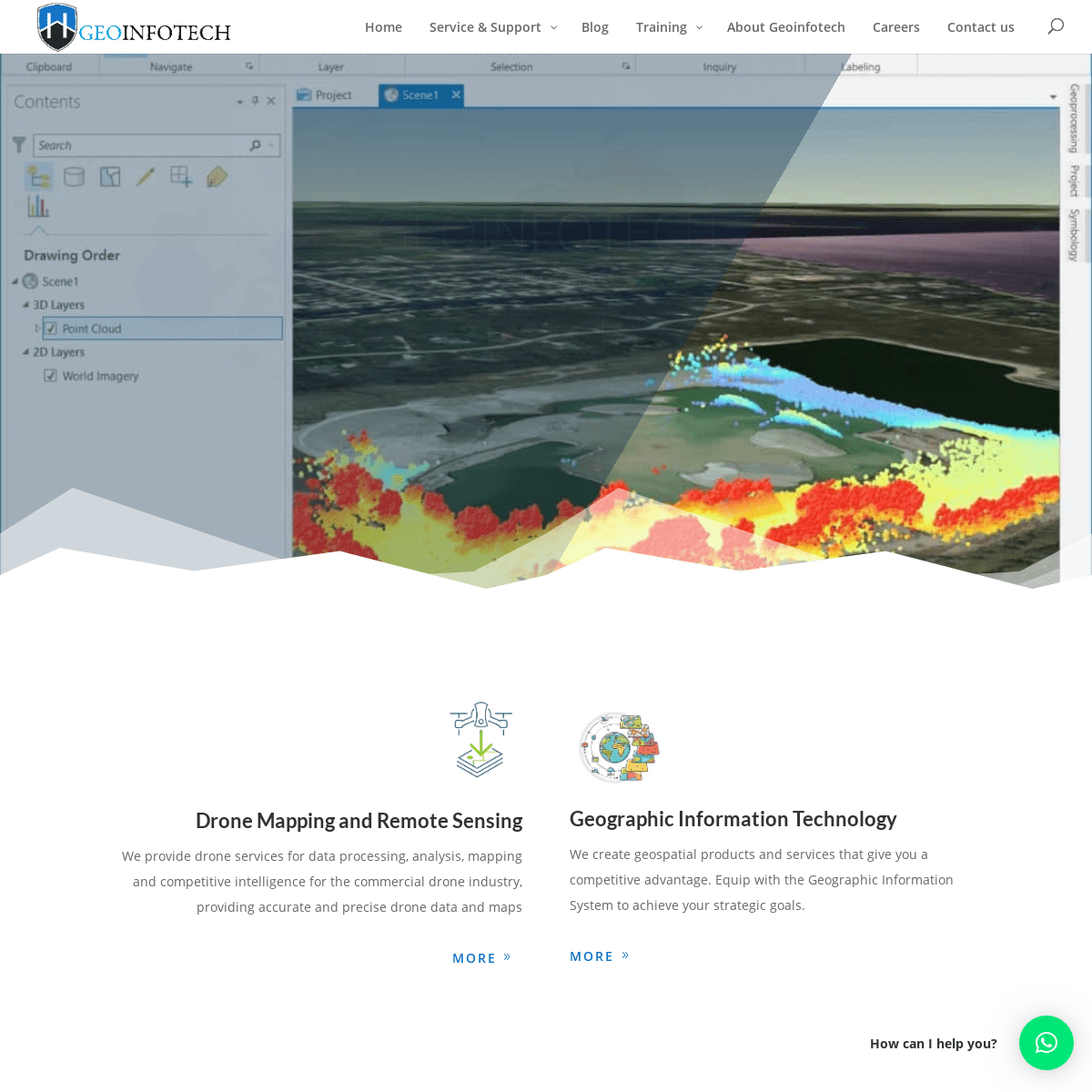
DRONE MAPPING AND REMOTE SENSING We provide drone services for data processing, analysis, mapping and competitive intelligence for the commercial drone industry, providing accurate and precise drone data and mapsMore
GEOGRAPHIC INFORMATION TECHNOLOGY We create geospatial products and services that give you a competitive advantage. Equip with the Geographic Information System to achieve your strategic goals.More
DIGITAL SURFACE AND TERRAIN MODELS (DSM, DTM) We create maps and Apps through robust Geographic Information Systems (GIS) empowering us to manage and process spatial datawith the
application of location-based services, 3D Geospatial support services and mapping solutions. GEOGRAPHIC INFORMATION SYSTEM * Geo-Spatial Analysis * Web Mapping and Application * Cartographic Mapping* Data Sales
* Training
* More…
REMOTE SENSING
* Satellite Image Processing * High Resolution Satellite Image Sales/Download * Image Analysis of Digital Surface and Terrain Models (DSM, DTM) with precisions far higher than any other product.* Training
* More…
Learn More
HIGH PRECISION\u00a0DRONE IMAGES\n Drone Mapping, Creating 3D models from 2D aerial photos.\u00a0Drone-based aerial photograph to smart design of competitive modelling\n\n SATELLITE IMAGE PROCESSING\NPRECISE EARTH OBSERVATION TECHNOLOGIES, WE GATHER DATA WITH DISTINCTIVE PROPERTIES, SO LARGE AND COMPLEX. OFTEN DELIVER MULTI-SOURCE \/ MULTI-TEMPORAL \/ MULTI-SCALE INFORMATION.\N","TABLET":"","PHONE":"HIGH PRECISION PROCESSING OF DRONE DATA\N\NDRONE MAPPING PHOTOGRAMMETRY CREATING 3D MODELS FROM 2D AERIAL PHOTOS. DRONE-BASED AERIAL PHOTOGRAPH TO THE SMART DESIGN OF COMPETITIVE MODELING; WE BRING ART AND SCIENCE TOGETHER TO BUILD A CULTURE OF CREATIVE ENTREPRENEURSHIP AND TECHNOLOGY AT GEOINFOTECH\N"}},"SLUG":"ET_PB_TEXT"}" DATA-ET-MULTI-VIEW-LOAD-TABLET-HIDDEN="TRUE" DATA-ET-MULTI-VIEW-LOAD-PHONE-HIDDEN="TRUE">HIGH PRECISION DRONE IMAGES Drone Mapping, Creating 3D models from 2D aerial photos. Drone-based aerial photograph to smart design of competitive modellingSATELLITE IMAGE
PROCESSING
Precise Earth observation technologies, we gather data with distinctive properties, so large and complex. Often deliver multi-source / multi-temporal / multi-scale information.DRONE MAPPING
* Flying and Renting of Drones * Aerial Photographs * Drone Mapping Photogrammetry * Creating 3D models from 2D aerial photos * Video Clips Live Broadcasts* Drone Training
* 360° Panoramas Post-flight splicing and loading to platforms * Image & Video Post-Processing * Drone Acquisition Platform-agnostic fleet advice * Corporate Drone Consulting* More…
Learn More
ADVANCE GIS <> GPS PRECISION AND ANALYTICS We believe in the power of maps to enrich, challenge, and expand our understanding of Earth systems. BASIC – ADVANCE TRAINING CLASSES AVAILABLE: Schedule a training with one of our Experts. Our dedicated training suite is designed for variety of public courses to ensure effective, hands-on training. We can tailor courses specifically to your Industry needs.Start Training
PREVIOUS PROJECTS & ACTIVITIES Geoinfotech has also been at the frontier of several GIS, Drone and Remote sensing based projects* All
* Drone
* GIS and Remote sensing * Training and Workshop* Website
BENUE FLOOD ANALYSIS Drone , GIS and Remotesensing
AERIAL PHOTOGRAPHY ILE-IFE OSUN STATE Drone , GIS and Remotesensing
KENYA FOREST PROJECT Drone , GIS and Remotesensing
TUNSUN CONSULTANTS LTDWebsite
INTRODUCTION TO GIS IN MARITIME AT THE NATIONAL BOUNDARY COMMISSION GIS and Remote sensing , Training and Workshop TRAINING ON GIS AND DRONE MAPPING (BATCH-4 & 5) Drone , GIS and Remote sensing , Training andWorkshop
OSUN FLOOD MAPPING
Drone , GIS and Remotesensing
LAHASS INTERNATIONAL LIMITEDWebsite
LINGUISTIC ASSOCIATION OF NIGERIAWebsite
WEST AFRICAN INDEXING SERVICESWebsite
LAGOS, IKEJA ROAD NETWORK MAP Drone , GIS and Remotesensing
LINGUA PLUS INTERNATIONALWebsite
* Prev
* 1
* 2
* 3
* Next
START A PROJECT WITH US We are passionate about proffering the best of service you needGEOSPATIAL SERVICES
We render geospatial services, GIS, Remote Sensing, Web Development and Drone services for data processing, analysis, mapping and competitive intelligence that give you a competitive advantage. Get Started / Hire usNEED A FREELANCER
Do you need a team for your project to create products and services by applying Geospatial technology to give you the competitive advantageRequest a Freelance
WHAT OUR CLIENTS SAY We’re very passionate about our clients, the products we reel out and the services we render, as you can always count on us 24/7. div.slide" data-cycletwo-log="false" style="position: relative;overflow: hidden;">
__ __ __ __ __
MR BANJI AGBO
OAU SENIOR LEC FACULTY OF AGRIC, GIS AND REMOTE SENSING, Geo - infotech company has really been of great help to remodel my carrier path in Agriculture. I had been aspiring to explore the use of GIS and Remote Sensing in Weed Management for a very long time. Thinking such innovative ideas may be unrealistic in Nigeria has always been a concern until I came across Geo - infotech. Doing such practical training exposed me to the world of X -Y- Z coordinate system, mapping, image analysis, use of phyton, etc. Their tutors are very sound. They don't just train you to get certified. There training gave me insight into what my Ph.D. studies are focusing on at the moment.Geoinfotech
5
2020-03-25T00:26:29+00:00 OAU SENIOR LEC FACULTY OF AGRIC, GIS AND REMOTE SENSING, Geo - infotech company has really been of great help to remodel my carrier path in Agriculture. I had been aspiring to explore the use of GIS and Remote Sensing in Weed Management for a very long time. Thinking such innovative ideas may be unrealistic in Nigeria has always been a concern until I came across Geo - infotech. Doing such practical training exposed me to the world of X -Y- Z coordinate system, mapping, image analysis, use of phyton, etc. Their tutors are very sound. They don't just train you to get certified. There training gave me insight into what my Ph.D. studies are focusing on at the moment. https://geoinfotech.ng/testimonials/mr-banji-agbo/__ __ __ __ __
ANUOLUWAPO OPATOYE
NATIONAL BOUNDARY COMMISSION, PROGRAM: GIS IN MARITIME It's being educative.Geoinfotech
5
2020-03-25T04:49:31+00:00 NATIONAL BOUNDARY COMMISSION, PROGRAM: GIS IN MARITIME It's being educative. https://geoinfotech.ng/testimonials/anuoluwapo-opatoye/__ __ __ __ __
MEZUE EMMANUEL CHEKWUBE MSC ARCSST OAU, INTRODUCTION TO GIS, It was a great privilege training under Geoinfotech, their competent teachers made the training easy and fun and with level one GIS Training I can confidently carry out essential GIS Analysis. I am satisfied with your training and I also wish to continue on an Advanceclass
Geoinfotech
5
2020-03-25T00:58:22+00:00 MSC ARCSST OAU, INTRODUCTION TO GIS, It was a great privilege training under Geoinfotech, their competent teachers made the training easy and fun and with level one GIS Training I can confidently carry out essential GIS Analysis. I am satisfied with your training and I also wish to continue on an Advanceclass
It was a great privilege training under Geoinfotech, their competent teachers made the training easy and fun and with level one GIS Training I can confidently carry out essential GIS Analysis. I am satisfied with your training and I also wish to continue on an Advanceclass
https://geoinfotech.ng/testimonials/mezue-emmanuel-chekwube/5
9
Geoinfotech
__ __ __ __ __
MR CHIBUEZE NWAKA
Environmentalist, Introduction to GIS,I want to thank everybody, I want to thank Mr. Yinka and Mr. Tope, they seem to understand to have been lenient to us, any time I call Mr. Tope or send a message he is always available. The only thing I want us to correct is about time, but every other thing has been fantasticGeoinfotech
5
2020-03-25T03:52:52+00:00 Environmentalist, Introduction to GIS,I want to thank everybody, I want to thank Mr. Yinka and Mr. Tope, they seem to understand to have been lenient to us, any time I call Mr. Tope or send a message he is always available. The only thing I want us to correct is about time, but every other thing has been fantastic https://geoinfotech.ng/testimonials/mr-chibueze-nwaka/__ __ __ __ __
GODWIN DIMIKE
GEOLOGIST, NATIONAL BOUNDARY COMMISSION, PROGRAM: GIS IN MARITIME The training has been very informative, the tutors took the time to explain especially more difficult tasks, it has been very enjoyable so far. training period should be extended to make us more familiar with the program. There is a need to go further with more advanced aspectsof the program.
The tutors are well-grounded on the program they have been really patient and listens to everyone's opinionsGeoinfotech
5
2020-03-25T04:58:02+00:00 GEOLOGIST, NATIONAL BOUNDARY COMMISSION, PROGRAM: GIS IN MARITIME The training has been very informative, the tutors took the time to explain especially more difficult tasks, it has been very enjoyable so far. training period should be extended to make us more familiar with the program. There is a need to go further with more advanced aspectsof the program.
The tutors are well-grounded on the program they have been really patient and listens to everyone's opinions https://geoinfotech.ng/testimonials/godwindimike/__ __ __ __ __
ABBA ISMAIL
COMPUTER ANALYST, National Boundary Commission, Program: GIS inMaritime
The training is very interesting and educative, it helps to understand how ArcGIS work on the real-world map. The trainers are very good teachers, they help me understand what ArcGIS MeansGeoinfotech
5
2020-03-25T04:53:00+00:00 COMPUTER ANALYST, National Boundary Commission, Program: GIS inMaritime
The training is very interesting and educative, it helps to understand how ArcGIS work on the real-world map. The trainers are very good teachers, they help me understand what ArcGIS Means https://geoinfotech.ng/testimonials/abba-ismail/__ __ __ __ __
MR BANJI AGBO
OAU SENIOR LEC FACULTY OF AGRIC, GIS AND REMOTE SENSING, Geo - infotech company has really been of great help to remodel my carrier path in Agriculture. I had been aspiring to explore the use of GIS and Remote Sensing in Weed Management for a very long time. Thinking such innovative ideas may be unrealistic in Nigeria has always been a concern until I came across Geo - infotech. Doing such practical training exposed me to the world of X -Y- Z coordinate system, mapping, image analysis, use of phyton, etc. Their tutors are very sound. They don't just train you to get certified. There training gave me insight into what my Ph.D. studies are focusing on at the moment.Geoinfotech
5
2020-03-25T00:26:29+00:00 OAU SENIOR LEC FACULTY OF AGRIC, GIS AND REMOTE SENSING, Geo - infotech company has really been of great help to remodel my carrier path in Agriculture. I had been aspiring to explore the use of GIS and Remote Sensing in Weed Management for a very long time. Thinking such innovative ideas may be unrealistic in Nigeria has always been a concern until I came across Geo - infotech. Doing such practical training exposed me to the world of X -Y- Z coordinate system, mapping, image analysis, use of phyton, etc. Their tutors are very sound. They don't just train you to get certified. There training gave me insight into what my Ph.D. studies are focusing on at the moment. https://geoinfotech.ng/testimonials/mr-banji-agbo/__ __ __ __ __
ANUOLUWAPO OPATOYE
NATIONAL BOUNDARY COMMISSION, PROGRAM: GIS IN MARITIME It's being educative.Geoinfotech
5
2020-03-25T04:49:31+00:00 NATIONAL BOUNDARY COMMISSION, PROGRAM: GIS IN MARITIME It's being educative. https://geoinfotech.ng/testimonials/anuoluwapo-opatoye/__ __ __ __ __
MEZUE EMMANUEL CHEKWUBE MSC ARCSST OAU, INTRODUCTION TO GIS, It was a great privilege training under Geoinfotech, their competent teachers made the training easy and fun and with level one GIS Training I can confidently carry out essential GIS Analysis. I am satisfied with your training and I also wish to continue on an Advanceclass
Geoinfotech
5
2020-03-25T00:58:22+00:00 MSC ARCSST OAU, INTRODUCTION TO GIS, It was a great privilege training under Geoinfotech, their competent teachers made the training easy and fun and with level one GIS Training I can confidently carry out essential GIS Analysis. I am satisfied with your training and I also wish to continue on an Advanceclass
It was a great privilege training under Geoinfotech, their competent teachers made the training easy and fun and with level one GIS Training I can confidently carry out essential GIS Analysis. I am satisfied with your training and I also wish to continue on an Advanceclass
https://geoinfotech.ng/testimonials/mezue-emmanuel-chekwube/__ __ __ __ __
MR OKUNOLA ORIOLA
BSC LASU LAGOS STATE, INTRODUCTION TO GIS, First of all, I want to thank all the team at Geoinfotech for the opportunity they have given us, I want to say this is not the endGeoinfotech
5
2020-03-25T01:08:53+00:00 BSC LASU LAGOS STATE, INTRODUCTION TO GIS, First of all, I want to thank all the team at Geoinfotech for the opportunity they have given us, I want to say this is not the end https://geoinfotech.ng/testimonials/mr-okunola-oriola/__ __ __ __ __
JOY ETIM
NATIONAL BOUNDARY COMMISSION, PROGRAM: GIS IN MARITIME The training is very impactful, interactive, informative and educative. Would appreciate and recommend more of this training in the very near future. The lecturers are very friendly and understanding which makes the training lively, interesting and simplified. More grease to your elbow keep up the good work. Kudos.Geoinfotech
5
2020-03-25T04:45:45+00:00 NATIONAL BOUNDARY COMMISSION, PROGRAM: GIS IN MARITIME The training is very impactful, interactive, informative and educative. Would appreciate and recommend more of this training in the very near future. The lecturers are very friendly and understanding which makes the training lively, interesting and simplified. More grease to your elbow keep up the good work. Kudos. https://geoinfotech.ng/testimonials/joy-etim/__ __ __ __ __
OSUNDE O.M.MSC
OAU SENIOR LEC FACULTY OF AGRIC, TRAINING IN GIS AND REMOTE SENSING Geoinfotech is a spatial academic center where the interest of the students is a priority. The commitment of the tutors is unwavering irrespective of the student’s financial commitment. Having gone through the rudimentary training in spatial technology, I recommend the geoinfotech center for the real seekers of spatial knowledge.Geoinfotech
5
2020-03-25T00:45:40+00:00 OAU SENIOR LEC FACULTY OF AGRIC, TRAINING IN GIS AND REMOTE SENSING Geoinfotech is a spatial academic center where the interest of the students is a priority. The commitment of the tutors is unwavering irrespective of the student’s financial commitment. Having gone through the rudimentary training in spatial technology, I recommend the geoinfotech center for the real seekers of spatial knowledge. https://geoinfotech.ng/testimonials/osunde-o-m-msc/__
__
div.slide" data-cycletwo-log="false" style="position: relative;overflow: hidden;">
GODWIN DIMIKE
__________
GEOLOGIST, NATIONAL BOUNDARY COMMISSION, PROGRAM: GIS IN MARITIME The training has been very informative, the tutors took the time to explain especially more difficult tasks, it has been very enjoyable so far. training period should be extended to make us more familiar with the program. There is a need to go further with more advanced aspectsof the program.
The tutors are well-grounded on the program they have been really patient and listens to everyone's opinionsGeoinfotech
5
2020-03-25T04:58:02+00:00 GEOLOGIST, NATIONAL BOUNDARY COMMISSION, PROGRAM: GIS IN MARITIME The training has been very informative, the tutors took the time to explain especially more difficult tasks, it has been very enjoyable so far. training period should be extended to make us more familiar with the program. There is a need to go further with more advanced aspectsof the program.
The tutors are well-grounded on the program they have been really patient and listens to everyone's opinions https://geoinfotech.ng/testimonials/godwindimike/5
9
Geoinfotech
GODWIN DIMIKE
__________
GEOLOGIST, NATIONAL BOUNDARY COMMISSION, PROGRAM: GIS IN MARITIME The training has been very informative, the tutors took the time to explain especially more difficult tasks, it has been very enjoyable so far. training period should be extended to make us more familiar with the program. There is a need to go further with more advanced aspectsof the program.
The tutors are well-grounded on the program they have been really patient and listens to everyone's opinionsGeoinfotech
5
2020-03-25T04:58:02+00:00 GEOLOGIST, NATIONAL BOUNDARY COMMISSION, PROGRAM: GIS IN MARITIME The training has been very informative, the tutors took the time to explain especially more difficult tasks, it has been very enjoyable so far. training period should be extended to make us more familiar with the program. There is a need to go further with more advanced aspectsof the program.
The tutors are well-grounded on the program they have been really patient and listens to everyone's opinions https://geoinfotech.ng/testimonials/godwindimike/OSUNDE O.M.MSC
__________
OAU SENIOR LEC FACULTY OF AGRIC, TRAINING IN GIS AND REMOTE SENSING Geoinfotech is a spatial academic center where the interest of the students is a priority. The commitment of the tutors is unwavering irrespective of the student’s financial commitment. Having gone through the rudimentary training in spatial technology, I recommend the geoinfotech center for the real seekers of spatial knowledge.Geoinfotech
5
2020-03-25T00:45:40+00:00 OAU SENIOR LEC FACULTY OF AGRIC, TRAINING IN GIS AND REMOTE SENSING Geoinfotech is a spatial academic center where the interest of the students is a priority. The commitment of the tutors is unwavering irrespective of the student’s financial commitment. Having gone through the rudimentary training in spatial technology, I recommend the geoinfotech center for the real seekers of spatial knowledge. https://geoinfotech.ng/testimonials/osunde-o-m-msc/ANUOLUWAPO OPATOYE
__________
NATIONAL BOUNDARY COMMISSION, PROGRAM: GIS IN MARITIME It's being educative.Geoinfotech
5
2020-03-25T04:49:31+00:00 NATIONAL BOUNDARY COMMISSION, PROGRAM: GIS IN MARITIME It's being educative. https://geoinfotech.ng/testimonials/anuoluwapo-opatoye/MR BANJI AGBO
__________
OAU SENIOR LEC FACULTY OF AGRIC, GIS AND REMOTE SENSING, Geo - infotech company has really been of great help to remodel my carrier path in Agriculture. I had been aspiring to explore the use of GIS and Remote Sensing in Weed Management for a very long time. Thinking such innovative ideas may be unrealistic in Nigeria has always been a concern until I came across Geo - infotech. Doing such practical training exposed me to the world of X -Y- Z coordinate system, mapping, image analysis, use of phyton, etc. Their tutors are very sound. They don't just train you to get certified. There training gave me insight into what my Ph.D. studies are focusing on at the moment.Geoinfotech
5
2020-03-25T00:26:29+00:00 OAU SENIOR LEC FACULTY OF AGRIC, GIS AND REMOTE SENSING, Geo - infotech company has really been of great help to remodel my carrier path in Agriculture. I had been aspiring to explore the use of GIS and Remote Sensing in Weed Management for a very long time. Thinking such innovative ideas may be unrealistic in Nigeria has always been a concern until I came across Geo - infotech. Doing such practical training exposed me to the world of X -Y- Z coordinate system, mapping, image analysis, use of phyton, etc. Their tutors are very sound. They don't just train you to get certified. There training gave me insight into what my Ph.D. studies are focusing on at the moment. https://geoinfotech.ng/testimonials/mr-banji-agbo/ABBA ISMAIL
__________
COMPUTER ANALYST, National Boundary Commission, Program: GIS inMaritime
The training is very interesting and educative, it helps to understand how ArcGIS work on the real-world map. The trainers are very good teachers, they help me understand what ArcGIS MeansGeoinfotech
5
2020-03-25T04:53:00+00:00 COMPUTER ANALYST, National Boundary Commission, Program: GIS inMaritime
The training is very interesting and educative, it helps to understand how ArcGIS work on the real-world map. The trainers are very good teachers, they help me understand what ArcGIS Means https://geoinfotech.ng/testimonials/abba-ismail/MR OKUNOLA ORIOLA
__________
BSC LASU LAGOS STATE, INTRODUCTION TO GIS, First of all, I want to thank all the team at Geoinfotech for the opportunity they have given us, I want to say this is not the endGeoinfotech
5
2020-03-25T01:08:53+00:00 BSC LASU LAGOS STATE, INTRODUCTION TO GIS, First of all, I want to thank all the team at Geoinfotech for the opportunity they have given us, I want to say this is not the end https://geoinfotech.ng/testimonials/mr-okunola-oriola/MR CHIBUEZE NWAKA
__________
Environmentalist, Introduction to GIS,I want to thank everybody, I want to thank Mr. Yinka and Mr. Tope, they seem to understand to have been lenient to us, any time I call Mr. Tope or send a message he is always available. The only thing I want us to correct is about time, but every other thing has been fantasticGeoinfotech
5
2020-03-25T03:52:52+00:00 Environmentalist, Introduction to GIS,I want to thank everybody, I want to thank Mr. Yinka and Mr. Tope, they seem to understand to have been lenient to us, any time I call Mr. Tope or send a message he is always available. The only thing I want us to correct is about time, but every other thing has been fantastic https://geoinfotech.ng/testimonials/mr-chibueze-nwaka/ MEZUE EMMANUEL CHEKWUBE__________
MSC ARCSST OAU, INTRODUCTION TO GIS, It was a great privilege training under Geoinfotech, their competent teachers made the training easy and fun and with level one GIS Training I can confidently carry out essential GIS Analysis. I am satisfied with your training and I also wish to continue on an Advanceclass
Geoinfotech
5
2020-03-25T00:58:22+00:00 MSC ARCSST OAU, INTRODUCTION TO GIS, It was a great privilege training under Geoinfotech, their competent teachers made the training easy and fun and with level one GIS Training I can confidently carry out essential GIS Analysis. I am satisfied with your training and I also wish to continue on an Advanceclass
It was a great privilege training under Geoinfotech, their competent teachers made the training easy and fun and with level one GIS Training I can confidently carry out essential GIS Analysis. I am satisfied with your training and I also wish to continue on an Advanceclass
https://geoinfotech.ng/testimonials/mezue-emmanuel-chekwube/JOY ETIM
__________
NATIONAL BOUNDARY COMMISSION, PROGRAM: GIS IN MARITIME The training is very impactful, interactive, informative and educative. Would appreciate and recommend more of this training in the very near future. The lecturers are very friendly and understanding which makes the training lively, interesting and simplified. More grease to your elbow keep up the good work. Kudos.Geoinfotech
5
2020-03-25T04:45:45+00:00 NATIONAL BOUNDARY COMMISSION, PROGRAM: GIS IN MARITIME The training is very impactful, interactive, informative and educative. Would appreciate and recommend more of this training in the very near future. The lecturers are very friendly and understanding which makes the training lively, interesting and simplified. More grease to your elbow keep up the good work. Kudos. https://geoinfotech.ng/testimonials/joy-etim/__
__
Read All Reviews
* Flying and Renting of Drones * Aerial Photographs * Drone Mapping Photogrammetry Creating 3D models from 2D aerialphotos.
* Video Clips Live Broadcasts* Drone Training
* 360° Panoramas Post-flight splicing and loading to platforms * Image & Video Post-Processing * Drone Acquisition Platform-agnostic fleet advice * Corporate Drone Consulting including ‘Management By Flying Around, legal industrial espionage, industry-specific drone businessopportunities.
WHAT'S NEW
BLOG / NEWS
ONDO – AKURE EXPLOSION ALONG OWO ROADMar 28, 2020
The explosion shook Akure overnight, demolished houses including church, building, Ogbese fuel...CORONA VIRUS 2019
Mar 27, 2020
Check out the LIVE WEB MAP on Corona Virus Global Cases by JohnsHopkins CSSE...
IBEJU LEKKI, LAGOS STATE LANDUSE / LANDCOVER DYNAMICSMar 10, 2020
IBEJU LEKKI Local Government Area is situated between longitudes 3o44'0" and 4o10'0"N and...� Older Entries
CONTEXT TO 3DS MAX MODELS WITH THE CESIUM ION PLUGINJan 8, 2020
Whether you’re sketching out plans for a new highway or designing the smart cities of the future,... WEB APPBUILDER FOR ARCGIS 2.14 DEVELOPER EDITION NOW ACCESSIBLE!Oct 30, 2019
Form 2.14 of Web AppBuilder for ArcGIS Developer Edition has quite recently been discharged and is... THE ARCGIS SERVER SECURITY 2019 UPDATE 2 PATCH IS NOW AVAILABLE!Oct 30, 2019
The ArcGIS Server Security 2019 Update 2 Patch is presently live on the support page site. The URL...� Older Entries
GIS
THINK SPATIAL OF GROWING YOUR BUSINESS TECHNOLOGY THAT ALLOWS YOU MAKE BETTER DECISIONS. START A PROJECT WITH US TODAYStart a Project
NEW DISCOUNT TRAINING OFFER!! The new advance practical and Field Training offers free software’sand GIS data
We offer training in Lagos, Abuja, and Osun State in Nigeria Register now ₦48,900 - GIS Register now ₦85,900 - DroneJOIN OUR NEWSLETTER
Be among to know whats happening, get free updates and amazing services from Geoinfotech HI DEAR, WE'VE ADDED YOU TO OUR EMAIL LIST. YOU'LL GET A MAIL FROM USSHORTLY.
Name
Subscribe
Technology Everywheremail@geoinfotech.ng
+234 816 322 2177
+234 901 872 4833
SUPPORT / SERVICE
Training
Training RegistrationNEED HELP
Help Center
About Geoinfotech
Contact us
Hire us
Need a Freelancer
SERVICES
Drone Pilot and Mapping GIS & Remote SensingQUICK LINK
About
Service
Search
Training programs
Blog
Recent Update
Customer Service
Project
RECENT POSTS
FOLLOW US
* Follow
* Follow
* Follow
* Follow
HI DEAR, WE'VE ADDED YOU TO OUR EMAIL LIST. YOU'LL GET A MAIL FROM USSHORTLY.
Name
Subscribe
Click Here to Subscribe � 2020 Geoinfotech Enterprises. All rights reserved_×_
HELLO! GEOINFOTECH
Click below to chat on WhatsApp or send us an email toMAIL@GEOINFOTECH.NG
Support | Click here to Chat with us Joseph � 2020 All rights reserved Geoinfotech __ _×_ How can I help you?Details
3