4
More Annotations


3


4
Favourite Annotations


5


6
Text
FLOOD WARNINGS FOR ENGLAND View the latest river and sea levels near you. Check the long term flood risk for an area in England. View the 5-day flood risk. Sign up for flood warnings. Other ways to get flood warning information. For current flood warnings in force please call our 24-hour Floodline on: Telephone: 0345 988 1188. Type talk: 0345 602 6340 (for the hard of CHECK THE LONG TERM FLOOD RISK FOR AN AREA IN ENGLAND This service uses computer models to assess an area’s long term risk from: rivers and the sea. surface water. reservoirs. some groundwater. The results are an indicator of an area’s flood risk, particularly the likelihood of surface water flooding. It is not suitable for identifying whether an RIVER AND SEA LEVELS IN ENGLAND River and sea levels in England. 8:15am Monday 17 May 2021. River and sea levels are regularly checked by this network of monitoring stations. These levels can help you understand your flood risk now and in the next few days. Enter a postcode or place to get information from your nearest stations. FLOOD WARNINGS FOR CHESTER, CHESHIRE WEST AND View the 5-day flood risk. Sign up for flood warnings. Other ways to get flood warning information. For current flood warnings in force please call our 24-hour Floodline on: Telephone: 0345 988 1188. Type talk: 0345 602 6340 (for the hard of hearing) Find out more about call
charges.
RIVER AND SEA LEVELS FOR RINGWOOD, HAMPSHIRE, ENGLAND River and sea levels for: Ringwood, Hampshire, England. 4:06am Wednesday 2 June 2021. River and sea levels are regularly checked by a network of monitoring stations. These levels can help you understand your flood risk now and in the next few days. Enter a postcode or place to find your nearest station. RIVER LEVEL INFORMATION FOR MARCHINGTON BROOK AT River level Marchington Brook at Marchington Check for flood warnings in this area. Latest recorded level 0.16m at 2:45am Monday 7 June2021.
RIVER LEVEL INFORMATION FOR RIVER THAMES AT WHITCHURCH River level River Thames at Whitchurch Lock (upstream data) Check for flood warnings in this area. Latest recorded level 0.11m at 1:45am Wednesday 9 June 2021. RIVER LEVEL INFORMATION FOR RIVER COQUET AT ROTHBURY 0.333. Forecasts contain uncertainty and can change frequently. For the latest information, always check for up to date flood warnings and alerts in your area. Key information. Station name: Rothbury. Station ID: 8173. River name: River Coquet. Typical range: 0.26m to 1.80m. Highest level on record: 4.05m on 06 September 2008. RIVER LEVEL INFORMATION FOR RIVER LUNE AT CATON River level River Lune at Caton Check for flood warnings in this area. Latest recorded level 0.38m at 7:00pm Monday 7 June 2021. RIVER LEVEL INFORMATION FOR RIVER LEVEN AT FOXTON BRIDGE River level River Leven at Foxton Bridge Check for flood warnings in this area. Latest recorded level 0.22m at 6:45am Saturday 5 June 2021. FLOOD WARNINGS FOR ENGLAND View the latest river and sea levels near you. Check the long term flood risk for an area in England. View the 5-day flood risk. Sign up for flood warnings. Other ways to get flood warning information. For current flood warnings in force please call our 24-hour Floodline on: Telephone: 0345 988 1188. Type talk: 0345 602 6340 (for the hard of CHECK THE LONG TERM FLOOD RISK FOR AN AREA IN ENGLAND This service uses computer models to assess an area’s long term risk from: rivers and the sea. surface water. reservoirs. some groundwater. The results are an indicator of an area’s flood risk, particularly the likelihood of surface water flooding. It is not suitable for identifying whether an RIVER AND SEA LEVELS IN ENGLAND River and sea levels in England. 8:15am Monday 17 May 2021. River and sea levels are regularly checked by this network of monitoring stations. These levels can help you understand your flood risk now and in the next few days. Enter a postcode or place to get information from your nearest stations. FLOOD WARNINGS FOR CHESTER, CHESHIRE WEST AND View the 5-day flood risk. Sign up for flood warnings. Other ways to get flood warning information. For current flood warnings in force please call our 24-hour Floodline on: Telephone: 0345 988 1188. Type talk: 0345 602 6340 (for the hard of hearing) Find out more about callcharges.
RIVER AND SEA LEVELS FOR RINGWOOD, HAMPSHIRE, ENGLAND River and sea levels for: Ringwood, Hampshire, England. 4:06am Wednesday 2 June 2021. River and sea levels are regularly checked by a network of monitoring stations. These levels can help you understand your flood risk now and in the next few days. Enter a postcode or place to find your nearest station. RIVER LEVEL INFORMATION FOR MARCHINGTON BROOK AT River level Marchington Brook at Marchington Check for flood warnings in this area. Latest recorded level 0.16m at 2:45am Monday 7 June2021.
RIVER LEVEL INFORMATION FOR RIVER THAMES AT WHITCHURCH River level River Thames at Whitchurch Lock (upstream data) Check for flood warnings in this area. Latest recorded level 0.11m at 1:45am Wednesday 9 June 2021. RIVER LEVEL INFORMATION FOR RIVER COQUET AT ROTHBURY 0.333. Forecasts contain uncertainty and can change frequently. For the latest information, always check for up to date flood warnings and alerts in your area. Key information. Station name: Rothbury. Station ID: 8173. River name: River Coquet. Typical range: 0.26m to 1.80m. Highest level on record: 4.05m on 06 September 2008. RIVER LEVEL INFORMATION FOR RIVER LUNE AT CATON River level River Lune at Caton Check for flood warnings in this area. Latest recorded level 0.38m at 7:00pm Monday 7 June 2021. RIVER LEVEL INFORMATION FOR RIVER LEVEN AT FOXTON BRIDGE River level River Leven at Foxton Bridge Check for flood warnings in this area. Latest recorded level 0.22m at 6:45am Saturday 5 June 2021. RIVER AND SEA LEVELS IN ENGLAND River and sea levels in England. 8:15am Monday 17 May 2021. River and sea levels are regularly checked by this network of monitoring stations. These levels can help you understand your flood risk now and in the next few days. Enter a postcode or place to get information from your nearest stations. RIVER AND SEA LEVELS FOR SALE, GREATER MANCHESTER, ENGLAND River and sea levels for: Sale, Greater Manchester, England 6:59am Friday 11 June 2021. River and sea levels are regularly checked by a network of monitoring stations. RIVER LEVEL INFORMATION FOR RIVER TRENT AT DRAKELOW 1.321. Forecasts contain uncertainty and can change frequently. For the latest information, always check for up to date flood warnings and alerts in your area. Key information. Station name: Drakelow. Station ID: 2108. River name: River Trent. Typical range: 1.02m to 2.04m.Highest level on
RIVER LEVEL INFORMATION FOR RIVER MERSEY AT River level River Mersey at Northenden Check for flood warnings in this area. Latest recorded level 0.35m at 5:30am Monday 7 June 2021. RIVER LEVEL INFORMATION FOR RIVER HODDER AT HODDER PLACE River level River Hodder at Hodder Place Check for flood warnings in this area. Latest recorded level 0.33m at 3:15pm Tuesday 8 June 2021. RIVER LEVEL INFORMATION FOR RIVER ONNY AT ONIBURY River level River Onny at Onibury Check for flood warnings in this area. Latest recorded level 0.97m at 2:15pm Sunday 6 June 2021. RIVER LEVEL INFORMATION FOR RIVER AIRE AT COTTINGLEY River level River Aire at Cottingley Bridge Check for flood warnings in this area. Latest recorded level 0.41m at 7:30am Wednesday 9 June2021.
FLOOD WARNINGS FOR BURTON UPON TRENT, STAFFORDSHIRE View the 5-day flood risk. Sign up for flood warnings. Other ways to get flood warning information. For current flood warnings in force please call our 24-hour Floodline on: Telephone: 0345 988 1188. Type talk: 0345 602 6340 (for the hard of hearing) Find out more about callcharges.
RIVER LEVEL INFORMATION FOR RIVER CALDER AT ELLAND River level River Calder at Elland Check for flood warnings in this area. Latest recorded level 0.45m at 1:30am Wednesday 9 June 2021. RIVER LEVEL INFORMATION FOR RIVER OUSE AT VIKING RECORDER 0.182. Forecasts contain uncertainty and can change frequently. For the latest information, always check for up to date flood warnings and alerts in your area. Key information. Station name: Viking Recorder. Station ID: 8208. River name: River Ouse. Typical range: 0.05m to 1.90m. Highest level on record: 5.40m on 04 November 2000. FLOOD WARNINGS FOR ENGLAND For current flood warnings in force please call our 24-hour Floodline on: Telephone: 0345 988 1188 Type talk: 0345 602 6340 (for the hard ofhearing)
CHECK THE LONG TERM FLOOD RISK FOR AN AREA IN ENGLAND This service uses computer models to assess an area’s long term risk from: rivers and the sea. surface water. reservoirs. some groundwater. The results are an indicator of an area’s flood risk, particularly the likelihood of surface water flooding. It is not suitable for identifying whether an RIVER AND SEA LEVELS IN ENGLAND River and sea levels in England. 8:15am Monday 17 May 2021. River and sea levels are regularly checked by this network of monitoring stations. These levels can help you understand your flood risk now and in the next few days. Enter a postcode or place to get information from your nearest stations. FLOOD WARNINGS FOR CHESTER, CHESHIRE WEST AND View the 5-day flood risk. Sign up for flood warnings. Other ways to get flood warning information. For current flood warnings in force please call our 24-hour Floodline on: Telephone: 0345 988 1188. Type talk: 0345 602 6340 (for the hard of hearing) Find out more about callcharges.
RIVER LEVEL INFORMATION FOR MARCHINGTON BROOK AT River level Marchington Brook at Marchington Check for flood warnings in this area. Latest recorded level 0.16m at 2:45am Monday 7 June2021.
RIVER AND SEA LEVELS FOR RINGWOOD, HAMPSHIRE, ENGLAND River and sea levels for: Ringwood, Hampshire, England. 4:06am Wednesday 2 June 2021. River and sea levels are regularly checked by a network of monitoring stations. These levels can help you understand your flood risk now and in the next few days. Enter a postcode or place to find your nearest station. RIVER LEVEL INFORMATION FOR RIVER THAMES AT WHITCHURCH River level River Thames at Whitchurch Lock (upstream data) Check for flood warnings in this area. Latest recorded level 0.09m at 11:00pmMonday 7 June 2021.
RIVER LEVEL INFORMATION FOR RIVER COQUET AT ROTHBURY 0.333. Forecasts contain uncertainty and can change frequently. For the latest information, always check for up to date flood warnings and alerts in your area. Key information. Station name: Rothbury. Station ID: 8173. River name: River Coquet. Typical range: 0.26m to 1.80m. Highest level on record: 4.05m on 06 September 2008. RIVER LEVEL INFORMATION FOR RIVER LUNE AT CATON River level River Lune at Caton Check for flood warnings in this area. Latest recorded level 0.38m at 7:00pm Monday 7 June 2021. RIVER LEVEL INFORMATION FOR RIVER LEVEN AT FOXTON BRIDGE River level River Leven at Foxton Bridge Check for flood warnings in this area. Latest recorded level 0.22m at 6:45am Saturday 5 June 2021. FLOOD WARNINGS FOR ENGLAND For current flood warnings in force please call our 24-hour Floodline on: Telephone: 0345 988 1188 Type talk: 0345 602 6340 (for the hard ofhearing)
RIVER AND SEA LEVELS FOR HEBDEN BRIDGE, WEST YORKSHIRE River and sea levels for: Hebden Bridge, West Yorkshire, England. 10:32pm Tuesday 8 June 2021. River and sea levels are regularly checked by a network of monitoring stations. These levels can help you understand your flood risk now and in the next few days. Enter a RIVER LEVEL INFORMATION FOR RIVER MERSEY AT River level River Mersey at Northenden Check for flood warnings in this area. Latest recorded level 0.35m at 5:30am Monday 7 June 2021. RIVER LEVEL INFORMATION FOR RIVER TRENT AT DRAKELOW 1.321. Forecasts contain uncertainty and can change frequently. For the latest information, always check for up to date flood warnings and alerts in your area. Key information. Station name: Drakelow. Station ID: 2108. River name: River Trent. Typical range: 1.02m to 2.04m.Highest level on
RIVER LEVEL INFORMATION FOR RIVER EXE AT TIVERTON River level River Exe at Tiverton Check for flood warnings in this area. Latest recorded level 0.45m at 5:00pm Monday 7 June 2021. FLOOD WARNINGS FOR BURTON UPON TRENT, STAFFORDSHIRE View the 5-day flood risk. Sign up for flood warnings. Other ways to get flood warning information. For current flood warnings in force please call our 24-hour Floodline on: Telephone: 0345 988 1188. Type talk: 0345 602 6340 (for the hard of hearing) Find out more about callcharges.
RIVER LEVEL INFORMATION FOR RIVER ONNY AT ONIBURY River level River Onny at Onibury Check for flood warnings in this area. Latest recorded level 0.97m at 2:15pm Sunday 6 June 2021. RIVER LEVEL INFORMATION FOR RIVER THAMES AT IFFLEY LOCK River level River Thames at Iffley Lock (downstream data) Check for flood warnings in this area. Latest recorded level 2.27m at 3:45pm Wednesday 2 June 2021. RIVER LEVEL INFORMATION FOR RIVER SEVERN AT DIGLIS River level River Severn at Diglis Check for flood warnings in this area. Latest recorded level 0.59m at 2:45am Tuesday 8 June 2021. RIVER LEVEL INFORMATION FOR RIVER URE AT RIPON URE BANK River level River Ure at Ripon Ure Bank Check for flood warnings in this area. Latest recorded level 0.00m at 3:15pm Sunday 6 June 2021. FLOOD WARNINGS FOR ENGLAND For current flood warnings in force please call our 24-hour Floodline on: Telephone: 0345 988 1188 Type talk: 0345 602 6340 (for the hard ofhearing)
CHECK THE LONG TERM FLOOD RISK FOR AN AREA IN ENGLAND This service uses computer models to assess an area’s long term risk from: rivers and the sea. surface water. reservoirs. some groundwater. The results are an indicator of an area’s flood risk, particularly the likelihood of surface water flooding. It is not suitable for identifying whether an RIVER AND SEA LEVELS IN ENGLAND River and sea levels in England. 8:15am Monday 17 May 2021. River and sea levels are regularly checked by this network of monitoring stations. These levels can help you understand your flood risk now and in the next few days. Enter a postcode or place to get information from your nearest stations. FLOOD WARNINGS FOR CHESTER, CHESHIRE WEST AND View the 5-day flood risk. Sign up for flood warnings. Other ways to get flood warning information. For current flood warnings in force please call our 24-hour Floodline on: Telephone: 0345 988 1188. Type talk: 0345 602 6340 (for the hard of hearing) Find out more about callcharges.
RIVER LEVEL INFORMATION FOR MARCHINGTON BROOK AT River level Marchington Brook at Marchington Check for flood warnings in this area. Latest recorded level 0.16m at 2:45am Monday 7 June2021.
RIVER AND SEA LEVELS FOR RINGWOOD, HAMPSHIRE, ENGLAND River and sea levels for: Ringwood, Hampshire, England. 4:06am Wednesday 2 June 2021. River and sea levels are regularly checked by a network of monitoring stations. These levels can help you understand your flood risk now and in the next few days. Enter a postcode or place to find your nearest station. RIVER LEVEL INFORMATION FOR RIVER THAMES AT WHITCHURCH River level River Thames at Whitchurch Lock (upstream data) Check for flood warnings in this area. Latest recorded level 0.09m at 11:00pmMonday 7 June 2021.
RIVER LEVEL INFORMATION FOR RIVER COQUET AT ROTHBURY 0.333. Forecasts contain uncertainty and can change frequently. For the latest information, always check for up to date flood warnings and alerts in your area. Key information. Station name: Rothbury. Station ID: 8173. River name: River Coquet. Typical range: 0.26m to 1.80m. Highest level on record: 4.05m on 06 September 2008. RIVER LEVEL INFORMATION FOR RIVER LUNE AT CATON River level River Lune at Caton Check for flood warnings in this area. Latest recorded level 0.38m at 7:00pm Monday 7 June 2021. RIVER LEVEL INFORMATION FOR RIVER LEVEN AT FOXTON BRIDGE River level River Leven at Foxton Bridge Check for flood warnings in this area. Latest recorded level 0.22m at 6:45am Saturday 5 June 2021. FLOOD WARNINGS FOR ENGLAND For current flood warnings in force please call our 24-hour Floodline on: Telephone: 0345 988 1188 Type talk: 0345 602 6340 (for the hard ofhearing)
RIVER AND SEA LEVELS FOR HEBDEN BRIDGE, WEST YORKSHIRE River and sea levels for: Hebden Bridge, West Yorkshire, England. 10:32pm Tuesday 8 June 2021. River and sea levels are regularly checked by a network of monitoring stations. These levels can help you understand your flood risk now and in the next few days. Enter a RIVER LEVEL INFORMATION FOR RIVER MERSEY AT River level River Mersey at Northenden Check for flood warnings in this area. Latest recorded level 0.35m at 5:30am Monday 7 June 2021. RIVER LEVEL INFORMATION FOR RIVER TRENT AT DRAKELOW 1.321. Forecasts contain uncertainty and can change frequently. For the latest information, always check for up to date flood warnings and alerts in your area. Key information. Station name: Drakelow. Station ID: 2108. River name: River Trent. Typical range: 1.02m to 2.04m.Highest level on
RIVER LEVEL INFORMATION FOR RIVER EXE AT TIVERTON River level River Exe at Tiverton Check for flood warnings in this area. Latest recorded level 0.45m at 5:00pm Monday 7 June 2021. FLOOD WARNINGS FOR BURTON UPON TRENT, STAFFORDSHIRE View the 5-day flood risk. Sign up for flood warnings. Other ways to get flood warning information. For current flood warnings in force please call our 24-hour Floodline on: Telephone: 0345 988 1188. Type talk: 0345 602 6340 (for the hard of hearing) Find out more about callcharges.
RIVER LEVEL INFORMATION FOR RIVER ONNY AT ONIBURY River level River Onny at Onibury Check for flood warnings in this area. Latest recorded level 0.97m at 2:15pm Sunday 6 June 2021. RIVER LEVEL INFORMATION FOR RIVER THAMES AT IFFLEY LOCK River level River Thames at Iffley Lock (downstream data) Check for flood warnings in this area. Latest recorded level 2.27m at 3:45pm Wednesday 2 June 2021. RIVER LEVEL INFORMATION FOR RIVER SEVERN AT DIGLIS River level River Severn at Diglis Check for flood warnings in this area. Latest recorded level 0.59m at 2:45am Tuesday 8 June 2021. RIVER LEVEL INFORMATION FOR RIVER URE AT RIPON URE BANK River level River Ure at Ripon Ure Bank Check for flood warnings in this area. Latest recorded level 0.00m at 3:15pm Sunday 6 June 2021. RIVER AND SEA LEVELS IN ENGLAND River and sea levels in England. 8:15am Monday 17 May 2021. River and sea levels are regularly checked by this network of monitoring stations. These levels can help you understand your flood risk now and in the next few days. Enter a postcode or place to get information from your nearest stations. RIVER LEVEL INFORMATION FOR MARCHINGTON BROOK AT River level Marchington Brook at Marchington Check for flood warnings in this area. Latest recorded level 0.16m at 2:45am Monday 7 June2021.
RIVER LEVEL INFORMATION FOR RIVER THAMES AT WHITCHURCH River level River Thames at Whitchurch Lock (upstream data) Check for flood warnings in this area. Latest recorded level 0.08m at 4:45amSunday 6 June 2021.
RIVER LEVEL INFORMATION FOR RIVER EXE AT TIVERTON River level River Exe at Tiverton Check for flood warnings in this area. Latest recorded level 0.48m at 5:00pm Friday 4 June 2021. RIVER LEVEL INFORMATION FOR RIVER COQUET AT ROTHBURY 0.838. Forecasts contain uncertainty and can change frequently. For the latest information, always check for up to date flood warnings and alerts in your area. Key information. Station name: Rothbury. Station ID: 8173. River name: River Coquet. Typical range: 0.26m to 1.80m. Highest level on record: 4.05m on 06 September 2008. RIVER LEVEL INFORMATION FOR RIVER RODING AT LOUGHTON 0.074. Forecasts contain uncertainty and can change frequently. For the latest information, always check for up to date flood warnings and alerts in your area. Key information. Station name: Loughton. Station ID: 7380. River name: River Roding. Typical range: 0.03m to RIVER LEVEL INFORMATION FOR RIVER HODDER AT HODDER PLACE River level River Hodder at Hodder Place Check for flood warnings in this area. Latest recorded level 0.34m at 5:45pm Saturday 5 June 2021. RIVER LEVEL INFORMATION FOR CANONS BROOK AT HARLOW River level Canons Brook at Harlow, Elizabeth way Check for flood warnings in this area. Latest recorded level 0.10m at 10:00pm Saturday5 June 2021.
RIVER LEVEL INFORMATION FOR RIVER ISBOURNE AT HINTON ON River level River Isbourne at Hinton On Green Check for flood warnings in this area. Latest recorded level 0.14m at 10:45am Friday 4 June2021.
RIVER LEVEL INFORMATION FOR RIVER GREAT OUSE AT PASSENHAM River level River Great Ouse at Passenham Check for flood warnings in this area. Latest recorded level 2.08m at 6:15am Wednesday 2 June2021.
RIVER AND SEA LEVELS IN ENGLAND River and sea levels in England. 8:15am Monday 17 May 2021. River and sea levels are regularly checked by this network of monitoring stations. These levels can help you understand your flood risk now and in the next few days. Enter a postcode or place to get information from your nearest stations. RIVER LEVEL INFORMATION FOR MARCHINGTON BROOK AT River level Marchington Brook at Marchington Check for flood warnings in this area. Latest recorded level 0.16m at 2:45am Monday 7 June2021.
RIVER LEVEL INFORMATION FOR RIVER THAMES AT WHITCHURCH River level River Thames at Whitchurch Lock (upstream data) Check for flood warnings in this area. Latest recorded level 0.08m at 4:45amSunday 6 June 2021.
RIVER LEVEL INFORMATION FOR RIVER EXE AT TIVERTON River level River Exe at Tiverton Check for flood warnings in this area. Latest recorded level 0.48m at 5:00pm Friday 4 June 2021. RIVER LEVEL INFORMATION FOR RIVER COQUET AT ROTHBURY 0.838. Forecasts contain uncertainty and can change frequently. For the latest information, always check for up to date flood warnings and alerts in your area. Key information. Station name: Rothbury. Station ID: 8173. River name: River Coquet. Typical range: 0.26m to 1.80m. Highest level on record: 4.05m on 06 September 2008. RIVER LEVEL INFORMATION FOR RIVER RODING AT LOUGHTON 0.074. Forecasts contain uncertainty and can change frequently. For the latest information, always check for up to date flood warnings and alerts in your area. Key information. Station name: Loughton. Station ID: 7380. River name: River Roding. Typical range: 0.03m to RIVER LEVEL INFORMATION FOR RIVER HODDER AT HODDER PLACE River level River Hodder at Hodder Place Check for flood warnings in this area. Latest recorded level 0.34m at 5:45pm Saturday 5 June 2021. RIVER LEVEL INFORMATION FOR CANONS BROOK AT HARLOW River level Canons Brook at Harlow, Elizabeth way Check for flood warnings in this area. Latest recorded level 0.10m at 10:00pm Saturday5 June 2021.
RIVER LEVEL INFORMATION FOR RIVER ISBOURNE AT HINTON ON River level River Isbourne at Hinton On Green Check for flood warnings in this area. Latest recorded level 0.14m at 10:45am Friday 4 June2021.
RIVER LEVEL INFORMATION FOR RIVER GREAT OUSE AT PASSENHAM River level River Great Ouse at Passenham Check for flood warnings in this area. Latest recorded level 2.08m at 6:15am Wednesday 2 June2021.
FLOOD WARNINGS FOR ENGLAND For current flood warnings in force please call our 24-hour Floodline on: Telephone: 0345 988 1188 Type talk: 0345 602 6340 (for the hard ofhearing)
RIVER AND SEA LEVELS FOR FAIRFORD, GL7 5DG, GB River and sea levels for: Fairford, GL7 5DG, GB 1:09pm Monday 7 June 2021. River and sea levels are regularly checked by a network of monitoring stations. RIVER AND SEA LEVELS FOR HG1 3DX, HARROGATE, NORTH River and sea levels for: HG1 3DX, Harrogate, North Yorkshire, England 2:34am Sunday 6 June 2021. River and sea levels are regularly checked by a network of monitoring stations. RIVER AND SEA LEVELS FOR PARK FARM COTTAGES MILL LANE River and sea levels for: Park Farm Cottages Mill Lane, Carlton, DN14 9NQ 2:03pm Sunday 6 June 2021. River and sea levels are regularly checked by a network of monitoring stations. FLOOD WARNINGS FOR KESWICK, CUMBRIA, ENGLAND Check the long term flood risk for an area in England. View the 5-day flood risk. Sign up for flood warnings. Other ways to get flood warning information. For current flood warnings in force please call our 24-hour Floodline on: Telephone: 0345 988 1188. Type talk: 0345 602 6340 (for the hard of hearing) RIVER LEVEL INFORMATION FOR RIVER TRENT AT DRAKELOW 1.321. Forecasts contain uncertainty and can change frequently. For the latest information, always check for up to date flood warnings and alerts in your area. Key information. Station name: Drakelow. Station ID: 2108. River name: River Trent. Typical range: 1.02m to 2.04m.Highest level on
RIVER LEVEL INFORMATION FOR RIVER LUNE AT CATON River level River Lune at Caton Check for flood warnings in this area. Latest recorded level 0.40m at 9:45am Sunday 6 June 2021. RIVER LEVEL INFORMATION FOR RIVER BOYD AT WICK River level River Boyd at Wick Check for flood warnings in this area. Latest recorded level 0.12m at 5:00pm Saturday 5 June 2021. RIVER LEVEL INFORMATION FOR POYNTON BROOK AT POYNTON River level Poynton Brook at Poynton Check for flood warnings in this area. Latest recorded level 0.18m at 4:00pm Sunday 6 June 2021. RIVER LEVEL INFORMATION FOR RIVER CALDER AT ELLAND River level River Calder at Elland Check for flood warnings in this area. Latest recorded level 0.45m at 4:30am Sunday 6 June 2021. FLOOD WARNINGS FOR ENGLAND For current flood warnings in force please call our 24-hour Floodline on: Telephone: 0345 988 1188 Type talk: 0345 602 6340 (for the hard ofhearing)
CHECK THE LONG TERM FLOOD RISK FOR AN AREA IN ENGLAND This service uses computer models to assess an area’s long term risk from: rivers and the sea. surface water. reservoirs. some groundwater. The results are an indicator of an area’s flood risk, particularly the likelihood of surface water flooding. It is not suitable for identifying whether an RIVER LEVEL INFORMATION FOR MARCHINGTON BROOK AT River level Marchington Brook at Marchington Check for flood warnings in this area. Latest recorded level 0.16m at 2:30am Friday 4 June2021.
RIVER AND SEA LEVELS FOR RINGWOOD, HAMPSHIRE, ENGLAND River and sea levels for: Ringwood, Hampshire, England. 4:06am Wednesday 2 June 2021. River and sea levels are regularly checked by a network of monitoring stations. These levels can help you understand your flood risk now and in the next few days. Enter a postcode or place to find your nearest station. FLOOD WARNINGS FOR ENGLAND For current flood warnings in force please call our 24-hour Floodline on: Telephone: 0345 988 1188 Type talk: 0345 602 6340 (for the hard ofhearing)
CHECK THE LONG TERM FLOOD RISK FOR AN AREA IN ENGLAND This service uses computer models to assess an area’s long term risk from: rivers and the sea. surface water. reservoirs. some groundwater. The results are an indicator of an area’s flood risk, particularly the likelihood of surface water flooding. It is not suitable for identifying whether an RIVER LEVEL INFORMATION FOR MARCHINGTON BROOK AT River level Marchington Brook at Marchington Check for flood warnings in this area. Latest recorded level 0.16m at 2:30am Friday 4 June2021.
RIVER AND SEA LEVELS FOR RINGWOOD, HAMPSHIRE, ENGLAND River and sea levels for: Ringwood, Hampshire, England. 4:06am Wednesday 2 June 2021. River and sea levels are regularly checked by a network of monitoring stations. These levels can help you understand your flood risk now and in the next few days. Enter a postcode or place to find your nearest station. RIVER LEVEL INFORMATION FOR RIVER THAMES AT WHITCHURCH River level River Thames at Whitchurch Lock (upstream data) Check for flood warnings in this area. Latest recorded level 0.08m at 4:45amSunday 6 June 2021.
RIVER LEVEL INFORMATION FOR RIVER COQUET AT ROTHBURY 0.838. Forecasts contain uncertainty and can change frequently. For the latest information, always check for up to date flood warnings and alerts in your area. Key information. Station name: Rothbury. Station ID: 8173. River name: River Coquet. Typical range: 0.26m to 1.80m. Highest level on record: 4.05m on 06 September 2008. RIVER LEVEL INFORMATION FOR RIVER EXE AT TIVERTON River level River Exe at Tiverton Check for flood warnings in this area. Latest recorded level 0.48m at 5:00pm Friday 4 June 2021. RIVER LEVEL INFORMATION FOR RIVER HODDER AT HODDER PLACE River level River Hodder at Hodder Place Check for flood warnings in this area. Latest recorded level 0.34m at 5:45pm Saturday 5 June 2021. RIVER LEVEL INFORMATION FOR RIVER LIM AT UPLYME Check your risk of flooding: get current flood warnings, river and sea levels, check the 5-day forecast or use flood risk maps RIVER LEVEL INFORMATION FOR CANONS BROOK AT HARLOW River level Canons Brook at Harlow, Elizabeth way Check for flood warnings in this area. Latest recorded level 0.10m at 10:00pm Saturday5 June 2021.
RIVER AND SEA LEVELS IN ENGLAND River and sea levels in England. 8:15am Monday 17 May 2021. River and sea levels are regularly checked by this network of monitoring stations. These levels can help you understand your flood risk now and in the next few days. Enter a postcode or place to get information from your nearest stations. RIVER AND SEA LEVELS FOR FAIRFORD, GL7 5DG, GB River and sea levels for: Fairford, GL7 5DG, GB 1:09pm Monday 7 June 2021. River and sea levels are regularly checked by a network of monitoring stations. RIVER AND SEA LEVELS FOR PARK FARM COTTAGES MILL LANE River and sea levels for: Park Farm Cottages Mill Lane, Carlton, DN14 9NQ 2:03pm Sunday 6 June 2021. River and sea levels are regularly checked by a network of monitoring stations. RIVER AND SEA LEVELS FOR PLYMOUTH, ENGLAND River and sea levels for: Plymouth, England. 6:58am Friday 28 May 2021. River and sea levels are regularly checked by a network of monitoring stations. These levels can help you understand your flood risk now and in the next few days. Enter a postcode or place to RIVER LEVEL INFORMATION FOR RIVER TRENT AT DRAKELOW 1.321. Forecasts contain uncertainty and can change frequently. For the latest information, always check for up to date flood warnings and alerts in your area. Key information. Station name: Drakelow. Station ID: 2108. River name: River Trent. Typical range: 1.02m to 2.04m.Highest level on
RIVER LEVEL INFORMATION FOR RIVER HODDER AT HODDER PLACE River level River Hodder at Hodder Place Check for flood warnings in this area. Latest recorded level 0.34m at 5:45pm Saturday 5 June 2021. RIVER LEVEL INFORMATION FOR RIVER BOYD AT WICK River level River Boyd at Wick Check for flood warnings in this area. Latest recorded level 0.12m at 5:00pm Saturday 5 June 2021. RIVER LEVEL INFORMATION FOR RIVER TRENT AT WILLINGTON 1.479. Forecasts contain uncertainty and can change frequently. For the latest information, always check for up to date flood warnings and alerts in your area. Key information. Station name: Willington. Station ID: 2152. River name: River Trent. Typical range: 0.86m RIVER LEVEL INFORMATION FOR CANONS BROOK AT HARLOW River level Canons Brook at Harlow, Elizabeth way Check for flood warnings in this area. Latest recorded level 0.10m at 10:00pm Saturday5 June 2021.
RIVER LEVEL INFORMATION FOR RIVER AIRE AT COTTINGLEY River level River Aire at Cottingley Bridge Check for flood warnings in this area. Latest recorded level 0.47m at 7:15am Thursday 3 June2021.
Skip to main content GOV.UK uses cookies to make the site simpler. Find out more aboutcookies
GOV.UK
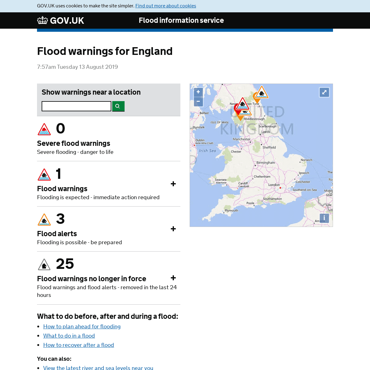
Flood information service FLOOD WARNINGS FOR ENGLAND 7:57am Tuesday 13 August 2019 SHOW WARNINGS NEAR A LOCATION Search by postcode or town Postcode or town Apply __ _ Severe flood warnings _ 0 Severe flood warnings Severe flooding - danger to life __ _ Flood warnings _ 1 Flood warnings Flooding is expected - immediate action required* Keswick Campsite
__ _ Flood alerts _ 3 Flood alerts Flooding is possible - be prepared * Rivers Brathay, Rothay and Winster * Rivers Pont and Blyth * Upper River Derwent, Stonethwaite Beck and Derwent Water __ _ Flood warnings no longer in force _ 25 Flood warnings no longerin force
Flood warnings and flood alerts - removed in the last 24 hours * Coastal Rivers in North Northumberland * East Somerset Rivers* Lower River Eden
* Lower River Swale
* Lower River Ure
* Middle River Eden
* Ouseburn and estuarine tributaries * River Chew Catchment * River Cole and Dorcan Brook * River Eden at Carlisle, Rickerby Park, Swifts and Stoneyholme GolfCourses
* River North Tyne
* River Rede
* Rivers Caldew and Petteril * Rivers Cocker, Marron and Derwent * Rivers Ehen, Calder, Irt and Esk * Rivers Esk and Irthing * Rivers Greta, St Johns Beck and Bassenthwaite Lake * Rivers Kent and Bela * Rivers Lowther and Eamont * Rivers Wampool and Ellen * Tidal River Ouse from Naburn Lock to Selby * Upper River Coquet* Upper River Eden
* Upper River Ouse
* Witham in South Kesteven+−
⇧
*
* © 2019 Microsoft Corporation* © 2019 HERE
* Terms of Use
i
YOU'RE MISSING OUT. A MAP SHOULD BE VISIBLE HERE. Javascript must be enabled. Use of Internet Explorer requires version 9 or later to access maps. What to do before, after and during a flood: * How to plan ahead for flooding * What to do in a flood * How to recover after a floodYou can also:
* View the latest river and sea levels near you * View your property's long term risk of flooding * View the 5-day flood risk * Sign up for flood warnings Other ways to get flood warning information For current flood warnings in force please call our 24-hour Floodlineon:
* Telephone: 0345 988 1188 * Type talk: 0345 602 6340 _(for the hard of hearing)_ Find out more about call charges FLOOD INFORMATION FOR NORTHERN IRELAND, SCOTLAND AND WALES Northern Ireland Direct Scottish Environment Protection Agency Natural Resources Wales HOW USEFUL WAS THIS INFORMATION? Your feedback will help us improve this serviceSUPPORT LINKS
* Help
* Cookies
* Privacy notice
* Terms and conditions* Contact
* Roadmap
* Cymraeg
* Built by the Environment Agency Open Government Licence All content is available under the Open Government Licence v3.0,
except where otherwise stated� Crown copyright
Details
3