2
More Annotations


6


3
Favourite Annotations


4


6
Text
AAROADS - THE ONLINE HIGHWAY GUIDE!HIGHWAY GUIDESUPDATESBLOGFORUMALBUMSSHIELD GALLERY AARoads’ Interstate-Guide delves even further covering current, past and future routes within the system. While the web site initially covered routes with a brief overview and a collection of end photos, development of pages over time enhances our coverage to include more extensive historical write-ups, an outline of recent modernization and widening projects, and expansion of the Interstate
AAROADS FORUM
This board is for topics related to the forum itself. 6499 Posts. 394 Topics. Last post by index. in Re: Fixed Width Theme. on May 06, 2021,08:22:19 AM.
STATE ROUTE 20
Connecting the ocean fog with the sapphire waters of Lake Tahoe, State Route 20 is a major east-west highway in Northern California. SR 20 passes through a wide variety of landscapes in Northern California, including redwood forest, the largest natural lake wholly located within California (Clear Lake), the Central Valley, Gold Country andthe Sierra Nevada.
WYOMING @ AAROADS
HISTORICAL MAPS OF ARIZONA Historical Maps of Arizona. Several proposals for a state highway system were put into place before the first defined system in 1926. This is a 1919 proposal for the state highway system. Notice that what became US 66 did not exist east of Holbrook toward Lupton.INTERSTATE 80
The final segment of Interstate 80 in Utah opened on August 22, 1986 after a dedication ceremony held under an overpass west of Utah 68 (Redwood Road). Culminating 30 years of construction, the five mile section of I-80 between 5600 West and Utah 68 finished in Salt Lake County was the last for the entire 2,900 mile transcontinentalfreeway. 3
STATE ROUTE 99
State Route 99. Arizona 99 is the tale of a route with lofty ambitions, cut down by factors during the 1970s to leave the road as a relatively insignificant route in the State Highway System. Arizona 99 begins southeast of Winslow, traveling toward the city. After passing Winslow, a short multiplex with Interstate 40 leads to thecontinuation
STATE ROAD 399 / COUNTY ROAD 399 State Road 399 / County Road 399. State Road 399 previously connected U.S. 98 at Gulf Breeze with Pensacola Beach and Via De Luna Drive east to Gulf Islands National Seashore and Navarre. A jurisdictional shift from state to county maintenance occurred with the Bob Sikes Bridge across Santa Rosa Sound and portions of Pensacola Beach Boulevard KENTUCKY 9 - AA HIGHWAY - AAROADS - KENTUCKY Kentucky 9 - AA Highway. The AA Highway overlays all of Kentucky 9 southeast from Wilder to Vanceburg. The highway separates into branches with the eastern spur overlapping with Kentucky 10 to Quincy and U.S. 23 at Ashland and the southern spur extending Kentucky 9 southeast to Kentucky 1 & 7 at Grayson. The 137 mile highway systemvaries as an
STATE ROUTE 288 / DESERT TO TALL PINES HIGHWAY State Route 288 / Desert To Tall Pines Highway. Arizona 288 is a lightly used road that travels from Arizona 188 near Roosevelt Dam to Young, AZ. The road is primarily a dirt highway, with some paved sections, and is narrow and winding. Arizona 288 was added to AAROADS - THE ONLINE HIGHWAY GUIDE!HIGHWAY GUIDESUPDATESBLOGFORUMALBUMSSHIELD GALLERY AARoads’ Interstate-Guide delves even further covering current, past and future routes within the system. While the web site initially covered routes with a brief overview and a collection of end photos, development of pages over time enhances our coverage to include more extensive historical write-ups, an outline of recent modernization and widening projects, and expansion of the InterstateAAROADS FORUM
This board is for topics related to the forum itself. 6499 Posts. 394 Topics. Last post by index. in Re: Fixed Width Theme. on May 06, 2021,08:22:19 AM.
STATE ROUTE 20
Connecting the ocean fog with the sapphire waters of Lake Tahoe, State Route 20 is a major east-west highway in Northern California. SR 20 passes through a wide variety of landscapes in Northern California, including redwood forest, the largest natural lake wholly located within California (Clear Lake), the Central Valley, Gold Country andthe Sierra Nevada.
WYOMING @ AAROADS
HISTORICAL MAPS OF ARIZONA Historical Maps of Arizona. Several proposals for a state highway system were put into place before the first defined system in 1926. This is a 1919 proposal for the state highway system. Notice that what became US 66 did not exist east of Holbrook toward Lupton.INTERSTATE 80
The final segment of Interstate 80 in Utah opened on August 22, 1986 after a dedication ceremony held under an overpass west of Utah 68 (Redwood Road). Culminating 30 years of construction, the five mile section of I-80 between 5600 West and Utah 68 finished in Salt Lake County was the last for the entire 2,900 mile transcontinentalfreeway. 3
STATE ROUTE 99
State Route 99. Arizona 99 is the tale of a route with lofty ambitions, cut down by factors during the 1970s to leave the road as a relatively insignificant route in the State Highway System. Arizona 99 begins southeast of Winslow, traveling toward the city. After passing Winslow, a short multiplex with Interstate 40 leads to thecontinuation
STATE ROAD 399 / COUNTY ROAD 399 State Road 399 / County Road 399. State Road 399 previously connected U.S. 98 at Gulf Breeze with Pensacola Beach and Via De Luna Drive east to Gulf Islands National Seashore and Navarre. A jurisdictional shift from state to county maintenance occurred with the Bob Sikes Bridge across Santa Rosa Sound and portions of Pensacola Beach Boulevard KENTUCKY 9 - AA HIGHWAY - AAROADS - KENTUCKY Kentucky 9 - AA Highway. The AA Highway overlays all of Kentucky 9 southeast from Wilder to Vanceburg. The highway separates into branches with the eastern spur overlapping with Kentucky 10 to Quincy and U.S. 23 at Ashland and the southern spur extending Kentucky 9 southeast to Kentucky 1 & 7 at Grayson. The 137 mile highway systemvaries as an
STATE ROUTE 288 / DESERT TO TALL PINES HIGHWAY State Route 288 / Desert To Tall Pines Highway. Arizona 288 is a lightly used road that travels from Arizona 188 near Roosevelt Dam to Young, AZ. The road is primarily a dirt highway, with some paved sections, and is narrow and winding. Arizona 288 was added toSTATE ROUTE 20
Connecting the ocean fog with the sapphire waters of Lake Tahoe, State Route 20 is a major east-west highway in Northern California. SR 20 passes through a wide variety of landscapes in Northern California, including redwood forest, the largest natural lake wholly located within California (Clear Lake), the Central Valley, Gold Country andthe Sierra Nevada.
FOLEY BEACH EXPRESS / BALDWIN BEACH EXPRESS Foley Beach Express. Traveling 13.5 miles between Orange Beach and Alabama 59 north of Foley, the Foley Beach Express consists of a four-lane expressway and two-lane toll bridge over the Intracoastal Waterway (Portage Creek). The expressway was laid across vastly undeveloped land to the east of Foley and the busy AL 59 corridor.INTERSTATE 15
Interstate 15 is the most important north-south corridor in Utah, passing through the heart of the Beehive State. Originating at the north end of the Virgin River Gorge, Interstate 15 immediately enters St. George, then proceeds north to Cedar City, Beaver and Cove Fort, where I-70 east begins. U.S. 191 - AAROADS - ARIZONA U.S. 191 is a scenic road between Clifton and Alpine, but one to be taken slowly. Some observers have counted over 400 curves along the 90 miles of road between the two, most of which must be taken at 25 MPH or less. The section of U.S. 191 north of Clifton was rerouted in 1974 due to growth at the Morenci mine.STATE ROUTE 4 EAST
State Route 4 East - Alpine County. Postmiles for California 4 along the Ebbetts Pass National Scenic Byway acquired from the official byway website. California 4 east. Eastbound California 4 (Ebbetts Pass Highway) enters the unincorporated community of Bear Valley, home of Bear Valley Mountain Resort, just east of the county line. 07/18/09. U.S. 441 - AAROADS - GEORGIA U.S. 129 combines with U.S. 441 north from Eatonton to Madison, Watkinsville and Athens. The northernmost portion of their overlap was realigned onto the Athens Perimeter Highway with U.S. 29 to bypass Downtown to the east per AASHTO on June 25, 1979. North at Commerce, AASHTO approved the realignment of U.S. 441 onto a four-lane bypass tothe
U.S. 395 - AAROADS - CALIFORNIA HIGHWAYS U.S. 395 is a major north-south route that traces the eastern slope of the Sierra Nevada and Cascade Mountains for its journey through California and Nevada. U.S. 395 begins at its interchange with Interstate 15 in Hesperia (Exit 141) and travels north alongINTERSTATE 25 NORTH
Interstate 25 North - Santa Fe County. North. Paralleling I-25 northeast to Exit 264, NM 16 originates along the east side frontage road in the Rio Galisteo valley. The 10.49 mile long highway follows El Camino Real northwest to NM 22 in Cochito Pueblo. 04/28/17. A diamond interchange joins NM 16 (El Camino Real) with Interstate 25 atExit 264.
STATE ROAD 589
The Suncoast Parkway extends State Road 589 northward through Pasco County to Brooksville and U.S. 98 near the Citrus County line. Work commenced on a two phase $507 million project in Summer 1998. The first phase was finished in February 2001 between the Veterans Expressway and SR 50 between Weeki Wachee and Brooksville. Completionfollowed in
U.S. 17 - AAROADS - FLORIDA U.S. 17. Stretching 317 miles through Florida, U.S. 17 generally travels along the spine and heartland of the Florida peninsula. The route connects the southwest coast with both the central and northeast portions of the state. Though a bit slower travel time than both Interstate 75 and I-4, U.S. 17 provides a more direct link between theFort
AAROADS - THE ONLINE HIGHWAY GUIDE!HIGHWAY GUIDESUPDATESBLOGFORUMALBUMSSHIELD GALLERY AARoads’ Interstate-Guide delves even further covering current, past and future routes within the system. While the web site initially covered routes with a brief overview and a collection of end photos, development of pages over time enhances our coverage to include more extensive historical write-ups, an outline of recent modernization and widening projects, and expansion of the InterstateAAROADS FORUM
This board is for topics related to the forum itself. 6499 Posts. 394 Topics. Last post by index. in Re: Fixed Width Theme. on May 06, 2021,08:22:19 AM.
STATE ROUTE 20
Connecting the ocean fog with the sapphire waters of Lake Tahoe, State Route 20 is a major east-west highway in Northern California. SR 20 passes through a wide variety of landscapes in Northern California, including redwood forest, the largest natural lake wholly located within California (Clear Lake), the Central Valley, Gold Country andthe Sierra Nevada.
STATE ROAD 44
State Road 44. Florida State Road 44 is a cross-peninsular route with two main sections totaling 103 miles east from in Crystal River to the Atlantic Ocean in New Smyrna Beach. The western portion links Citrus County with Wildwood and Leesburg in Sumter County. The eastern segment joins the Eustis and Mt. Dora area with DeLand and New SmyrnaBeach.
HISTORICAL MAPS OF ARIZONA Historical Maps of Arizona. Several proposals for a state highway system were put into place before the first defined system in 1926. This is a 1919 proposal for the state highway system. Notice that what became US 66 did not exist east of Holbrook toward Lupton. U.S. 1 - AAROADS - PENNSYLVANIA The realignment of U.S. 1 onto the short freeway was approved by the American Association of State Highway Officials (AASHO) on July 5, 1966. The remaining 16.05 miles of the bypass southwest to the Maryland state line was approved as the new alignment of U.S. 1by AASHO on November 7, 1970. The Media Bypass was completed in 1959.U.S. 522 NORTH
Northbound U.S. 522 (Taylor Highway) reaches SR 55 at this traffic signal in Front Royal. Incorporated in 1788, Front Royal has over 15,000 residents and is the seat of Warren County. The Canoe Capital of Virginia, Front Royal is also known as "Where the Skyline DriveBegins." 06/06/04.
INTERSTATE 95 NORTH
Interstate 95 North - Bucks County. North. PA 63 (Woodhaven Road) stems northwest from a trumpet interchange (Exit 35) with Interstate 95 along a freeway 3.3 miles to U.S. 1 (Roosevelt Boulevard) at Byberry in Philadelphia. 12/19/17. Original plans for the freeway along Woodhaven Road extended it northwest from I-95 to the Pennsylvania TurnpikeSTATE ROAD 295
Florida State Road 295 forms a ring around southwest Pensacola. The four to six lane route loops northward from the Main Gate to Pensacola Naval Air Station through Warrington to West Pensacola and Ninth Avenue in the city. This includes a short expressway segment (New Warrington Spur) at U.S. 90 and SR 727 (Fairfield Drive).STATE ROUTE 4 EAST
State Route 4 East - Alpine County. Postmiles for California 4 along the Ebbetts Pass National Scenic Byway acquired from the official byway website. California 4 east. Eastbound California 4 (Ebbetts Pass Highway) enters the unincorporated community of Bear Valley, home of Bear Valley Mountain Resort, just east of the county line. 07/18/09. AAROADS - THE ONLINE HIGHWAY GUIDE!HIGHWAY GUIDESUPDATESBLOGFORUMALBUMSSHIELD GALLERY AARoads’ Interstate-Guide delves even further covering current, past and future routes within the system. While the web site initially covered routes with a brief overview and a collection of end photos, development of pages over time enhances our coverage to include more extensive historical write-ups, an outline of recent modernization and widening projects, and expansion of the InterstateAAROADS FORUM
This board is for topics related to the forum itself. 6499 Posts. 394 Topics. Last post by index. in Re: Fixed Width Theme. on May 06, 2021,08:22:19 AM.
STATE ROUTE 20
Connecting the ocean fog with the sapphire waters of Lake Tahoe, State Route 20 is a major east-west highway in Northern California. SR 20 passes through a wide variety of landscapes in Northern California, including redwood forest, the largest natural lake wholly located within California (Clear Lake), the Central Valley, Gold Country andthe Sierra Nevada.
STATE ROAD 44
State Road 44. Florida State Road 44 is a cross-peninsular route with two main sections totaling 103 miles east from in Crystal River to the Atlantic Ocean in New Smyrna Beach. The western portion links Citrus County with Wildwood and Leesburg in Sumter County. The eastern segment joins the Eustis and Mt. Dora area with DeLand and New SmyrnaBeach.
HISTORICAL MAPS OF ARIZONA Historical Maps of Arizona. Several proposals for a state highway system were put into place before the first defined system in 1926. This is a 1919 proposal for the state highway system. Notice that what became US 66 did not exist east of Holbrook toward Lupton. U.S. 1 - AAROADS - PENNSYLVANIA The realignment of U.S. 1 onto the short freeway was approved by the American Association of State Highway Officials (AASHO) on July 5, 1966. The remaining 16.05 miles of the bypass southwest to the Maryland state line was approved as the new alignment of U.S. 1by AASHO on November 7, 1970. The Media Bypass was completed in 1959.U.S. 522 NORTH
Northbound U.S. 522 (Taylor Highway) reaches SR 55 at this traffic signal in Front Royal. Incorporated in 1788, Front Royal has over 15,000 residents and is the seat of Warren County. The Canoe Capital of Virginia, Front Royal is also known as "Where the Skyline DriveBegins." 06/06/04.
INTERSTATE 95 NORTH
Interstate 95 North - Bucks County. North. PA 63 (Woodhaven Road) stems northwest from a trumpet interchange (Exit 35) with Interstate 95 along a freeway 3.3 miles to U.S. 1 (Roosevelt Boulevard) at Byberry in Philadelphia. 12/19/17. Original plans for the freeway along Woodhaven Road extended it northwest from I-95 to the Pennsylvania TurnpikeSTATE ROAD 295
Florida State Road 295 forms a ring around southwest Pensacola. The four to six lane route loops northward from the Main Gate to Pensacola Naval Air Station through Warrington to West Pensacola and Ninth Avenue in the city. This includes a short expressway segment (New Warrington Spur) at U.S. 90 and SR 727 (Fairfield Drive).STATE ROUTE 4 EAST
State Route 4 East - Alpine County. Postmiles for California 4 along the Ebbetts Pass National Scenic Byway acquired from the official byway website. California 4 east. Eastbound California 4 (Ebbetts Pass Highway) enters the unincorporated community of Bear Valley, home of Bear Valley Mountain Resort, just east of the county line. 07/18/09.STATE ROUTE 20
Connecting the ocean fog with the sapphire waters of Lake Tahoe, State Route 20 is a major east-west highway in Northern California. SR 20 passes through a wide variety of landscapes in Northern California, including redwood forest, the largest natural lake wholly located within California (Clear Lake), the Central Valley, Gold Country andthe Sierra Nevada.
HISTORIC U.S. 40
Beyond Donner Pass in the Sierra Nevada, Historic U.S. 40 follows Donner Pass Road through the town of Truckee. Truckee sits at an elevation of 5,817 feet and was incorporated on March 23, 1993. 07/21/09. Historic U.S. 40 (Donner Pass Road) shifts southeast to meet Interstate 80 at Exit 186 en route to Downtown Truckee. 07/21/09.STATE ROUTE 99
State Route 99. Arizona 99 is the tale of a route with lofty ambitions, cut down by factors during the 1970s to leave the road as a relatively insignificant route in the State Highway System. Arizona 99 begins southeast of Winslow, traveling toward the city. After passing Winslow, a short multiplex with Interstate 40 leads to thecontinuation
STATE ROAD 112
The Airport Expressway (Florida State Road 112) is a six- to eight-lane freeway from Miami International Airport (MIA) east to Interstate 95 and Interstate 195 for a distance of 5.4 miles. It is maintained by the Miami-Dade Expressway Authority. The freeway parallels NW 36th Street for its entire length, which runs to the south of the expressway. U.S. 276 - AAROADS - NORTH CAROLINA U.S. 276 connects the Transylvania County seat of Brevard with the Haywood County seat of Waynesville in Western North Carolina. Entering the Tar Heel State across the Blue Ridge Mountains at Jones Gap, U.S. 276 measures 63.16 miles north to Interstate 40 at Cove Creek. U.S. 441 - AAROADS - GEORGIA U.S. 129 combines with U.S. 441 north from Eatonton to Madison, Watkinsville and Athens. The northernmost portion of their overlap was realigned onto the Athens Perimeter Highway with U.S. 29 to bypass Downtown to the east per AASHTO on June 25, 1979. North at Commerce, AASHTO approved the realignment of U.S. 441 onto a four-lane bypass tothe
STATE ROUTE 330
State Route 330. California 330 travels between California 210 at Highland and California 18 at Running Springs. It is among the faster routes to the Big Bear and Lake Arrowhead resorts. The state route consists of a remnant of the original route of California 30, which used to turn northeast at Highland and head toward Running Springsrather
STATE ROUTE 7 NORTH
The Christiana Bypass for SR 273 was constructed in the mid 1980s to move traffic away from Main Street (SR 7). The arterial route joins Christiana with Ogletown, I-95 and Newark to the west and Hares Corner, U.S. 13 (Dupont Highway) and New Castle to the east. 06/17/12. Following E Main Street north from SR 273, SR 7 approaches Christiana.STATE ROAD 436
Florida State Road 436 Guides. North/south cardinal directions are used for SR 436 within Orange County. The Seminole County portion is marked with east/west banners. Douglas Avenue constitutes a west side frontage road for Interstate 4 between SR 434 and SR 436 (Semoran Boulevard) in Altamonte Springs. The road meets SR 436 across fromWymore
STATE HIGHWAY 13
State Highway 13. Colorado 13 totals 128.07 miles from Rifle in Garfield County, to the Wyoming state line well north of Craig. Prior to 1984, Colorado 13 was cosigned in its entirety with Colorado 789, the Mexico-Canada Highway. Wyoming 789 is still in place north from Moffat County, Colorado. Heading north through Rifle, SH 13 begins atI-70
AAROADS - THE ONLINE HIGHWAY GUIDE!HIGHWAY GUIDESUPDATESBLOGFORUMALBUMSSHIELD GALLERY AARoads’ Interstate-Guide delves even further covering current, past and future routes within the system. While the web site initially covered routes with a brief overview and a collection of end photos, development of pages over time enhances our coverage to include more extensive historical write-ups, an outline of recent modernization and widening projects, and expansion of the InterstateAAROADS FORUM
This board is for topics related to the forum itself. 6499 Posts. 394 Topics. Last post by index. in Re: Fixed Width Theme. on May 06, 2021,08:22:19 AM.
HISTORICAL MAPS OF ARIZONA Historical Maps of Arizona. Several proposals for a state highway system were put into place before the first defined system in 1926. This is a 1919 proposal for the state highway system. Notice that what became US 66 did not exist east of Holbrook toward Lupton.STATE ROUTE 64
The road was extended in 1932 from the Grand Canyon south to Williams and U.S. 66, paralleling the Grand Canyon Railway. Between 1961 and 1963, Arizona 64 was extended north through Tuba City and Tees Nos Pos, to the New Mexico state line. This section of highway was transferred to U.S. 164 in 1966 (now U.S. 160). Use headlights allhours of
FOLEY BEACH EXPRESS / BALDWIN BEACH EXPRESS U.S. 17 - AAROADS - VIRGINIA SR 165 is a circuitous route in Hampton Roads leading west from U.S. 17 along Moses Grandy Trail to U.S. 17 Business at Deep Creek and east on Cedar Road to SR 168 Business (Battlefield Boulevard). U.S. 17 (Dominion Boulevard) upgrades to a limited access highway from SR 165 northeast to SR 168 (Oak Grove Connector).STATE ROUTE 299
California 299 is a major east-west corridor from the Arcata-Eureka area in Humboldt County on the Pacific Coast to the Nevada state line east of Alturas. The state route connects Weaverville, Redding, Blue Lake and Willow Creek. California 299 also serves Trinity County, a remote area between the coast and the well-traveled Interstate 5corridor.
STATE ROAD 281
Bo's Bridge was officially named the Garcon Point Bridge in March 1998. This name was selected over another proposal, the Santa Rosa Bay Bridge. 3 Tolls on the bridge have been suspended during hurricanes to aid in evacuation and also due to other emergency detours, such as the closure of State Road 87 due to wildfires. This was the case from the time preceding the September 15, 2004 landfall U.S. 301 - AAROADS - FLORIDA U.S. 27/441 combine with U.S. 301 at Belleview for an overlap into Downtown Ocala. Leading north into Belleview, planned construction will widen a 2.37 mile section from north of CR 42 to south of 134th Place to four lanes. U.S. 27 turns west from U.S. 301/441 at STATE ROAD 399 / COUNTY ROAD 399 State Road 399 / County Road 399. State Road 399 previously connected U.S. 98 at Gulf Breeze with Pensacola Beach and Via De Luna Drive east to Gulf Islands National Seashore and Navarre. A jurisdictional shift from state to county maintenance occurred with the Bob Sikes Bridge across Santa Rosa Sound and portions of Pensacola Beach Boulevard AAROADS - THE ONLINE HIGHWAY GUIDE!HIGHWAY GUIDESUPDATESBLOGFORUMALBUMSSHIELD GALLERY AARoads’ Interstate-Guide delves even further covering current, past and future routes within the system. While the web site initially covered routes with a brief overview and a collection of end photos, development of pages over time enhances our coverage to include more extensive historical write-ups, an outline of recent modernization and widening projects, and expansion of the InterstateAAROADS FORUM
This board is for topics related to the forum itself. 6499 Posts. 394 Topics. Last post by index. in Re: Fixed Width Theme. on May 06, 2021,08:22:19 AM.
HISTORICAL MAPS OF ARIZONA Historical Maps of Arizona. Several proposals for a state highway system were put into place before the first defined system in 1926. This is a 1919 proposal for the state highway system. Notice that what became US 66 did not exist east of Holbrook toward Lupton.STATE ROUTE 64
The road was extended in 1932 from the Grand Canyon south to Williams and U.S. 66, paralleling the Grand Canyon Railway. Between 1961 and 1963, Arizona 64 was extended north through Tuba City and Tees Nos Pos, to the New Mexico state line. This section of highway was transferred to U.S. 164 in 1966 (now U.S. 160). Use headlights allhours of
FOLEY BEACH EXPRESS / BALDWIN BEACH EXPRESS U.S. 17 - AAROADS - VIRGINIA SR 165 is a circuitous route in Hampton Roads leading west from U.S. 17 along Moses Grandy Trail to U.S. 17 Business at Deep Creek and east on Cedar Road to SR 168 Business (Battlefield Boulevard). U.S. 17 (Dominion Boulevard) upgrades to a limited access highway from SR 165 northeast to SR 168 (Oak Grove Connector).STATE ROUTE 299
California 299 is a major east-west corridor from the Arcata-Eureka area in Humboldt County on the Pacific Coast to the Nevada state line east of Alturas. The state route connects Weaverville, Redding, Blue Lake and Willow Creek. California 299 also serves Trinity County, a remote area between the coast and the well-traveled Interstate 5corridor.
STATE ROAD 281
Bo's Bridge was officially named the Garcon Point Bridge in March 1998. This name was selected over another proposal, the Santa Rosa Bay Bridge. 3 Tolls on the bridge have been suspended during hurricanes to aid in evacuation and also due to other emergency detours, such as the closure of State Road 87 due to wildfires. This was the case from the time preceding the September 15, 2004 landfall U.S. 301 - AAROADS - FLORIDA U.S. 27/441 combine with U.S. 301 at Belleview for an overlap into Downtown Ocala. Leading north into Belleview, planned construction will widen a 2.37 mile section from north of CR 42 to south of 134th Place to four lanes. U.S. 27 turns west from U.S. 301/441 at STATE ROAD 399 / COUNTY ROAD 399 State Road 399 / County Road 399. State Road 399 previously connected U.S. 98 at Gulf Breeze with Pensacola Beach and Via De Luna Drive east to Gulf Islands National Seashore and Navarre. A jurisdictional shift from state to county maintenance occurred with the Bob Sikes Bridge across Santa Rosa Sound and portions of Pensacola Beach Boulevard FOLEY BEACH EXPRESS / BALDWIN BEACH EXPRESS Foley Beach Express. Traveling 13.5 miles between Orange Beach and Alabama 59 north of Foley, the Foley Beach Express consists of a four-lane expressway and two-lane toll bridge over the Intracoastal Waterway (Portage Creek). The expressway was laid across vastly undeveloped land to the east of Foley and the busy AL 59 corridor. LOOP 202 - SANTAN FREEWAY - AAROADS - ARIZONA Loop 202 - Santan Freeway. Part of the overall Loop 202 beltway system through the East and West valleys, the Santan Freeway travels 24.80 miles between the Maricopa Freeway (I-10) in southern reaches of Phoenix and the Superstition Freeway (U.S. 60) in east Mesa, opposite the Red Mountain Freeway. The urban freeway serves to connect Chandler U.S. 301 - AAROADS - FLORIDA U.S. 27/441 combine with U.S. 301 at Belleview for an overlap into Downtown Ocala. Leading north into Belleview, planned construction will widen a 2.37 mile section from north of CR 42 to south of 134th Place to four lanes. U.S. 27 turns west from U.S. 301/441 at U.S. 441 - AAROADS - GEORGIA U.S. 129 combines with U.S. 441 north from Eatonton to Madison, Watkinsville and Athens. The northernmost portion of their overlap was realigned onto the Athens Perimeter Highway with U.S. 29 to bypass Downtown to the east per AASHTO on June 25, 1979. North at Commerce, AASHTO approved the realignment of U.S. 441 onto a four-lane bypass tothe
U.S. 331 - AAROADS - ALABAMA U.S. 331. U.S. 331 travels 103 miles north from the Florida state line near Florala to Montgomery in south central Alabama. The rural highway links Opp with the town of Brantley and the Crenshaw County seat of Luverne. The north end was relocated south from Downtown Montgomery to U.S. 80-82 and SR 21 on South Boulevard with approval by theINTERSTATE 80
The final segment of Interstate 80 in Utah opened on August 22, 1986 after a dedication ceremony held under an overpass west of Utah 68 (Redwood Road). Culminating 30 years of construction, the five mile section of I-80 between 5600 West and Utah 68 finished in Salt Lake County was the last for the entire 2,900 mile transcontinentalfreeway. 3
STATE ROAD 77
Subsequent road work ( Project 217909-6) starting in late 2020 will widen the 3.481 mile stretch of SR 77 through the town of Wausau from two lanes to a five-lane urban boulevard. The estimated $31.2 million project will take 2.5 years to complete. Project 217909-3 expands the six mile section between the Bay County line and a point north of CRSTATE ROAD 23
State Road 23 - First Coast Expressway South. South. Ramps connect U.S. 90 (Beaver Street) with the First Coast Expressway south of a CSX Railroad line. Opened on September 18, 2018, the extension of SR 23 serves truck traffic along U.S. 90 from the town of Baldwin and the Otis community of Jacksonville. 01/20/19. 2 photos.WYOMING @ AAROADS
U.S. 287 north; Still in Colorado, the state line with Wyoming is noticeable due to the change in asphalt color. A small turnout is located on the east side of the highway for a Wyoming historical marker for the Overland Trail crossing. U.S. 30 - AAROADS - INDIANA A view of U.S. 30 (Joliet Street) in the town of Dyer at the bridge over Hart Ditch. This bridge was a part of the Ideal Section of the Lincoln Highway built between the years of 1922 and 1923 and has remained standing along with the rest of U.S. 30 across Dyer. 05/24/10. Photo Credits: 05/28/09, 08/16/09, 04/09/10, 05/24/10,05/30/10 by Thomas
AAROADS - THE ONLINE HIGHWAY GUIDE!HIGHWAY GUIDESUPDATESBLOGFORUMALBUMSSHIELD GALLERY AARoads’ Interstate-Guide delves even further covering current, past and future routes within the system. While the web site initially covered routes with a brief overview and a collection of end photos, development of pages over time enhances our coverage to include more extensive historical write-ups, an outline of recent modernization and widening projects, and expansion of the InterstateOUR LATEST UPDATES
Delaware @ AARoads – Delaware 92 – split coverage into east and westbound photos, with new photos added from June 2012 and December 2016. Delaware @ AARoads – Delaware 100 – updated guide with new photos in both directions (December 2016). Updated pages for Delaware 34, 261, 491 and 896 Business. February 27, 2017.AAROADS FORUM
This board is for topics related to the forum itself. 6499 Posts. 394 Topics. Last post by index. in Re: Fixed Width Theme. on May 06, 2021,08:22:19 AM.
GENERAL HIGHWAY TALK Topics about signs, signals, laws, and other traffic control devices. 118171 Posts. 1662 Topics. Last post by paulthemapguy. in Re: Road Sign UNO. on Today atSTATE ROUTE 20
Connecting the ocean fog with the sapphire waters of Lake Tahoe, State Route 20 is a major east-west highway in Northern California. SR 20 passes through a wide variety of landscapes in Northern California, including redwood forest, the largest natural lake wholly located within California (Clear Lake), the Central Valley, Gold Country andthe Sierra Nevada.
HISTORICAL MAPS OF ARIZONA Historical Maps of Arizona. Several proposals for a state highway system were put into place before the first defined system in 1926. This is a 1919 proposal for the state highway system. Notice that what became US 66 did not exist east of Holbrook toward Lupton.STATE ROAD 77
Subsequent road work ( Project 217909-6) starting in late 2020 will widen the 3.481 mile stretch of SR 77 through the town of Wausau from two lanes to a five-lane urban boulevard. The estimated $31.2 million project will take 2.5 years to complete. Project 217909-3 expands the six mile section between the Bay County line and a point north of CR U.S. 98 - AAROADS - ALABAMAFLORIDA HIGHWAY 98HIGHWAY 158 EXPANSION ALABAMAUS 98 FLORIDA U.S. 98 joins the city of Mobile area with Hattiesburg, Mississippi as part of a regional corridor northwest to Jackson. East from the Port City, U.S. 98 constitutes both an alternate to Interstate 10 (Mobile Bayway) and a commuter route to Spanish Fort, Daphne and Fairhope. CALIFORNIA @ AAROADS California 178. Scenic California 178 leads east through the Kern River Canyon, which is a narrow canyon crafted by the waters of the Kern River. Falling rocks are a concern along certain sections of the highway. Photo taken by Erik Fox (10/15/06). California 178 begins at the Junction of California 58 and California 99 in Bakersfield. LAKE COUNTY ROAD 561 Lake County Road 561. Two branches of County Road 561 are assigned in Lake County. The southern leg stretches 11.97 miles north from SR 33 to Lake Gloria, Lake Minnehaha and Minneola Avenue at CR 561A (12th Street) west of Downtown Clermont. The 12.26-mile long northern section branches east from U.S. 27 to Sugarloaf Mountain, Astatula andSR
HISTORICAL MAPS OF ARIZONA Historical Maps of Arizona. Several proposals for a state highway system were put into place before the first defined system in 1926. This is a 1919 proposal for the state highway system. Notice that what became US 66 did not exist east of Holbrook toward Lupton.STATE ROUTE 95
Southbound SR 95 at CR 227. Mohave County Route 227 follows the old alignment of SR 95, culminating at Historic U.S. 66 in Topock near Interstate 40. 02/16/04. At this intersection, note the trailblazer for Interstate 40 Arizona. Trouble is, continuing straight south on SR 95 will actually connect to Interstate 40 California. 02/16/04.STATE HIGHWAY 6
State Highway 6. SH 6 is one of Texas' most important state highways, connecting Oklahoma with the Gulf Coast near Galveston along a 557 mile alignment. Construction along the concurrent section of SH 6 and SL 340 through Waco and Robinson converts more of the highway to limited access standards. The project includes a grade separation forOld
U.S. 21 - AAROADS - NORTH CAROLINA U.S. 21. U.S. 21 through North Carolina enters the state alongside Interstate 77 through Charlotte. The two overlap three times over the course of 90.1 miles from the South Carolina line to southern Surry County near Elkin. The remaining 34.3 miles head northwest from the I-77 corridor to Roaring Gap, the Alleghany County seat of Sparta andINTERSTATE 95 SOUTH
Interstate 95 crosses the Byram River into Port Chester, New York from Connecticut. Since Interstate 95 transitions into the New England Thruway of the New York Thruway System, the welcome sign, since replaced with a simpler design, featured the Statue of Liberty motif rather than the plain "Welcome to the Empire State" signs found at most state line crossings.STATE ROAD 589
The Suncoast Parkway extends State Road 589 northward through Pasco County to Brooksville and U.S. 98 near the Citrus County line. Work commenced on a two phase $507 million project in Summer 1998. The first phase was finished in February 2001 between the Veterans Expressway and SR 50 between Weeki Wachee and Brooksville. Completionfollowed in
STATE ROAD 674
State Road 674. A 25.51 mile long highway, State Road 674 ventures east from U.S. 41 in Ruskin to Sun City Center, Wimauma, Fort Lonesome and SR 37 in southwest Polk County. The state road provides freeway access to I-75 for the growing Ruskin and Sun City Center communities to the west. East of Wimauma, SR 674 constitutes a truck route forINTERSTATE 80
Interstate 80. The 2,900-mile cross country interstate that runs from San Francisco to New York City runs for 152 miles from Hammond at the Illinois border to near Angola at the Ohio border. Interstate 80 runs with Interstate 94 for 15 miles as part of the Borman Expressway through the suburbs of Northwest Indiana; the Borman is the busiest U.S. 17 - AAROADS - FLORIDA U.S. 17. Stretching 317 miles through Florida, U.S. 17 generally travels along the spine and heartland of the Florida peninsula. The route connects the southwest coast with both the central and northeast portions of the state. Though a bit slower travel time than both Interstate 75 and I-4, U.S. 17 provides a more direct link between theFort
STATE ROUTE 288 / DESERT TO TALL PINES HIGHWAY State Route 288 / Desert To Tall Pines Highway. Arizona 288 is a lightly used road that travels from Arizona 188 near Roosevelt Dam to Young, AZ. The road is primarily a dirt highway, with some paved sections, and is narrow and winding. Arizona 288 was added toSkip to content
* Highway Guides __
* A – H
* Alabama
* Arizona
* Arkansas
* California
* Colorado
* Connecticut
* Delaware
* District of Columbia (D.C.)* Florida
* Georgia
* Hawaii
* I – M
* Idaho
* Illinois
* Indiana
* Iowa
* Kansas
* Kentucky
* Louisiana
* Maine
* Maryland
* Massachusetts
* Michigan
* Mississippi
* Missouri
* Montana
* N – O
* Nebraska
* Nevada
* New Hampshire
* New Jersey
* New Mexico
* New York
* North Carolina
* North Dakota
* Ohio
* Oregon
* P – W
* Pennsylvania
* Rhode Island
* South Carolina
* South Dakota
* Tennessee
* Texas
* Utah
* Vermont
* Virginia
* Washington
* West Virginia
* Wisconsin
* Wyoming
* City/Area Guides __* A – E
* Albuquerque, NM
* Appleton, WI
* Austin, TX
* Bakersfield, CA
* Baltimore, MD
* Baton Rouge, LA
* Birmingham, AL
* Burlington, VT
* Corpus Christi, TX* Denver, CO
* Dover, DE
* Eau Claire, WI
* El Paso, TX
* Evansville, IN
* Eugene, OR
* F – M
* Florida Keys
* Fort Wayne, IN
* Green Bay, WI
* Hampton Roads, VA
* Harrisburg, PA
* Houston, TX
* Indianapolis, IN
* Jackson, MS
* Las Vegas, NV
* Louisville, KY
* Los Angeles, CA
* Miami, FL
* Mississippi Gulf Coast* Mobile, AL
* N – R
* Naples, FL
* New Orleans, LA
* Newark, DE
* North Carolina Outer Banks* Olympia, WA
* Omaha, NE-Council Bluffs, IA* Orlando, FL
* Pensacola, FL
* Philadelphia, PA
* Phoenix, AZ
* Pittsburgh, PA
* Portland, OR
* Reno-Sparks, NV
* Richmond-Petersburg, VA * Rio Grande Valley, TX* S – W
* Sacramento, CA
* Salt Lake City, UT* San Antonio, TX
* San Diego, CA
* San Francisco, CA
* Savannah, GA
* Spokane, WA
* Tampa Bay, FL
* Trenton, NJ
* Tri-Cities, WA
* Tucson, AZ
* Yakima, WA
* Washington, DC
* Western North Carolina Highways* Wilmington, DE
* Updates
* Blog
* Forum
* Albums
* Shield Gallery
* Search
* Highway Guides
* A – H
* Alabama
* Arizona
* Arkansas
* California
* Colorado
* Connecticut
* Delaware
* District of Columbia (D.C.)* Florida
* Georgia
* Hawaii
* I – M
* Idaho
* Illinois
* Indiana
* Iowa
* Kansas
* Kentucky
* Louisiana
* Maine
* Maryland
* Massachusetts
* Michigan
* Mississippi
* Missouri
* Montana
* N – O
* Nebraska
* Nevada
* New Hampshire
* New Jersey
* New Mexico
* New York
* North Carolina
* North Dakota
* Ohio
* Oregon
* P – W
* Pennsylvania
* Rhode Island
* South Carolina
* South Dakota
* Tennessee
* Texas
* Utah
* Vermont
* Virginia
* Washington
* West Virginia
* Wisconsin
* Wyoming
* City/Area Guides
* A – E
* Albuquerque, NM
* Appleton, WI
* Austin, TX
* Bakersfield, CA
* Baltimore, MD
* Baton Rouge, LA
* Birmingham, AL
* Burlington, VT
* Corpus Christi, TX* Denver, CO
* Dover, DE
* Eau Claire, WI
* El Paso, TX
* Evansville, IN
* Eugene, OR
* F – M
* Florida Keys
* Fort Wayne, IN
* Green Bay, WI
* Hampton Roads, VA
* Harrisburg, PA
* Houston, TX
* Indianapolis, IN
* Jackson, MS
* Las Vegas, NV
* Louisville, KY
* Los Angeles, CA
* Miami, FL
* Mississippi Gulf Coast* Mobile, AL
* N – R
* Naples, FL
* New Orleans, LA
* Newark, DE
* North Carolina Outer Banks* Olympia, WA
* Omaha, NE-Council Bluffs, IA* Orlando, FL
* Pensacola, FL
* Philadelphia, PA
* Phoenix, AZ
* Pittsburgh, PA
* Portland, OR
* Reno-Sparks, NV
* Richmond-Petersburg, VA * Rio Grande Valley, TX* S – W
* Sacramento, CA
* Salt Lake City, UT* San Antonio, TX
* San Diego, CA
* San Francisco, CA
* Savannah, GA
* Spokane, WA
* Tampa Bay, FL
* Trenton, NJ
* Tri-Cities, WA
* Tucson, AZ
* Yakima, WA
* Washington, DC
* Western North Carolina Highways* Wilmington, DE
* Updates
* Blog
* Forum
* Albums
* Shield Gallery
* Search
*
FROM THE WEST ...
*
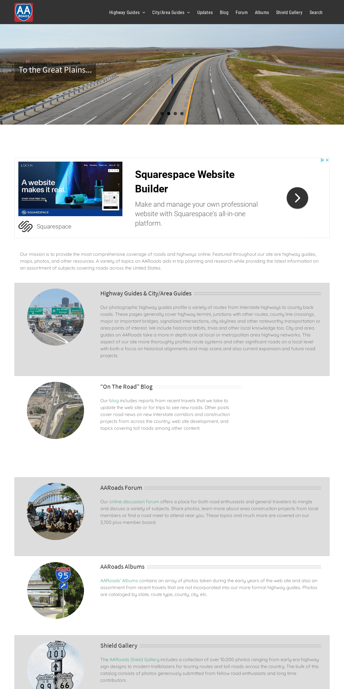
TO THE GREAT PLAINS...*
AND THE GULF COAST...*
... TO THE EAST
* 1
* 2
* 3
* 4
*
* �
AARoads – The Online Highway Guide!Alex 2019-09-10T16:39:38-04:00 Our mission is to provide the most comprehensive coverage of roads and highways online. Featured throughout our site are highway guides, maps, photos, and other resources. A variety of topics on AARoads aids in trip planning and research while providing the latest information on an assortment of subjects covering roads across the United States. HIGHWAY GUIDES & CITY/AREA GUIDES Our photographic highway guides profile a variety of routes from Interstate highways to county back roads. These pages generally cover highway termini, junctions with other routes, county line crossings, major or important bridges, signalized intersections, city skylines and other noteworthy transportation or area points of interest. We include historical tidbits, trivia and other local knowledge too. City and area guides on AARoads take a more in depth look at local or metropolitan area highway networks. This aspect of our site more thoroughly profiles route systems and other significant roads on a local level with both a focus on historical alignments and map scans and also current expansion and future road projects. “ON THE ROAD” BLOG Our blog includes reports from recent travels that we take to update the web site or for trips to see new roads. Other posts cover road news on new Interstate corridors and construction projects from across the country, web site development, and topics covering toll roads among other content.AAROADS FORUM
Our online discussion forum offers a place for both road enthusiasts and general travelers to mingle and discuss a variety of subjects. Share photos, learn more about area construction projects from local members or find a road meet to attend near you. These topics and much more are covered on our 3,700 plusmember board.
AAROADS ALBUMS
AARoads’ Albums contains an array of photos taken during the early years of the web site and also an assortment from recent travels that are not incorporated into our more formal highway guides. Photos are cataloged by state, route type,county, city, etc.
SHIELD GALLERY
The AARoads Shield Gallery includes a collection of over 10,000 photos ranging from early era highway sign designs to modern trailblazers for touring routes and toll roads across the country. The bulk of this catalog consists of photos generously submitted from fellow road enthusiasts and long timecontributors.
INTERSTATE-GUIDE
AARoads’ Interstate-Guide delves even further covering current, past and future routes within the system. While the web site initially covered routes with a brief overview and a collection of end photos, development of pages over time enhances our coverage to include more extensive historical write-ups, an outline of recent modernization and widening projects, and expansion of the Interstate system with the growth of the I-11, I-49, I-69 and other corridors.__
HIGHWAY FONTS
Road signs across the U.S. use one of two fonts: FHWA Highway Gothic or Clearview. The latter became the exclusive type for states such as Michigan, Pennsylvania and Texas, while municipalities in other states switched their street signs to the newer type face. Interim approval for the font was previously rescinded by an FHWA mandate in February 2016, but reinstated in March 2018.Read More
__
COLORED ROUTE MARKERS Florida was one of several states to use colored route markers to aid in motorist navigation. Arizona, Mississippi, South Dakota and Washington also used a colored route format, but Florida’s system was the most extensive and longest lasting, remaining in place until1993.
Read More
Be sure also to follow us on social media for the latest in road news from across the country, photos and roadtrip reports from the field and major site updates.* About
* Contact
* FAQ
* Spotlights
* Testimonials
* Interstate-Guide
CONNECT WITH AAROADSSEARCH
Search for:
� 2000-2020 AARoads.com | All Rights Reserved | Privacy Policy /Terms of Use
Go to Top
Details
5