1
More Annotations


2


6
Favourite Annotations


3


2
Text
AAROADS - THE ONLINE HIGHWAY GUIDE!HIGHWAY GUIDESUPDATESBLOGFORUMALBUMSSHIELD GALLERY AARoads’ Interstate-Guide delves even further covering current, past and future routes within the system. While the web site initially covered routes with a brief overview and a collection of end photos, development of pages over time enhances our coverage to include more extensive historical write-ups, an outline of recent modernization and widening projects, and expansion of the Interstate
OUR LATEST UPDATES
Updates March 7-12, 2021. Crossing the William Preston Lane, Jr Bridge across Chesapeake Bay on U.S. 50 west / U.S. 301 south. 12/31/16 Finished adding the last of the December 2020 photos to Delaware this past weekend, and proceeded west into Maryland and added the recent photos from there as well.AAROADS FORUM
Photos, Videos, and More. Post your links to your road-related photos, videos, and pages here, whether it's on your website, Flickr, or if you just want to upload a bunch of images somewhere and post your narrative in the thread itself. GENERAL HIGHWAY TALK Child Boards: Traffic Control. Topics about signs, signals, laws, and other traffic control devices. 118277 Posts 1662 Topics Last post by kphoger in Re: Road Sign UNO on Today at 02:29:31 PMSTATE ROUTE 20
Connecting the ocean fog with the sapphire waters of Lake Tahoe, State Route 20 is a major east-west highway in Northern California. SR 20 passes through a wide variety of landscapes in Northern California, including redwood forest, the largest natural lake wholly located within California (Clear Lake), the Central Valley, Gold Country andthe Sierra Nevada.
HISTORICAL MAPS OF ARIZONA Several proposals for a state highway system were put into place before the first defined system in 1926. This is a 1919 proposal for the state highway system.STATE ROAD 77
State Road 77 provides the second of three routes joining Panama City and the Panama City Beach area with I-10 in Northwest Florida. U.S. 98 - AAROADS - ALABAMAFLORIDA HIGHWAY 98HIGHWAY 158 EXPANSION ALABAMAUS 98 FLORIDA U.S. 98 joins the city of Mobile area with Hattiesburg, Mississippi as part of a regional corridor northwest to Jackson. East from the Port City, U.S. 98 constitutes both an alternate to Interstate 10 (Mobile Bayway) and a commuter route to Spanish Fort, Daphne and Fairhope. CALIFORNIA @ AAROADS Scenic California 178 leads east through the Kern River Canyon, which is a narrow canyon crafted by the waters of the Kern River. Falling rocks are a concern along certain sections of the highway. LAKE COUNTY ROAD 561 Two branches of County Road 561 are assigned in Lake County. The southern leg stretches 11.97 miles north from SR 33 to Lake Gloria, Lake Minnehaha and Minneola Avenue at CR 561A (12th Street) west ofDowntown Clermont.
AAROADS - THE ONLINE HIGHWAY GUIDE!HIGHWAY GUIDESUPDATESBLOGFORUMALBUMSSHIELD GALLERY AARoads’ Interstate-Guide delves even further covering current, past and future routes within the system. While the web site initially covered routes with a brief overview and a collection of end photos, development of pages over time enhances our coverage to include more extensive historical write-ups, an outline of recent modernization and widening projects, and expansion of the InterstateOUR LATEST UPDATES
Delaware @ AARoads – Delaware 92 – split coverage into east and westbound photos, with new photos added from June 2012 and December 2016. Delaware @ AARoads – Delaware 100 – updated guide with new photos in both directions (December 2016). Updated pages for Delaware 34, 261, 491 and 896 Business. February 27, 2017.AAROADS FORUM
This board is for topics related to the forum itself. 6499 Posts. 394 Topics. Last post by index. in Re: Fixed Width Theme. on May 06, 2021,08:22:19 AM.
GENERAL HIGHWAY TALK Topics about signs, signals, laws, and other traffic control devices. 118171 Posts. 1662 Topics. Last post by paulthemapguy. in Re: Road Sign UNO. on Today atSTATE ROUTE 20
Connecting the ocean fog with the sapphire waters of Lake Tahoe, State Route 20 is a major east-west highway in Northern California. SR 20 passes through a wide variety of landscapes in Northern California, including redwood forest, the largest natural lake wholly located within California (Clear Lake), the Central Valley, Gold Country andthe Sierra Nevada.
HISTORICAL MAPS OF ARIZONA Historical Maps of Arizona. Several proposals for a state highway system were put into place before the first defined system in 1926. This is a 1919 proposal for the state highway system. Notice that what became US 66 did not exist east of Holbrook toward Lupton. CALIFORNIA @ AAROADS California 178. Scenic California 178 leads east through the Kern River Canyon, which is a narrow canyon crafted by the waters of the Kern River. Falling rocks are a concern along certain sections of the highway. Photo taken by Erik Fox (10/15/06). California 178 begins at the Junction of California 58 and California 99 in Bakersfield.STATE ROAD 77
Subsequent road work ( Project 217909-6) starting in late 2020 will widen the 3.481 mile stretch of SR 77 through the town of Wausau from two lanes to a five-lane urban boulevard. The estimated $31.2 million project will take 2.5 years to complete. Project 217909-3 expands the six mile section between the Bay County line and a point north of CR U.S. 98 - AAROADS - ALABAMAFLORIDA HIGHWAY 98HIGHWAY 158 EXPANSION ALABAMAUS 98 FLORIDA U.S. 98 joins the city of Mobile area with Hattiesburg, Mississippi as part of a regional corridor northwest to Jackson. East from the Port City, U.S. 98 constitutes both an alternate to Interstate 10 (Mobile Bayway) and a commuter route to Spanish Fort, Daphne and Fairhope. LAKE COUNTY ROAD 561 Lake County Road 561. Two branches of County Road 561 are assigned in Lake County. The southern leg stretches 11.97 miles north from SR 33 to Lake Gloria, Lake Minnehaha and Minneola Avenue at CR 561A (12th Street) west of Downtown Clermont. The 12.26-mile long northern section branches east from U.S. 27 to Sugarloaf Mountain, Astatula andSR
HISTORICAL MAPS OF ARIZONA Several proposals for a state highway system were put into place before the first defined system in 1926. This is a 1919 proposal for the state highway system.STATE ROUTE 95
Arizona State Roure 95 roughly parallels the Colorado River to the east, following an alignment that provides an alternative to U.S. 95 between Quartzsite and Bullhead City / Laughlin (with a connection viaNevada Route 163).
STATE HIGHWAY 6
SH 6 is one of Texas' most important state highways, connecting Oklahoma with the Gulf Coast near Galveston along a 557 milealignment.
INTERSTATE 95 SOUTH
Interstate 95 crosses the Byram River into Port Chester, New York from Connecticut. Since Interstate 95 transitions into the New England Thruway of the New York Thruway System, the welcome sign, since replaced with a simpler design, featured the Statue of Liberty motif rather than the plain "Welcome to the Empire State" signs found at most state line crossings.INTERSTATE 80
Westbound Ramp Closure at Exit 21. A detour was in effect for the westbound mainline of Interstate 80 from Exit 21 (Lake Station) to Exit 17 (Interstate 65). U.S. 17 - AAROADS - FLORIDA U.S. 17 begins at U.S. 41 in Downtown Punta Gorda and heads northerly toward Arcadia while paralleling the Peace River. Road projects spanning between 2003 to 2015 widened U.S. 17 into a four-lane rural highway between Charlotte County 74 and DeSoto County 760A in Nocatee. U.S. 21 - AAROADS - NORTH CAROLINA U.S. 21 through North Carolina enters the state alongside Interstate 77 through Charlotte. The two overlap three times over the course of 90.1 miles from the South Carolina line to southern Surry County nearElkin.
STATE ROAD 674
A 25.51 mile long highway, State Road 674 ventures east from U.S. 41 in Ruskin to Sun City Center, Wimauma, Fort Lonesome and SR 37 in southwest Polk County. STATE ROUTE 288 / DESERT TO TALL PINES HIGHWAY Arizona 288 is a lightly used road that travels from Arizona 188 near Roosevelt Dam to Young, AZ. The road is primarily a dirt highway, with some paved sections, and is narrow and winding.STATE ROAD 589
Florida's Turnpike - System Description, accessed March 6, 2014. Suncoast Parkway 2, accessed November 17, 2015. "Florida tolls to rise June 24." Tampa Bay Times, June 16, 2012. Florida's Turnpike - Current Construction Projects, accessed February 6, 2014. "Parkway work startsFeb. 12."
Skip to content
* Highway Guides __
* A – H
* Alabama
* Arizona
* Arkansas
* California
* Colorado
* Connecticut
* Delaware
* District of Columbia (D.C.)* Florida
* Georgia
* Hawaii
* I – M
* Idaho
* Illinois
* Indiana
* Iowa
* Kansas
* Kentucky
* Louisiana
* Maine
* Maryland
* Massachusetts
* Michigan
* Mississippi
* Missouri
* Montana
* N – O
* Nebraska
* Nevada
* New Hampshire
* New Jersey
* New Mexico
* New York
* North Carolina
* North Dakota
* Ohio
* Oregon
* P – W
* Pennsylvania
* Rhode Island
* South Carolina
* South Dakota
* Tennessee
* Texas
* Utah
* Vermont
* Virginia
* Washington
* West Virginia
* Wisconsin
* Wyoming
* City/Area Guides __* A – E
* Albuquerque, NM
* Appleton, WI
* Austin, TX
* Bakersfield, CA
* Baltimore, MD
* Baton Rouge, LA
* Birmingham, AL
* Burlington, VT
* Corpus Christi, TX* Denver, CO
* Dover, DE
* Eau Claire, WI
* El Paso, TX
* Evansville, IN
* Eugene, OR
* F – M
* Florida Keys
* Fort Wayne, IN
* Green Bay, WI
* Hampton Roads, VA
* Harrisburg, PA
* Houston, TX
* Indianapolis, IN
* Jackson, MS
* Las Vegas, NV
* Louisville, KY
* Los Angeles, CA
* Miami, FL
* Mississippi Gulf Coast* Mobile, AL
* N – R
* Naples, FL
* New Orleans, LA
* Newark, DE
* North Carolina Outer Banks* Olympia, WA
* Omaha, NE-Council Bluffs, IA* Orlando, FL
* Pensacola, FL
* Philadelphia, PA
* Phoenix, AZ
* Pittsburgh, PA
* Portland, OR
* Reno-Sparks, NV
* Richmond-Petersburg, VA * Rio Grande Valley, TX* S – W
* Sacramento, CA
* Salt Lake City, UT* San Antonio, TX
* San Diego, CA
* San Francisco, CA
* Savannah, GA
* Spokane, WA
* Tampa Bay, FL
* Trenton, NJ
* Tri-Cities, WA
* Tucson, AZ
* Yakima, WA
* Washington, DC
* Western North Carolina Highways* Wilmington, DE
* Updates
* Blog
* Forum
* Albums
* Shield Gallery
* Search
* Highway Guides
* A – H
* Alabama
* Arizona
* Arkansas
* California
* Colorado
* Connecticut
* Delaware
* District of Columbia (D.C.)* Florida
* Georgia
* Hawaii
* I – M
* Idaho
* Illinois
* Indiana
* Iowa
* Kansas
* Kentucky
* Louisiana
* Maine
* Maryland
* Massachusetts
* Michigan
* Mississippi
* Missouri
* Montana
* N – O
* Nebraska
* Nevada
* New Hampshire
* New Jersey
* New Mexico
* New York
* North Carolina
* North Dakota
* Ohio
* Oregon
* P – W
* Pennsylvania
* Rhode Island
* South Carolina
* South Dakota
* Tennessee
* Texas
* Utah
* Vermont
* Virginia
* Washington
* West Virginia
* Wisconsin
* Wyoming
* City/Area Guides
* A – E
* Albuquerque, NM
* Appleton, WI
* Austin, TX
* Bakersfield, CA
* Baltimore, MD
* Baton Rouge, LA
* Birmingham, AL
* Burlington, VT
* Corpus Christi, TX* Denver, CO
* Dover, DE
* Eau Claire, WI
* El Paso, TX
* Evansville, IN
* Eugene, OR
* F – M
* Florida Keys
* Fort Wayne, IN
* Green Bay, WI
* Hampton Roads, VA
* Harrisburg, PA
* Houston, TX
* Indianapolis, IN
* Jackson, MS
* Las Vegas, NV
* Louisville, KY
* Los Angeles, CA
* Miami, FL
* Mississippi Gulf Coast* Mobile, AL
* N – R
* Naples, FL
* New Orleans, LA
* Newark, DE
* North Carolina Outer Banks* Olympia, WA
* Omaha, NE-Council Bluffs, IA* Orlando, FL
* Pensacola, FL
* Philadelphia, PA
* Phoenix, AZ
* Pittsburgh, PA
* Portland, OR
* Reno-Sparks, NV
* Richmond-Petersburg, VA * Rio Grande Valley, TX* S – W
* Sacramento, CA
* Salt Lake City, UT* San Antonio, TX
* San Diego, CA
* San Francisco, CA
* Savannah, GA
* Spokane, WA
* Tampa Bay, FL
* Trenton, NJ
* Tri-Cities, WA
* Tucson, AZ
* Yakima, WA
* Washington, DC
* Western North Carolina Highways* Wilmington, DE
* Updates
* Blog
* Forum
* Albums
* Shield Gallery
* Search
*
FROM THE WEST ...
*
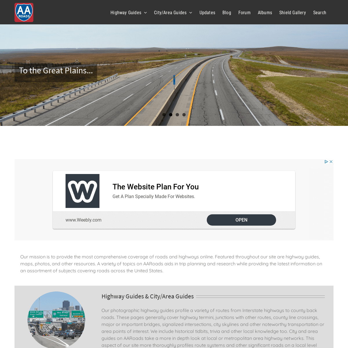
TO THE GREAT PLAINS...*
AND THE GULF COAST...*
... TO THE EAST
* 1
* 2
* 3
* 4
*
* �
AARoads – The Online Highway Guide!Alex 2019-09-10T16:39:38-04:00 Our mission is to provide the most comprehensive coverage of roads and highways online. Featured throughout our site are highway guides, maps, photos, and other resources. A variety of topics on AARoads aids in trip planning and research while providing the latest information on an assortment of subjects covering roads across the United States. HIGHWAY GUIDES & CITY/AREA GUIDES Our photographic highway guides profile a variety of routes from Interstate highways to county back roads. These pages generally cover highway termini, junctions with other routes, county line crossings, major or important bridges, signalized intersections, city skylines and other noteworthy transportation or area points of interest. We include historical tidbits, trivia and other local knowledge too. City and area guides on AARoads take a more in depth look at local or metropolitan area highway networks. This aspect of our site more thoroughly profiles route systems and other significant roads on a local level with both a focus on historical alignments and map scans and also current expansion and future road projects. “ON THE ROAD” BLOG Our blog includes reports from recent travels that we take to update the web site or for trips to see new roads. Other posts cover road news on new Interstate corridors and construction projects from across the country, web site development, and topics covering toll roads among other content.AAROADS FORUM
Our online discussion forum offers a place for both road enthusiasts and general travelers to mingle and discuss a variety of subjects. Share photos, learn more about area construction projects from local members or find a road meet to attend near you. These topics and much more are covered on our 3,700 plusmember board.
AAROADS ALBUMS
AARoads’ Albums contains an array of photos taken during the early years of the web site and also an assortment from recent travels that are not incorporated into our more formal highway guides. Photos are cataloged by state, route type,county, city, etc.
SHIELD GALLERY
The AARoads Shield Gallery includes a collection of over 10,000 photos ranging from early era highway sign designs to modern trailblazers for touring routes and toll roads across the country. The bulk of this catalog consists of photos generously submitted from fellow road enthusiasts and long timecontributors.
INTERSTATE-GUIDE
AARoads’ Interstate-Guide delves even further covering current, past and future routes within the system. While the web site initially covered routes with a brief overview and a collection of end photos, development of pages over time enhances our coverage to include more extensive historical write-ups, an outline of recent modernization and widening projects, and expansion of the Interstate system with the growth of the I-11, I-49, I-69 and other corridors.__
HIGHWAY FONTS
Road signs across the U.S. use one of two fonts: FHWA Highway Gothic or Clearview. The latter became the exclusive type for states such as Michigan, Pennsylvania and Texas, while municipalities in other states switched their street signs to the newer type face. Interim approval for the font was previously rescinded by an FHWA mandate in February 2016, but reinstated in March 2018.Read More
__
COLORED ROUTE MARKERS Florida was one of several states to use colored route markers to aid in motorist navigation. Arizona, Mississippi, South Dakota and Washington also used a colored route format, but Florida’s system was the most extensive and longest lasting, remaining in place until1993.
Read More
Be sure also to follow us on social media for the latest in road news from across the country, photos and roadtrip reports from the field and major site updates.* About
* Contact
* FAQ
* Spotlights
* Testimonials
* Interstate-Guide
CONNECT WITH AAROADSSEARCH
Search for:
� 2000-2020 AARoads.com | All Rights Reserved | Privacy Policy /Terms of Use
Go to Top
Details
4